okopanja
-
Posts
2069 -
Joined
-
Last visited
Content Type
Profiles
Forums
Events
Everything posted by okopanja
-
Would a raspberry pi 5 run a DCS server?
okopanja replied to Dirt__'s topic in Multiplayer Server Administration
Nuc can do it, but intel did decide do discontinue. -
Why would that not be possible with an upgrade?
-
You seam to dislike Deka and J-8PP? In DCS or IRL?
-
reported internally R-3R is not giving launch warnings to its target
okopanja replied to Sarowa's topic in Weapon Bugs
Yes there is, it has so much less power and range, that probably EWRs which transmit in hundred of kW and MW are received by RWRs as way stronger source of signal. -
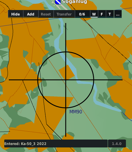
KA-50 ABRIS - map not scaling with symbology
okopanja replied to MortalMando's topic in Bugs and Problems
ABRIS updates are supposed to be with no delays when zooming in/out. My suspicion is that this started happening with one of the last 2.7 releases or early 2.8 release in October, when BS2 was reworked (it got greenish screen, became more sluggish when handling). The next major change occurred on BS3 release on Christmas. From that time we actually have 3 black sharks (at least us who bought it before): BS2, BS3 v2008 and BS3v2022. I will check if I have enough disk space to revert to one of prior versions. Changelogs: https://www.digitalcombatsimulator.com/en/news/changelog/ -
KA-50 ABRIS - map not scaling with symbology
okopanja replied to MortalMando's topic in Bugs and Problems
@MortalMando see my last comment and pleas try to zoom in ABRIS so you do not see outside of cockpit. What is your FPS, resolutin and machine? On my side 3440x1440 + i7 10750H + RTX 2070 Super + 64GB RAM (Dell G7 7700)? -
Exactly both positive and negative votes are meaningless. ED will do what they think it's the best.
-
Will miss you, especially the video with banner message being towed...
-
KA-50 ABRIS - map not scaling with symbology
okopanja replied to MortalMando's topic in Bugs and Problems
Hi All, I have padlock on (did not even know what it is) and I observed following: - got rid of all mods, including my own and FC3 clickable cockpit. - loaded simple mission I used before - spawned into running hot Ka-50 on ground I observed 2 use cases: Use case 1: I zoom in view onto ABRIS. The zoom in, zoom out works with almost no noticeable delay. FPS is ~ 110-140 FPS Use case 2: I zoom out so not only cockpit, but outside is visible. Zoom in, zoom out suffers from noticeable delays before rendering map (updates delayed) and objects (updates fast). Observed FPS is ~ 90FPS. So clearly, it may be dependent on PC performance and how much it needs to work (wider scene requires rendering of not only ABRIS and cockpit but also terrain). -
Just a gentle reminder that Su-17/22 is not 4th generation fighter, and that this goes outside of the topic...
-
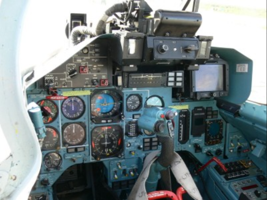
Shark Planner: waypoint entry into Ka-50 ABRIS and PVI-800 from F10
okopanja replied to okopanja's topic in DCS Modding
v1.4.0 After longer absence from DCS(6 weeks) I resumed work and are happy to announce a new release with some features that were missing from SharkPlanner. What's Changed Implemented experimental entry of target points into ABRIS Implemented configuration option panel SharkPlanner has now it's own configuration file located here: %USERPROFILE%\Saved Games\DCS.openbeta\Config\SharkPlanner.json (the file will be generated on first run) Improved Logging facilities. It is possible to change verbosity of SharkPlanner.log in runtime Bugfixes Fixed issue with ABRIS and Ka-50 BS2 by @okopanja in #69 Fixed issue where Logging would not filter out messages based on verbosity level Entry of targets points With 1.4.0 experimental entry of target points into ABRIS was added but is disabled by default. The target entry into ABRIS has following limitations Since it is not possible to distinguish the targets from existing map objects, entry will be skipped if existing map object is very close to target. You can address this by using ABRIS itself to remove existing object. The entry of targets is not 100% reliable. In some cases the entry will switch ABRIS into wrong sub modes. It is not clear why this occurs and weather it's possible achieve 100% reliable entry. If you notice odd behavior you may need to reload mission or reslot. Configuration panel allows you to disable this feature, but I kindly ask you to test and report problems. When reporting problems I kindly ask for following information: Short description of a problem If you are able please record a video and upload to e.g. youtube Attach configuration file: %USERPROFILE%\Saved Games\DCS.openbeta\Config\SharkPlanner.json Attach log file: %USERPROFILE%\Saved Games\DCS.openbeta\Logs\dcs.log Attach log file with DEBUG output enabled: %USERPROFILE%\Saved Games\DCS.openbeta\Logs\SharkPlanner.log Options dialog Options dialog can be access in following way: Activate SharkPlanner with CTR+SHIFT+SPACE Inside the control button area locate and click the following button Options will appear. Use the buttons to navigated to each section where you can modify options Each time you modify %USERPROFILE%\Saved Games\DCS.openbeta\SharkPlanner.json in Config folder will be saved Full Changelog: v1.3.0...v1.4.0
-
The number of votes is rather small, so you can not make the conclusions. In light of IRL events it seams plausable to add at least some of those modern weapons. By this I do not mean only a single side or country. Have in mind that at the end it is the mission designer(with some effort) who decides to include them or not.
-
If I have to guess Wag's world map would start by bridging the gaps between Caucasus, Syria and PG.
-
Actually extending Caucasus map east and down to the middle east would also make sense.
-
This is the first video in which I see real ABRIS working a bit later from 4:20
-
The stuff present in red FC3 would not be much different from what would FF equivalent be. Missing are things like radio, more detailed DL modeling including command interface for DL, detailed navigation system modeling, but from the VCS point of view it can not disclose more than what was disclosed so far. Somebody will say this is a matter of their national security, but... Su-27/Mig-29 in the 80s variants are already de-facto heavily compromised aircrafts due to: Manuals circulating online for Su-27SK Slides from UKR detailing some of the radar operation. These bastardized slides are far cry from actual documentation, but provide certain insight in basic operation. Fact that Belarus sold 2xSu-27 to USA in 1995 as well as Ukraine which also sold 2xSu-27s from it's inventory around 2009. We can safely assume that along airframes, weapons spare parts and maintenance documentation also got delivered So in practical sense FF 80s flanker would not jeopardize them more then they already are now. Now logic and politics does not always go the same way, so this remains a taboo theme, despite the beans were spilled long time ago. As for modern airframes, we can safely forget them. Even the existing ones are modeled with relatively large part of imagination in places where documentation is confidential. I am well aware that these air-frames were originally delivered with an empty space for RWR, but the image I located does not look recent, but you are free to correct me with more reliable source. I think it's safe to conclude that all mentioned airframes would sell very well, even if they were done in their early 80s states. I speculate that probability of having Mig-29A is rather high. One day ED will simply announce: surprise we got the new module for you.
-
null
-
Shkval Continues to make fps go ALOT lower both ST/MT.
okopanja replied to Ace5's topic in Bugs and Problems
I did not change my settings (or used mirrors), and also observed this multiple times. Most likely to reproduce is when flying blueflag, eg. 80s and trying to use the shkval near airports. The FPS which was quite high until this moment, turns into the slide show and it is very difficult to maneuver and fly (hover). -
@icemacanyou might want to take a look at A-4 mod for a reference. This mod is full fidelity.
-
Carry on "hladni" dude, judging on cockpit you wish to implement modernized Orao variant. I recall Vultur did not feature Mavericks B, what was used instead?
-
2023-09-15 08-50-25.mp4 Another interesting: - climbed - popped 2 chaff Missile goes stupid without achieving the notch conditions. Could this be ECM bug?
-
At this distance ECM does not play any effect on missile. In all cases missiles got notched. This occurs when the relative speed of closure is below the doppler filter speed, which causes it not to be able to distinguish the target from the background and chaff. Incidence of 90 degree toward the target. You can repeat the same results with R-77/SD-10 as well. Further tip: if you still believe this is wrong behavior make sure you provide the TRK/MIZ files which can be used by developers to replicate the issues.
-
IMHO: strongly no. PL-12 at present is even more unreliable than AMRAAM from one year ago. It exhibits strange behaviors and switching SD-10 to this API would not be good for Jeff. Someone earlier posted that PL-12 has kill ration better than SD-10 on one of the servers. It would be interesting to examine situations. Pictures were posted with J-11A carrying PL-12, so likely not so unrealistic.