okopanja
-
Posts
2068 -
Joined
-
Last visited
Content Type
Profiles
Forums
Events
Everything posted by okopanja
-
Sorry but how did you conclude this is R-27ER?
-
Nope, I did not say that. In case of some FC3 airplanes, everything you listed (e.g. navigation, INS, ...) is indeed missing. I hope with time we will actually get a simulation in the areas I mentioned, as well as transition of FC3 to FF. And yes this also include "banned" modules such as Fulcrum/Flanker/Eegle. Giving them FF makeover would not disclose more information than it is currently, since in eitherway these aircraft (talking about early 80s, not subsequent upgrades and derivations) are much simpler compared to e.g. modern multirole fighters.
-
Not entirely true. I think you are giving too much credit to FF. The major difference is availability of distinct devices and their relations. However this is often not modeled consistantly or even introduces non-existing devices that do not exist on real aircraft. Furthermore sensor devices appear to be often modeled outside of operating principles of real devices, perhaps the best example are radars, which are essentially checking the line of sight between objects and are calculating radar equation. In other words radar is emulated. Simulation of radar would include implementing each radar component along its inputs, operation and output. E.g. this would allow for realistic implementation of ECM effects. FLIR/night vision are if I am correct in most cases renders of camera views to which the varioty of filters are applied.
-
KA-50 ABRIS - map not scaling with symbology
okopanja replied to MortalMando's topic in Bugs and Problems
I have observed the same. There is actually a delay until map gets rendered in proper scale. -
LoGetTWSInfo returns nill while Sensor export is true
okopanja replied to dutchie_031's topic in How To Mod for DCS World
These functions were meant for FC3, FF provided devices. The trouble is: devices often do not provide the needed information. -
investigating R-27ER Goes Active After Dropped Lock
okopanja replied to sleestak's topic in Weapon Bugs
Actually, F-15E did notch your aircraft radar, hence the lock got dropped. In HOJ ER will use proportional navigation. In your case I believe it was never in HOJ mode. In fact, I believe that your R-27ER started guiding from the moment R-77 became active at ~ 22km or 12nm, which is exact distance where R-77 goes active. The interesting thing is that R-77 was actually dumb all the time. -
Server admin can edit mission loadout, afterwards clean unmodified client can use it.
-
Running dedicated server on Linux using wine
okopanja replied to xfirf's topic in Multiplayer Server Administration
DCS server itself is free. E.g. I have separate acount for server, no purchases and access to all maps. The license in question is about windows 10/11. Linux option would eliminate that dependency. I tried running via wine, but had issues with server needing UI. Since then at the end I acquired a legal windows license. -
Question between Black Shark 2 and newer Black Shark 3?
okopanja replied to JOKERACTS's topic in DCS: Ka-50 Black Shark 3
ODS switch is visible on one of the IRL cockpits. You can find both the switch and domes of laser protection system. https://www.net-maquettes.com/pictures/kamov-ka-50-hokum-walkaround/ You will notice that some pictures have been censored, but on some they missed to do that. It is only debatable if it had Pastel RWR and chaff dispensers. -
The ECM is highly effective in BVR when properly used. When inproperly used it can actually increase the probability of getting killed. As Wags would say in his famous viper video when jammer pod got introduced: "pros and cons, pros and cons". First of all there are 2 kinds of jamming in DCS: continuous, which denies range information lock breaking which occurs only when your aircraft is locked. The pod detected when the STT lock occurs Both of these affect radars and missiles in DCS. Continuous has following benefits: reduced SA of your opponent in most cases. missiles lofting can not be calculated based on range, since it is obviously missing. Therefore the chosen guidance law is to follow the angular information only, which results in no loft, thus reduced range The disadvantages are: you alert opponent about your presence sooner He can launch a missile in home-on-jam mode, which will allow him to quietly disengage while the missile still guides silently to the source of jamming signal: you . Friendlies might be blinded by your jamming and launch missile in home-on-jam mode as well. Lock breaking benefits: you prevent guy from shooting you at longer range he can not use home-on-jam, since the moment it is interrupted there s no signal anymore to guide on you jam only on demand, thus not alerting too much about your presence Lock breaking disadvantages: SA of your opponent is not spoiled, he knows your range from scans. Others are welcome to add more if I missed something.
-
@uboatspresent Pl-12 exhibits some behaviors specific to one prior version of AMRAAM API, would it be possible to apply the latest API version to PL-12? 2023-07-23 08-38-01.mp4
-
Shark Planner: waypoint entry into Ka-50 ABRIS and PVI-800 from F10
okopanja replied to okopanja's topic in DCS Modding
v1.3.0 Black shark is not alone in SharkPlanner anymore: support for SA-342 Gazelle was implemented. NADIR Navigation System allows entry of up to 9 waypoints. As reminder NADIR does not direct autopilot, so selection of entered waypoints and steering has to be done manually. All 3 variants are supported. What's Changed New features Added support for NADIR in SA-342 Gazelle Added ControlWindow reference to experimental callback call Bugfixes Fixed issue with ABRIS and Ka-50 BS2 Fixed removal of targetpoints in target list Fixed control button being disabled when switching slot Corrected entry of 10th target into PVI-800 Corrected number of fixpoints (4) for Black Shark Progressbar is now above elevation chart (will be moved in future) Replaced the literal strings with constants Full Changelog: v1.2.0...v1.3.0
-
I am having exactly the same issue you had before. Did you manage to resolve the problem and how?
-
Shark Planner: waypoint entry into Ka-50 ABRIS and PVI-800 from F10
okopanja replied to okopanja's topic in DCS Modding
v1.2.1 Minor release, if you do not fly BS2 you do not need to update from v1.2.0 What's Changed BS2 entry works again. -
Advanced Radar cross section/IR exhaust modelling
okopanja replied to Default774's topic in DCS Core Wish List
Nothing changed, but at some point developers promised to take a look a the skin heating effect. -
Congrats dudes, you survived for 1.5 year I was dwelling on buying throttle and playing with nintendo pro controller instead. Some timeline would be appreciated.
-
I guess you got link? From what I have seen the HDD has very very intensive output, much stronger than TV screen like SHKVAL. Monochrome monitors should actually have a great sharp contrast. The sharpness deteriorate with time, so after several years they may look just like SHKVAL. The beam width can get worse over time, and also tubes need more time to heat up and produce less bright image, resulting less contrast as well. I remember my grandma having 2 B&W TVs and sharply remember when one replace the other (she did not want color screen!). At that time I carried my C-64 at holidays and was astonished to find out that our color TV was actually much worse option for displaying of text. In case of shkval, I can not be sure, since there are multiple versions with different geometry of screens as well as used phosphorus. The one @MAXsennaposted looks newer than one of the DCS. Also note that cockpit shadows ON actually degraded the contrast in BS2/BS3 due to that damn green filter they added. Somewhere in Sept/Oct of 2022 for BS2 if I remember. Back than I was told to turn off shadows.
-
Such sun shield was used on Fulcrums, Flankers as well ka-50 IRL. In DCS flanker/fulcrum this shield does not seam to have any effect (perhaps I should check my settings move head up). The worst situation is with Su-33, where glare is absolutely not bearable. In case of ka-50 there were cockpit variations with different display, some of which did not have the shield. In addition to this Ka-50 had green curtains on side and an extra curtain in upper window. None of this can be actually used.
-
correct, the need for helicopters will remain in transport role and expand. Helicopter gunships will have to seek the secondary/reserve role with mandatory ability to hit targets out of line-of-sight, hidden behind obstacles. This will lead to at least 2 things which we already see presently in modern day with some helicopters. - fire and forget, based on information obtained directly or by 3rd party - man-in-the-loop systems, e.g. fiber optic transported feedback. Jamming is already a reality. In present conflict the effect are already visible. However the jamming at the moment is not in such condition to be deployed on tactical level. The devices are still comparatively large and expensive. On the other side drones have approached the level where each squad has them today. Tomorrow each soldier will have at least one.
-
do not forget small sized vehicles... . In video you can see AR-55 (Fiat Campagnola)
-
[SAMs] P-14 "Tall King" as search radar for SA-5 "Gammon"
okopanja replied to Wild_Weasel_31's topic in DCS Core Wish List
The S-200 could also have own EWR radar in case of ASURK being disconnected. A single ASURK-1M could command with up to 8 batteries, where up to 5 could be S-200. Typcally this was a mix of S-75, S-125, and S-200 systems. The usage of independent SAMS (S-75) in Vietnam war with coverage of 4-7 uncoordinated overlapping batteries, did lead to events where a single target is engaged by multiple batteries, resulting in rather comical situations where target got hit multiple times, or even parts of falling busters of previously fired rockets getting targeting as well. Clearly ED's SAMs, even the most modern ones, do not have this kind of de-conflicting and prioritization. Essentially it is on the level of early 60s. -
[SAMs] P-14 "Tall King" as search radar for SA-5 "Gammon"
okopanja replied to Wild_Weasel_31's topic in DCS Core Wish List
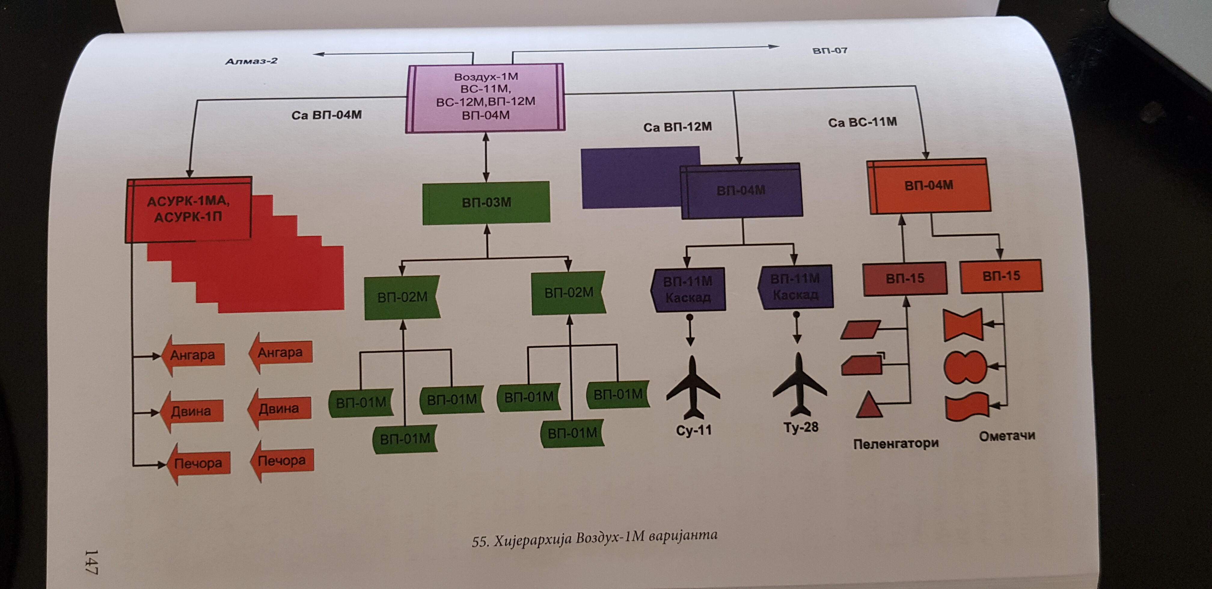
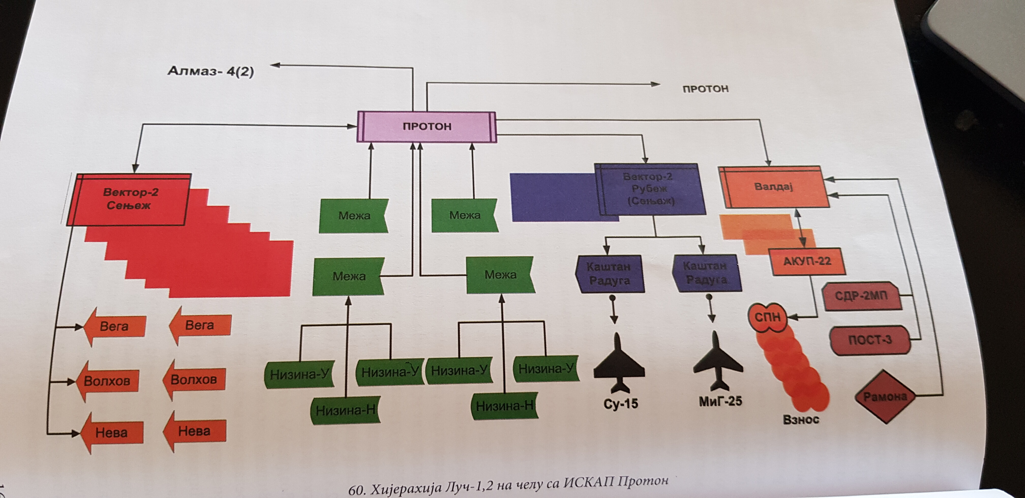
Situation is a bit more complex. What you do not realize from that manual is that the SAM site could be controlled/supplied with targets from command posts integrating multiple different sensors. It does not have to be a single radar, in fact the system did secure in this way resistance to the jamming... In most cases the deployed variants outside of Soviet union were of simple topological. In contrast Soviet layout was much more complex and resistant to e.g. Jamming. I will attach 2 diagrams that are not directly from Soviet sources, but rather book published last year. https://tangosix.rs/2022/19/07/nova-knjiga-esalon-sve-o-sovjetskim-i-ruskim-radarskim-sredstvima-komandno-informacionim-sistemima-i-sistemima-automatizacije/
-
This message will occur also when vkb is restarted. E.g. when you load a different config. Your issue might be insufficient power on USB and/or faulty usb cable. Are your USB hubs powered by external power supply? I had constant disconnects until I got powered hub.
-
What about naval helicopters?
-
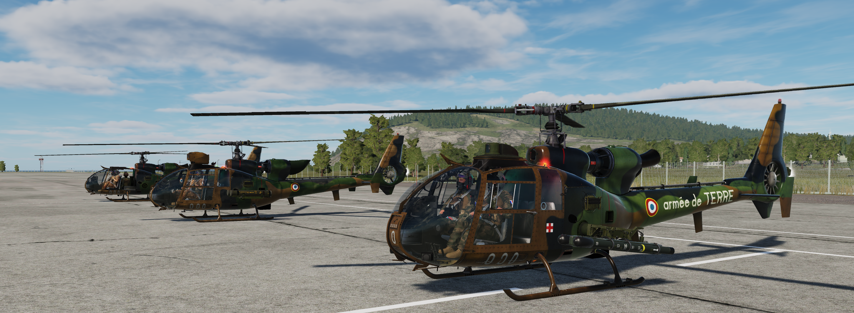
Not soviet, but rather a mix of blue and red. Gazelle was actually produced in Yugoslavia and incorporated modified soviet weapons. Here is demonstration of Gazelle with Strela-2m missile (in addition to 4xATGMs)