Backy 51
-
Posts
1536 -
Joined
-
Last visited
Content Type
Profiles
Forums
Events
Everything posted by Backy 51
-
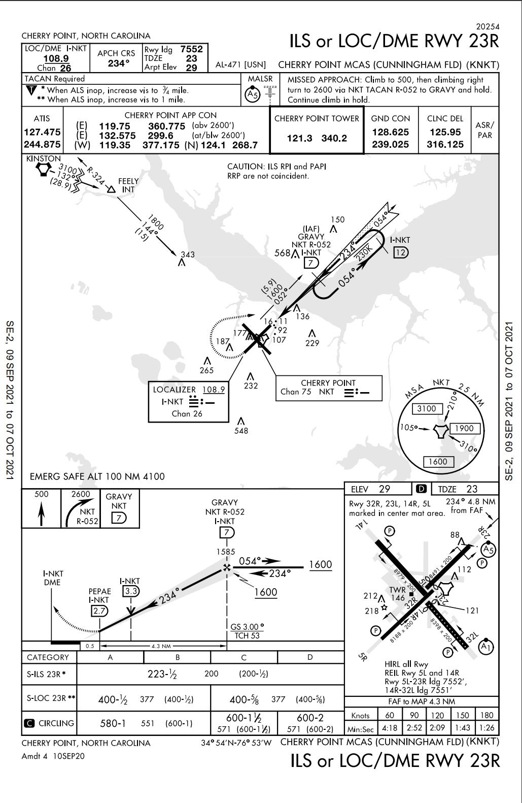
Missed it! Format change I guess ... flew into NKT many times in the Herc.
-
Been a while since I've had to take an Instrument Refresher Course, but I'm pretty sure that the above 2017/2020 Cherry Point instrument approach plates shown above do not reference ICLS or that ICLS equipment is installed at Cherry Point. Perhaps one of our current active-duty USMC military pilots could further explain why the TACAN REQUIRED was dropped from the 2017 approach plate to the 2020 approach plate? I believe ICLS is only a ship-borne guidance system with unique certification requirements.

-
Convert your marked up imagery to GeoTIFF and it should work fine.
-
CH47 Chinook, flyable, clickable, EFM
Backy 51 replied to Dweeeeb's topic in Flyable/Drivable Mods for DCS World
For those wanting UV Maps ... I offer you two. One black, one white. Enjoy and let's see some great skins! CH47MAIN_UV_MAPS.7z -
Walk it back from the DCS World OpenBeta root install or DCS World OpenBeta Saved Games folder to mimic the directory structure that your "mod" modifies. Examples: Root install location: E:\DCS World OpenBeta\CoreMods\aircraft\AV8BNA\Liveries\AV8BNA (Location in the "DCS root install" folder location for adding a Harrier skin. Before all you "experts" jump me, this is just being used as a simple example. I fully know the Saved Games\Liveries structure is the ideal place for custom liveries! ) In OvGME you would browse to the E:\DCS World OpenBeta folder and create that as the storage location and then package your mod in the folder structure of CoreMods\aircraft\AV8BNA\Liveries\AV8BNA\VMA-123 ( VMA-123 would be your hypothetical new Harrier skin). ------------------------------------------------------------------------------------------------------------------------------------------------------------------------ Saved Games install location: C:\Your Computer Name\Your User Name\Saved Games\DCS.openbeta\Mods\tech (Location where you would drop a ship mod, for example) In OvGME you would browse to the C:\Your Computer Name\Your User Name\Saved Games\DCS.openbeta folder and create that as the storage location and then package your mod in the folder structure of Mods\tech\CVN-123 ( CVN-123 would be your hypothetical new carrier mod). Attached is a powerpoint presentation and all the needed files to complete a "DCS World OpenBeta root install" mod using OvGME. I hope you find this useful. Cheers, Scifer_Syria_Beacon_Mod_and_OvGME.zip
-
Enhanced Position Location Reporting System (EPLRS) If a DCS World aircraft or vehicle is EPLRS-capable, (this is coded in the LUA for each US aircraft/vehicle), DCS World aircraft that have either SADL (A-10) or LINK-16 (F-16/18) will have a friendly symbol displayed on their appropriate MFD situational awareness page. Read the Link-16 section in the Hornet manual for details.
- 2 replies
-
- 2
-

-
- mission editor
- eplrs
- (and 1 more)
-
Nice light poles Ghostrida9! Could you share those please?
-
Version 1.0 released for DCS World Version 2.7.5.X. The Combat Caravans are COIN/ISR aircraft used by Air Forces around the globe. They are ideal for the Syria and Persian Gulf map where they are presently in operation by several nations. Armed with AGM-114K, 2.75" FFAR HE, WP and APKWS; they are very capable and can also be used in the AFAC role. Enjoy the Mod! LINK: https://www.digitalcombatsimulator.com/en/files/3318245/
-
-
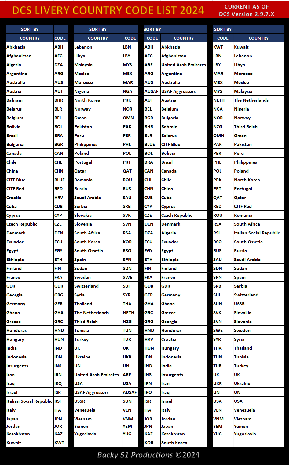
Here's something I put together today to assist Livery Makers with their Description.lua file country code information. It is a list of all the current Country Codes as of 24AUG24. I made it from data within the latest 2.9.7.X DCS Open Beta build. Hope you find it helpful! null CC LIST 2024 UPDATE.zip
- 3 replies
-
- 11
-
-

-
Custom beacons.lua ILS not working
Backy 51 replied to Scifer's topic in Utility/Program Mods for DCS World
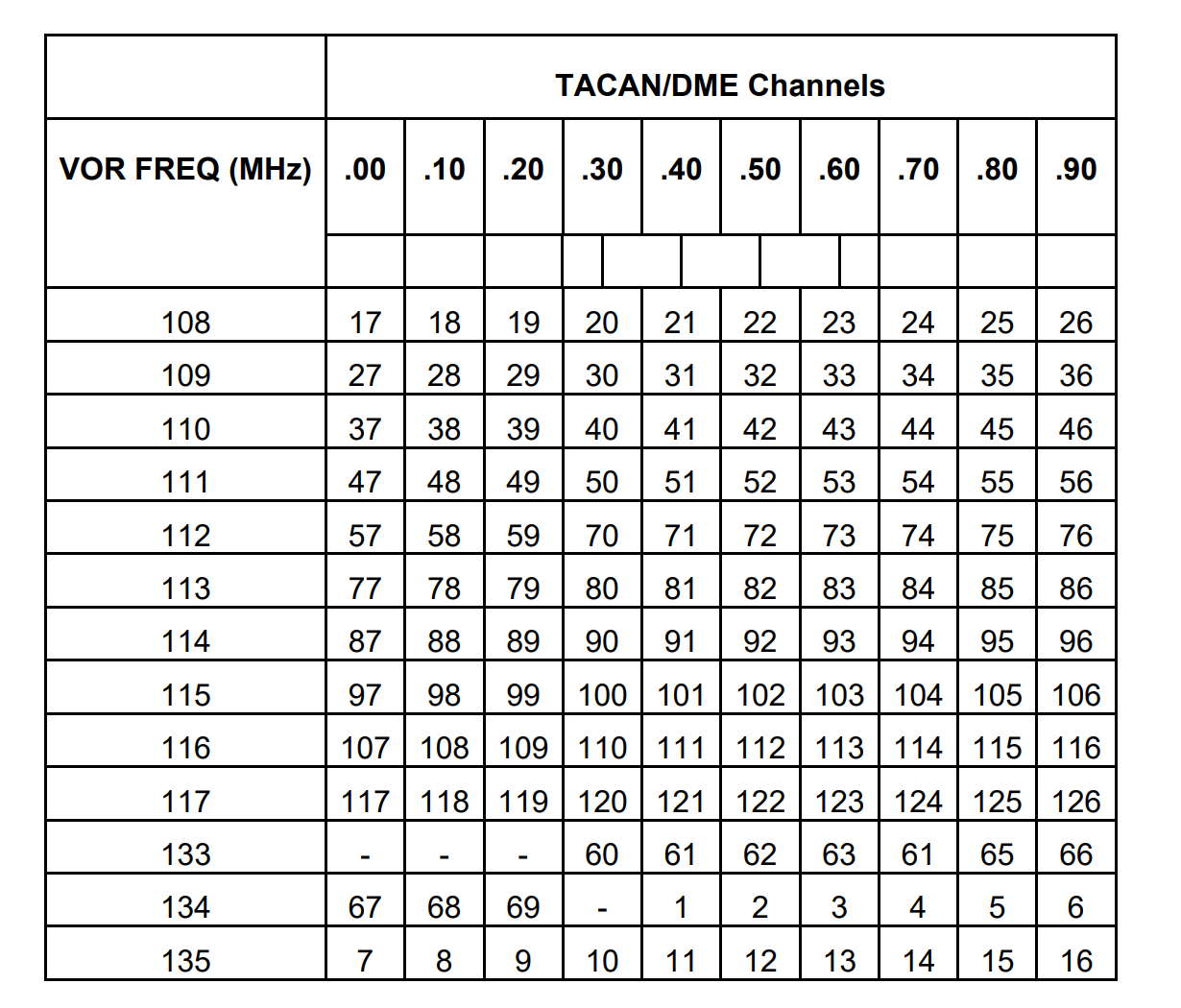
VOR/DME pairing chart ...
-
Custom beacons.lua ILS not working
Backy 51 replied to Scifer's topic in Utility/Program Mods for DCS World
Your ILS localizer/glideslope frequency pairing is out of range ... -
Enjoy the teaser ... WIP coming soon.
-
Civilian Objects And Vehicles
Backy 51 replied to Eight Ball's topic in Static/AI Mods for DCS World
I'll look into it ... got two projects underway ... so may be a while. -
Civilian Objects And Vehicles
Backy 51 replied to Eight Ball's topic in Static/AI Mods for DCS World
Follow Eightball's install instruction and read my readme file. Essentially, Your Saved Games/Mods/Tech folder ... -
Civilian Objects And Vehicles
Backy 51 replied to Eight Ball's topic in Static/AI Mods for DCS World
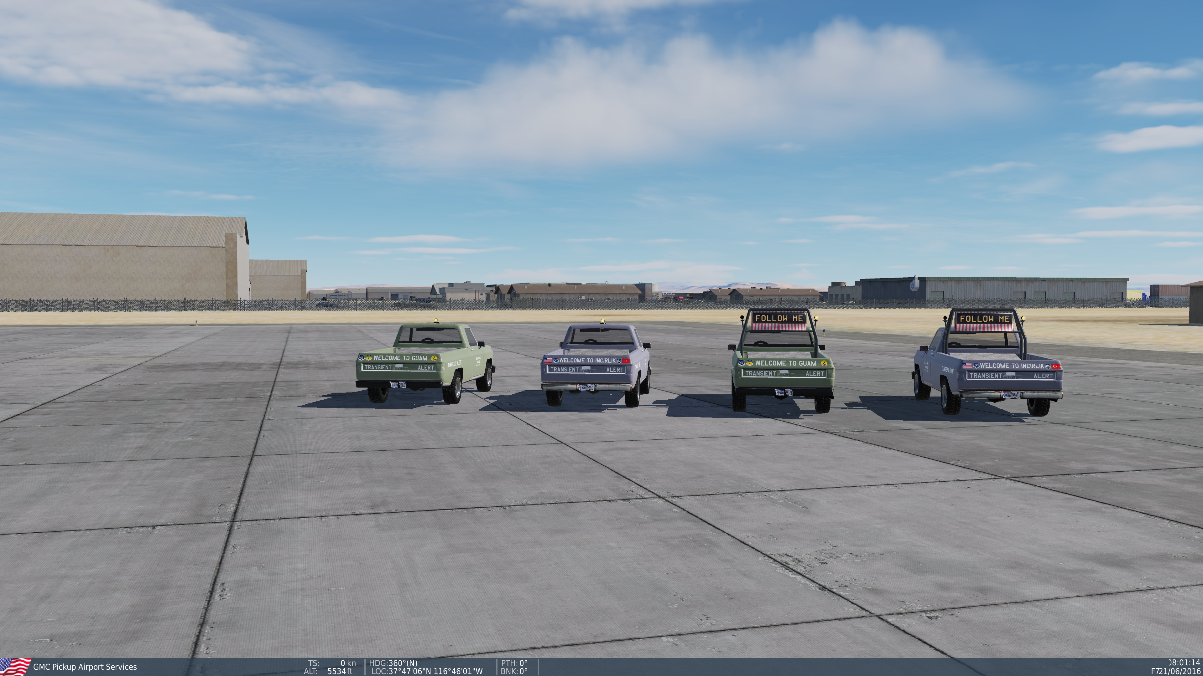
Two more "skins" for Eightball's excellent Airport Services Vehicle Mod. Follow Me and TA trucks for Andersen and Incirlik Air Bases. Link ibelow. Enjoy! See attachment for skins mentioned above at: https://www.digitalcombatsimulator.com/en/files/3317707/ Requires 7-zip to extract. Enjoy! Version 1.1 updated to fix burned out headlight ... ( thanks Warlord)
-
F11 Free Camera. Added control with classic WASD keys.
Backy 51 replied to fagulha's topic in How To Mod for DCS World
CTRL+WASD or SHFT+WASD I believe provides a little of what you want. -
Coming Soon - Enjoy the show!
- 1 reply
-
- 3
-
-
-
Phonetic Alphabet and Blank Airdrome cards.
Backy 51 replied to ZQuickSilverZ's topic in DCS Modding
Love that "old school" vibe ... -
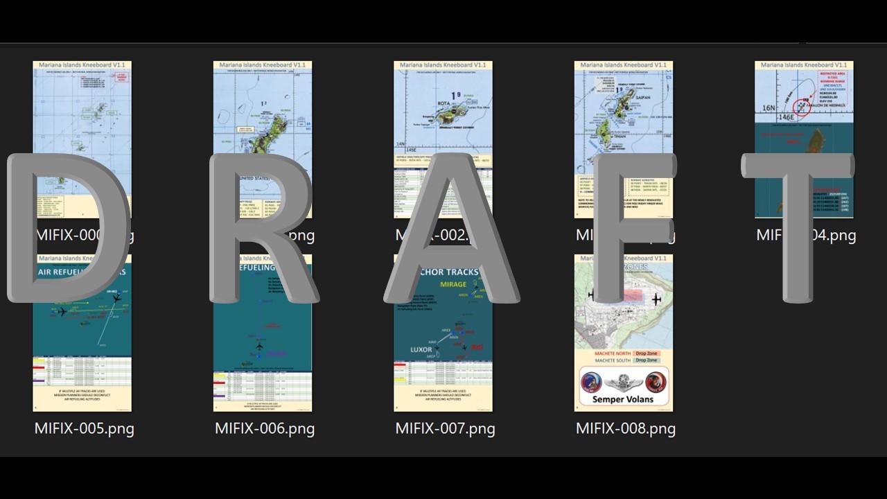
SUPERCEDED BY Greetings DCS Aviators! I hope everyone is enjoying the DCS Mariana(s) Islands Map. I've created some Kneeboard products you may find useful to enhance your Mariana Island Map flying experience. All information within is public sources from the Univ of Texas Library and Andersen AFB publicly released data that fits the historical timeline of the DCS World simulator. - 1:500,000 Scale Tactical Pilotage Chart (TPC) coverage of all Mariana Islands - Machete North and South Drop Zone depiction - Andersen AFB Communications Card Data - Air Refueling and Anchor Tracks Route Data (Map and Spreadsheet) - Air Refueling and Anchor Tracks Route Static Template (STM) files for use in the mission editor - R-7201 Restricted Area Range DPMI Weaponeering Data (Notional) - DCS Mariana Island Map Navaid and Airfield Communications Data Place the included STM files in the following location: C:\Users\Your User Name\Saved Games\DCS.openbeta\StaticTemplate Place the included Kneeboard PNG files in the following location: C:\Users\Your User Name\Saved Games\DCS.openbeta\Kneeboard\Your Aircraft Of Choice The DCS_MARIANAS_KNEEBOARD_V1.1 PDF is formated to work on your iPad and most popular tablets. DOWNLOAD LINK: https://www.digitalcombatsimulator.com/en/files/3317445/ SAMPLES BELOW
-
In the User's Manual ... p. 96 ...
-
stageDemon - a simple interactive in-mission testing and debugging tool
Backy 51 replied to cfrag's topic in Mission Editor
Bravo Eduardo! Nail meet Hammer. But I truly understand cfrag's belief that the community contains many toxic personalities ... ban them as you do and move on. It's sadly just a part of dealing with the public at large. -
stageDemon - a simple interactive in-mission testing and debugging tool
Backy 51 replied to cfrag's topic in Mission Editor
cfrag, Ignore the downvote nonsense ... keep improving your app and press on! -
Confirmed still a problem. You often get an error message about flat ground trying to place a helo on these helopads. Many near the Turkish/Syrian border have trees encroaching on or growing up through the helipad platform.
-
Great job Comrade Doge! I tried "The Way" on the Nevada Map and the ingest of the Longitude is in Easting instead of Westing. Any chance of tweaking the app for Western Hemisphere coordinates? I just went in and overwrote the coordinates manually with W vs. E and the marker pulled point was as expected and then showed up on SEQI. I've not tested in the Eastern Hemisphere maps of Syria, PG, etc, but I expect everything works as advertised on those maps. Thanks for a nifty and simple targeting/waypoint implementation for the Viper and Hornet.