Ramsay
-
Posts
3749 -
Joined
-
Last visited
Content Type
Profiles
Forums
Events
Everything posted by Ramsay
-
fixed Incorrect ground speed being shown by NS430
Ramsay replied to jonsky7's topic in Bugs and Problems
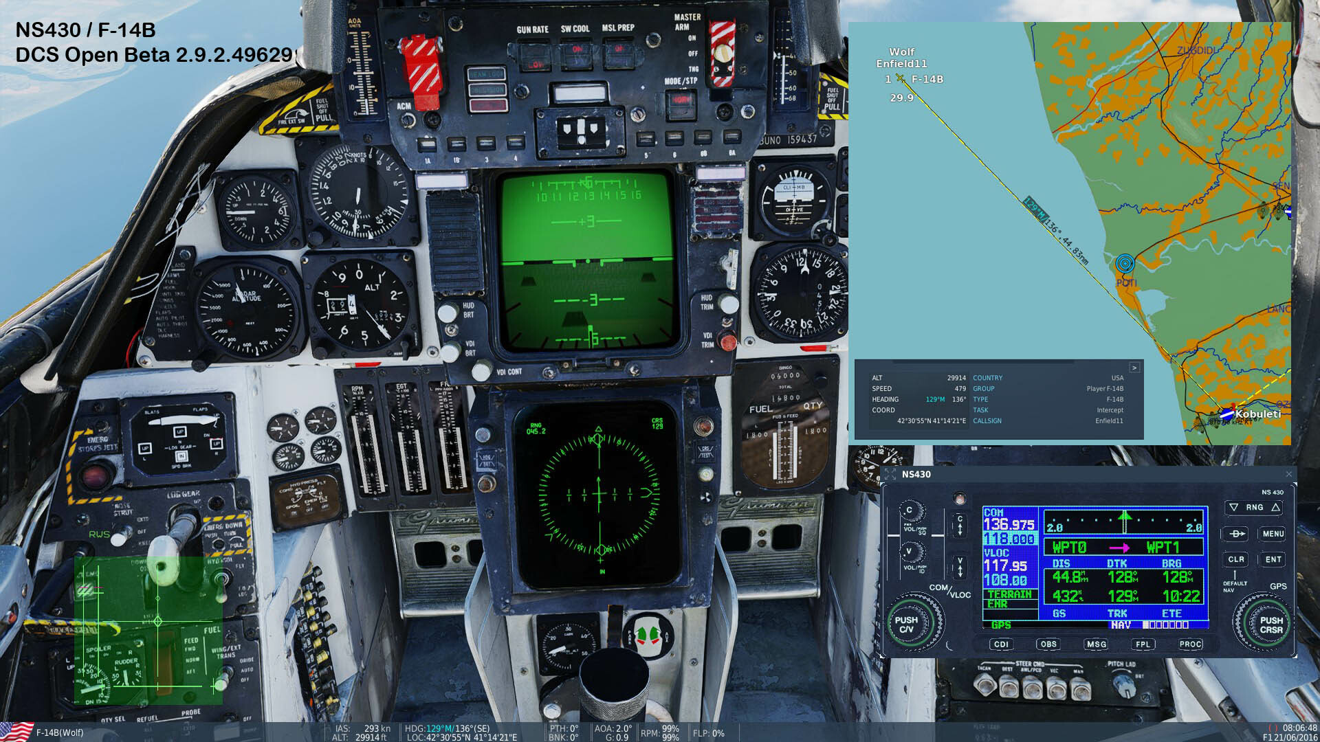
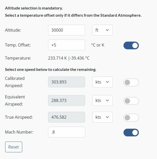
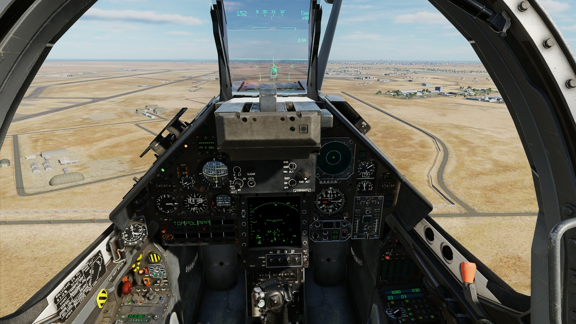
No, the NS430 GS value can be close to IAS when low/slow, but high and fast it follows the higher GS, under reporting by ~10% For a F-14B at 0.8 IMN @ 30,000 ft, • NS430 gave GS = 432 Kt • Cockpit IAS = ~310 KIAS • Cockpit Info Bar (LCtrl+Y) IAS = 293 KIAS • F10 Map GS = 479 For info. 0.8 IMN Airspeed converter https://aerotoolbox.com/airspeed-conversions/
-
fixed Incorrect ground speed being shown by NS430
Ramsay replied to jonsky7's topic in Bugs and Problems
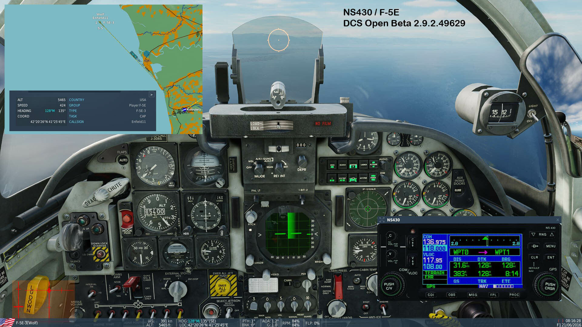
Open Beta looks excellent with most (if not all) of the NS430 Magnetic and True bearings reading correctly. I'm not sure about the Ground Speed (perhaps still WIP) as it seems to report a speed higher than IAS but ~5-10% less than the GS reported by other methods i.e. F10 map, INS, etc. this seems confirmed by ETE overestimating the time taken to fly a route leg. Either way, GS is much better than it was, please pass on my thanks to which ever team is responsible. Detail: ✔ Distance 31.6 NM ? Ground Speed 383 KTS (correct value ~424 KTS) ✔ Ground Track 128°M (IMHO within limits) ETE 8:14 (incorrect should be approx. 4:28) ✔ Desired Track 128°M ✔ Bearing to waypoint 128°M (IMHO within limits) null Tested in DCS Open Beta Multi-thread 2.9.2.49629 using F-5E, F-14B, SA-342L and MB-339A, Caucasus Map
-
Testing with the latest Open Beta 2.9.2.49629 - this doesn't seem fixed i.e. behaviour with RNAV and TACAN CDI, etc. remains the same when tested from Nellis.
-
The DCS AV-8B N/A is regularly included in Steam Sales i.e. 50% discount in Sept., 30% discount in the Summer Sale, etc. https://steamdb.info/app/759130/
-
In the case of the F-15E's Auto Acquisition Switch, the "standard terminology" used by SME's, Razbam, etc. is Forward, Aft and Down. I assumed the OP was familiar with the AACQ switch as well as giving the relevant page(s) in the DCS manual. In long hand the RL F-15E workbook says to "Push down on the auto acquisition switch to return to search", so you'll need to take your complaint to the USAF/Boeing.
-
AACQ is an abbreviation for the Auto Acquisition Switch found on the the F-15E pilot stick - it's a spring centred, two position plus depress switch used to change A2G HRM Map size, TPOD FoV, etc. I'm sure you know it but are getting confused by similar abbreviations used in differing airframes. See page 318 of DCS_F-15E_Flight_Manual_EN.pdf, 2023-12-12
-
TL;DR: AACQ DOWN returns (from TWS) to SEARCH (RWS) Detail: For more detail see page 326 of DCS_F-15E_Flight_Manual_EN.pdf, 2023-12-12
-
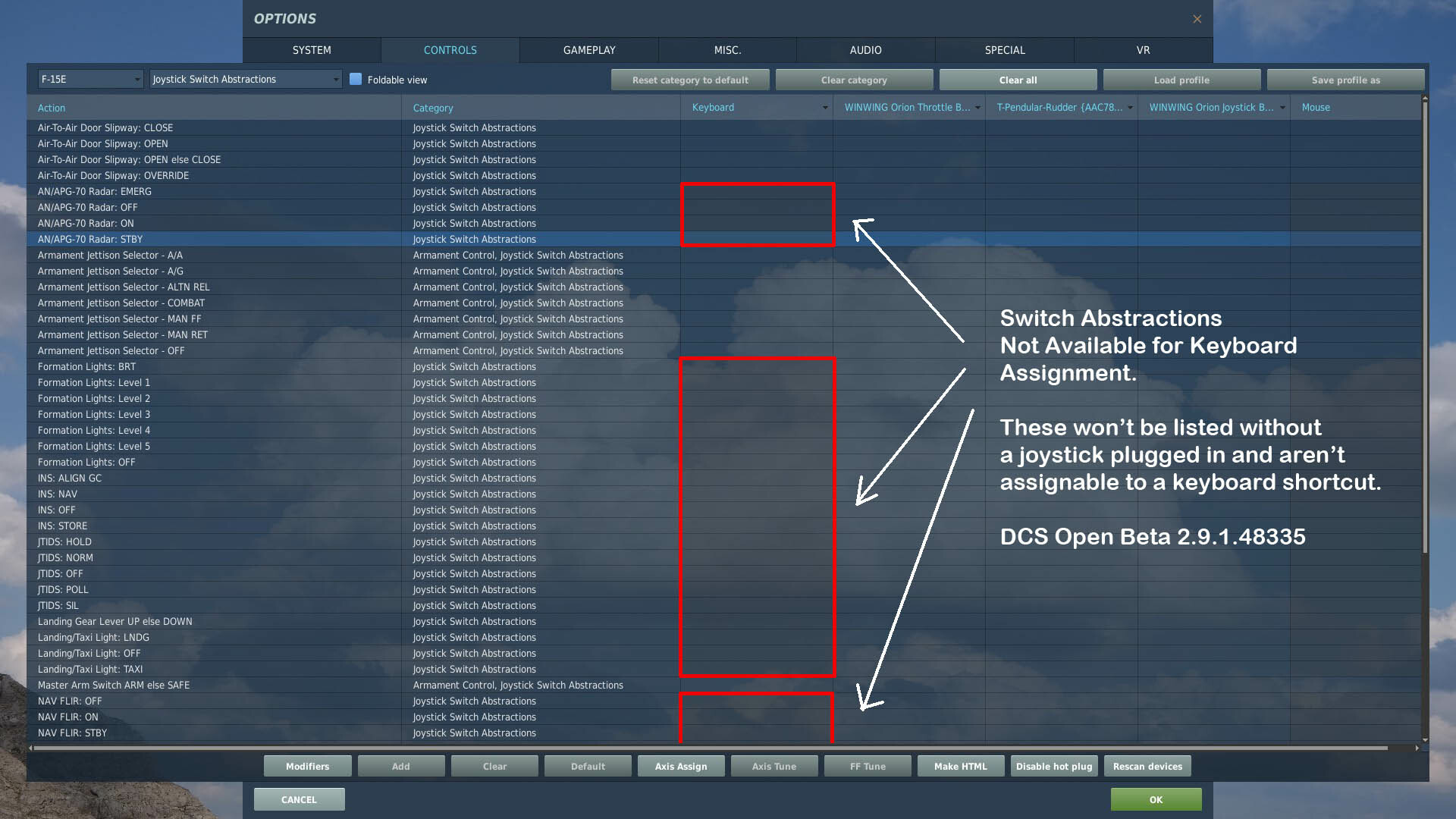
The binds are "Joystick Abstractions" and only appear when a joystick is plugged in. They can't be bound to the keyboard by default. Hence why @FierceLV is asking for the keyboard assignments to be fixed to work as intended. You would need to modify the default keyboard file to add them i.e. copy the relevant "AN/APG-70 Radar" section(s) from • DCS World\Mods\aircraft\F-15E\Input\F-15E\joystick\default.lua to • DCS World\Mods\aircraft\F-15E\Input\F-15E\keyboard\default.lua Your install looks correct. Tested in DCS World Open Beta 2.9.1.48335
-
Not AFAIK. Correct. No the limitation is barometric, AFAIK the low air pressure makes cooling the laser/electronics difficult. Above 25,000 ft ISA? the laser Safes to protect the pod from damage.
-
TL;DR: Al Dhafra's ILS is bugged and has been for a long time - the issue effects all modules. https://forum.dcs.world/topic/334755-al-dhafra-air-base-ils-issues/?do=findComment&comment=4411274 Detail: To land at Al Dhafra (zero wind) using the Mirage's ILS / synthetic runway :- 1. Ignore ATC's instructions to land on 13L and plan to line up for 31R 2. Tune ILS to 109.10MHz 3. Prep Waypoint CP/PD = 308°T / 03.0° (if using a landing waypoint - it will have the wrong direction). 4. Line up on final for 31R (306°M) i.e. using TCN 96X 5. Follow normal landing procedures using APP mode, Autopilot, etc. as desired. 6. Once Localiser and Glide Slope are captured - the synthetic runway will appear in the HUD. Tested using A-10C II and Mirage 2000C, DCS Open Beta Multi-thread 2.9.148335
-
Correct
-
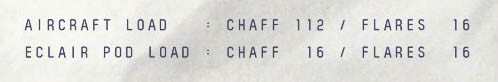
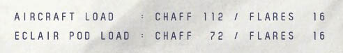
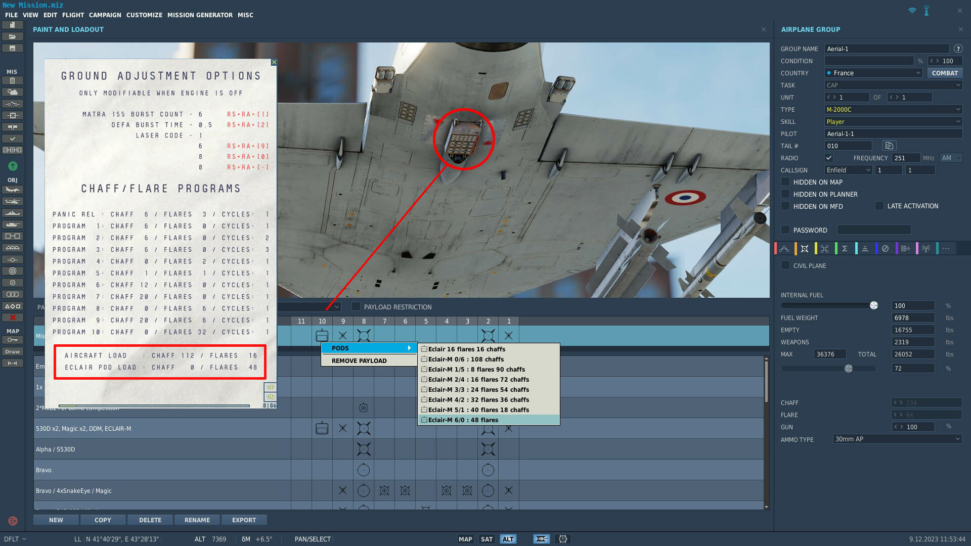
Sounds like you may be using a very old mission as the Mirage 2000C mission editor default should be 234 chaff / 64 flares i.e. the maximum allowable of each type, this is NOT the same as the amount carried/dispensable. This is explained in the DCS M-2000C Manual on page 375 The closest you can get to 30 flares is by equipping either :- • the older Eclair pod adds 16 flare and 16 chaff = total loadout of 32 flare / 128 chaff. or • the newer Eclair-M pod with a 2/4 loadout of 16 flare and 72 chaff = total loadout of 32 flare / 184 chaff You can't fit a partially filled decoy cartridge i.e. a 8 shot flare cartridge with only 6 flares.
-
TL;DR: You change the amount of chaff and flare carried by choosing different Eclair pod loadouts. Detail: You can not change the amount carried internally (112 chaff / 16 flares), however the Eclair/Eclair-M counter measure pods have different chaff/flare loadouts to choose from. The exact amount of chaff and flare carried can be confirmed via the kneeboard.
-
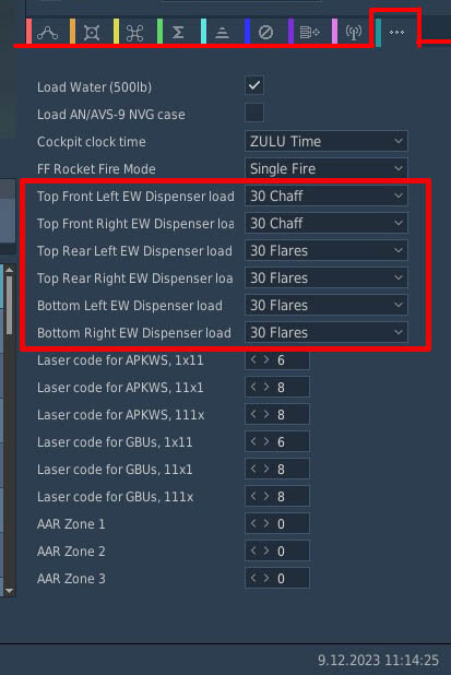
There are 6 dispenser cartridges and each one holds 30x chaff or 30x flares, so you can carry a max of 180 chaff or 180 flares or a combination of both. Cartridge selection is made using the aircraft's Special Options tab "•••" in the Mission Editor.
-
I usually cycle the Maverick Cage/Uncage button to get a 2nd/3rd Laser Maverick to detect the spot i.e. there seems to be a desync between the HUD/MFD symbology and the 2nd Mav's cage status. IIRC this is an already reported bug. https://forum.dcs.world/topic/316305-reported-tpod-situal-awareness-cue-moving-erratic/
-
The mission(s) need to be updated to use the current versions of the Gazelle's weapons. The mission(s) need resaving using the latest version of DCS - although set on a moon lit night, the moon and stars are now missing unless the mission is resaved i.e. using the Light Scattered Clouds preset, you'll get a few faint clouds and moon/stars that silhouette against the horizon. IIRC the mission (DCS 1.5.3 / 2016) was intended to be darker than shown in this youtube video from 4 years ago but NOT PITCH BLACK. Originally ground targets were marked by IR laser/marker from predator drones and visible using NVG [RShift+H]) - however I'm not sure if the old (2015) JTAC autolase script still works as intended (I reflew the mission several years ago and IIRC the IR markers were missing) YMMV. Tested using DCS Open Beta Multi-thread 2.9.1.48335 but not flown to completion.
-
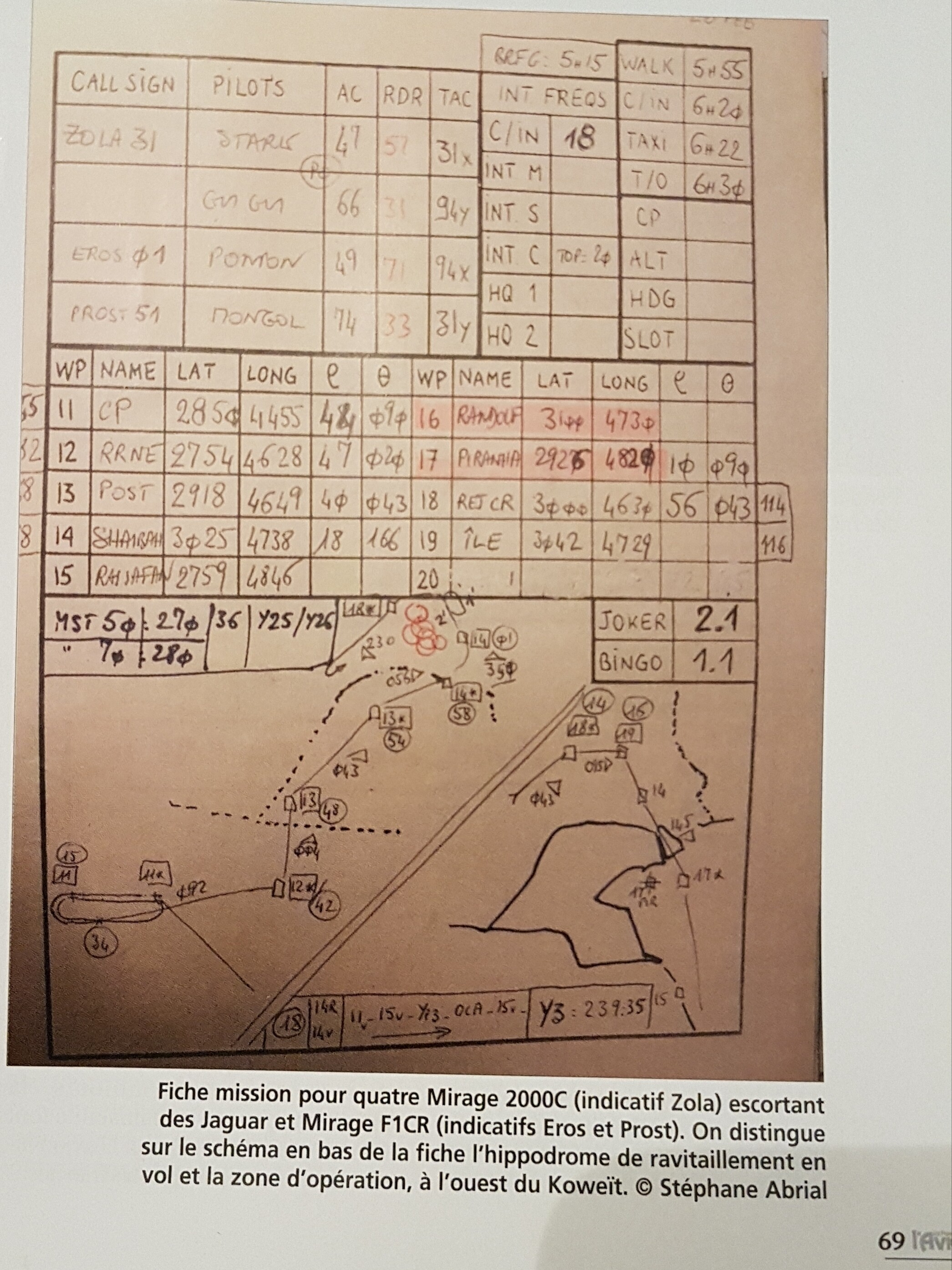
That is intended i.e. waypoints 11 - 19 from the data cartridge might define a combat area, alt flight plan, divert airfields, etc. with waypoints 1-10 left free for the primary flight plan / airfields (This reflects how the data cartridge is used in RL). RL Examples - Training Zone R55, 11 = Bullseye, 12-18 = Training Zone Boundary Desert Storm If the data cartridge has more than 10 waypoints - the imported data starts at waypoint 1 and overwrites/replaces any other coordinates already stored in the PCN. https://forum.dcs.world/topic/309740-dtc-not-transferring-the-waypoint/?do=findComment&comment=5059012
-
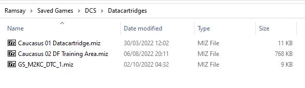
TL;DR: AFAIK dtc files are more flexible as they can store Offset Waypoints (BAD), etc. Using using the mission editor is simpler (just create a mission with a single M-2000C and set of way points). Detail The data cartridge is described on pages 276 - 277 of the current DCS M-2000C manual found in • "DCS World\Mods\Aircraft\M-2000C\Doc\DCS M-2000C Flight Manual EN.pdf" A data cartridge can be of 2 formats: • A .miz mission file with a single Mirage 2000C inside it, programmed with the desired flight plan/waypoints. • A .dtc data cartridge file in lua (lua is a programming language used by DCS) consisting of a few configuration variables and an array containing the flight plan. This is an example of the datacartridge folder structure for the Mirage
-
fixed Compass Rose stuck on top of F10 screen of NEVADA map.
Ramsay replied to GrafRotz's topic in Mission Editor Bugs
We are approaching the 12 month anniversary for this bug - is there any word of when we might see a fix or a way of placing the compass rose other than click and drag ? Tested DCS Open Beta Multi-thread 2.9.1.48335 -
Pretty much no single player missions anywhere for this map?
Ramsay replied to imacken's topic in South Atlantic
TL;DR: That standalone Missions for aircraft are made/included by the aircraft dev's - not the map makers. Detail: So the map installs includes for example - • DCS World > Mods > Terrains > Caucasus > MissionGenerator • DCS World > Mods > Terrains > Syria > MissionGenerator • DCS World > Mods > Terrains > Falklands > MissionGenerator While aircraft specific missions are created by each aircraft dev and installed with each aircraft module • DCS World > Mods > Aircraft > A-10C_2 > Missions > QuickStart -> A-10II_Caucasus.miz, A-10II_Nevada, A-10CII_Sinai, etc. etc. • DCS World > Mods > Aircraft > AH-64D > Missions > QuickStart -> AH-64D_Caucasus.miz, AH-64D_Nevada, AH-64D_Syria, etc. etc. • DCS World > Mods > Aircraft > F-15E > Missions > QuickStart -> F-15E_Caucasus.miz, F-15E_Nevada, F-15E_Sinai, F-15E_SouthAtlantic, etc. etc. A small map making team isn't forced or expected to make/test/support missions for each of DCS's +38 aircraft/helicopter - it's simply out of scope and unreasonable to do so. While more South Atlantic missions would be nice - there is nothing "forcing" any "aircraft" dev to add missions for every map, that is where user made missions and a willingness to learn/use the mission editor come in. -
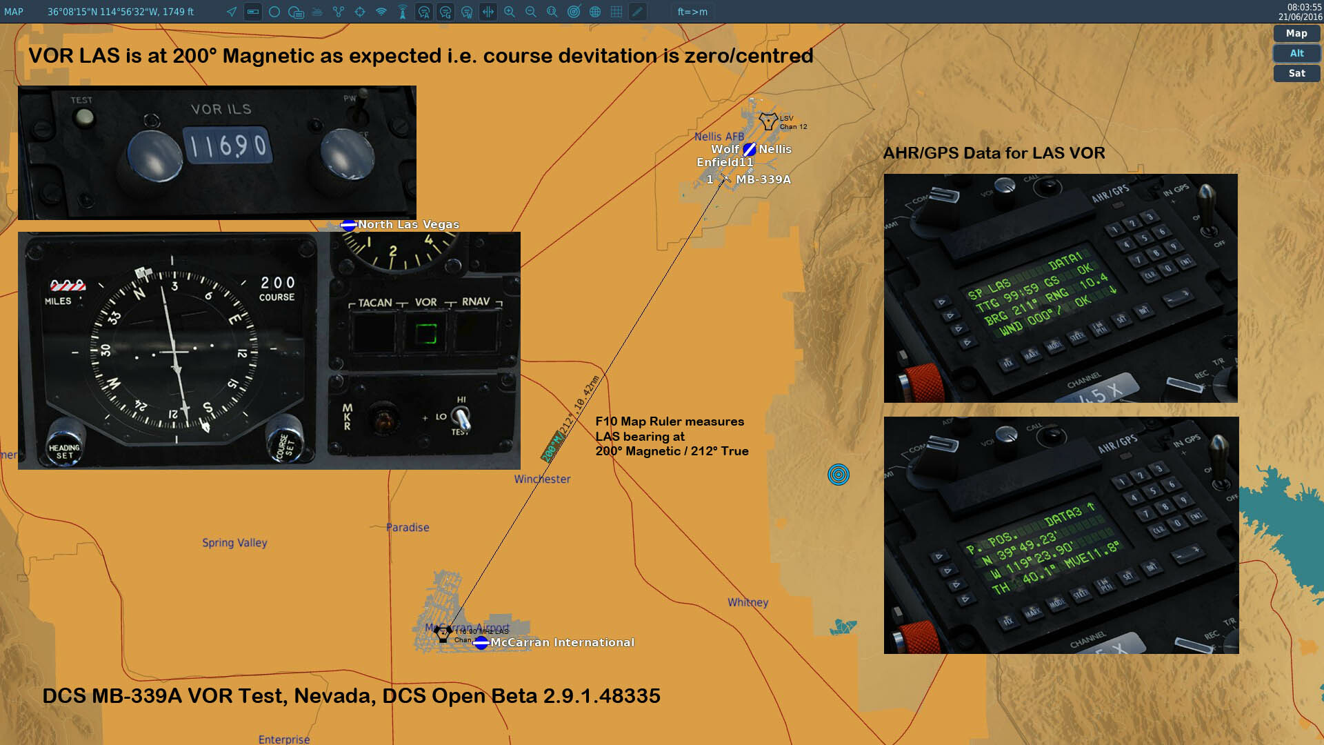
As said, I took time to test in both Caucasus and Nevada maps, I do not see an issue with the VOR HSI course deviation in the current Open Beta. I do see the problem with TACAN and RNAV i.e. using RNAV to LAS, I would set the HSI course to 212° to zero the deviation.
-
Current HSI behaviour in DCS Open Beta is that VOR HSI course setting references Magnetic and takes Mvar into account TACAN and RNAV HSI course settings reference TRUE The HSI compass card it's self displays Magnetic heading and the AHRS/GPS CDU TRUE Although the AHRS/GPS uses TRUE for it's internal calculations like an INS aligned to the rotation of the earth / TRUE North - it'd would make sense that Magnetic bearings are displayed to the pilot to be consistent with the HSI (magnetic) heading and information/signals i.e. Tacan/VOR radials usually reference magnetic North. However the exact MB-339A behaviour would need confirming with a SME. Tested in Caucasus and Nevada maps, DCS Open Beta Multi-thread 2.9.1.48335
-
The "general" date for GPS to function in DCS i.e. F/A-18C, etc. is March 24th 1994, IIRC the date of the last satellite. However, as you say and confirmed in the DCS F-15E Manual on page 271 So although there will be GPS for the JDAM to function, the INS of the aircraft "may" have an element of drift - time to test different mission dates I think.
-
The DCS F-15E JDAMs are WIP, the Smart Weapon data block "suggests" that the transferred co-ordinates (Sochi) and altitude (65 ft MSL) match the target location. As the OP's targets are at 5900ft MSL on the Nevada map - I'll need to test in SP to see if there is a guidance or HAT issue there.
-
Without a track or video - it's hard to know. Take a look at this GR video and see if you spot anything you may have missed (JDAMs are WIP and not all systems/modes are working). Perhaps recreate your issue in SP and share the track/video to help us, help you. The radar should be fine.