Ramsay
-
Posts
3750 -
Joined
-
Last visited
Content Type
Profiles
Forums
Events
Everything posted by Ramsay
-
This is NOT a bug - what you see modelled is a launch tube (the missile is carried inside).

-
IIRC ~80 KIAS for comfort and range (it's also approx. best autorotation speed for glide distance). 125 KIAS is the MAX VNE with crew doors fitted. • With weapons or a GTW above 4,500 lbs - VNE is 120 KIAS. • Without the doors - VNE is 110 KIAS = ~126 mph. No. AFAIK the fastest configuration would be to set the DCS Kiowa up as a Fort Rucker trainer (without weapons or the MMS) and was used in RL to train autorotations, etc.
-
Seemed ok when testing at Kobuleti (touch down point was about 1500 ft from start of runway), which airfield are you seeing this at ? Tested DCS 2.9.14.8394
-
The included training missions were created before changes were made to the avionics i.e. MFD display logic with RL limitations and a newer version of the TPOD/software. Unfortunately "M13: SENSORS AND TARGET DESIGNATION" is one of these - AFAIK most of the training missions were planned to be updated once a TDC designation "logic rework" was completed. However AFAIK the current ED/Razbam dispute has put all this on hold. Comment If looking to learn the current module, while not perfect (as they are a couple of years old), the best I can recommend (as a foundation) is • Chuck's AV-8B Guide along side an updated youtube guide such as • deephack's DCS AV8B Tutorial series or similar. Then if you have a particular issue i.e. dropping JDAMs, you can come back (to the forums) with a more specific request i.e. I've followed video xxx and can't designate, don't get HUD launch parameters, etc. with a screen shot(s) and/or a track file (to see if it's a know bug, limitation or procedural error).
-
Usually happens when the IR MAV isn't SOI (so slaves to the HUD flight path marker or target point/waypoint, etc.) - check the MFD reads IRMV, if not cycle the SSS or cage/uncage button as required until it does. If you continue to have issues please share a short track or video. Perhaps the tips in this old thread will help ?
-
The IRCM (disco ball, etc.) and L2MUM incompatibility is NOT a bug, I forget the exact details but IIRC the satellite antenna, etc. used by the L2MUM data link is fitted in the same location as the disco ball, so IRL an older Kiowa with IRCM cannot support L2MUM.
-
My guess is that it depends on your definition of "broken" i.e. the module has had "minor" issues since release (such as the HSI, GPS and TACAN using a mix of TRUE and MAG bearings) and it's taken IFE a long time to rectify them. DCS's 2023 multi-thread core update also broke some cockpit animations (i.e. canopy handle) that IFE retroactively "fixed". There's always been a minor bug(s) since I've owned the module, whether it be the gun sight mils or the current cold start ADI bug. However, to date, IFE have always found the resources/time to push fixes and the module continues to improve over time. Comment Although necessary to be patient for IFE's updates (i.e. the flight director, etc.), IMHO the MB-339 is definitely worth picking up in a sale (if looking for a modern/western trainer/COIN op platform). YMMV.
-
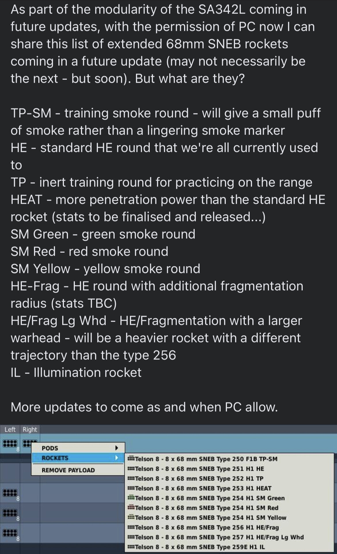
This list/description is from Polychop's discord around the time of the SNEB Rocket update
-
No, after the gunsight depression was changed, the old depression tables were removed from the in game kneeboard - however the training missions and DCS MB-339 Manual have yet to be updated (a known WIP issue) and still use the old (incorrect) values. AFAIK you should be looking for a depression setting ~140 mils at 30° Dive Angle, 400 KTAS, 3000' AGL This post has values based off the real aircraft which can be used as starting values in DCS.
-
mini stick very jumpy and imprecise on T pod and mavs.
Ramsay replied to silent one's topic in Problems and Bugs
I reduced the sensitivity of my Winwing's Mini-stick, sacrificing speed for better control, however I'm sure many players prefer faster slew rates. One thing to watch out for with the AV-8B is to include a centre dead zone as, if there is a residual slew input on one axis, it can/will stop the other axis responding (hence why an axis might "refuse to move at times"). The size of the required centre dead zone depends on how precise the mini-stick is in returning to it's centre position - for the mini-stick of my Winwing F-15EX Throttle, a value of +/- 2 is sufficient (OTOH an aging xbox controller requires a huge dead zone). YMMV
-
The DCS Gazelle's "Auto-hover / auto-collective" is an AI co-pilot "assist" for solo players and not a real feature. I'm not sure how accurate the DCS "auto-slave / slave to sight" is or even if it's a real feature.
-
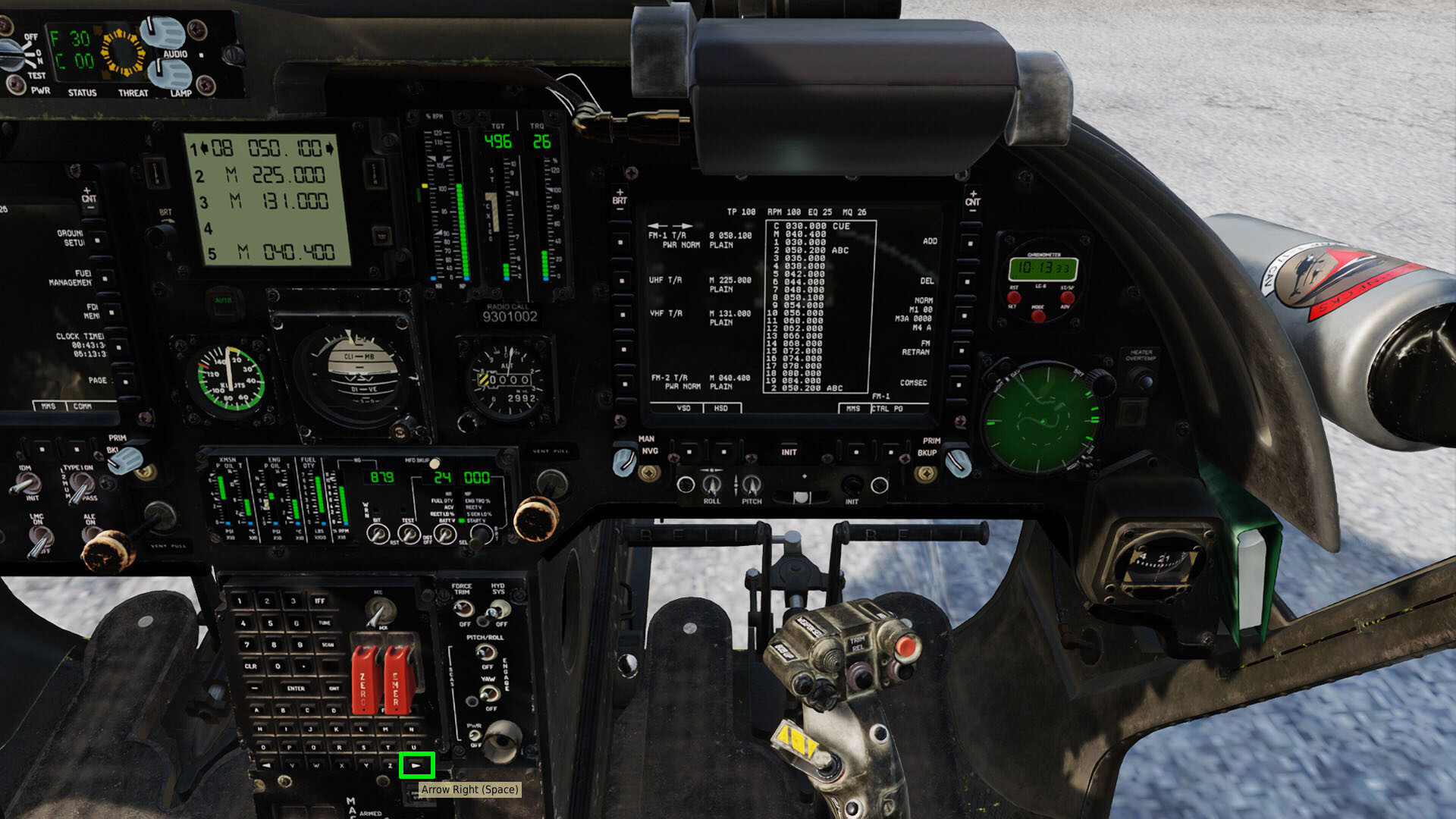
Unable to add/amend freqency using on board key pad
Ramsay replied to flyingscotsman's topic in DCS: OH-58 Kiowa
TL;DR: After typing the frequency [502] • use the MFK Right Arrow Key (adds a space at the end of the frequency digits) • then ENTER (fills in the missing zeros and moves cursor to the channel name field) • type channel name if desired • then ENTER Detail Your procedure to change/edit FM1 Channel 2 would be • ADD > 2 > ENTER • 502 > MFK Right Arrow > ENTER • ENTER Comment Using "MFK Right Arrow" after entering a frequency appears to be a "work around" for a DCS Kiowa bug, as the OH-58D Operators Manual (2001) makes no mention of it's use when adding or editing frequencies. OTOH it's also possible DCS is modelling newer avionics behaviour ? Tested DCS 2.9.11.4686
-
My understanding (from other games) is that it is a "tracking" radar and in practice is only enabled when a threat is "in range", otherwise it gives away it's position "early" and becomes vulnerable to weapons with longer ranges i.e. HARMs, etc. I assume DCS AI uses greatly simplified tactics compared to RL.
-
Master ARM can't enable.Stucked at STBY.
Ramsay replied to _UnknownCheater_'s topic in Bugs and Problems
Assuming you are trying to use the Master Arm Switch on your WinWing F15EX Throttle ? I have no issue assigning the Kiowa's Master Arm Switch positions once in the Kiowa cockpit i.e. ESC -> Controls -> OH-58D Pilot Note that the other Master Arm Switch options are for toggle switches or spring centring switches that have no centre position i.e. Switch Armed ELSE Standby. If you are using a different device/switch ? Please explain in detail how you've setup your controls. Tested using DCS 2.9.11.4686
-
TL;DR: Displayed distances KM and NM are tied to the coordinate system i.e. UTM or Lat/Long. Detail MFD > Initial Page L1 > Nav Align > R5 (Right side, Button 5) --> Select UTM for KM or Lat/Long for NM You can enter waypoints, etc. using UTM coordinates and switch to Lat/Long on the Nav Page to see the equivalent Lat/Long position and distance to waypoints, etc. in NM. AFAIK switching between NAV coordinate systems is none destructive to the underlying data, so • you could fly the ingress/egress portions of your route using Lat/Long seeing distances in NM •and switch to UTM to use MGRS coordinates, etc. once in the Operational Battlespace and supporting ground troops, etc.
-
This won't happen until the dispute between Razbam and ED is resolved. Razbam are unlikely to give ED permission to include their aircraft in any sales until they start receiving their share from sale of their modules i.e. Razbam and their coders/artists have been paid. An exception to this is the South Atlantic Map as it seems ED is passing on proceeds from sales of the map to Razbam ?
-
Have you used SSS depress "double tap" to switch to HTS mode prior to trying to control the TPOD ? It sounds as if you are still in the default SSS mode and haven't selected the HTS mode ? This post has Sensor Select Switch diagrams explaining the two sensor modes.
-
Because they weren't prototyped on a B and eventually fielded on a C variant.
-
The SA342 Module seems to have been disabled ? Have you 1. Verified the DCS install using Steam>Library>DCS World>Properties>Installed Files --> Verify integrity of game files 2. Moved/Renamed the "Saved Games\DCS" folder and tested letting DCS create a new folder (to confirm there isn't the remains of a mod causing an issue in saved games). 3. Uninstalled the SA342 DLC via Steam, removed the "steamapps\common\DCSWorld\Mods\aircraft\SA342" folder (if it remained ?) and then reinstalled via Steam (to ensure there are no user files/skins in the official install that fail the authorisation process) Failing all the above suggestions you *might* have to delete the Steam DCS World install and redownload the whole DCS World install to ensure the folder is clean of user mods that might cause issues.
-
The 1970 French SA-342 Manual (page 66) explains it is to prevent the entire loss of stabilisation in the event of a chain [channel ?] failure. Original text [FR] Goggle Translate
-
AFAIK the primary autopilot/SAS mode will attempt to maintain the set attitude (using the SAS pitch and roll channels) and heading (using the SAS yaw or roll channel). Speed and Altitude modes are "sub" modes of the primary mode using the pitch channel to maintain the selected parameter by adjusting the helicopter's pitch. AFAIK trim and autopilot/SCAS are interdependent, for example: heading is maintained with the SAS Yaw channel below 90 km/h IAS and switches to using the Roll channel when above 90 km/h IAS So all 3 SAS channels are used by the autopilot regardless of it's particular "mode", hence why disabling a single SAS channel, also disables the autopilot. I posted a diagram of the SA-342's Autopilot/SCAS in this thread, along with a link to a French 1970 SA342 Flight Manual (Section 1.7 describes the Autopilot on page 65).
-
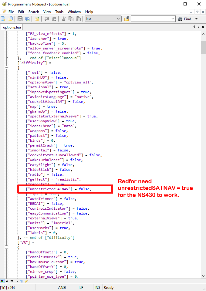
cannot reproduce NS430 doesn't recognize this map
Ramsay replied to YoYo's topic in Bugs and Problems
Your Mi-8 REDFOR Iraq mission works for me. Looking at the "options" file inside your "test.trk", unrestrictedSATNAV = false You will need to set unrestrictedSATNAV in DCS > Options > Gameplay to use the NS430 in a REDFOR coalition. Tested using DCS 2.9.10.4160 IIRC it does if the REDFOR coalition doesn't already include a nation (USA, etc. ?) that uses western (NATO ?) GPS. Either way "unrestrictedSATNAV = false" is the reason YoYo's NS430 isn't working in his Mi-8.
-
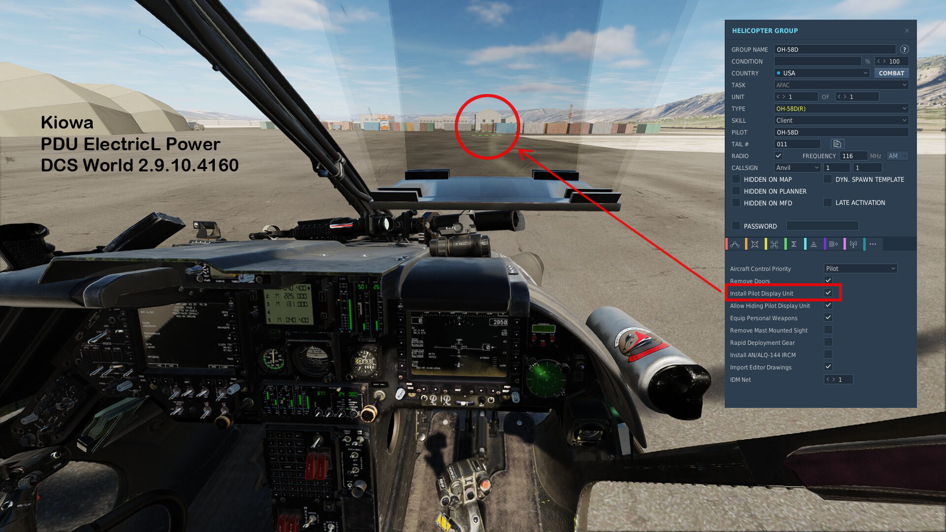
Pilot Display Unit (PDU) not showing any display
Ramsay replied to rocket302's topic in DCS: OH-58 Kiowa
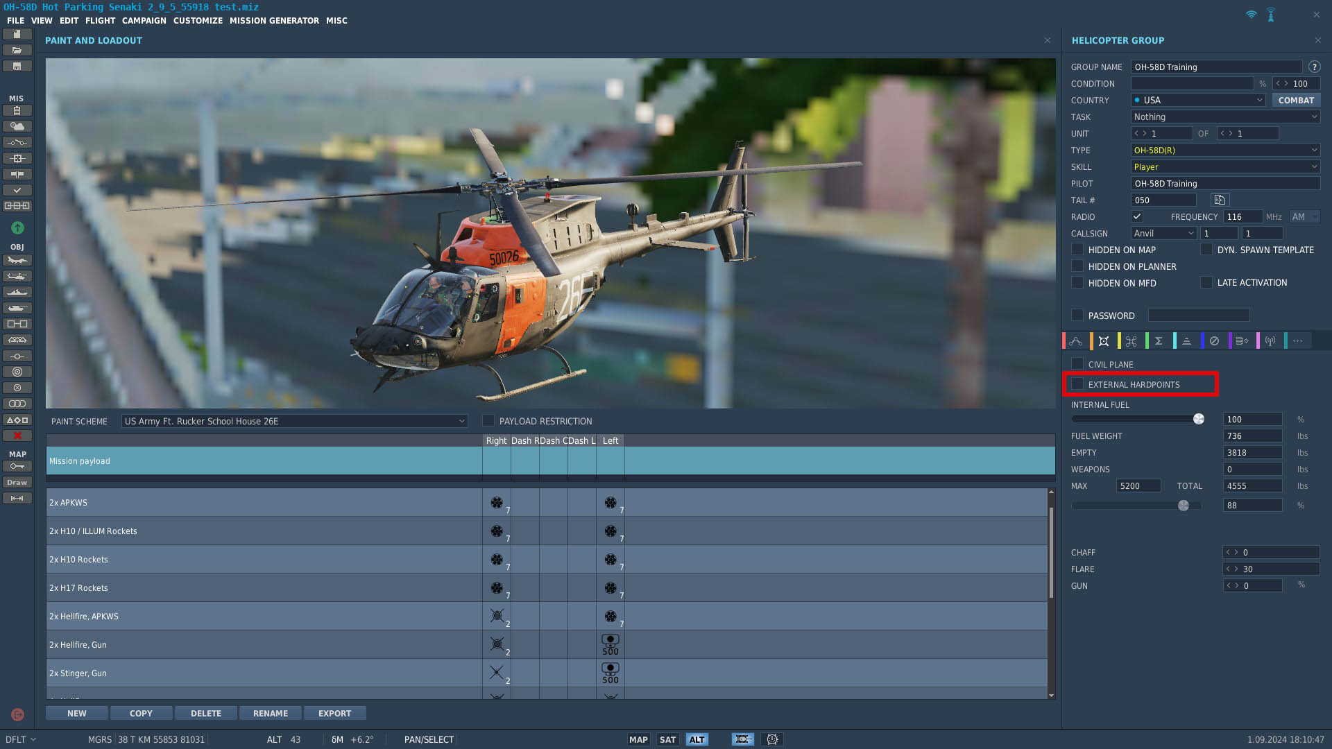
You MUST enable the Kiowa's PDU in the Mission Editor (it's off by default), otherwise the display does not work (the frame can be added/removed but will have no electrical power). Tested using DCS 2.9.10.4160
-
The AN/ALQ-144 is an older style IR Jammer ("disco ball" fitted on the KW's tail boom). It was effective against older types of IR missiles with a particular type of seeker head (AFAIK details are still classified). It was replaced on the KW by the newer CMWS, Countermeasures and L2MUM Antenna. The AN/ALQ-144 is available in DCS to allow mission makers to model older airframes - AFAIK there is no reason to choose it over the default CMWS.
-
Overweight aircraft handles hover with ease. The 1999 OH-58D Operators Manual "Hover Power Required (Figure 7-4)" chart gives an ~90% TQ estimate for a 230ft MSL / 7ft IGE Hover for the parameters shown in your screen shot (assuming a ~15°C FAT) - so the "in game" TQ looks correct. Originally the KW's max gross weight was 5500 lbs, this was later reduced to 5200 lbs to improve safety margins during autorotation, etc. https://discord.com/channels/303482672834019330/668295455863472188/695003287786881025