grim_reaper68
-
Posts
793 -
Joined
-
Last visited
Content Type
Profiles
Forums
Events
Everything posted by grim_reaper68
-
Hi new update today! from now the mod version will match the DCS version, so it will be easier to know if up yo date. Added BAT100/BAP120 to the CT but only on pylon 4 as IRL. OVGME friendly, just install in the root folder.
-
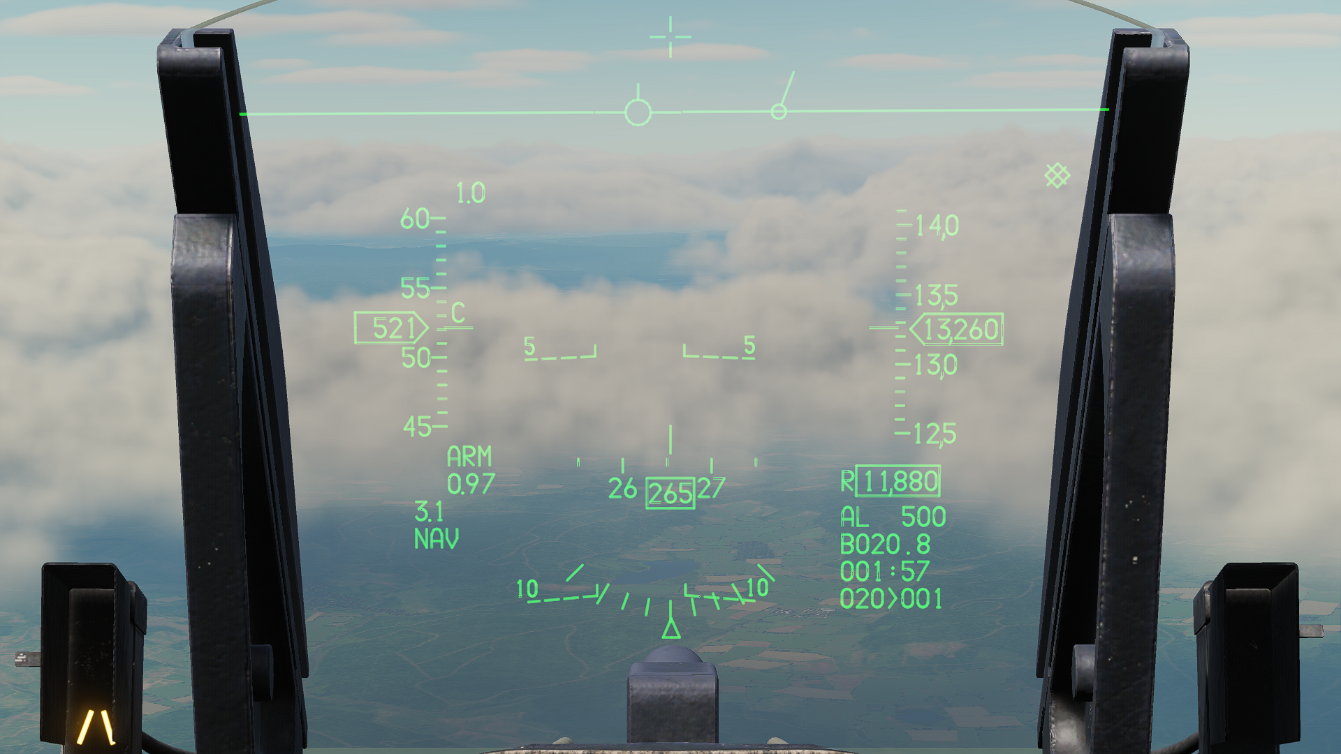
 Hi I noticed some problems with the HUD display since the 2.9.18.12722 release. As you can see there are some "holes" in the lines.
-
Military Assets for DCS by Currenthill
grim_reaper68 replied to currenthill's topic in Static/AI Mods for DCS World
Il y a déjà le french pack avec pas mal de véhicules, et pour les hélicos, il y a Damien qui en a fait. Certes ils ne sont pas parfaits (les hélicos), mais ont le mérite d'exister. There's already the French pack with quite a few vehicles, and for the helicopters, Damien made some. They're certainly not perfect (the helis), but they have the merit of existing. -
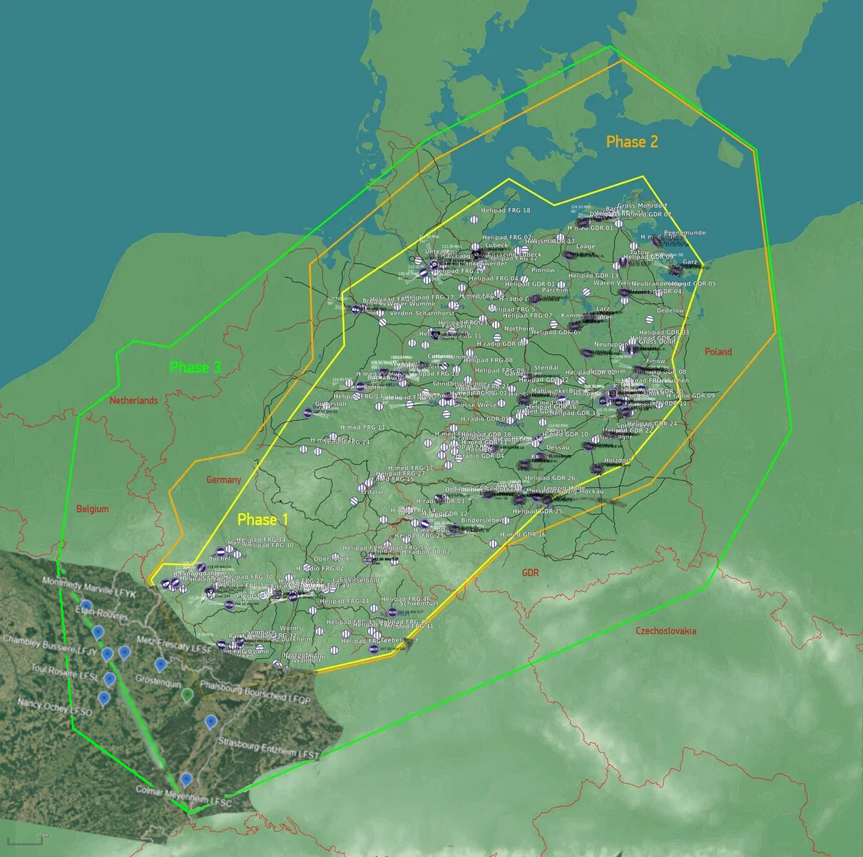
I would love to have this map in phase 3 is that map, as all those airfields were alive in the cold war period.
-
Or maybe is the Mirage F1 flaps logic done so.
-
Bonjour Une raison à celà? Edit: Pour les avoir à nouveau, j'ai du ajouter la section suivante. GT.tags = { "Carrier", }
-
Hi Did you try that? https://www.digitalcombatsimulator.com/fr/files/3332173/ Corail pods with chaff/flares.
-
Weather mod v2.0 for DCS
grim_reaper68 replied to bandit648's topic in Utility/Program Mods for DCS World
The weather button in the mission editor. A little cloud is drawn on it.- 540 replies
-
- 3
-

-
- thunderstorms
- rain
- (and 3 more)
-
Militariy Aircraft Mod
grim_reaper68 replied to BlackLibrary's topic in Flyable/Drivable Mods for DCS World
No, in my case the boom just travels from left to right, and never comes to the refueling port. only the KC-135 works. -
Foch and Clemenceau are broken... Edit: did you ever managed to land on the Clemenceau? I always exploded by touching the deck...
-
aoa light and altitude difference display
grim_reaper68 replied to wjmzwx's topic in Controller Questions and Bugs
Hi By turning the knob located just over the AOA indicator. For the altitude difference display, it depends. For the EE, it's located under the scope, on the right of the IDN,at the place of the RWR panel from the CE, it's the upper left knob marked EC. For the CE and BE, on the right console below the weapon panel, you have 5 rotators, the first on the left named EC.- 1 reply
-
- 1
-
-
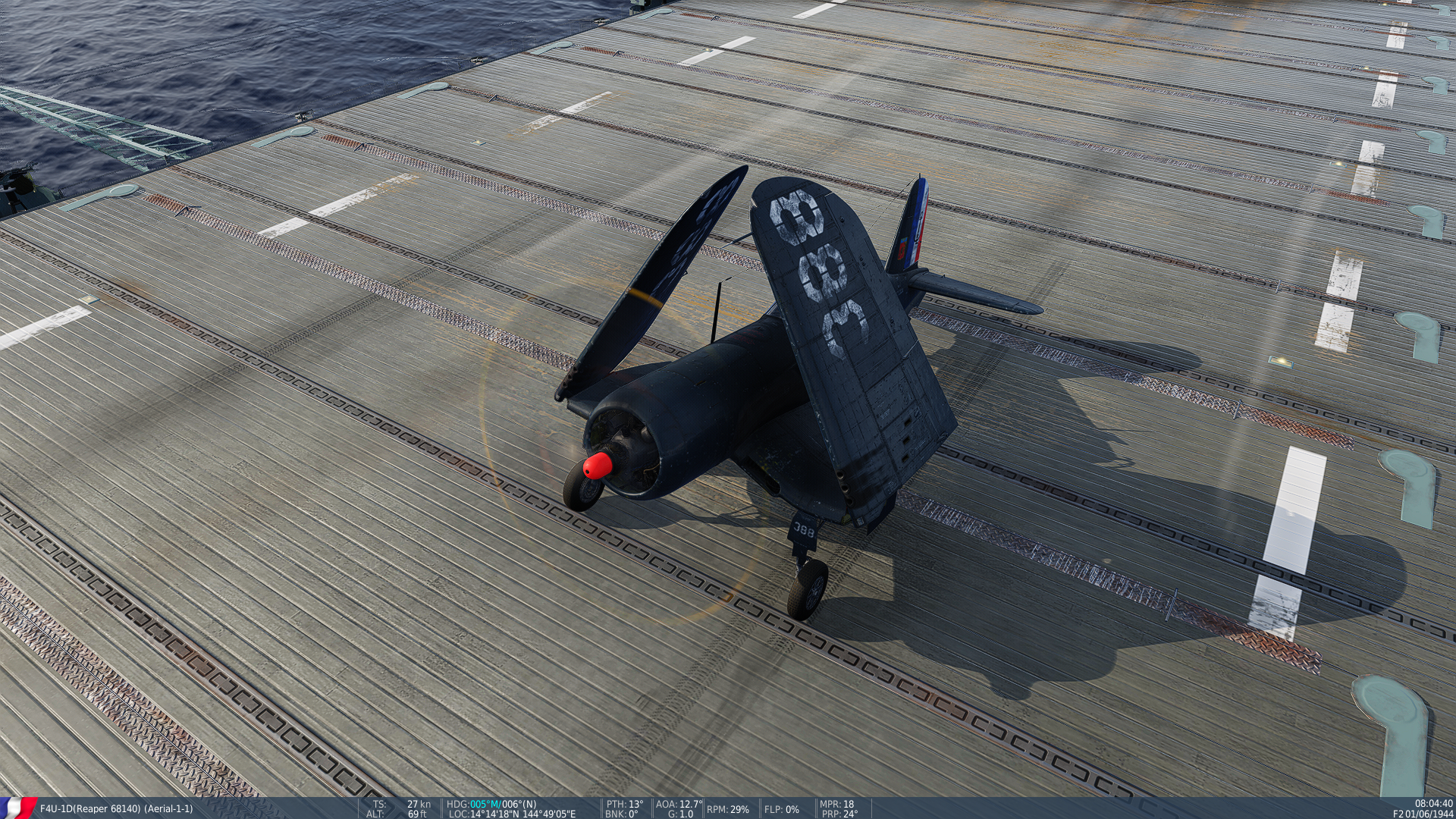
Hi I noticed that while the carrier was moving and with a wind at 20kts coming direct from front and the Corsair staying on thedeck, wingtips contrails will appear at 19kts TAS and it begins to move backwards at 25kts TAS. Maybe the moving back is correct and brakes should be applied. But the contrails appeared at the spread wings position, but in my case they were folded. F4U speed carrier bug.trk
-
Hi In the first post, the latest version should be 2.7.14, but the file is 2.7.10. Is it normal?
-
Ok, my bad. I thought it was part of the Mirage F1 weapons.
-
Hi I wonder where did you see the BAP100 in the weapons lua file? There is the JL100, and the JL100 is a combined fuel tank / rocket launcher, and was used on the Mirage III/V, and maybe on the F1 in some countries.
-
"Official" F-4E Livery Discussion
grim_reaper68 replied to LanceCriminal86's topic in DCS: F-4E Phantom
Hi just solved it, I had in the Saved Games folder DCS and DCS.Openbeta folder. Strangely DCS goes over to the Saved games DCS folder. I just moved the liveries folder from the openbeta one to the DCS, and everything goes fine. -
"Official" F-4E Livery Discussion
grim_reaper68 replied to LanceCriminal86's topic in DCS: F-4E Phantom
Hi, sorry to bother you, but, where should I insatl the liveries? I tried DCS saved games\Liveries\F-4E and F-4E-45MC, but I don't see them. -
I tested the takeoff setup from the video without catapult of course. While push the throttle slowly it's easy to take off from the carrier and needs only little correction on the rudder to keep the Corsair in a straight line. After leaving the carier, the corsair goes up by itself without any input. Bringing the flaps up is a little bit tricky as the Corsair goes up violently at each step. For the crash on the video, when I see how the elevator is set, it seems the pilot pulled it. I don't know if I can compare IRL and DCS Corsair, but in DCS only the trim tab moves, and not the elevator. In comparison to the other who take off, the elevator is very high.
-
Interesting video, I was surprised to see the trim and flaps setting in the video. They don't match with the DCS flight manual, where there is 1° nose up trim and 30°flaps for carrier takeoff. But I can suppose that it has to do with the fact that they are using the catapult in the video.
-
ASM-N-2 BAT won't reload in unlimited weapons
grim_reaper68 replied to grim_reaper68's topic in Bugs and Problems
I oversaw it, sorry. -
Hi I made a training mission with the BAT and it doesn't reload despite the unlimited weapons is checked.
-
Seems Pappy has got the 740, the 883 and the 86 number
-
Hi Could you please add Pappy Boyington liveries.
-
Hi The Tiny Tim rockets are missing in the training mission.
-
Hi I'm wondering why the devs aren't answering more about the bugs reported in the bug section? Or eventually here too? I can imagine that you have a lot to do, but a small message to say, ok we've saw that, and it will be taken in account in a further update, or something like that would be great. I didin't make some stats, but in the bugs and problems section most of the post seems even not to have been seen by the dev crew. I'm not complaining, as I can figure you guys have a lot to do. It's just a suggestion By the way, thanks for the great work you've already done, and all the work that will come in the future.
-
- 5
-