TJTAS
-
Posts
204 -
Joined
-
Last visited
Content Type
Profiles
Forums
Events
Everything posted by TJTAS
-
Why Was the Fulda Gap the Obvious Invasion Point?
TJTAS replied to Rex's topic in DCS: Cold War Germany
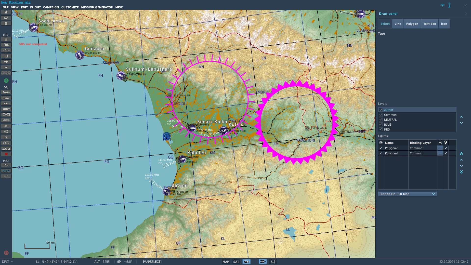
CWG_Historical_Primer.miz Here is a mission i made on the CW Germany map to outline the tactical importance of this map. You can turn the layers on and off through the draw menu (Draw button lower left icon). The Blue layer shows the Areas of responsibility of the various nations defending West Germany. This represents the mid 80s time frame of the map. Note they are Corps size (2-3 divisions ) The Neutral layer is another source i found for the National assignments. I believe this is either 60s or 70s. The Red Layer is the Soviet layer. The main dashed red lines marked with XXXX are the Army group boundaries with the Army group assignments in the rear. The orange arrows denote the low ground and armour friendly crossing points of the border. The light blue dashed lines are the important low ground routes into west Germany. The yellow arrows at the projected development of any attack. This is all based on US estimations in 1979 of the expected 7 Days to the Rhine plan. Now notice that the soviet units are all Army group sized. In the case of the 6th Guards Tank army this would have been 6-7 tank Divisions. This is truly massive. For the TO&E for soviet divisions in this time period please consult FM-100-2-3. Now these are just the backbone formations for the attack. The soviets didn't trust the DDR, Czech or Polish units to really fight if it came to it. It is likely therefore that these units would have been driven in front of the soviet formations (at gun point) to soak up ammunition. Add to this the lower echelon formations and the disposable units (Chechnya, Ukraine, Cossacks, white Russians) which would have been pushed forward in front of the major formations. In military doctrine you want to mass 3 to 1 to guarantee a victory, In Germany the soviets could have amassed 15 to 1 odds and local ratios of 30 to 1. So as to the why the low ground routes are important. The North German plain is too good of tank country, Especially for the defender. The rolling terrain would give excellent fields of fire for defending units to hit soviet formations in the open. The soviet doctrine for attack was to flow like water, or to put it another way thigmotaxis. This is the scuttling behaviour of mice, rats, cockroaches etc. Low ground routes give you the ability to scuttle through and if you hit a hard defence pound it with artillery (which the Soviets had a LOT of). This is a bit of a simplification, there are other factors going on like concentration through time (like ripples coming up a beach) but it covers the basics. -
Not sure if this has been mentioned before. I did search but couldn't find anything. The SA-13 shouldn't be using it's radar all the time like it does. The radar on this thing is *only* a range finding radar, not a search radar. It should only be used after the unit has visually identified it's target to establish range and closure to see if it is within the missile's engagement envelope. Currently all it does with the radar on by default is give its position away.
-
- 3
-

-
Yellow "urban" colour on F10 map includes fields
TJTAS replied to Flying Toaster's topic in Wish List
I just came to report this same issue. -
5+ years later and a patch just for campaigns and nothing to fix this one?.
-
thanks!
-
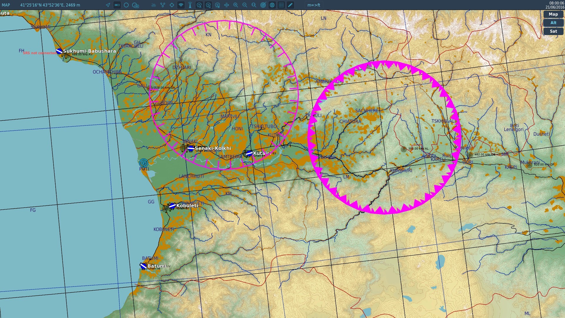
nullIn the mission. Graphics are correct. In the mission map view the orientation of the shapes is reversed and incorrect

-
Ok seems to be a general issue with disk and oval at least. Any border type which can have an obvious wrong way is reversing between mission editor and mission.
-
Someone from ED testing might want to have a look at the drawing / Graphics. Not sure if this is a general issue with graphics styles. In the case of creating a strongpoint disk / oval in the mission editor the radial lines are pointing out from the disk. When you run the mission the radial lines point inwards, incorrect.
-
DCS Super Hercules mod by Anubis
TJTAS replied to Eight Ball's topic in Flyable/Drivable Mods for DCS World
This mod doesn't seem to work on the Kola map. Specifically at the Norwegian airbases, Bodo, Banak and Kirkenes. You load into the cockpit and then DCS hangs. -
That's only because they don't leave the MG in the sponson unless it is in action. Unlike the 30mm the PKT is removable.
-
they all have it. It's the sponson on the right hand side of the gun (looking from the rear). In some photo's the mg itself may be missing but those are parade or display vehicles.
-
Sa-13 (Strela-10) has a ranging and attitude radar.
-
The BTR-82A in DCS doesn't have a machine gun. It should, it's in the housing on the right hand side of the main gun.
-
I honestly think this could be considered a bug. If you filter aircraft by type in the role selection screen then only those icons should be shown when you zoom in to an airbase. The current system is way too confusing. Especially when you zoom in to an airbase you reach a certain zoom level and suddenly get spammed with way too many overlapping icons. If not the alternative is maybe just have one icon for an aircraft type and then a number next to it in a list format.
- 1 reply
-
- 1
-
-
this is still an issue with this missile.
-
It would be really nice in the Payload restrictions UI if at the top it had just a tick box list of all weapon types for the aircraft. The current system of having to do it by pylon is ok if you want to limit items to a pylon. More often however i just want to remove a weapon entirely without having to go to each pylon option. A prime example of this is the AH-64, say i want to restrict it from having the L model Hellfire I have to visit a load of different pylon options. It would be much easier if I just had to tick one box (or un-tick).
-
Can anyone tell me how a map deals with time and the appropriate time zones?. It seems when you adjust the date time the location is listed in the dialog. This position seems somewhat arbitrary. The 2 I have looked at so far (Kola and SA maps) Kola has the time point set at one of the islands along the north coast The sun passes the meridian at 13:30 roughly Implying the map meridian is around 22 degrees east of this location. SA has its time origin in the sea between the Falkland islands and the coast of Chile. It's geographical location is -64 degrees longitude (about 4.3 hours east of prime meridian). Looking at the sun moon diagram the sun crosses the local meridian at 13:20 map time. Implying the map meridian is at -3 hours UTC(-45 degrees).
-
Any news on this?. Do you need any help with it??
-
Basically the gazelle smoke rockets last for a very short time compared to other smoke rockets in the game.
- 1 reply
-
- 1
-
-
If you need help with the decals let me know.
-
[MOOSE] Help with Moose Error - GetRandomVec2
TJTAS replied to Death Merchant's topic in Scripting Tips, Tricks & Issues
try making the zone a table {samZone} -
https://www.digitalcombatsimulator.com/en/files/3332090/ I've made the basic Euro 1 ( Charcoal Lizard ). You can use it for a base and add your own Decal to it.
-
Tried that, tried a different browser etc. I can upload fine to google drive, dropbox etc still a week later cannot get this file uploaded.
-
UPLOAD is the issue. The thread title is UPLOAD.
-
just keep getting this message