Ramsay
-
Posts
3750 -
Joined
-
Last visited
Content Type
Profiles
Forums
Events
Everything posted by Ramsay
-
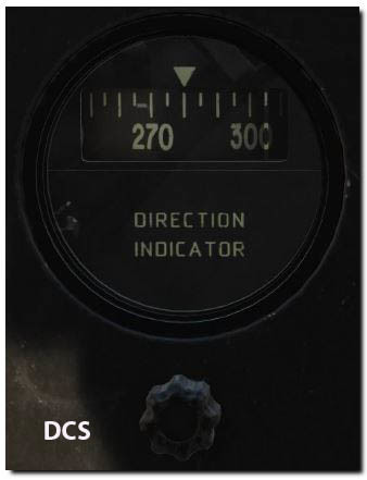
Mechanics of an early air driven DGI showing how/why the real scale is made increasing to the left. The scale is attached to the gyro mechanism which is stabilised in space/direction by the gyro, when the aircraft turns, the instrument window turns about the scale. Directional Gyro Indicator DGI | Directional Gyro Indicator Operation And Errors | Lecture 27 https://youtu.be/H8HjjOOYthw?t=78

-
A quick browse on the internet suggests the current DCS implementation is wrong but I'm no SME, so perhaps I'm missing something DCS (increasing to the right) Real (increasing to the left)
-
It certainly seems to have been rare, for example IIRC the use of 2x AN/TPN-30 for field carrier landing practice was mentioned in a Congressional Procurement Report, so looks to have been unusual from a budgeting point of view. The impression I have of the AN/TPN-30 is that it wouldn't meet "normal/civilian" certification requirements but that it didn't have to, it's strength was size and speed of setup, it's intended to help pilots find a temporary landing site at night or in poor visibility, not provide "precision" approaches. How the AN/TPN-22 was used IRL (i.e. in Iraq 2005) is harder to judge as, although it supports ICLS, it's a fully featured PAR and at a mixed traffic expeditionary airfield, it may make sense to standardise/restrict ATC to use generic (non-ICLS) procedures (except for special circumstances/training), There are a few AN/TPN-30 and AN/TPN-22 photo's on the Bogue Rats MATCALS site, although some look to be from "open days", http://boguerat.www4.50megs.com/Equipment.html I believe the idea was to train both USMC pilots and ATC in their setup, use and procedures prior to deployment, etc. AN/TPN-22 Automatic Carrier Landing System
-
Is your JF-17 Onspeed Caret Functioning ?
Ramsay replied to glen.a.williamson's topic in JF-17 Thunder
ΔT shows you to be +8:51 behind time, the speed caret is telling you to fly as fast as you can to get back on time. The ME shows a planned ETA of 21:04:07 at WP 1, while the HUD shows a time of 21:12:40 I think the only way you'll be able to fly to your current route timings is change to a runway spawn. -
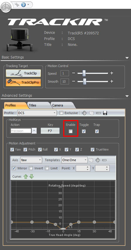
By default TrackIR uses the F7 key to toggle "Precision" mode and doesn't pass the key stroke on to DCS. I have "Precision" mode disabled but perhaps disabling "Trap" would work equally well, YMMV.
-
Precise or UTM Coordinate input for target waypoints??
Ramsay replied to AG-51_Razor's topic in Training Missions
No problem, I've uploaded a short tutorial/demo of entering AV-8B UTM Target Points, hopefully it'll help. -
Precise or UTM Coordinate input for target waypoints??
Ramsay replied to AG-51_Razor's topic in Training Missions
You need to have a waypoint or similar close to the target i.e. in the same UTM "block" So assuming you are entering the Target Point(s) while still at your base • Create a WP near the TGT's using Lat/Long. • Select this new WP and then enter Target Point(s) T1 to T10 using UTM for precise target co-ordinates. This is an example mission starting at Senaki to bomb targets at Tbilisi Unfortunately the track of this mission fails with the Harrier crashing into the ground after take off but it can serve to show the data entry process https://www.dropbox.com/s/e9hpb18synn8rfa/AV8B creating UTM TGT PTS at Tbilisi%2C 2_7_5_10869.trk?dl=0 At the moment, there doesn't seem to be away of dropping multiple JDAMs (with one press) unlike with the TPOD and TOO. -
Loving the new Mossie Monday Series. Well done.
Ramsay replied to Cowboy10uk's topic in DCS: Mosquito FB VI
To my untrained eye (from the Merlin 25 start up video) it looks like there's a cable drive shaft (running from the cam shaft) that drives a three phase ? tacho generator.
-
Loving the new Mossie Monday Series. Well done.
Ramsay replied to Cowboy10uk's topic in DCS: Mosquito FB VI
Can't say it's correct but this Periscope Films de Havilland video shows similar RPM gauge behaviour from a Whitley Mk.V ? bomber with Merlin 10 engines. -
Thanks, I confirm your report. Tested DCS 2.7.5.10869
-
The OP's issue looks similar to this TPOD initialization bug when using SSS "double tap" to go from DMT TV to the TPOD page (after TPOD rearming and it's not been used/loaded previously). Cycling the TPOD from OPER --> STBY --> OPER should fix his issue but we really need the OP to post a track demonstrating how he's getting the TPOD into it's uninitialized state.
-
F/A-18C DataLink - Is this the dumbest question ever?
Ramsay replied to Toni Carrera's topic in DCS: F/A-18C
No data link issue here in either map when testing in SP. The E3 AWACS @20,000ft was loosing contact with notching enemy flying at lower altitudes (15,000ft) but that's perhaps due to the recent radar changes or the geometry of the mission. In neither test did the AWACS callout a radio contract that wasn't also displayed on the Hornet's SA page etc. Tested using USA E3 vs Russian MiG-23 and Tu-142, Andersen and Sirri, DCS 2.7.5.10869 -
F/A-18C DataLink - Is this the dumbest question ever?
Ramsay replied to Toni Carrera's topic in DCS: F/A-18C
It does but it doesn't cover as broad a range of channels as some have suggested and it can be a bit of "pot luck" if it causes an issue. IIRC Ch 07-09 used to be problematic but that was a couple of years ago, now I have a "white list" of channels that I know don't cause problems, there was a list posted on the forums of channels to avoid but it never quite matched up with my experience in game. You'd soon know if there was an issue, as everything for the datalink would be setup correctly but no data received from the AWACS. As Ice Rhino made no mention of other aircraft/TACAN's in his mission, I'm assuming that isn't his issue but thought it worth mentioning as it's caught out a few mission makers. -
F/A-18C DataLink - Is this the dumbest question ever?
Ramsay replied to Toni Carrera's topic in DCS: F/A-18C
If still having issues getting the data-link to work, can you share the mission or a short track file. Note that as DCS doesn't model frequency "hopping", the data link can be "jammed" by certain tacan channels i.e. a poorly chosen tanker frequency, etc. that operates in the same range. -
Both Nevada (+12°E) and Caucasus (+6°E) have easterly magnetic variations, that is, in both regions a magnetic compass will point slightly West of true north and needs a +ve value added to it, to point to true north. MagVar = True - Magnetic i.e. • Batumi RWY 13 MagVar = 126°T - 120°M = +6°E • Nellis RWY 03R MagVar = 40°T - 28°M = +12°E The sign of MagVar is often confused in DCS as we often convert from the F10 map (True) to the cockpit (Magnetic) by subtracting the (positive) MagVar i.e. • Batumi RWY 13 Magnetic = True - MagVar = 126°T - (+6°E) = 126°T - 6° = 120°M With regards to the EHSD bug, it'd be useful if you could include a track demonstrating the problem. IIRC the DCS EHSD should display the course line correctly and heading/course in either Magnetic OR True depending on the chosen Mag/True mode. However it's possible UFC input still takes user input only as a TRUE heading, regardless of the selected compass mode.
-
Might be you, the A2A update is still WIP and hasn't dropped yet. Without a track, it's hard to know if you're complaining about already known bugs or something else. IMHO it's best to work with what we have and wait for the A2A rework (models different PRF's, radar modes, ground returns and a load of other stuff), it'll drop when it's done/ready.
-
F/A-18C DataLink - Is this the dumbest question ever?
Ramsay replied to Toni Carrera's topic in DCS: F/A-18C
This old mission still works, it uses Moose to spawn a couple of low skill AI F-5 or L-39 to practice. AWACS is on 251 MHz for bogie dope calls etc. -
You could try • Options > VR > Force IPD Distance, to scale the world. ... the higher the setting, the smaller the cockpit looks.
-
Yes, there are lies, damn lies and statistics. I can't speak about the graph but ED's claims have at times proved to be "selective" and should be verified by SME's. Just because a module is well received (i.e. Huey), it doesn't necessarily mean it's accurate. All I know is that that the Yak's "Options>Special>Rudder trim" adjustment hasn't worked since it's release and I'll judge ED by their actions, not claims.
-
Yeah, a real life owner passed feedback about the rudder (and landing), a month or so (Aug 2018) after it's open beta release . https://forums.eagle.ru/showthread.php?t=217349 Other than fixing the ADF and a few minor changes i.e. language support; AFAIK nothing else was done/revised. ED simply haven't devoted the resources, choosing to prioritise other projects and put the Yak-52 into maintenance mode i.e. so other updates and lighting changes don't break it.
-
You can select Russian subtitles and use settings > auto translate > English (or your preferred language). No it's more fundamental stuff. Paraphrasing as best I can (don't speak/read Russian) Testing the rudder - ... and it just goes on and on, but hey - if it looks like a Yak-52 and sounds like a Yak-52, it must be good ? Disclaimer: I enjoy the Yak for what it does but I haven't flown the real or used the DCS Yak-52 as a teaching aid, it does sound it could teach bad habits though.
-
DCS: de Havilland DH.98 Mosquito FB Mk VI Discussion
Ramsay replied to msalama's topic in DCS: Mosquito FB VI
AFIAK the Mosquito uses air brakes, overnight the air pressure leaks off, so when first starting, chocks need to be used. Once the air pressure has built up (No 1 engine has an air compressor), the air brakes/parking lock, could be used but for run ups, etc. it was common to use chocks. The Spitfire also uses air brakes and a engine driven compressor, although it may be fighter - AFAIK it also requires wheel chocks when first started. Note: I'm not very familiar with either aircraft outside of their "pilot notes" and wartime film footage, so you should check with SME's for definitive answers, etc. -
Yes, though like pre-start prop turning, a lot of things in DCS are glossed over / simplified. A "typical" Yak-52 start up Yak-52 cold starting at -3°C The Mosquito will have you calling to the ground crew to work an external "priming" pump to start each engine. I've no experience with aircraft but I've worked with several older engines from the 50's that required fuel squirted into their inlet manifolds as part of a normal starting procedure. IIRC most had a fuel tank above the engine and were gravity feed, but perhaps one of them *might* have used a hand pump (it's a long time ago, so I really can't be sure). Even today, products like "Easy Start" exist to assist cold weather starting
-
• With my first test flight, I saw the bug and was unable to launch the 530D's. • I exited the mission and added another Mirage with 530D and Magics in the ME (may have copy and pasted the aircraft, perhaps that added DB issue to the mission ?) • Sure enough, there was no issue when the Magics were loaded as well. • Watched the track files to see if they played back correctly, they did. • Exited DCS, restarted and checked that the bug was still there (DCS is sometimes "Magical"/frustrating), I was surprised to find the 530D's launched. • Retested the 1st track and took control to make sure I hadn't missed something obvious i.e. hadn't held the trigger long enough or something daft; nope there was definitely a arming/initialisation bug in that track. Uploaded the results/tracks to support your post and help Razbam confirm the issue.
-
Not sure why, the schematic shows the triple gauge is connected to main fuel line "main". Pumping fuel to the "cylinders" is pumping fuel directly into the inlet manifold, i.e. IRL after each pump stroke the prop is rotated half-a-turn, none of which would show on the triple gauge as line pressure. Whether a cold engine would start if the cylinders hadn't been "primed" is another question but we know the Yak-52 is missing it's failure modes ?