Aarnoman
-
Posts
380 -
Joined
-
Last visited
-
Days Won
1
Content Type
Profiles
Forums
Events
Everything posted by Aarnoman
-
Am aware, was just responding to the false narrative that this is due to an unfixable engine limitation, which gets thrown around a lot but is objectively incorrect as demonstrated by the issue not existing on Caucasus or PG. Thanks for bringing it to Ugra some weeks ago, I recall both threads discussing the water issue on the bug section.
-

fixed ALT Forests Layer covers important details
Aarnoman replied to Statua's topic in Bugs and Problems
Thirded, though at least in the recent Wags preview of Cyprus we can see the updated map layer, which demonstrated a different shade of green with clearly visible contour lines. I would hazard a guess that the Cyprus update at the earliest would be when we see this change brought to open beta. (seen here: https://youtu.be/MPBM8XHFWW8?t=87) -
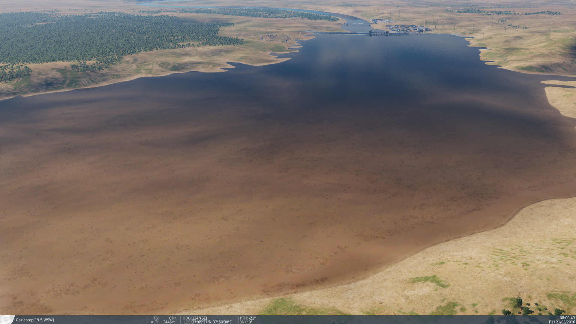
This is not correct. Please watch and compare the following two video demonstrations, one on PG and one on Syria, clearly showing this issue is ONLY present on Syria. Please stop the misinformation with "it's an engine issue etc". Persian Gulf: No water transparency issue: Syria: Water transparency issue present:
-
FRENCHPACK V4.9.1 Update on 27/04/2022
Aarnoman replied to dimitriov's topic in Utility/Program Mods for DCS World
I think you misunderstood me, I was asking whether your team would be open to adding some of these statics (specifically berm emplacement) to core DCS World (so the mod would not be required). You can apply to ED to have such models added to the base game. -
It is not an issue with the engine though, I don't understand why this incorrect information gets repeated so much. See here for comparison to Caucasus, where this issue is not present: This issue is unique to Syria, and does not happen on other maps including Caucasus and PG. It is not an engine limitation.
-
In full agreement. The main issue is not the visual quality of ground troops (though I would not be opposed to better looking infantry like in the recent whitepaper), but the lack of logic to detection/movement/attacking/embarking/disembarking. For one, it would be nice if vehicles by default carried a certain number of troops, that would dismount automatically when appropriate. Furthermore, as @Callsign112's videos demonstrated, the detection and engagement logic certainly needs more work. However, the constant throwing around of DCS as an FPS just seems silly to me - it misses even the most basic features for this, such as enterable structures. Moreover, the immense map size does not land itself well to an fps either, especially with the limited ground level detail. It would not add anything much of value while taking a significant time and cost investment on the part of developers. However, improved infantry logic/abilities (e.g. some degree of autonomy, appropriate use of stances, automatic embarking/disembarking, etc) with some level of control through combined arms (movement/objective logic) would be more than welcome, would significantly less work c.f. creating an FPS, and would add a significant amount to both combined arms and regular pilot's gameplay.
-
DCS infantry is really well done? I'm sorry, but what? In my experience the infantry we have currently available is anything but. They end up getting stuck in each other half the time, move in a conga line unless specifically micromanaged with multiple waypoints, and do not fight convincingly. Also, the models (apart from that one insurgent model) look straight out of a 2001 video game. This is coming from using infantry in DCS missions for many years, and they have continously been a source of frustration for me due to the degree of waypoint micromanaging required to make them look like a barely functioning squad. Heck, even something as sensible as embarking/disembarking infantry into a few APC's is nigh impossible in DCS.
-
FRENCHPACK V4.9.1 Update on 27/04/2022
Aarnoman replied to dimitriov's topic in Utility/Program Mods for DCS World
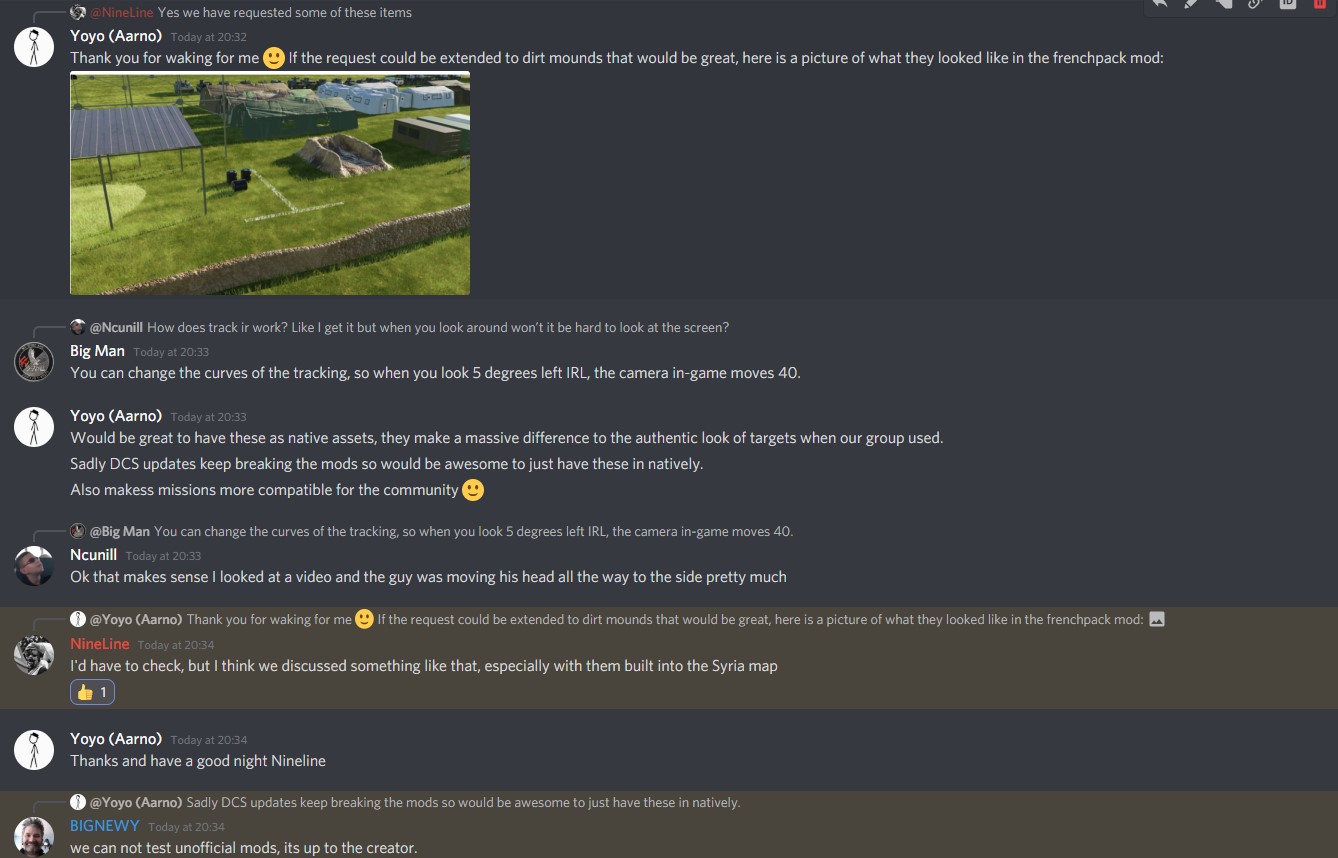
@dimitriov I have asked recently on the discord regarding adding statics like dirt mounds to DCS, as it is an important missing piece for current DCS defensive positions. See discussion here: I wonder if it would be possible to add some of the excellent static objects in the frenchpack mod to core DCS, so it can be used by everyone. It would be very nice to see things like the dirt mounds and other statics available, as it is often too difficult to get multiple people to have the same mods up to date (or mods break due to DCS updates), meaning that my group (like many others) avoid mods altogether as it causes too many issues. Many thanks for your consideration.
-
Please ask them to remove this entirely, there is literally zero reason to advertise another map in a game that strives for realism. It's honestly so infuriating and tacky and can't believe they still haven't done anything about it.
-
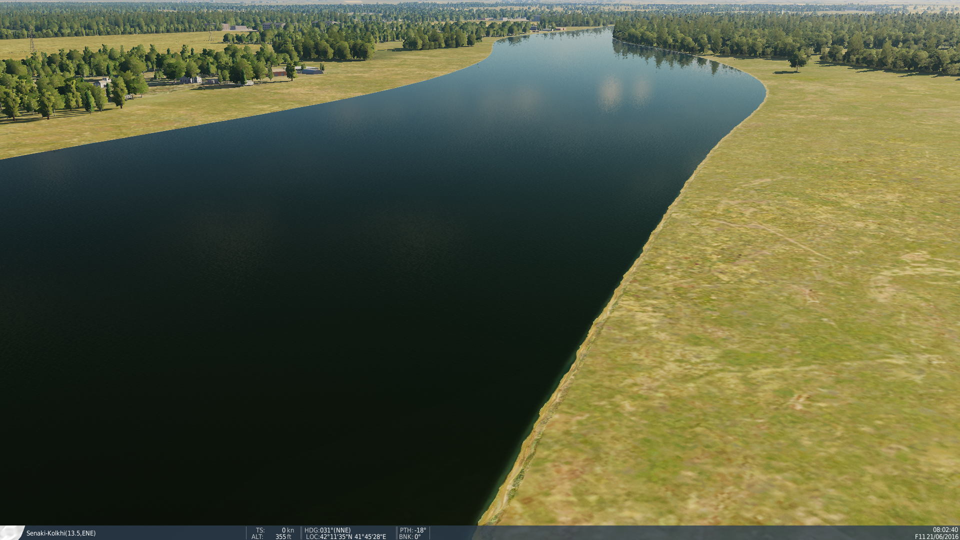
Video illustration. Notably, this does not occur on Caucasus (or other maps), as can be seen in this screenshot of the river in Batumi: Compared with Syria:
-
Video illustration. Notably, this does not occur on Caucasus (or other maps), as can be seen in this screenshot of the river in Batumi:
-
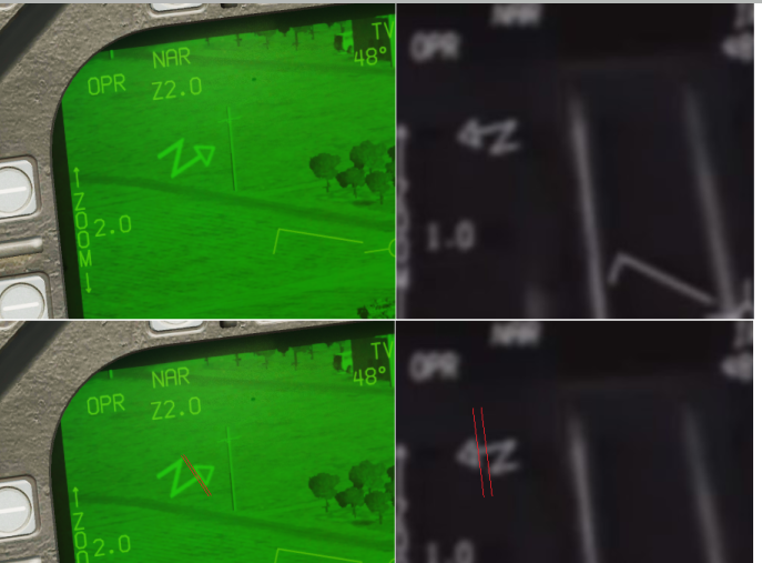
DCS Version: DCS 2.7.1.6430 Open Beta Bug: ATFLIR North Arrow symbology currently slightly incorrect. The arrow at present begins at the Apex of the "N", wheras the left hand upstroke of the "N" should in fact be extended, with the arrow beginning further up. Image illustration: Note the distance between the red arrows, demarkating the distance between the Apex of the "N", and the beginning of the triangular arrow symbology. Expected behaviour: As above, correction to be equivelant to real-world ATFLIR symbology. I recognise this is a minor issue in the symbology, but for the sake of accuracy it is important. Also excellent work updating the North Arrow Symbology to the (almost fully) correct symbology with todays update. See previous thread for further information:
-
It is not a global issue though, go fly in PG or Caucasus. No issue with the water like in Syria. Also, as shown with the pictures in the Mariana map, the coastline/water technology has gotten a significant update in the TDK (terrain development kit). These new features are also available to third parties according to BN, so it is up to Ugra to start utilising these to fix the issues with water in the Syria map.
-
@MAESTR0 Is Ugra planning to improvethe look of water in Syria? As shown by many users in this thread (as well as the bug threads in the bug sectio, and wishlist) the current implementation of water does not do the map justice, and makes the otherwise really well crafted terrain look very unrealistic. It would be very reassuring to hear that Ugra is planning to change the water shaders so rivers/lakes are no longer filled with crystal clear water, where we can always see the ground texture beneath the water and also causing artefacts such as the water changing colour from blue to brown when flying over a body of water. Thank you for reading and hope the team will work on improving this, it would really pull the map together having this adressed given the many areas of water features on the map, including the Sea of Galilee, the Mediterrainian coast, and the Euphrates river, among many smaller bodies of water.
-
Agreed. The water is a significant detractor from this great map.
-
Couldn't agree more, it's been one of the main lingering graphical issues in the map. Same with crystal clear rivers/lakes, where the colour changes from blue to brown as you get closer due to seeing the underlying ground texture. I hope water in DCS gets more opaque so this does not happen.
-
Too "glassy" and reflective water.
Aarnoman replied to Skysurfer's topic in Weather System Bugs & Problems
Agreed, the reflections are currently too strong, especially for clouds. -
Fully support this as well, would be very useful with the addition of road bases for all planes recently.
-
Too "glassy" and reflective water.
Aarnoman replied to Skysurfer's topic in Weather System Bugs & Problems
I think this graphical bug contributes largely to the odd looking water, particularly at distance, as it makes it appear closer to the observer than the nearby water: -
Version: 2.7.6.2659 (current OB 06/05/2021) Bug: Distant terrain reflections (and also cloud reflections) exhibit marching ants/dissolve effect with rapid changes in pixel contrast, and with very noticable blocky pixels. This is most noticable when high contrast elements (eg. dark terrain, white clouds) are close by, and the reflections dissolve into each other. Video example (watch full screen at 1080p to see more clearly): (Notice how water surface and reflections below the red marked area look very believable and realistic, however get more pixelated and blocky in distant areas). Expected behaviour: Reflections should be much more stable at distance instead of the rapid pixel changes seen currently. This is as the water is relatively flat in relation to the observer due to the large distance, resulting in a more stable reflection, without high contrast elements (clouds and terrain) dissolving into each other in the reflection. Image of what I mean by "marching ant"/dissolve effect: Think of white areas as clouds, and black areas as terrain. Notice how pixels of both dissolve into each others areas. This should not occur, as in real life it does not occur at the above distances as individual wave peaks are much smaller than a single pixel by multiple orders of magnitude at the above viewing angle. Steps to reproduce: 1) Water quality set to High in settings. 2) Position camera in a way where distant terrain can appropriately be reflected by a body of water. 3) Observe dissolve/marching ant effect in reflection.
-
- 1
-

-
Awesome work, looking forward to the Akrotiri teaser when you guys are ready for it!
-
Agreed, one of my pet peeves with this map due to the many bodies if water. The Euphrates river in particular looks consistently terrible due to switching from deep blue to mud brown depending on viewing angle/proximity, and is very immersion beaking.
-
Agreed, distant terrain looks very blurry and poor both in texture and shadow quality compared to other maps.
-
correct as is ground units - go to waypoint
Aarnoman replied to unknown's topic in Ground AI Bugs (Non-Combined Arms)
Can reproduce on latest open beta 2.7 -
Clouds rippling/boiling/jumping ect in 2D
Aarnoman replied to Alesia_Aisela's topic in 2D Video Bugs
That was it, I can see what you are talking about on the HD shots (though most gifs remain pretty subtle, but at least visible).