Aarnoman
-
Posts
380 -
Joined
-
Last visited
-
Days Won
1
Content Type
Profiles
Forums
Events
Everything posted by Aarnoman
-

Clouds rippling/boiling/jumping ect in 2D
Aarnoman replied to Alesia_Aisela's topic in 2D Video Bugs
I think the videos you linked are too low in resolution to demonstrate the effects well. I know they are real (I have witnessed them myself), but I am unable to see them clearly in your videos due to the low resolution/pixelation. -
No, you will have to wait until ED patches it.
-
Too "glassy" and reflective water.
Aarnoman replied to Skysurfer's topic in Weather System Bugs & Problems
Agreed. While there have been some good aspects of the change to the water shaders (e.g. wave size now seems appropriate, whereas before they looked far too large especially from very high altitude), more work is needed, particularly in toning down the reflectiveness. -
Absolutely, MSFS illustrated how much more 'character' flying has as a result of turbulence modelling in clouds.
-
+1
-
Well colour me silly I did not realize this was the case. I think it would be nice having it displayed in the mission editor icons regardless, as it allows easier comparison between presets at a glance.
-
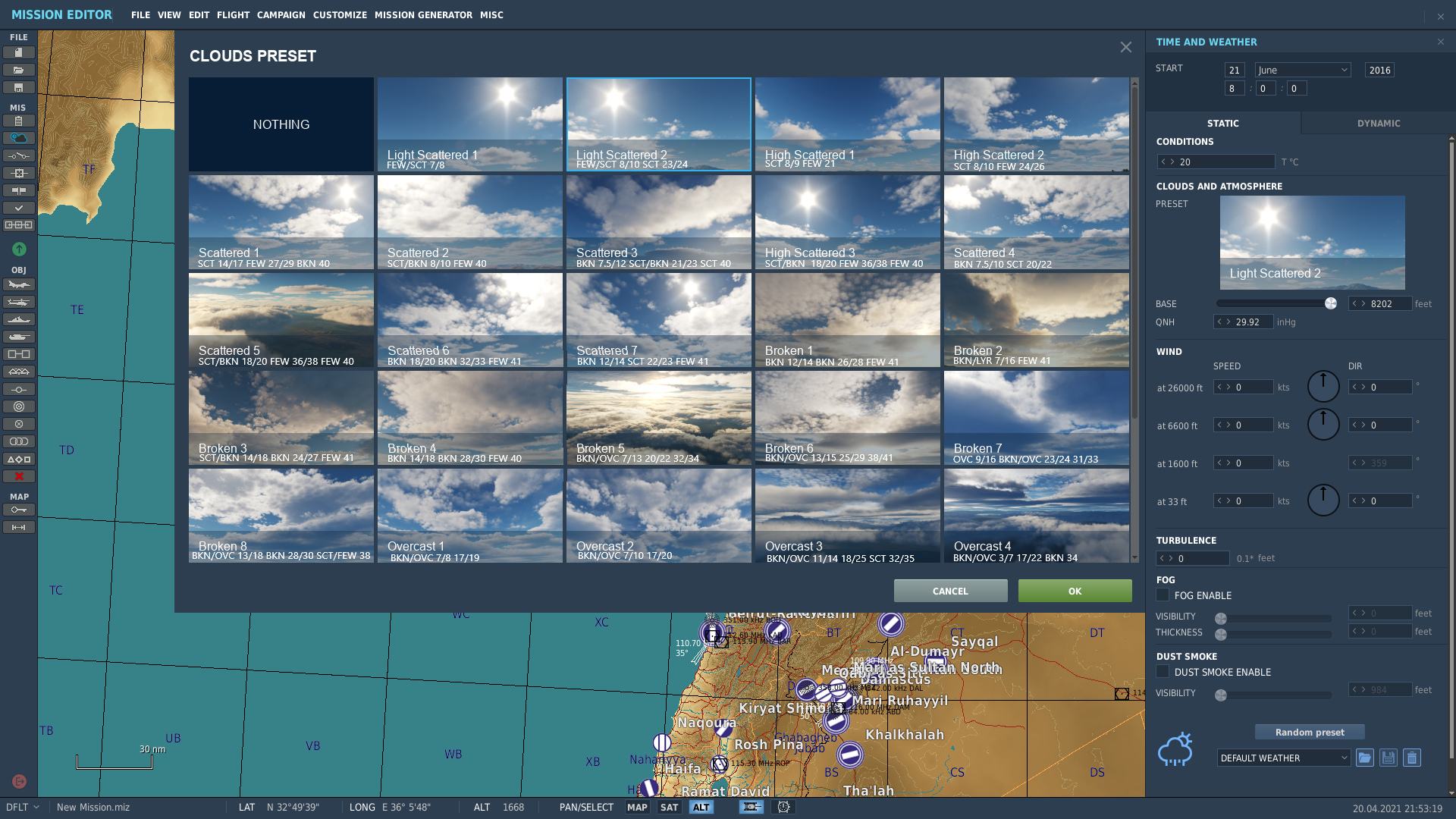
With the addition of many cloud presets with 2.7, one difficulty in use exist, particularly if further presets are added in the future: Most names (and images thereof) are fairly nondescript, i.e. "Scattered 1-7", "Broken 1-8", with an image that does not neccesarily represent the multiple layers accurately. I propose that METAR information is added to each preset icon. For example, Scattered 1 would have the additional descriptive text of "SCT 14/17 FEW 27/29 BKN 40" This tells us the preset has 3 layers: Scattered between 14000-17000 feet (covers 25-50% of sky surface). Few between 27000-29000 feet (covers 0-25% of sky surface). Broken at 40000 feet (covers 50-75% of sky surface). This would allow mission editors to be able to quickly glance at presets and identify those most likely appropriate for the mission. I would envisage the presets in the mission editor looking as follows (proof of concept): A full spreadsheet of all presets has been created by Sidekick, which looks as follows (reproduced as image with permission): Link to his video on clouds, which sparked this idea:

-
Clouds and rain don't move at the moment (they warp within themselves, but don't actually change location) so hopefully this will come in the future.
-
Water is too dark and horrible
Aarnoman replied to Fabiano-VIKING's topic in Weather System Bugs & Problems
The gamma is without a doubt set way too low in that screenshot. -
Awesome reference guide, well made!
-
+1
-
Indeed, the new water shaders do bring some improvement (e.g. sense of scale is better now that at high altitude individual waves are not really discernible anymore), however the lack of whitecaps and overreflectiveness of the surface can definitely be improved. Previously, whitecaps were definitely far too large from a high altitude giving the water the apperance it is much closer to the aircraft than it really is.
-
I completely agree. This thread has completely gone off course already anyway, with 4-5 different issues being discussed muddying the waters.
-
Map objects as asset objects in mission editor
Aarnoman replied to NakedSquirrel's topic in DCS Core Wish List
+1, so many great new assets that we can't use. -
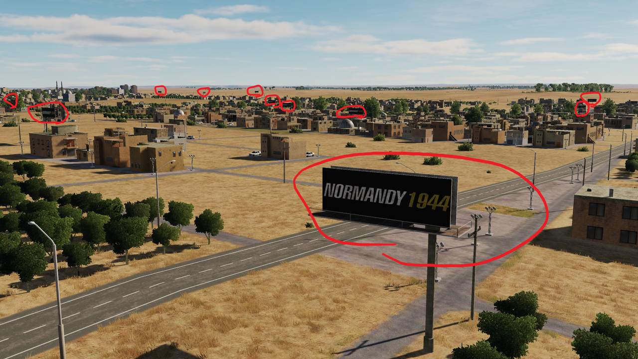
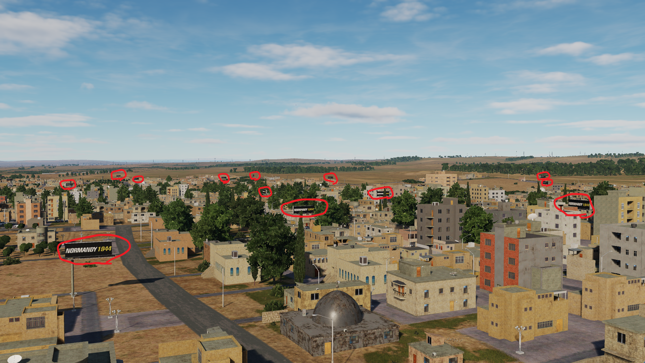
I would first like to congratulate Ugra on the many additions brought to Syria in 2.7, with the increased detail in Israel and border regions and additions of new airfiels being particularly notable. However, one change to the map has significantly lessened my enjoyment of the map, particularly in low level flight: The multitude of "Normandy 1944" billboards sprawled across every single settlement of the map. Example: These billboards were fun at first, but by the second heli flight they were simply annoying and immersion breaking. Can we please either have these billboards changed to Syria-appropriate banners that fit in with the world (and have some variety between them), or alternatively remove them altogether? Many thanks, Yoyo
- 25 replies
-
- 22
-

-

-
Yip, specifically this large thread: https://forums.eagle.ru/topic/267936-vr-quality-settings/
-
It seems in VR cloud settings default to low, whereas on flat screen the cloud settings apply correctly (low, medium, high, ultra). As a result, even when set to ultra in VR we currently get the 'low' preset for clouds. I believe ED is already aware of this after a few messages on reddit/discord.
-
Track file to reproduce? Have tried myself but had no issue Using GBU-12/Hornet, where accurate within a few feet.
-
System dependent, but overall performance increased in general for this map.
-
Well said. Absolutely not a gimmick and essential for accurate carrier simulation.
-
Option C.
-
reported Making forest overlay transparent for new maps?
Aarnoman replied to ghashpl's topic in DLC Map Wish List
Fantastic news. -
This is a different issue from the one described in this thread.
-
So much this. Would also be nice for infantry to be managable as squads as opposed to a bunch single vehicles in a group that pretend to be human not cars.