shu77
-
Posts
1689 -
Joined
-
Last visited
-
Days Won
6
Content Type
Profiles
Forums
Events
Everything posted by shu77
-
Having spent quite a bit of time looking at the coords and bearings There are some oddities in the Map data, a number of the runways numbers dont synch with their bearings, and I think there is a fairly substantial Magnetic variation. The Geographic Grid is also missing apart from the 2 degrees per square overlay which is why I havent applied a grid to any of my work and the MagVar is just listed as the current value for Incirik. The same can be said for Runway lengths where the values listed do no line up with the measured values in the mission editor, and in some cases elevation and GPS reference, which in a number of cases seems to be given as the Keys of the left hand field rather than a geographic centre of the field, again I have deviated from the listed values for most of the fields for that reason.
-

What do you use as a Collective?
shu77 replied to melchionda's topic in PC Hardware and Related Software
One of these An AliExpress USB Handbrake, drop the return spring out and add a 20mm diameter pipe as an extension. If you want to get really fancy you can build your own collective head, though a USB controller would suffice -
When viewing this field I noticed all the spots are marked with a H. Historically its the birthplace of the Lebanese Airforce, but I believe its now only used for rotary operations as the airfield was largely written off in 2006 by the Isrealis. https://military.wikia.org/wiki/Rayak_Air_Base So I believe its a helo base now.
-
Kiryat Shmona is reported in the F-10 map as a height of 238, in the mission editor it is consistently 328 the whole way along, looks like a simple transposition error in the airfield data.
-
Yeah definately happy to keep a copy incase it works in. Also interested in the RSBN info if you can share a screenshot as I'm not keen to buy the Mig21 just for that.
-
Hi Ike, in terms of RSBN, I had read Ugra were going to add RSBN so I was going to support those channels when added and put them into the summary data and diagrams themselves, but I think at the moment its just the Magnitude Nav data for the Mig21 which I cant see as I dont have MiG-21. In terms of Metric conversion, It requires a complete rewrite of every page so while this is an unofficial project I will probably wont do a metric chart, but will keep it in mind. If it helps, I specifically went with Nautical Miles as All the western Aircraft use knots and 300knts is 5 Nautical Miles a minute.
-
Have added Version 3.0 Airfield Diagrams Update to reflect frequency changes in 2.5.6.54046 Many thanks to Bailey for compiling these and giving me the heads up. There are some other changes to the map I will get in the next few days including a couple of runway changes, but I will be working through those once I get back into the sim. I thought you would all want current frequencies without having to shuffle documents. If you havent already done so check out Baileys awesome list of Frequencies which is the universal list for all maps. https://www.digitalcombatsimulator.com/en/files/3304548/
-
This thread explains it. https://forums.eagle.ru/showthread.php?t=252508&highlight=add+kneeboards+mission
-
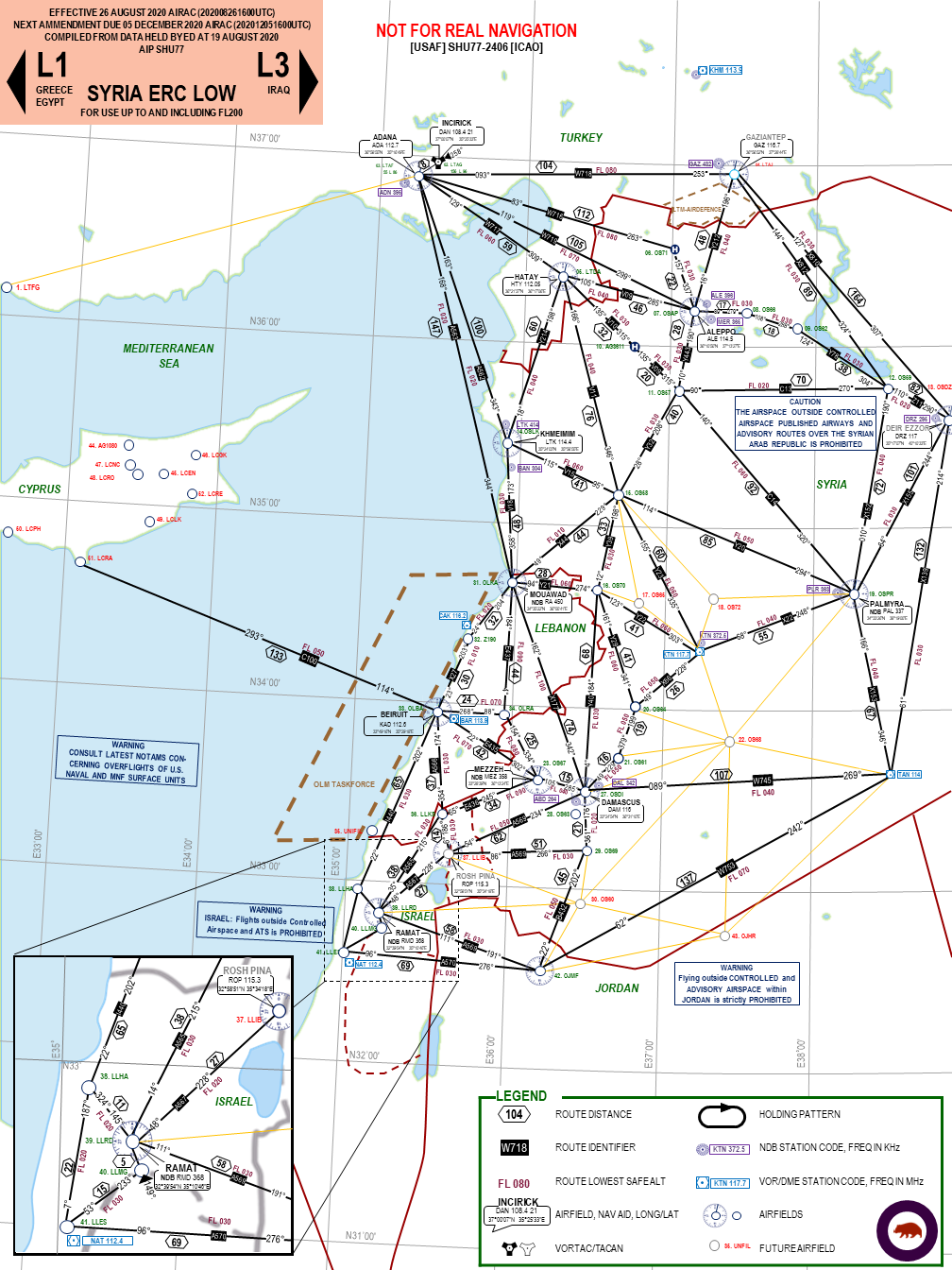
Enroute Chart now available on ED files HERE
-
ADMIRAL189'S CORNER - INCOMING SHIP MODELS
shu77 replied to Admiral189's topic in Static/AI Mods for DCS World
That one is cool! -
As the original response suggests there are Lots of Mods, but there are 'modifications' in terms of waht I call a Mesh substitution, and then 'Modules' which are fully realised stand alone aircraft with their own SFM or EFM. In addition to the ones YSIAD listed you also have: Predator Alphajet VNAO 'Readyroom' the AH-6J Littlebird (my personal favourite) and the Bell-47 which is based off the littlebird These are released as well as a number in various stages of development including an SU-57, a T-45, SU-17, SU-24, Kfir, Typhoon, Meteor. Most you can find in the last 3-4 pages of this forum or in the 3d Modelling sub forum.
-
As mentioned earlier the goal with the En-route Chart was to try and replicate the functionality of the old Caucasus IFR Charts while looking a little more like an aviation document. Originally I was going to post it into the knee-boards, but the amount of information makes it almost impossible to get it down to a knee-board format, so I will throw a copy of this into the next release but the document is best enjoyed at A3 or larger. As I sat and drew lines last night I had a few ideas from the first draft above. Even at this scale the Fonts are quite small though on the PDF you can zoom to read happily There are sites like Sky Vector that show IFR routes but they are limited in that they don't show military fields for the most part, and theirs not a lot of routes in the region due to the hostilities so not useful for planning a flight to some of the smaller fields, so while I based some of my work off them, I ended up blending styles and just connecting the dots to try and bring as many airfields into the Net as possible. This also presents some challenges as the size of the theatre where airfields blend together, and for that reason I dropped the Heliports from this release, though I may add Taftanaz and Minakh back at some point. While the previous example was zoomed onto the current map I have decided to publish the whole map with Cyprus even though there's no routes there yet, though if there's sufficient interest I can scale the document down to the mainland again, this actually takes more work to scale all the boxes back to suit. Where a field exists in real life but only exists in DCS as a Nav Aid I have coloured it Grey currently only Gaziantep though the VOR ROP in Israel is Rosh Pina LLIB so in the same boat. To be honest Israel is one of those examples where the amount of detail is hard to represent in a format that doesn't allow you to pinch zoom, and IRL this region would cover several Aviation Maps so there's limits to what I think can be represented. Theres also a few bugs, I'm not overly happy with how the software is anchoring the route lines to the airfields, but that takes a little work to address. Minimum route heights are roughed in based on terrain in the region, if you find one that is too low for ground clearance please let me know. I'll post the link the the PDF on user files once approved
-
Theres another thread running atm that suggests the issue is a bug with the map at present, so you either need to add the files to the aircraft or the mission. I am hoping its addressed with the next patch
-
I'll be adjusting the taxiway and Parking spots slightly with the next release though that may be when the next version of the map drops and I can do the Gridlines for each map and get a proper Magnetic variation. In the mean time I have been playing with the Layout for the Enroute chart and have attached the first cut. A copy has been uploaded to ED files and will be linked when released.
-
I think RSBN is confirmed as coming, I suspect we will see some updates on this shortly. Does anyone know what the airfield Icon for RSBN is?
-
Yes, there is a limitation with the map which doesnt seem to like Kneeboards, so you need to add them to the aircraft folder. I formatted the green ones specifically for VR night ops.
-
I prefer the square minimum size look/formfactor of the current one, but it would be better if it was "windowed" and moveable (TBH this would be nice for kneeboards as well which dont even seem to be adjustable via viewports atm) Bonus if you could adjust the translucency with a slider. Honestly the thing I want most is the ability to contextually reuse controls. I use the comms hat on the Warthog to manage radio selection in the hornet, per the actual layout so it would be nice if once the radio window was open I could reuse the same hat to navigate the menu. Theres a mod called DCSNav or there abouts that lets you do this but A) it needs its own hat switch and B) its an external app so the onscreen pointer doesnt consider the position of the text or the available options. If I could use the hat to browse the menu it would be great. I know I could drop some cash on voice attack, but it seems a very expensive solution to fix what is a pretty basic "quality of life" improvement to the system.
-
Honestly Syria is now the new standard for the game, awesome graphics, varied terrain, decent performance, extreme distances and dimensions, it really leaves the other maps behind.
-
I think this is because youre adding the kneeboards to an aircraft rather than the map. I think there may have been an issue with the capitalisation of .PNG on my first set of files but that should be corrected now, so you should just be able to drop the .png files into the same location and they will work
-
On the Warthog throttle or the MFDs? on the warthog LED0 is the back lights, you can turn that off then initialise the others separately. The code snippet below is my initialisation, except I make sure the Backlight is turned on and the others are turned off, then I tie turning them on the switch positions. ActKey(PULSE+KEYON+LED(&Throttle, LED_ONOFF, LED_CURRENT+LED0)); //set backlight on ActKey(PULSE+KEYON+LED(&Throttle, LED_ONOFF, LED_CURRENT-LED1)); //set LED 1 OFF GEAR ActKey(PULSE+KEYON+LED(&Throttle, LED_ONOFF, LED_CURRENT-LED2)); //set LED 2 OFF HOOK ActKey(PULSE+KEYON+LED(&Throttle, LED_ONOFF, LED_CURRENT-LED3)); //set LED 3 OFF SPEEDBRAKE ActKey(PULSE+KEYON+LED(&Throttle, LED_ONOFF, LED_CURRENT-LED4)); //set LED 4 OFF LIGHTS ActKey(PULSE+KEYON+LED(&Throttle, LED_ONOFF, LED_CURRENT-LED5)); //set LED 5 OFF PROBE Then I use a command like this to turn them on: MapKey(&Throttle, BSF, CHAIN(DX10,LED(&Throttle,LED_ONOFF,LED_CURRENT+LED3))); //LED 3 SPEEDBRAKE
-
https://forums.eagle.ru/showthread.php?t=284106 Worth looking at this forum thread, it suggests dropping your preload radius might help
-
Small mission showing off bit more of Syria map in Mi-8
shu77 replied to lankypilot77's topic in DCS: Syria Map
Hey Lanky, I was enjoying your video earlier today. Gave me some great pointers on places to go and explore off the airports. Keep up the good work! -
I've updated the file extension from .PNG to .png to assist with compatibility, although Im not sure from what Ive read this isnt implemented at a Map level.
-
That said I have updated the file format to be .png from .PNG to assist.
-
I suspect the issue is that Kneeboards are not implemented yet for the map, but if you add them to an Aircraft it will work. My understanding is DCS uses the Aircraft Kneeboards then the theatre then the Mission or vice versa. We've used the same file type/export process happily for missions on PG and Syria for Multiplayer so I dont believe its the file format.
