shu77
-
Posts
1689 -
Joined
-
Last visited
-
Days Won
6
Content Type
Profiles
Forums
Events
Everything posted by shu77
-
I really love this mod, thanks
-
Hey much tidier inside, Very nice effort!
-

[REPORTED]32 of 33 airports have conflicting runway lengths
shu77 replied to Bailey's topic in Bugs and Problems
My own review of this suggests that the data on the Airfield in the F-10 menu is static, and not linked to the values of the field, to Baileys point, the runway lengths differ significantly, and the elevations are inconsistently measured especially since these excellent fields all tend to vary in height. I think also the GPS position in a lot of cases seems to be mostly based on the location of the Western most Keys rather than the centre of the airfield. -
Still trying to decide how best to represent this in a diagram. Couple rough workings below for comment. I like the Idea of a Helo Supplement for this map.
-
What do you use as a Collective?
shu77 replied to melchionda's topic in PC Hardware and Related Software
My point was kind of that while you can put a shedload of effort into button boxes and 3d Printing, the Handbrake is actually a really good cheap solution if you are going to fly helicopters and I spent a lot of time during the build flying it with the pipe extension and no collective head so I can highly recommend that as a solution. -
What do you use as a Collective?
shu77 replied to melchionda's topic in PC Hardware and Related Software
The head is a 3d Print, I have a whole build thread in this folder on it, the pipe is 20mm garden 'poly' pipe, to a 15mm pipe which has a motorcycle throttle handle over it. -
Yeah Syria is not currently working for that atm, you need to add them to an aircraft to get them to show up, theres a long discussion on it above and in another thread in this forum. I've logged a bug, Im hoping it gets caught in the next update.
-
Thats pretty cool, though one observation I feel like the texture pattern on the tanks is too 'big' I think a finer texture would look more on point.
-
I was originally considering how to add them into the region chart on my map, or to add simple diagrams for them, maybe Enroute Supplement Style, https://www.airservicesaustralia.com/aip/current/ersa/FAC_YSHW_13AUG2020.pdf Will keep an eye on this thread and try and figure if theres a way to build them in or add a separate Helicopter Supplement.
-
These are cool, I was thinking about how to integrate them into the Enroute chart, I wish they were part of the core and the ATC function.
-
Logging it explicitly as the other thread doesnt seem to have made it in here, but Kneeboards placed into the terrain folder dont seem to be included when flying in Syria.
-
I used the handbrake sensor originally, but ended up connecting a Hal to the Leo Board. The twist throttle uses a motorbike throttle sleeve attached to a wire arm attached to the pot. The arm is a modified paperclip so that the post on the throttle sleeve can traverse the arm as it twists.
-
Yeah mate, theres a bug with the map it appears at present in hat it doesnt recognise kneeboards, try putting them under an aircraft for the time being, the bug is reported in this forum.
-
I'll add to this the Flight Global World Airforce database for 2020 which was where my reference came from https://www.flightglobal.com/reports/world-air-forces-2020/135665.article
-
Will see how much detail I can cram into the callout for UAE/Oman then. I've already lost one Nav Aid to get it that size, if I make it larger I will lose a couple more, but it is a difficult region to represent. On the Plus side it is a more complete map so I can start to add some more airfield data without too much risk of change
-
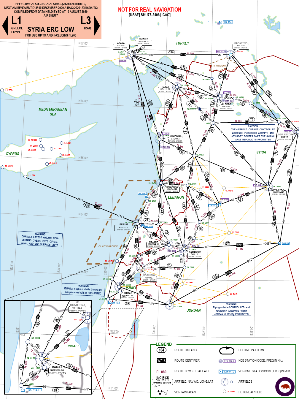
Technically just ERC Low, Theres not enough Air Traffic control to do IFR properly IMO, Have a look at the Syrian equivalent in my Sig, its really more bearings distances and Nav aids formatted to look vaguely like a chart., but they are an enjoyable Nav Aid to create.
-
I settled on 5.6E as of August 2020 per most websites for airfields in the region, though the USAF Incirick reference doc suggests maybe 6.5E, Im waiting until the map is more finished to do any proper measurements.
-
Still playing with the layout, one of the challenges with a chart like this is the volume of content in one area followed by large spaces and trying to keep to one page. Was thinking something like this:
-
Very helpful! Thanks
-
What do you use as a Collective?
shu77 replied to melchionda's topic in PC Hardware and Related Software
Honestly Ive said a few times I wish I had stopped at the handbrake with the pipe extension, dropping the spring out took 2 minutes and it was completely effective like that. When I mounted the collective head it added weight which meant I spent a lot more time getting the friction right and ultimately ended up adding a damper, which meant then adding a heavier duty mount to hold it static. If you just wan finer control for collective than a throttle lever without spending hundreds of Euros it is the way to go. -
1440p is: 2560 x 1440 This is very cool, Are you able to reference the 3 custom set ups with the monitor file?
-
Definitely agree about the MI-8, the World air force database suggests there are 2 x Syrian Mig 25s so they would be a bit of a rarity to see in the field!
-
So trying to decide on my next project, would you like to see an Enroute chart for PG or airfield diagrams for Normandy? I need something to keep me occupied until the next update.
-
So Cracked 500 downloads, thanks guys for the interest in my pet project.

