norman99
-
Posts
637 -
Joined
-
Last visited
Content Type
Profiles
Forums
Events
Everything posted by norman99
-
I’m currently flying some DCE missions, and having trouble contacting AWACS via voice. There’s 2 different AWACS in the mission, Overloard & Darkstar. I tune into the correct Overlord frequency, but when I make a request via voice, it always directs the transmission to the non existent Magic instead (identifiable by the pilot text). Even though the frequency is correct, because it’s directed to Magic, I never get a response. When I use the comm menu instead of voice, and select Overlord, it works correctly. Simply for ease of use, I usually omit the Overlord callsign in my voice transmission, but even including it makes no difference. I assume this is user error, but I just can’t figure out what I’m doing wrong. Any help would be greatly appreciated.
-
 +1 for single AMRAAM rails. Regardless of the ‘it’s not correct for our block/service’ argument, just having something between x2 fuselage mounts, and the completely unrealistic SPAMRAAM load out would be nice. Liberties on realism are taken all throughout DCS, single rail AMRAAM launchers wouldn’t even make the top 50 most significant of the Hornet alone.
 -
I’d just like to reiterate that more than 18 months after the OP, this is till a huge problem, especially for those who predominantly fly SP. Not only is it immensely annoying, it basically makes make any control over your wingmen impossible, as you simply can’t get a word in until they’ve finished. I know AI/comms is getting improved, we’ve been told that for years, but at what point will we start to see some actual progress? (User edits to .lua files should not be considered a viable solution by the ED devs.)
-
Exactly as the title describes, after landing on the carrier, when pressing the NWS switch to engage NWS Hi, the attack radar bugs the nearest aircraft as the L&S target. It also happens during startup, when attempting to engage NSW Hi, even when the radar has been in Silent mode, which is strange, because the only track files would be from datalink, and we cannot yet bug datalink files as L&S, so something is weird. I couldn't get a track, but I'll try and set up a small test mission to demonstrate.
-
Well, this mission didn't exactly go to plan.... Mission 1 - July 6, 2003 (H+1), 08:39 ------------------------------------- You have been tasked with escorting a strike against EWR 1. The target has been hit and sustained 100% damage. EWR 1 has been completely destroyed. EWR 1 (0%) - EWR 1 Radar (destroyed)(+) - EWR 1 CP (destroyed)(+) Your package has scored 3 air-air kills while sustaining 11 losses. Package: Callsign Type Task Kills Air Kills Ground Kills Ship Lost Ford61 AV8BNA Strike 1 0 0 1 Ford62 AV8BNA Strike 0 1 0 1 Ford63 AV8BNA Strike 0 1 0 1 Ford64 AV8BNA Strike 0 0 0 1 Chevy91 FA-18C_hornet Escort 0 0 0 0 (Player) Chevy92 FA-18C_hornet Escort 0 0 0 1 Chevy93 FA-18C_hornet Escort 0 0 0 1 Chevy94 FA-18C_hornet Escort 0 0 0 1 Chevy11 FA-18C_hornet Escort 0 0 0 1 Chevy12 FA-18C_hornet Escort 0 0 0 1 Chevy13 FA-18C_hornet Escort 2 0 0 1 Chevy14 FA-18C_hornet Escort 0 0 0 1
-
Have you ever heard of sound flight planning, non precision approaches, circling approaches, alternate minimums etc? It may surprise you, but in some places it’s actually possible to obtain an instrument rating (IR) without being endorsed/approved to fly ILS approaches. My first real world IR didn’t include GPS or ILS approaches; the first because the aircraft wasn’t fitted with one, and the second because there wasn’t an ILS nearby to fly during the test flight. Granted these are civilian terms/concepts, but military’s have their equivalents. In a nutshell, IFR ≠ ILS. I have a genuine question, have you ever flown a real aircraft yourself? I ask because you refuse to listen to people in this thread that are real world pilots, some of which even have substantial experience on real F/A-18s. Why on earth would you assume you have more knowledge then they do?
-
Sorry, I don't think I was clear, I had the problem first, and then completed the update afterwards. I haven't yet had a chance to test it.
-
On a separate note, I'm getting the following error after mission completion using the Crisis in PG-Hornet-CVN Campaign. F:\- DCS -\DCS World\bin\luae.exe: ../../../ScriptsMod.NG/UTIL_Functions.lua:956: bad argument #1 to 'pairs' (table expected, got nil) stack traceback: [C]: in function 'pairs' ../../../ScriptsMod.NG/UTIL_Functions.lua:956: in function 'CheckCodeLoadout' ../../../ScriptsMod.NG/UTIL_Functions.lua:986: in main chunk [C]: in function 'dofile' ..\..\..\ScriptsMod.NG\DEBRIEF_Master.lua:68: in main chunk [C]: ? EDIT: Just updated the ScriptsMod.NG folder to v 20.53.188, hopefully that fixed the problem.
-
Up until now, I've had absolutely no interest in the much talked about AirBoss feature. As primarily a single player user, it just never seems all that useful to me, but you've just come up with a brilliant idea. Allow the AirBoss the have access to a "launch que", with the ability to change both the order of launches, and the desired catapult.
-
With the glacial speed of SupperCarrier bug fixes and feature development, enabling the ability to reload the USS_Nimitz_RunwaysAndRoutes.lua mid game is even more beneficial. Lots of issues currently experienced by users, such as spawning damage, taxi gridlock, etc could be improved by users whilst we all wait for permanent fixes from ED. Furthermore, this would present mission builders with a host of new possibilities based on different deck configurations.
-
@Jackjack171 Yeah, I assume the 24 hour CAP would only be for a combat, high threat scenario, rather than a "normal", non combat deployment.
-
Hi Miguel, attached is my simple fuel check script. Just a word of warning, I'm pretty raw at coding, so it may not be the most elegant solution, nor have I haven't carried out any real bug testing. None the less, it works well for me in single player, especially when using VIACOM and adding a "Fuel Check" voice command. One day I may get around to adding an audio response in addition to the text output currently used. Cheers. EDIT: In addition to the above, I just remembered it's only calibrated to the Hornet, as I don't fly other aircraft. As DCS reports fuel as a % of max, I've simply converted this to a quantity value based on the Hornet's tank capacity. Fuel Check.lua
-
reported TK PRES LO above 20k feet with empty centerline tank
norman99 replied to Nealius's topic in Bugs and Problems
Does the centreline tank have to be empty? 3 full tanks, takeoff, full burner climb to 30k, and I hear it passing 20k too. Happens on the way back down as well. -
I've a small question. I have a small script which adds a fuel check radio call to the F10 menu, to which any aircraft in the players group respond with their fuel state (currently via text output only). It's great to keep an eye on the AI, and send them to the tanker or RTB early enough that they don't just bingo and eject. I usually add this to any mission I play. If I add my script to the base .miz file in a campaigns inuit folder, will this then be included in all the subsequently generated missions? If this won't work, I assume I can add a line to one of the scripts to add it to generated missions, I'm just not sure which one.
-
F/A-18C Dynamic Campaign: Battle Group Delta
norman99 replied to MBot's topic in Missions and Campaigns
Just curious if anyone has managed to get this campaign working with 2.7? I'm aware of CEF's great campaigns, and his DCE manager, but I've always enjoyed this campaign too, and would love to try it again if possible. -
This is absolutely fantastic! A much needed feature, I can't wait to try it.
-
reported Aircraft ID not showing on SA format.
norman99 replied to Hulkbust44's topic in Bugs and Problems
I've noticed this too. I get aircraft type in the HMD all the time, yet nothing on the SA page. -
Hi all, not sure if this is the best place to ask it, but as it has to do with cyclic ops, hopefully someone here can help. I'm curious how CAP flights would be scheduled in a hypothetical scenario where constant coverage is required, and how that integrates with the cyclic ops of the carrier. Given an example CAP flight of F-14s 100nm from the carrier, average 450kts TAS for transiting aircraft, gives a 12-14min transit time. When swapping flights at the completion of the desired station time, this means 24-28min from the launch of the replacement flight, to the arrival at the carrier of the airborne CAP flight, if constant coverage is desired. Assuming an 'average' carrier cycle event is 10-15min for launching aircraft and similar for landing, is it as simple as launching the relief CAP flight first, with the returning CAP flight arriving at the carrier just as recovery is finishing, being the last aircraft to land? I ask this because most references make mention of arriving aircraft ensuring they are already in the marshall stack at recovery time (ideally 10min early), and that late arrivals should be avoided. Alternatively, would CAP aircraft be launched early, prior to the cyclic event actually starting, in a similar fashion to E2s and tankers? This would allow the returning CAP flight to arrive back at the carrier earlier, though most likely still after recoveries have commenced. They'd therefore again have to join the top of the stack and would be last to land. Lastly, am I just overthinking things completely? Do all flights just stick to the scheduled event times, and small gaps in CAP coverage whilst flights are inbound/outbound are accepted to ensure the rest of the system runs to plan? Any details would be greatly appreciated. Cheers.
-
Re-raising this bug. If you shut down the left engine, then lower the flaps to full, which is the correct procedure from NATOPS, the left LEF becomes stuck at 12 upon startup. Nothing will fix it. Could this please be moved to the bug section so it doesn’t get lost. Edit: After double checking, flaps should be selected to full BEFORE engine shut.
-
Oh ok, thanks for the background. I understand the logic behind it being somewhat realistic, but it can’t be to the extent that is currently experienced. Aircraft basically facing 90° from me, 100nm away causing a launch warning in my aircraft that is parked on the carrier deck just doesn’t seem right. If attempting to operate realistically, and therefore treat launch warnings as real (even when you kinda know it’s not), it just constantly ruins missions as you have to react accordingly. The other option is to view enemy aircraft on the F10 map an check it’s a false warning. Such an immersion killer. Seems like it’s a challenge to fix, but I’m really surprised there isn’t more noise made about this issue. Anyway, seems enough was said in the previous thread, so I’ll leave it be for now. Maybe if we come back in another 3 years things may have improved….
-
Absolutely love this mod! One question though, has anyone used it to create some templates of SAM sites? Personally I’m interested in the older Soviet systems (SA-2/3/5/6/8/9/11/13 etc..) rather than newer S-300/400 variants. Whilst I’ve tried making a few with the help of “Aussie Air Power” http://www.ausairpower.net/sams-iads.html, I just don’t seem to have the knack of creating realistic looking sites like others do. So please, anyone who has created a few templates, I’d love to grab a copy. Cheers
-
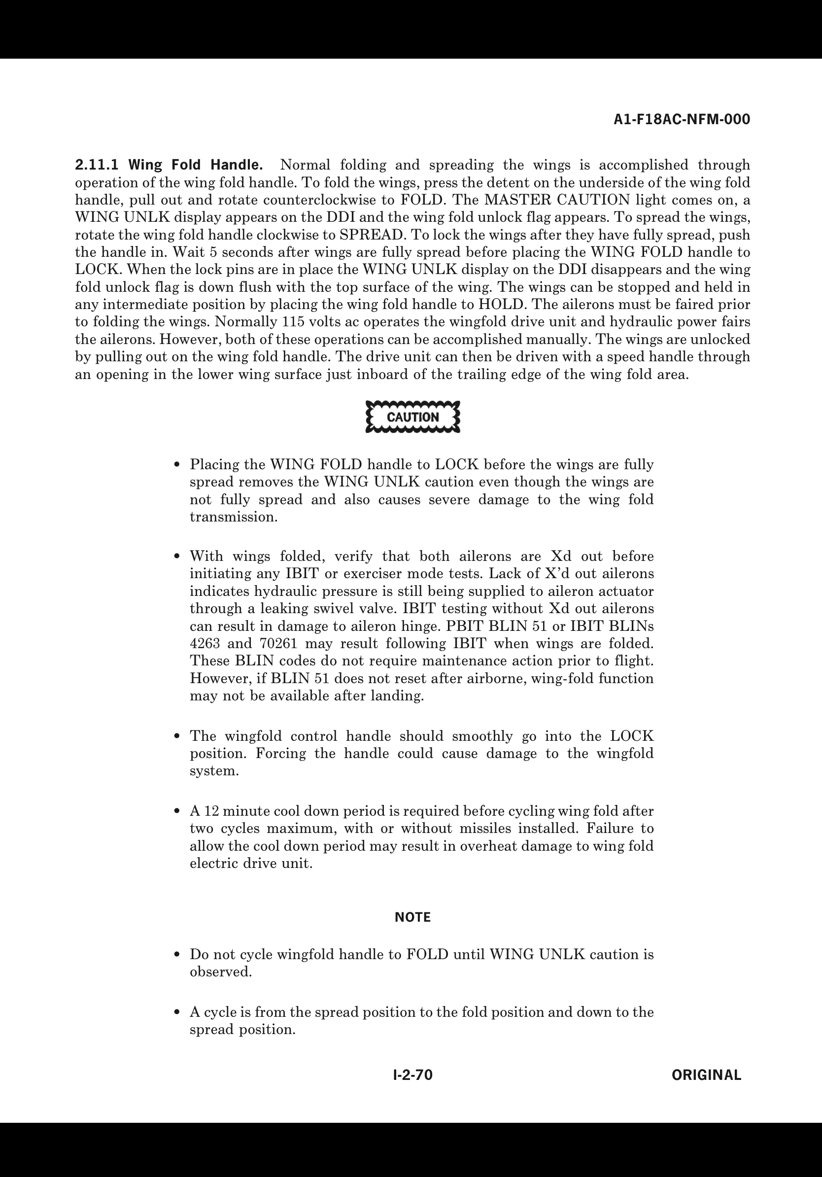
The simple answer is no, there is no push to ‘lock’ the wings in the folded position. For everything you could ever want to know about the wing fold handle here’s the relevant NATOPS manual page.

-
Will we ever get proper azimuth centering in RWS? As far as I’m aware, when using other than 140°azimuth, pressing the TDC on a blank area of the B-scope should center the scan on that location, similar to TWS. Currently this is not possible. This makes RWS a difficult mode to use when you have bandits > 30° off the nose. You either use a larger azimuth scan with it’s associated disadvantages, come nose on, or change to TWS. Non of these solutions are ideal, and scan centering in RWS would be the preferred solution.
-
Probably all depends on the tactical objective. If you’re actually going somewhere, I’d assume CSS will provide the most fuel efficient climb profile per nm traveled. Best rate of climb obviously gets you up as fast as possible, but probably does so at the expense of fuel burn/nm. Important if you need to get to alt fast for BVR engagement. 350 into constant Mach is actually what I tend to fly, just because it’s the simplest. My question is, should the FPAS climb speed profile adjust for the actual aircraft drag index? It would seem silly not to, otherwise why even include what is effectively an always incorrect figure?
-
We hear something soon, this issue is so frustrating when attempting to engage multiple bandits.