EvilBert VR
-
Posts
227 -
Joined
-
Last visited
Content Type
Profiles
Forums
Events
Everything posted by EvilBert VR
-

Gütersloh Airbase Project (Screenshots & resources)
EvilBert VR replied to Ghostrida9's topic in DCS: Cold War Germany
Chapeau! This really looks excellent! Cheers -
Phase 1, Wiesbaden Army airfield, radionav inaccuracies
EvilBert VR replied to Rongor's topic in Bugs and Problems
Just for carification: Wiesbaden has become an Army Air Field in 1998! Until 1998 it was Wiesbaden Air Base operated by the USAFE. Cheers -
PiMax Cyrstal VR OG; CWG Berlin area
EvilBert VR replied to 71st_Mastiff's topic in Bugs and Problems
Of course Berlin. That's what was causing the issues on your side. But as I said: Neither him or me or anyone else I know is facing the same things as you. I have no ideas with this atm. -
@winghunter Same name on discord?
-
PiMax Cyrstal VR OG; CWG Berlin area
EvilBert VR replied to 71st_Mastiff's topic in Bugs and Problems
Not a map issue! One of my buddies has a similar setup with a Crystal OG. Not facing any issues at all! What are your settings? -
West German Autobahnnotlandeplätze are being prepared: Landmarks and polygones are set:

-
Gütersloh Airbase Project (Screenshots & resources)
EvilBert VR replied to Ghostrida9's topic in DCS: Cold War Germany
Indeed.... Did not include the link. Here it is: >>CLICK<< -
Gütersloh Airbase Project (Screenshots & resources)
EvilBert VR replied to Ghostrida9's topic in DCS: Cold War Germany
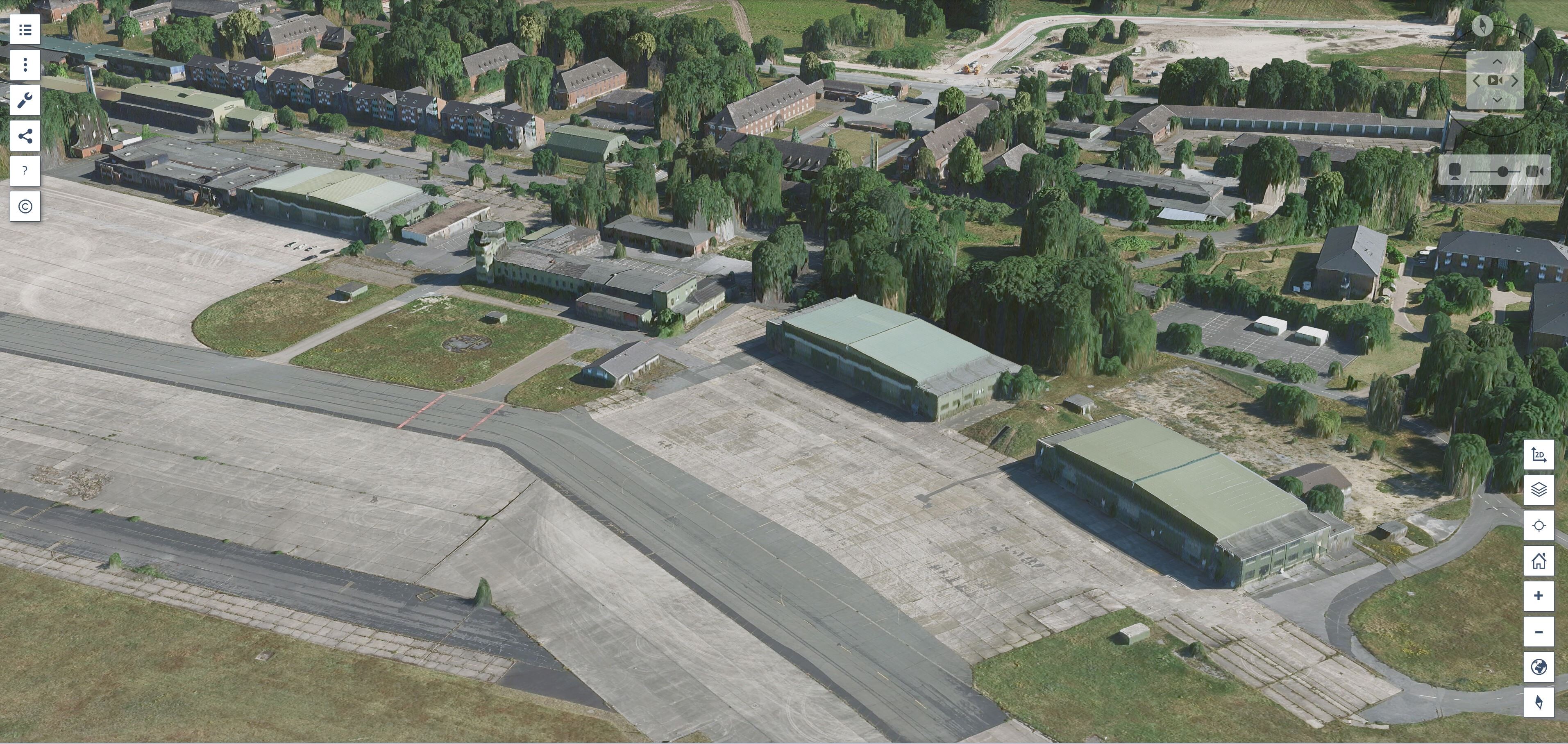
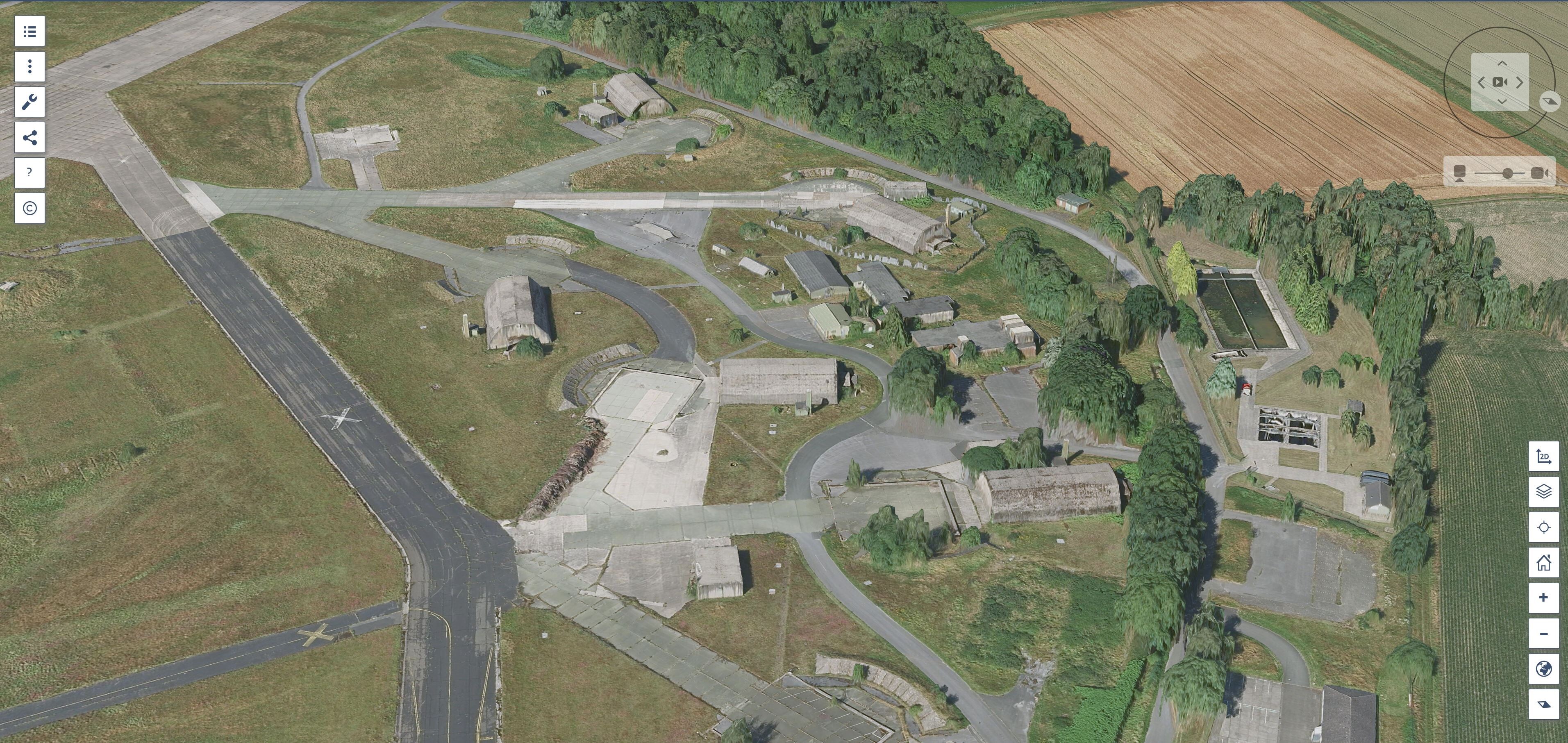
@Ghostrida9 Ambitious project! You need to use THIS website. The whole airfield in 3D! Cheers
-
@winghunter Tried the Web Editor. Somehow it won't accept the personal icons to be placed. Also: Is there a way to place static objects from the lib directly onto the map to get them imported in the .miz? Now THAT would be the most awesome feature! Another question: It adopts my polygones but will NOT adopt my landmarks?!? Cheers
-
Absolutely no issues here. Did you run a repair?
-
All installations done! Woof! What a work and research! Now hoping to get those thingies into UGRAs map!
-
Hey winghunter, thx for reaching out. I am allready in the stage of adjusting some of the landmarks in the map as well as coding scripts for removal of some of the misplaced items (especially lightpoles on airfields) to try and create a more realistic environment on some of the airfields. Cheers
-
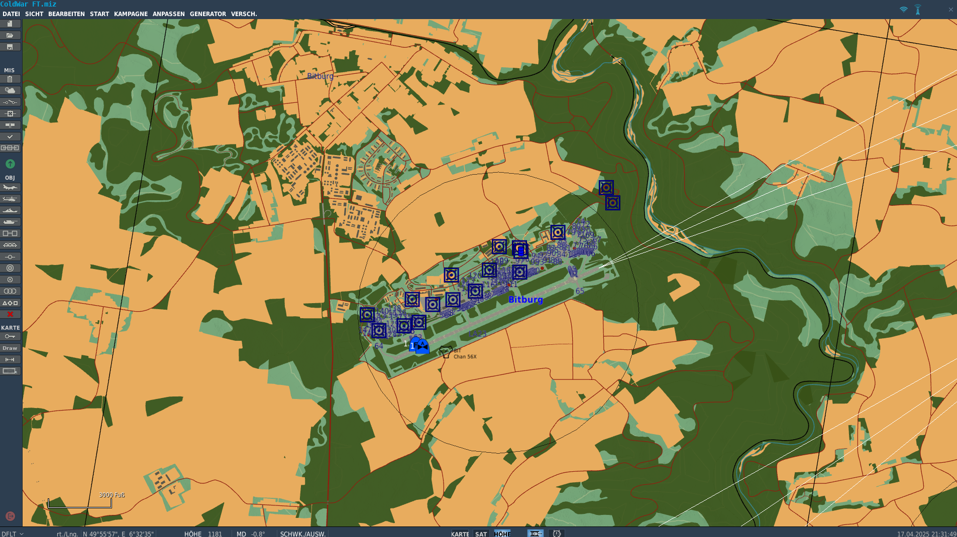
Just Ammo and Material Depots (NATO) And ADA Sites (NATO, coloured code refers to each nation)...
-
Everything (NATO-wise) has been set up and is waiting to be forwarded to UGRA. The categories are visible on the left side. Just as an example:
-
Absolutely! Despite the new ATC tower has not been present during the cold war era. It has been built way later.
-
Despite the driving lanes being only half the size as they should be (as been pointed out by another poster) I'd think the addition of the Highwaystrips would be a good thing.
-
Anything new on this topic?
-
While trafficing the Autobahn (A7) between Hammelburg and Fulda I noticed lightpoles along the sides. There should be NONE. Also disturbing ia a railway crossing and a traffic light junction along the Autobahn Maybe a future thing to delete or be aware of. Cheers
-
Maybe not...
-
502... Authorization failed!
-
Stefan, in the 80s EVERY German based played a vital and strategical role, not only the "unsinkable carrier" as to witch the northern guys refer to. To be more precise: Focusing on the Fulda Gap scenario (what the CW map is currently concentrating on) the northern airfields played a minor role than the ones on the southern part. Relax and wait what what later expansions will bring up regarding WP entering through the northern plains. Of course: as an ex Army Aviator (having served with Rgt20 and Rgt6), I'd wish to have both airfields present. But that's just the way it is. Be patient. Cheers
-
Found on YT while doing research is THAT awesome piece of ColdWar history that nearly depicts ALL what the upcoming map is about! Especially starting at 07:36 where birds start scrambling at Bitburg! Click HERE and enjoy!
-
Cant get DCS to run with the Meganex Superlight 8K
EvilBert VR replied to Winger's topic in Virtual Reality
Hey Winger, For clarification: Does your MeganeX work with other programms? Were you able to go through the complete setup? Then: There are known issues regarding the MeganeX and 5090 cards as well as with some SteamVR versions. Besides that the MeganeX WILL NOT WORK with other GPUs than NVIDIA! The latest NVIDIA drivers are required. As for SteamVR: Are you on BETA or on regular version? If so: which one are you using? When on BETA: Switch back to regular version, restart computer then switch back to BETA again and perform restart. For DCS: Choose SteamVR as the runtime for VR and you should be fine. Cheers -
It also works in the OH-58 Kiowa. In first person view.