Tholozor
-
Posts
3239 -
Joined
-
Last visited
Content Type
Profiles
Forums
Events
Everything posted by Tholozor
-

Were the first F16 blocks delivered with CCIP?
Tholozor replied to Gunfreak's topic in DCS: F-16C Viper
Oh, my mistake, I thought you were referring to the Common Configuration Implementation Program. -
need track replay JDAM issue with last update
Tholozor replied to KodiakVFA143's topic in Bugs and Problems
@shaji Something is definitely wrong in that video, as the JDAM shouldn't have access to the M904 nose fuze anymore. AFAIK, JDAMs in reality have never been assembled with mechanical fuzes in the nose, only plugs or the DSU-33 airburst sensor. The rearming menu should prevent incompatible fuzes from being selected. -
Were the first F16 blocks delivered with CCIP?
Tholozor replied to Gunfreak's topic in DCS: F-16C Viper
The CCIP upgrade happened in two phases, Phase I upgrades for Block 50/52 started being redelivered roughly circa 2002, with Phase II upgrades being redelivered roughly circa 2004. IIRC, Block 40/42 started redelivering roughly circa 2006 directly from Phase II. -
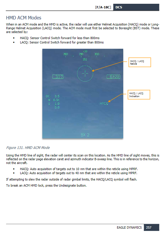
Page 257 of the Early Access Guide

-
New pilot model was introduced a few patches ago.
- 1 reply
-
- 2
-

-
Please post a track so we can take a look for ourselves, the video doesn't really have any tells what the problem could be. Regarding the TGP, press STBY in the top-left corner to select another mode (A-A or A-G).
-
JPF page will be under the MSN page for the selected weapon in the bottom-left corner.
-
Only one I could find in the User Files: https://www.digitalcombatsimulator.com/en/files/3318043/
-
work in progress Any word on a Data Transfer Cartridge?
Tholozor replied to Steel Jaw's topic in DCS: F/A-18C
Keep in mind that the data card functionality is something that is being developed as a core function not just for the Hornet. -
In the Mission Editor, in the aircraft's Additional Properties tab, you can change if the pilot is equipped with the JHMCS, HGU-68 ('Not installed' option) or NVGs (attached to the HGU-68). The JHMCS and NVGs can be equipped via the ground crew menu, but currently can't be removed back to the normal helmet.
-
wait for update Defaults fuzes require action in cockpit to work ?
Tholozor replied to Anubis_94's topic in Bugs and Problems
I apologize, my original description regarding the Mk-122 safety switch slightly off. When used in conjunction with the the FMU-139, the Mk-122 switch typically has two connections; an arming wire and a coaxial power cable. The arming wire is typically a few inches shorter than the coaxial cable, so it's pulled first, which closes a DC circuit inside the safety switch and permitting the capacitors inside to be charged to power the fuze (basically the weapon will not be charged until release is commanded). If EFUZ is set to OFF, no power will be applied and the weapon will dud. When used in conjunction with the FMU-152, the arming wire for the Mk-122 is not required (but, can still be used as a redundant safety), as the fuze is completely digital (with faceplate backup settings). When weapon release is commanded, the stores system sends a coded arming pulse that charges the capacitors, arms the fuze, and sets the arm/function delay. The stores system in the Hornet has specific codes used for each station set by the ordnance crews that tell the aircraft what weapon it has loaded and how the weapon was assembled so it knows what to do with it (this is done via the Weapons Insertion Panel on the armament computer inside door 14R). For a Mk-82, it depends on how the bomb was assembled. Assuming it's been assembled with an M904E4 fuze in the nose, and an M905 fuze in the tail, then: Setting MFUZ to NOSE, and EFUZ to OFF should result in detonation based on the M904E4 setting. Setting MFUZ to OFF, and EFUZ to INST should result in detonation based on the M905 setting. -
Question regarding AG weapons internal alignment
Tholozor replied to sirrah's topic in DCS: F-16C Viper
The imagers need to be cooled down as well (this goes for both Imaging Infrared and Charged-Coupled Device seekers). -
wait for update Defaults fuzes require action in cockpit to work ?
Tholozor replied to Anubis_94's topic in Bugs and Problems
For some additional context, the setting on the STORES page can control if the ZRF (zero retention force) solenoid inside the weapon pylon holds onto the arming wire for the bomb. You can see this in the Mk-82 video, it still has the arming wire on the bomb because it was set to OFF. On the GBU it's a little different depending on how the weapon is put together. An arming wire always goes to the front, which enables the thermal battery for the guidance control unit, and a second wire goes into the aft section to release the fins (these two wires should be visible on the weapon prior to release on the DCS model). If the weapon has the FMU-139 or FMU-152 installed, an additional arming wire is not required with the Mk-122 electrical safety switch. Setting EFUZ to OFF acts as a "safe" option as no electrical current is applied to the switch to charge the capacitors, and the weapon will dud. EDIT: Correction regarding the Mk-122 safety switch is explained below. -
Depends on the angle:
-
@mike.roper 1. It's listed as 'RAID/FLIR FOV Select Button.' 2. 'Dispense Switch - Aft' will perform the following: If the DISPENSER switch on the center panel behind the stick is set to BYPASS, then Dispense Switch - Aft will dispense flares. If the DISPENSER switch on the center panel behind the stick is set to ON, then Dispense Switch - Aft will initiate the selected Manual Program (set from the EW page). 3. Not sure exactly which switch you're referring to here. Are you talking about on the actual Hornet throttle or the TM Warthog throttle?
-
One thing that would help resolve this is Bump Acquisition (not implemented currently), where if the radar goes STT on a contact, you can reject it and exclude it from being locked for a few seconds while attempting to acquire a different target.
-
The ATFLIR and LITENING don't have boresight modes on the Hornet, but instead can slave their line-of-sight to the velocity vector. You can either double-press the NWS/Undesignate button on the stick, or press the VVLSV option on the FLIR page.
-
This is normal. The pilot model moves based in relation to your in-cockpit viewpoint position. When in an external view, your in-cockpit view commands are frozen. If someone else were to be observing you (or you observing them) while moving about inside the cockpit, it would appear normal.
-
Without a device with laser spot tracking capability (targeting pod, Laser Maverick, or LST pod which we don't have in DCS), you will not have any indication of the location of the location of the laser, and must rely on precise coordinates for targeting, or JTAC talk-on (LGBs do not provide laser spot capability to the aircraft, and are only active once released from the aircraft). LGBs will guide on their own once they leave the aircraft provided a) there is a laser designating within the seeker's field-of-view, and b) the laser code matches the code the bomb was set for on the ground. Watching your track, it's user error. The JTAC is using Type 2 control, so you need to be 'Cleared Hot' before weapons release. In this specific case, since you don't have any dedicated LST capability, you'll have to call 'Spot' anyway once you visually spot the targets. After 'Spot,' call 'In,' and the JTAC should clear you hot. Chuck's Guide is incorrect regarding the operation of the LST/NFLR switch. This switch was only used to power on older accessory pods on the right cheek hardpoint (either the AN/ASQ-173 Laser Spot Tracking pod or the AN/AAR-50 Thermal Imaging Navigation Set pod). Both the LITENING and ATFLIR pods have dedicated LST functions that are built into the pods themselves, and do not require the use of the LST/NFLR switch on the sensor power panel.
-
A track replay would help diagnose the issue. The LST switch on the Hornet is an old switch that was used for the AN/ASQ-173 Laser Spot Tracking / Strike Camera pod that used to be able to be mounted on the right cheek station, and has no function in the version simulated in DCS.
-
Not necessarily the cursor itself, but at the location of a TGT designation. If a TGT does not exist, the markpoint will be created at the aircraft's position. So yes, if you use the radar to create a TGT, you can markpoint it.
-
Already known (4921 feet roughly equates to 1500 meters, so probably just a conversion display error):
-
F-14 A/B feature follow-up, wish list and beyond
Tholozor replied to scommander2's topic in DCS: F-14A & B
Also this for the to-do list: -
green scratches in the Apache cockpit - are these missing textures?
Tholozor replied to Zyll's topic in DCS: AH-64D
Probably paint primer. Since a good chunk of aircraft parts are made of aluminum, the best primer for it is zinc chromate, which is greenish-yellow in color. -
When a steerpoint in the F-16 is moved, it applies a relative slew delta (change) to the entire steerpoint database. For example, if steerpoint 1 is slewed 50 feet to the north, then every single steerpoint is also slewed by the same amount in the same direction.