
stormrider
-
Posts
876 -
Joined
-
Last visited
Content Type
Profiles
Forums
Events
Everything posted by stormrider
-
You already have a 3090 and a 1090k with good 64GB Ram, why would you want to build a fresh new system?
-

Next Gen VR headset is here! Varjo Aero.
stormrider replied to Thinder's topic in PC Hardware and Related Software
-
I'm buying both. Given how toxic this forum is, I don't really blame them.
- 87 replies
-
- 14
-

-

-
Due to the lack of options, Im considering a Diy using a leobodnar board for example. Im definitely not spending 2k on hotas.
-
What are you talking about? It's a game!
-
Thats what I call boring...
-
Couldn't agree more.
-
Couldn't agree more. It's shame they changed its name from the original "Strait of Hormuz map", because for a Persian Gulf map, it was left lacking.
-
Please, no politics here.
-
HP Reverb G2 not working in DCS
stormrider replied to drbaker's topic in PC Hardware and Related Software
Ok this means that even if your installation is outside of steam, dcs / G2 can still pipe steamvr api. That's nice. -
HP Reverb G2 not working in DCS
stormrider replied to drbaker's topic in PC Hardware and Related Software
Out of curiosity, what if your installation and all your modules were not purchased through steam, but from ED store, are you unable to use the G2? -
That's a counter insurgency campaign. Billion dollars machines against guerrilla armed with infantry weapons. Not to put you down or anything, anybody can wish whatever they wish, but for me, that's very uninteresting. On the other hand, conventional wars like Desert Storm, or perhaps even fictionalized conflicts like a what if boots on the ground intervention in Kosovo, using the Georgia map, or a modern what if Yom Kippur war, that'd be great.
-
Xmas
-
DirectX is Microsoft, not nvidia.
-
Vulkan is brand agnostic.
-
That is the sound of inevitability, Mr. Anderson..
-
Same issue here. Best solution for me is to render it both eyes.
-
Oh my, I feel very sorry for you. With all the best gear that money can't buy and it doesn't work, must be very frustrating. Hope that next jewel priced gadget, the varjo will bring you better luck. Cheers
-
The problem that I can see here is that you want a simple solution for a complex problem. Identification in war has all being a difficult business, even for the trained human operator, with or without a bms. If you want easy and simple, then you're willing to accept a cheating AI. If not, then complication is inevitable. Complication means coding ambiguity. Several so called simulators out there tried and failed.
-
What he's trying to say is that the gazelle's physics are dubious.
-
It was probably a conflict of interests. They had the product in development while ED, which has the priority, had the Apache. Ed gave them a window of release and they failed to get the product up to a releasable level. Now, they were pushed over to a next available release window which I bet they were more than happy to take. In the end it's a win win for everybody. To be honest, I wasn't very excited for the Kiowa myself. There are several missing core features in the DCS, that in my opinion make helos gameplay less than optimal. With the announcement of the Apache, everything has changed and it seems all now too promising and exciting; at least for the mid/long term and I'd be more than happy to play both modules.
-
Honestly, I don't care.
-
I dont really think that a global map has anything to do with whole world transiting. If you want, yeah, go for it, get a *few tankers and go fly for a day, in VR. On the other hand, the possibility to choose anywhere to fly is unmatched, and as a business, you can sell specific assets for different uses.
-
What joystick is that? That'd be a perfect match for a game like Steel Beasts!
-
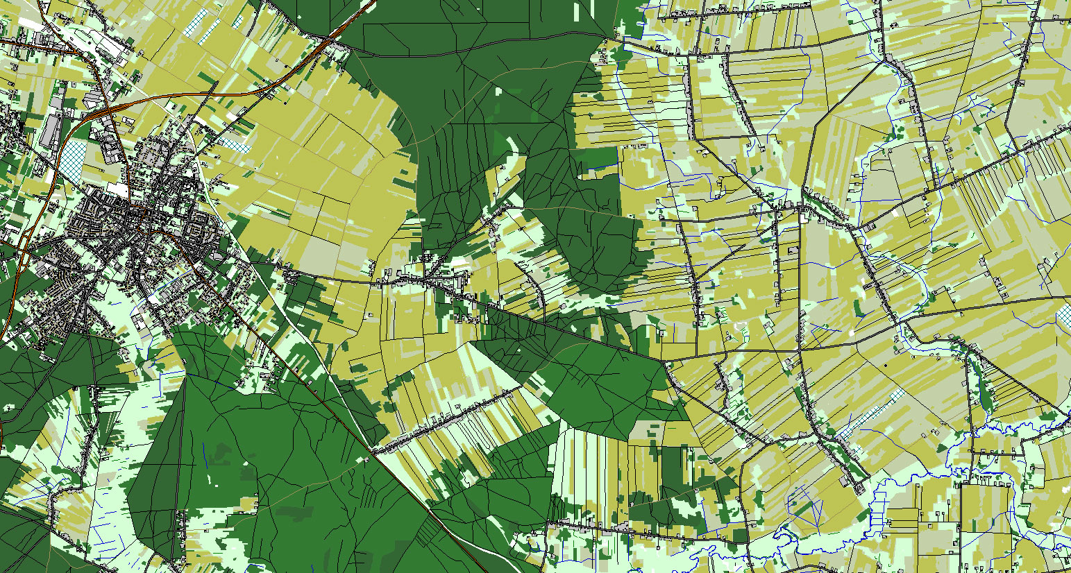
Please, don't pretend you know anything. There's nothing stupid about it. If done correctly, they could have most the data in the cloud, and have all the objects recognition from GIS data, like Flight Simulator, done with AI algorithms to correlate with a local objects database. For the base GIS data, ED will probably strike a deal of one of the big suppliers, who already have this all right. Just to give an example, I recently worked on a project to make a map for Steel Beasts Pro PE and I decided to go with a map that is relevant to our times while still providing the best options in terms of data availability. I chose to create a map of a region close to Suwalki gap, in Poland, in a likely corridor from there towards the capital. The data was amazing. > 1-2m/px resolution for the heightmap > Superb vector data with everything, every object and all this data sorted and categorized. Even the type of trees and their percentages withing a given wooded area was provided in the metadata. All building were classified into hundreds of types, like residential one, two, three floors, schools, hospitals, industry, garage, shops.....roads according to their ground types and lanes... > To go beyond that, I also used AI recognition algorithms in order to classify the surface types according to their spectral signatures, so I could differentiate, for example, green grass, from wheat; swamps from dry land and so on.. The picture below is made only of vector data of a small area sample of this project: What simulations engine provide nowadays is a synergy between all this data in a way that it is available only when needed. The engine itself will build the map according the a metadata and pick the right object that fits in. One can create templates and biomes to populate a given area and that will only make it even better.