
BarTzi
-
Posts
967 -
Joined
-
Last visited
Content Type
Profiles
Forums
Events
Everything posted by BarTzi
-
Orot Rabin is a power station, lcoated roughly 6km north west of Hadera, which is the last Israeli city to be included in the map. It is also the biggest power station in Israel. The structure itself is easily identified by the four tall chinmies and the very long pier. The pier is used for unloading coal from cargo ships, and transporting it into the station compound. The station area is already in DCS, although it is missing the pier and the chimnies. Why am I bothering you with it? The three most important Israeli assets on this side of the map are: Ramat David Haifa oil refinery and port area Orot Rabin power station Having those accurately modelled in the sim provides opportunities for both the blue (defend those sites) or the red (attack those sites) sides.
-
But they weren't included on release, which makes this a legitimate thread.
-
Ramat David should have all the equipment modern millitary airfields use, including ILS and Tacan.
-
You got upwind and downwind wrong. Oh and yes, its' because you need more practice. Common mistake for new people is to try and land on the carrier immediately. This will never go well. Learn to fly the pattern, learn to land on an airfield and land to fly ON SPEED before you start practicing case I recoveries.
-
Approach turn bank angle - trouble keeping constant
BarTzi replied to markturner1960's topic in DCS: F/A-18C
Bang on? You have control over the aircraft. If the bank angle is not what you want, move the stick accordingly. If the rate of descent is not matching the numbers you want - use the throttle. React and adapt to the conditions and circumstances. -
Let's break it down: 1. "The map is far from completion". How would you know? Are you a closed beta tester? It looks very close to being complete. 2. "Not mentioning the lack of Cyprus". Cyprus was originally not planned, but was recently confirmed as a future addition. 3. "Catastrophic sales of the Channel map". How would you, or I, or anyone know? We don't have access to that information. 4. "Weak sake because of the absence of Cyprus?" Respectfully, Cyprus has only one base that is relevant to this map. The bigger problem we had originally is that the map didn't allow to place the carriers far enough from shore, which limited the scope of carrier ops in that map. So no, Cyprus isn't that much of an attraction to cause the map to sell less.
-
It's a massive compound. Here's a good view of it when the airplane turns around for final: Those chimneys can really light up the sky.
-
The airport was there four years before they started building the refinery. Although both were expanded with time, the British mandate is credited for the original construction of the refinery and the airport. They are listed in the airport charts as obstacles.
-
Switch to A/G mode.
-
Approach turn bank angle - trouble keeping constant
BarTzi replied to markturner1960's topic in DCS: F/A-18C
If you are not letting go of the stick, what stops you from correcting it back to where you want it to be? -
Dear Ugra, While watching this video I was seriously impressed by the level of details, unique buildings and overall attention to details of Haifa and the surrounding area. However, I could not help but notice one of the major landmarks of the city was missing. I'm talking about the refinery cooling towers. Compare your approach to the runway: to this one of a 172: or this one: to get a sense of their size. They are 270 feet tall. This is probably the easiest way to recognize the Haifa refinery compound (which is one of the most strategic positions on this map), and it can't be missed while approaching the airport. It is also widely recognizable by anyone who lived or grew up in the city - you can say it's one of the symbols of the city. The refinery even used to light the area during the night: https://media.sciencephoto.com/c0/03/71/67/c0037167-800px-wm.jpg Also - as a side note, the top part of one of them recently collapsed: https://www.ynet.co.il/PicServer5/2020/06/12/10030562/100305610992499640360no.jpg I think it will be really nice of you guys to consider adding it in the future.
-
Will EXP3 mode of air to ground radar be optimized and improved?
BarTzi replied to kaoqumba's topic in DCS: F/A-18C
Looks comparable to me ... -
SAR High Res imaging Quality on the An/APg73 Phase 2 Radar
BarTzi replied to Kev2go's topic in DCS: F/A-18C
You would be bothered by weather in DCS only if it's not a pre planned strike. If you are expecting to scan an area, find targets with the radar and then engage - they better be big and distinguishable (runway, bridge, sam site), otherwise you just won't be able to tell what you are looking at. -
Has over? Isn't DBS like EXP1/2?
-
44,000 lbs and below - you can do whatever (no burner, burner midway through, full burner takeoff). Above that - you should use the burner.
-
Hi MAESTR0, to fully appreciate the work you guys have done here, will you consider releasing an overlay of the map showing the locations of the bases and unique buildings (turists attractions and so on) that were added to this map?
-
One minor detail - when set to field and you deploy your hook, the switch will automatically transition to carrier.
-
I think you will have to mod the plane somehow to make it happen (there's a CFT mod out there already so it might be possible). However, I'm not sure if it will break IC or not. Making 3d models isn't something I know too much about. @Miro Vv1.2 is the updated version, and it also includes the additional liveries you requested. Enjoy!
-
There's no logic here. That's just how it was made.
-
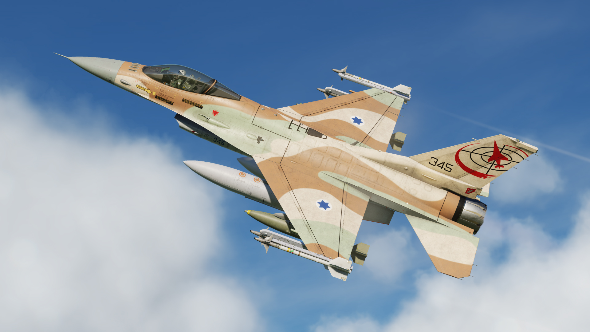
Hi Wolfox1, I wasn't questioning your expertise (even though you just came out on nowhere) and I appreciate the feedback - but I don't think calling the livery I made a wasted job is a respectful way of criticizing it. 1. Ramat David is a 20min drive from my place at the moment. I've done the reaserch - and I know what the planes look like. I wanted it to be bright since that's what happens when they are parked outside for years. Your suggestion brings it closer to the actual FS colors which is not something I personally like. 2. Time of day: lighting is done by DCS. The livery matches real world pictures that I have over here. 3. The nose cone is supposed to be bright, it's a newer block that the IAF never owned. I wanted it to look like the F16I. It's not a replication of the Barak, and it's not going to be. It's not the same plane and some elements had to be borrowed. No matter how you look at it, it's a fictional livery. I toned down the sun exposure effect and released v1.1 with a slightly darker nose cone (my friends over here will share their opinions on it). If you have something to say, do it in a respectful way via private messeges. This is not what this thread is for - don't come here to pick apart my work and then brag about it.
-
Hi Wolfox1, I don't quite understand the context of color-full here, do you mean its too bright? Those are the FS standard colors used by the IAF. It was compared many times with real life pictures of the jets, and I think the differences are mainly due to the way DCS does lighting, and they are subtle. It's important to note that when the planes are parked outside and are used - this is exactly what happens to their paint. It becomes brighter and it deviates from the exact FS shade (especially the brown and the sand), which is what I was going for here. However, I would happily look at your work (if you are willing to send it over) and compare it to mine. I will change if it it's more accurate overall.
-
The default mode is T up. Using mode-> DCTR after you've decentered the map, will not un-do it. You should simply go back to T up (mode -> T up)
-
N up, T up and DCTR have always been there. The default is always T up, as it should be. AFAIK this map is pre loaded (so think of it like a texture of a map loaded into the jet before/ during ops or deployments). When you hold an actual map and then rotate it, the text doesn't rotate in the opposite direction to keep it easy to read - so that's how it should be.
-
Absolutely. The version you are requesting already exists. I just didn't pack it with the rest of them because I thought it's too much.
