
Rongor
-
Posts
1595 -
Joined
-
Last visited
-
Days Won
3
Content Type
Profiles
Forums
Events
Everything posted by Rongor
-
YES! YES! YES! ED we love you! from
-
sad to not see this fixed after being reported so long ago...
-

Lochini PAPI lights are not aligned to 3° glide slope.
Rongor replied to AJaromir's topic in Bugs and Problems
I can confirm Batumi has the same issue, which is causing trouble in the A-10C Basic Flight Training Qualification Campaign when you are ordered to follow the PAPI and then get a penalty for flying above the gildeslope and on top have to do a significant flare edging stall speed to not slam into the runway...
-
Coming up with the idea of porting everything from the Iraq South map from Basrah down to Doha over into the Persian Gulf map seems like common sense. Why would ED disregard this opportunity?
-
I always learn the most detailed startup procedure with each new module. If its simulated, I'll include it in my cold start flow and will create a lengthy checklist featuring every step. Whatever knob I touch, I then learn all the underlying devices on the side while getting used to this startup flow. This procedure helps immensely with learning and understanding the aircraft. I see that many people are too impatient or simply not interested in learning these things and only focus on how to get into launching weapons as fast and with the least amount of switches to press as possible. Only these comrades are usually those who then don't have any clue what to do if something's not working or any damage demands system knowledge to solve an issue. When I know my detailed startup flow by heart, I usually create an abbreviated checklist. From then on I'll do the lengthy checklist with each first flight of the day on that specific module and the abbreviated checklist with any flight in thus module afterwards for the rest of the day. This assists me in keeping me proficient with the entire range of onboard systems, while cutting down the checks for all but the first flight.
-
Its a problem with the currently basic state of the EGI implementation. Clicking EGI1 on and off will update the map but it will still remain stuck at the updated location then. Couldn't figure out yet what exactly triggers this.
-
unable to reproduce the left wheel does not fulfill its function when we taxi
Rongor replied to samu's topic in Bugs and Problems
While it takes some practicing, there are some things to pay attention to: 1. turn the AFCS knob to off for taxi operation 2. apply some thrust, only enough to set her into slow roll 3. Only after she starts rolling commence steering. Do not steer before she is rolling 4. Don't turn the steer knob into max. Try to make it work with small inputs. The faster you go, the more you will experience what you described when turning the steering knob beyond say 10 and all the way up to 30. She will bve unresponsive to such high inputs whenever you are beyond walking speed. 5. decrease thrust back to zero most of the time while taxiing, only apply thrust whenever she needs a little acceleration to maintain taxi speed. -
I am facing this exact issue right now as well. Seeing this report being not even acknowledged by PC after well over a year is quite sad. Doesn't generate the trust I require to invest in a 70 USD Kiowa by PC anytime soon.
-
need track replay Other players' cargo door in MP has issues
Rongor posted a topic in Bugs and Problems
-
Only way to change the ADF freq currently is to edit the 1st ADF preset and enter it in MHz, so for 350 kHz enter 0.350. Then return and reload the 1st preset. Though it doesn't really matter since there is no ADF bearing readout for now.
-
reported earlier Missile warning voice, right and left warning mixed up
Rongor replied to Snuten's topic in Bugs and Problems
- 1 reply
-
- 1
-

-
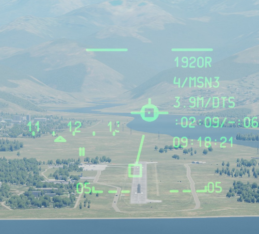
In this track you seem me activate Bob. The moment I acknowledge cautions and switch the center MFD to the map, Bob is already in control. Then I do a series of climbs and descents. Whenever the vertical speed increases, the altimeter rapidly adds to the altitude. The moment the vertical speed is set, there is a noticeable pause in altitude increase indication, then it continues at a slower speed. When returning to level flight by reducing the vertical speed to zero, the altitude indication decreases for a bit, although there hasn't been any descent. Same for the opposite. Introducing descent instantly decreases the altitude at a higher speed than it continues to decrease when the maximum negative vertical speed has been achieved. When reducing the descent, the altimeter actually increases for a bit. It's very subtle at times but it should be easy to observe. Its more noticable at higher air speeds. This track was made below 100 kts, maybe I should've gone faster. vertical speed adds to alt.trk
-
Can we have a key binding for all fuel pump ON/OFF?
Rongor replied to daniellegraham's topic in Wish List
To follow the correct startup procedure you would still need to flip only a few of them at a time, so mouseclicks seem to be the most convenient solution. -
You don't need a key for the detent when disabling the gate switch. You only need to move your control lever beyond the specific angle representing the ECL detent ingame.
-
Can you elaborate this comment a bit? I watched it and can't see anything I wouldn't expect from any helo settling down. What exactly is a hint on a bad FM in the last 17 seconds?
-
I think its just the current state of the flight model combined with mostly non-functional AFCS
-
Ramp start is cold start. Bypass is needed to disable automatic dispense. If it's not on bypass, it will dispense automatically when your CMWS is detecting a launch. Manual dispense should be possible regardless the switch.
-
Decouple gunner from head movement
Rongor replied to AlpineGTA's topic in Controller Questions and Bugs
I am using TrackIr and face the problem that I have to pause the headtracking to use the mouse for aiming/steering the gun. Using the special setting option is no solution because then the mouse doesn't affect the gun anymore and there's no way to bind it in controls setting as the mouse inputs are greyed out there. -
Good to know, thank you!
-
Didn't watch the track but tried it myself on the side a bit today. I'm not sure there's an issue. The whole maneuver is depending on touchdown speed. I think I touched down with around 60 kts and while lacking the practice (and the DAFCS) to make it look acceptable, I could roll out on aft wheels for some seconds. We don't really know the supposed speeds for this to achieve and we lack the weight on the wheels affecting the DAFCS.
-
This is best noticeable while using Bob (most stable way to fly straight and level currently) but also happens in absence of Bob. When in level flight and starting a climb or descend, the indicated altitude instantly adds some tens to hundreds of feet. This offset then gets subtracted again when vertical speed is decreased back to zero. Same for descends, the moment you return to level flight, some tens to hundreds of feet instantly get added to the altitude indication. It behaves like the current vertical speed is in a way added to the actual altitude indication, therefore showing higher altitude during climb and too low altitude while descending. Will add a trackfile tomorrow
- 1 reply
-
- 1
-
-
missing track file Hooked Cargo can not be released in multicrew
Rongor replied to Ben149's topic in Bugs and Problems
I did sling load a lot the recent days and had this issue only occasionally on MP but singlecrew. The rope wouldn't come off as long as I didn't manage to eventually tear it. MFD WCA page confirms the middle hook open though the rope remained attached. As usual this happened during several hours long MP sessions so I won't provide a trackfile -
It does work on my Virpil SharKa panel on a 3way switch, all three positions can be selected just fine, including the ARM position.
-
w.i.p ICU blinking , EAPS warning, few questions.
Rongor replied to grim_reaper68's topic in DCS: CH-47F
ACK only applies to the messages in the WCA, the blinking ICU is a different item (to be ignored while w.i.p.) EAPS can be acknowledged so they wont trigger master caution anymore. EGIs can be enabled in the power format page in your MFD. So none of these should bother anymore. -
Assuming that the center of gravity will be in front of the aft landing gear, it will naturally induce a nose down momentum when hitting the ground if you don't grease the touchdown, so I would assume the pilot might need to be ready to pull the stick back at least some milimeters for a moment. Keep in mind that the AFCS isn't really fleshed out yet, so any support for ground handling is still missing. From the TM: