razo+r
-
Posts
12979 -
Joined
-
Last visited
-
Days Won
2
Content Type
Profiles
Forums
Events
Everything posted by razo+r
-
Do you guys feel it really hard to rotate when taking off?
razo+r replied to Raedyz's topic in DCS: F-16C Viper
No -
Community A-4E-C v2.3 (May 2025)
razo+r replied to plusnine's topic in Flyable/Drivable Mods for DCS World
You have the historical filter turned off. It's the clock icon at the bottom in the editor. To select the warhead, click on the orange triangle in the top left corner of the weapon in the weapons selection menu. -
Sometimes it can happen there is something bound to it by accident for whatever reason. You should confirm that this is not the case. Both with axis and regular keys. Otherwise, does it happen in other aircraft too? If it does, it might be also a control issue or a hardware issue.
-
Have you checked your axis controls for any unwanted bindings?
-
Also make sure your anti Virus hasn't removed any necessary files. If it did, add that file as an exception and restore the file.
-
Turn off the historical filter, it is the clock/watch icon at the bottom bar. Mods are not compatible with that filter.
-
Can you perhaps upload a short track so we can see how you are doing it?
-
If you enable the control indicator (RCtrl+Enter), can you confirm you only apply aileron input and no elevator input?
-
DCS World Folder/File Structure - Missing Aircraft
razo+r replied to Igor4U's topic in Installation Problems
Mainly new cockpit and exterior 3D model and some bugfixes. That's been it. -
DCS World Folder/File Structure - Missing Aircraft
razo+r replied to Igor4U's topic in Installation Problems
It doesn't add any "remastered" to the Tag. It stays "F-5E" regardless if you have it installed or not. It will also not remove any folders. You will have both installed at the same time, but it will use the remastered one regardless. You will automatically use the remastered F-5E if you have it installed. If you have the old F-5E and the remastered installed, it will use the remastered one, but it will not add any tag like "2024" or similar. -
DCS World Folder/File Structure - Missing Aircraft
razo+r replied to Igor4U's topic in Installation Problems
In all my years I had a lot of skins installed in the Coremods directory and never have I had any issue. Just my two cents. -
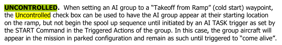
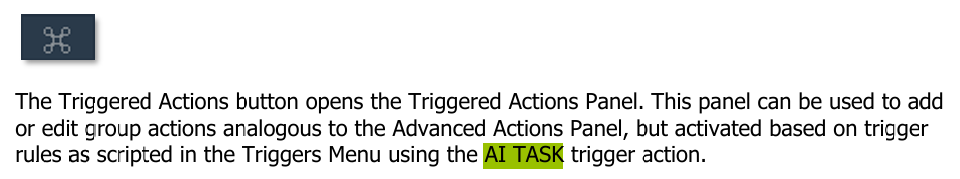
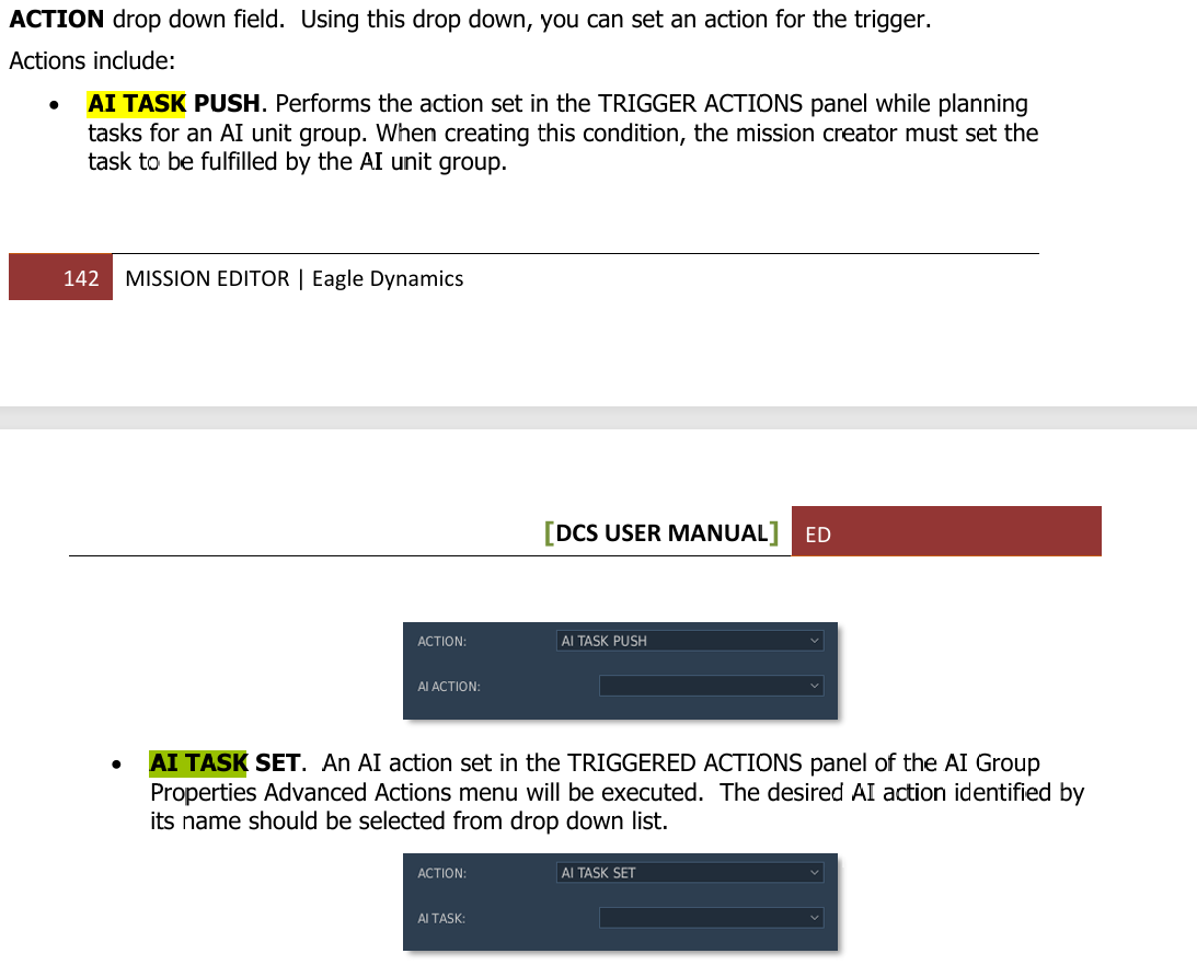
Use the "uncontrolled" tickbox paired together with "push Task". And in the trigger list: If you set it up that way, you can have an aircraft group visible on the ramp without them starting up.

-
F-16 training lesson - ground units in piggy back mode?
razo+r replied to TheBiggerBass's topic in Bugs and Problems
Just checked the mission, seems it's a mission specific issue. -
F-16 training lesson - ground units in piggy back mode?
razo+r replied to TheBiggerBass's topic in Bugs and Problems
Which training lesson? Do you have any mods installed? If yes, have you already tried to uninstall all of them and running a repair? -
DCS World Folder/File Structure - Missing Aircraft
razo+r replied to Igor4U's topic in Installation Problems
Old Modules like the Su-25T and FC3 aircraft had most of their files in the Bazar directory, before the "CoreMods" folder was even a thing. That's why some modules may missing in the "CoreMods" folder. Well, you need to check the ingame Module Manager. If it has the F-5E upgrade enabled, you will be using the upgraded F-5E. The upgrade basically overrides the old F-5E. If you have the upgrade enabled, you cannot fly the old F-5E unless you manually disable the upgrade. There are two ways you can install liveries. One is in the saved games directory (which I don't know the correct pathing) and the other one is in the CoreMods/Aircraft/your_aircraft/liveries (or Bazar/liveries for older models). Just note though that some skins may be only available to certain countries. You can check the entry.lua of a skin to find out if that is the case. You can either delete the country definition in the entry.lua or just select the appropriate country in the Mission Editor. -
F-15C can't hold orbit above 30'000
razo+r replied to NoJoy's topic in Aircraft AI Bugs (Non-Combined Arms)
I am not sure. I set it to 440kts in the orbit task and then it worked. 70% but still with 3 fuel tanks? -
F-15C can't hold orbit above 30'000
razo+r replied to NoJoy's topic in Aircraft AI Bugs (Non-Combined Arms)
Increase the speed. The orbit is set to 260kts (I guess ground speed) which is about 150kts Indicated, wayyy too slow. Also note that when you increase it's speed, it will be able to hold the altitude but because of the steep bank it's doing and basically fully loaded, it will use it's afterburner to maintain altitude. Consider lightening it's load. -
Make sure the historical filter (the clock symbol) at the bottom in the editor is turned off.
-
Those two pictures you mention are triggered via the Triggers.
-
From the Manual. "Create Mission Briefing"
-
[Known issue] f14 not authorized DLC will be disabled
razo+r replied to dave76's topic in Bugs and Problems
Yes, Norton is most likely putting the file needed to run the Module into quarantine. You can either restore the file directly via Norton or add that specific file as an exception to Norton and run a DCS Repair. That should fix the issue. -
They'll likely get downloaded again with each update and repair, and in multiplayer obviously if others have a skin selected that you don't have you'll normally just not see it or in the worst case will see the "missing texture" texture. IC compliance not guaranteed. So that would be another thing you have to watch out for. Might or might not trigger the IC, preventing you from joining servers with IC turned on.
-
Try removing your mods and see if it solved it.
-
That option is only available to non-AI units like Clients and Player. So make sure you have no AI wingman either.
-
That picture does not show anything about the original issue from the first post... No description doesn't help either. It's also not a track...