xvii-Dietrich
-
Posts
796 -
Joined
-
Last visited
-
Days Won
2
Content Type
Profiles
Forums
Events
Everything posted by xvii-Dietrich
-
Agree 100% Fenrir. Apart from them being good targets (esp. for the upcoming DH98 Mosquito), it would allow a level of intelligence for the Kammhuber Line / Himmelbett Zones. Integrating WW2 radar with Combined Arms would allow a "ground-control / TOPHAT" role. In addition to the references that Fenrir gives, I can highly recommend this one: https://www.geschichtsspuren.de/ It is in German, but it describes the sites and the radars used. The Datenbank menu allows one to search for specific types and you can plot maps showing the locations (and then click on the icons for exact details). For example: https://www.geschichtsspuren.de/index.php?typ=1&quad=8&sort=0&option=com_fmdb&task=1&Itemid=63 We used this for planning radio sites for the Storm of War (SoW) campaign. SoW are currently planning new material, and it would be great if we could incorporate radar units into the new campaign.
-

Suggestion/ Bug - reduce contrail density
xvii-Dietrich replied to philstyle's topic in General Bugs
An internet image search for "B-17 contrails" returns numerous photographs. These show different densities for B-17 contrails, varying from quite disperse to some as thick as those currently (07-Aug-2018-Beta) rendered in DCS. However, I agree with the original post that it would be of great benefit to turn down the density. My reasoning for this, is to make the trailing edge of the contrail (the point way behind the aircraft where it no longer renders) less distinct. Presently, the contrail is very thick for several kilometres and then it stops abruptly. Making the contrail less diffuse would definitely help with this. -
I too would love to see the P-47D as soon as possible, although I know that it has been delayed due to technical challenges and unforeseen issues. However, I noted that this was posted on 02-Aug-2018. Excellent! :D Of course "soon" is a bit vague, but we know that there has been a completely new simulation built for radial engines. The Yak52 is the first to get this and that has just been released (with very positive community feedback). I would hope that this new radial engine sim will find its way into the P-47D. We just have to wait and see. ;)
-
Really nice photo. It would be great to see the number of paint schemes expanded... especially with ones like this.
-
Perfect. Found them. Many thanks!!! :thumbup:
-
On some of the pages for the WW2 assets pack (For example the Steam WW2 Assets Store page: WEBPAGE / SPECIFIC IMAGE ) there are obstacles. Things like barbed wire, tank obstructions, etc. I've been searching for them in the mission editor, but simply can't find. Could someone please tell me where to look? (Country, Unit type, Category, Name, etc.). Thanks!
-
I agree with this. There are a few anomalies, but the eponymous region of Normandy itself is covered pretty well. The map looks stunning and I get good frame rates out of it, even on my old laptop (albeit with a few settings turned down a notch). That said, I would still welcome any improvements (esp. additional populating of the non-Normandy parts and correcting erroneous airfields). A lot of the concerns about the map could actually be remedied using assets, aircraft and alterations to the core DCS simulator. The biggest improvement to multiplayer and online campaigns would be the addition of a "mission-editor-placeable" fighter strip. This would give the best flexibility and allow emulation of the types of makeshift facilities used by the Luftwaffe during that time. And German ATC for Evreux, please. Some more appropriate call-signs would also really help in this regard. There was a major Freya site at Creil. Part of the Kammhuber Line. :-) Freya and Würzburg sites would also make excellent targets for existing aircraft as well as the future Mosquito. Really looking forward to the Ju 88 A-4! These were in use by I./KG54 during this time period, based out of Evreux, St.Andre and Juvincourt. They suffered huge losses during that time, but it will be really good to see them in the game (even better as flyable *hint hint*) Not sure about the He 111 though. Did you mean He 177? Not a lot of air-to-U-boat contact in that area in 1944. Cerberus would be rather anachronistic, esp. without Beauforts, Fairey Swordfish and Whirlwinds. And there would need to be German capital ships added. But I agree Battle of Lyme Bay would certainly be feasible with player-sailable S-boats.
-
Actually, those animals in the background are cows, not ducks. Obviously, any decent sim will have cows implemented, so it should be possible to re-create this shot in DCS. :music_whistling: Really cool photo, btw.
-
I know this is an old thread, but my reply is a direct follow on from the discussion here. And the necessary research has taken me a LONG time. --- There are only four airfields on the DCS Normandy map, which were ever used by the Germans. These are: Cherbourg-Maupetus -- effectively bombed to destruction by the Allies on 22-May-1944. It was captured then rebuilt by the Allies between 26-Jun and 04-Jul-1944 and then used as ALG A-15. Caen-Carpiquet -- runway demolished by the Luftwaffe on 06-Jun-1944 and infrastructure by 17-Jun-1944. It was captured by Anglo-Canadian Forces on 09-Jul-1944 and was operational again by 08-Aug-1944 as ALG B-17. Lessay -- was permanently obstructed by the Luftwaffe on 27-Apr-1944. US Forces captured the field on 16-Jul-1944. It was re-built between 01-Aug-1944 and 25-Aug-1944 after which it was used for B-26 bombers as ALG A-20. Évreux -- used during June and July by LW units. Bombed on 13, 15 and 25-June. Last unit (Stab./JG3) left on 05-Jul-1944. Base abandonned in early August. Basically, the only valid post-D-Day German airfield is Évreux. All other fields were Allied only. The presence of Meautis A-17 limits the date of the map. Construction of Meautis started 24-Jul-1944 and it was operational 17-Aug-1944. In other words, the dateline of the Normandy map must be at least 24-Jul-1944 (if not later) and by that time even Évreux was no longer in use. Thus, at the moment, it is impossible to have an historically correct map with both Allied and Axis airfields. Solution 1. Remove Biniville, Brucheville, Lingerolles and Meautis. This will move the dateline for the map forward (making it consistent with Epson and Charnwood) and thus making the use of Évreux appropriate. Solution 2. Add some more Luftwaffe airfields that are appropriate for the late-July / early-August dateline. Solution 3. Provide a "static airfield object" (like a FARP), which Mission Builders can place on the map. This will give the greatest flexibility and allow for the most historical missions. The above is the basis of a long research project. The full article, with all data, references, maps, etc. is available here: https://www.stormofwar.org/phpBB3/viewtopic.php?f=56&t=6813
-
When? Well... according to today's Steam announcement: "The Yak-52 will be released next month!". So... that's about 5 weeks maximum. Ref: https://steamcommunity.com/games/223750/announcements/detail/1724201365268024221
-
Very nice piece of work there Fenrir. I really hope the Devs pick up on it and look to improving the historical accuracy of the airfields... esp. Tangmere, given its importance. You said that the photograph that you have is dated from February 1944. Do you have any indication as to whether it changes much thereafter? Even a photograph dated quite late would still let you compare and see what was consistent throughout the period covered by the DCS Normandy map. I've been doing some research on the other airfields and the presence of certain fields does set some restrictions on the dateline of the map. For instance, Meautis (ALG A-17, present on the DCS map) was started construction on 24-Jul-1944 and was operational from 15-Aug-1944 onwards. It is airfields like this which mean that we can get a pretty good single date that the map represents (I'd go so far as to suggest early August 1944, with Meautis being "still under construction - just 2 more weeks!"). Ref: https://en.wikipedia.org/wiki/Meautis_Airfield
-
I've not tried the community mod for changing sides. Sounds good though. I used to do it manually by opening up the mission in a text editor. lol. But, yes, I really wish the ability to change sides was built into the mission editor. That would really help a lot! Regarding AA. I'd suggest using the "Zu-23 Emplacement" instead of the "Zu-23 Ural". The reason is that the emplacement version is the smallest of them, and is less obvious/intrusive. It thus saves you having a modern-looking truck on your WW2 map. An alternative trick that I have used in the past is to put "Third Reich" on the Axis side and "Germany" on the Allied side. Then you can use all the German Flak units on BOTH sides. For example, the Flak 38 Vierling and Flak 18 are both good units to use. (I still prefer to use the Zu-23 Emplacement though.)
-
Don't guess... just do a quick flight, take a screenshot and post it here. Easy! ;)
-
Missing Features: Rockets and Wing-Guns.
xvii-Dietrich replied to Vannipo's topic in DCS: Bf 109 K-4 Kurfürst
Although this question might not have been aimed at me, I have nevertheless been having a good look through my books and the Internet to see what I could find. The first reference seems to be the DCS K-4 manual, which talks about it. However, nearly all the other references I have come across are referring to the G-6, and then suggesting or hinting that late-war models could have a variety of different underwing weapons. However, there is not explicit mention of the K-4 anywhere. There is a reference on Wikipedia (Caldwell, Donald L. JG 26: Top Guns of the Luftwaffe. New York: Ballantine Books, 1991. ISBN 0-8041-1050-6), however I don't have this book and the Google-Books version of it only has some pages (none on which mention the K-4 external weaponry). -
Missing Features: Rockets and Wing-Guns.
xvii-Dietrich replied to Vannipo's topic in DCS: Bf 109 K-4 Kurfürst
I cannot find any mention of rockets for the 109 on either the DCS homepage or Bf-109 K-4 product page https://www.digitalcombatsimulator.com/en/products/planes/kurfurst/?SHOWALL_1=1 ... so it is hardly fraud. I agree that the the manual is absolutely littered with references to the rockets and firing rockets... if they are fitted (which they are not). However, the manual also says that the Wfr.Gr. 21 rockets were rarely used (p25) and the underwing tubes were hated by pilots, so it makes sense not to include them. (If anything, priority would be given to RIV underwing gondolas... which were at least used by III./JG26). Personally, I would love to see Wfr.Gr. 21 rockets on the Bf 109 K-4 - and more German WW2 matériel more generally - but the K-4 module to me certainly seems pretty complete as is. :) -
Modern Aircraft Usage in Map
xvii-Dietrich replied to Toni Carrera's topic in Western Europe 1944-1945
Caen-Carpiquet has also been upgraded recently to include concrete. It might also be suitable for some of the jets. Although the OP asked about jets, I'd like to add that the Normandie map is brilliant for helicopters. :-) -
How to use the new WW2 assest from Update 3
xvii-Dietrich replied to muehlema's topic in DCS: WWII Assets Pack
^ THIS! There are occasionally some modern units that are useful (e.g. buildings), but it is indeed tedious wading through countless modern units searching for the WWII items. Additionally, it would help reduce the risk of the odd surface-to-air missile being accidentally added. :doh: -
But was that the K-4? You may well be right, but the only mention I've found of wing-mounted gun units was on the K-6. I also agree with this. Personally, I'd love to see BR21 rockets on the 109. Although I'm guessing that would be a G-2 or G-6... definitely not a K-4. Exactly. Everyone knows that cows were not fitted to the Bf 109. I'm not sure about the Heinkel He 113 though.
-
True, although there are some exceptions. A-10A and A-10C P-51D and TF-51D
-
I would like to see the following in the WWII assets pack: Würzburg Radar FREYA Radar Associated radar buildings/infrastructure Obviously, these would be good targets for Allied aircraft (including a possible Mosquito in future!) However, it would also be good if they were functioning, so they could be used as early/warning tracking systems for German units (e.g. Flugmeldemess-Stellungen). The radar buildings and infrastructure refers to any huts, bunkers, etc. which would be needed to make a convincing radar site. It may well be that these could be adapted from other existing buildings or be made as part of the overall radar site tamplate. Refs: http://www.gyges.dk/Flum%20and%20Jagd.htm http://www.gyges.dk/luftwaffe_radar_stations%20in%20France.htm
-
WW2 Aircaft models are more visible than I thought . .
xvii-Dietrich replied to philstyle's topic in Western Europe 1944-1945
@Phil : Thanks for another useful video. Great for working out where the limits are. During the recent DCS WW2 event on Storm of War, our flight noticed one of the B17 formations from quite a long distance out. Looking at the map, I'd estimate, we'd seen it at a range of approx. 35 km (we were co-alt), I was using Zoom=1. I wonder if lighting conditions also play a role? -
This is the best solution. It mostly works. There are 1-2 things where it doesn't handle the rotation correctly, but nearly everything is rended in 2D, so you can get an idea of size and orientation. VERY USEFUL!
-
Really interesting to see the different damages. Thanks philstyle for making those videos. We've also noticed some changes in the WW2 damage models, which is excellent news. I'm definitely looking forward to more of these improvements.
-
reported Incorrect trajectory of the BR21 rockets?
xvii-Dietrich posted a topic in Bugs and Problems
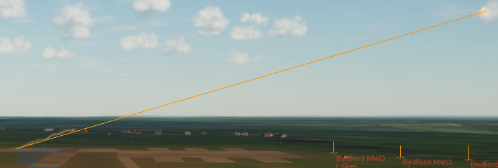
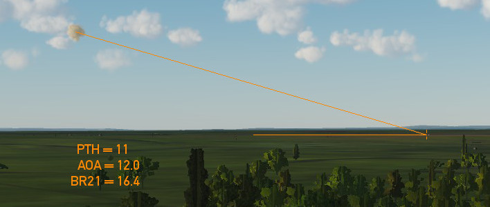
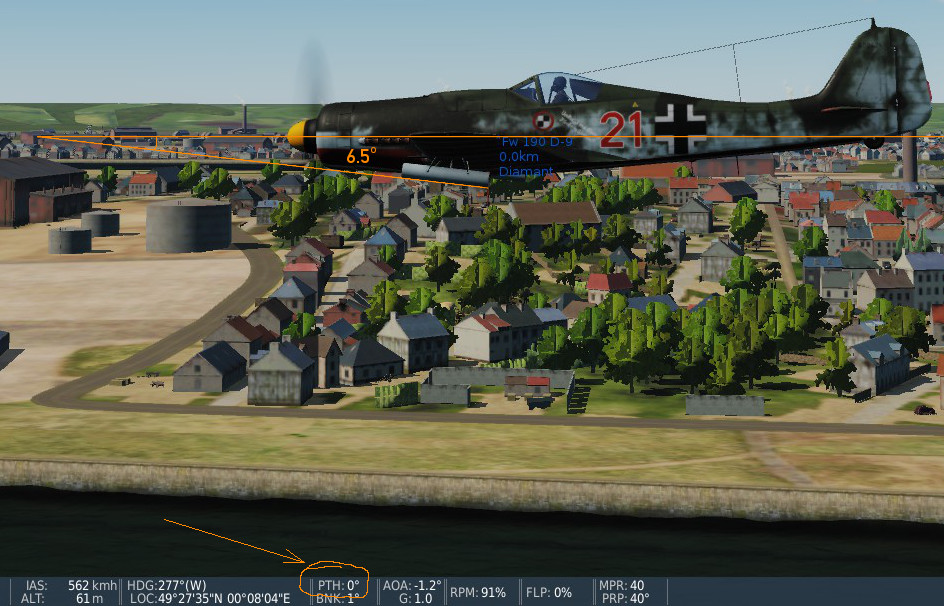
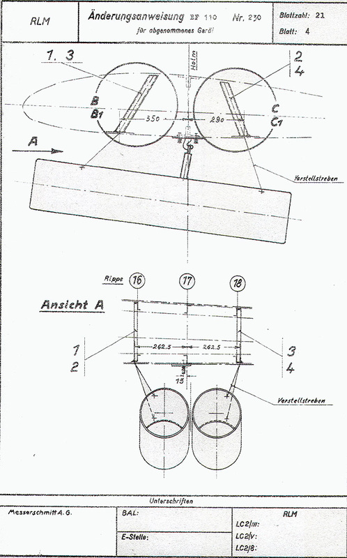
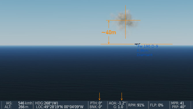
I have been experimenting with the 21cm Bordraketen (BR21 rockets) on the FW 190 D-9 (DCS v2.5.2.18521) and I believe that the trajectory may be incorrect. Evidence br21_testfire_1.jpg -- In this first test, I use lorries placed at fixed distances and use this to calibrate the image. By analysing the frames of some video footage, I could determine that the fuse from firing to exploding is exactly 3.0 seconds. The travel distance is approximately 762 metres, which gives a velocity of approx. 254 metres per second. This is slow compared to the reported values of 320 metres per second. The range is low, but if the speed of the aircraft (say, 500 km/h) is included, then the values are roughly correct. What is not consistent, however, is the trajectory. There appears to be no "drop". Although the BR21 was spin-stabilised (using angled rocket motor apertures), there should still be some drop (and this is mentioned in the sources I have found). This also accounts for the reason for the upward angle of the launch tubes. br21_testfire_2.jpg -- This second test compares the angle of the fired rocket from a stationary FW 190 on the ground. The pitch and AoA of the aircraft is such that the measured angle of the rocket compared to the aircraft is approx. 5.4 degrees. br21_fw190a8.jpg -- The angle of the rocket in DCS (5.4) is extremely close to the measured angle of the rocket on the FW 190 A-8 (approx. 5 degrees). Yes, I am aware that the use of the BR21 is anachronistic when used on the D-9, but the implementation should be the same as the A-8. br21_schematic.jpg -- Here is a plan confirming the 5.2 degree angle. The schematic is actually for a Bf 110, but the result is essentially the same as what I can discern from photographs of units mounted on FW 190 aircraft. br21_mount_angle.jpg -- Confirmation that to first order, the mount angle is correct (the FW 190 in the test was carefully trimmed and flown with vertical velocity = 0.0). Note the angle, but also the variation between the pitch and the AoA (which accounts for the 1 degree discrepancy). The effect br21_explosion_alt.jpg -- However, as indicated by the first two images, there is no "drop" during the trajectory. The rocket flies in a straight line at the upward included angle. This results in the effect shown in this image... even when flying carefully trimmed and flown with vertical velocity = 0.0, the rocket will explode high above the flight-line of the aircraft. Summary The BR21 rocket tubes are correct on the aircraft. However there is no "drop" of the rocket itself during its trajectory. As a result, the rocket explodes far above the aiming point. This is inconsistent with the historical records for this weapon. The range of the rocket seems low but, unlike the incorrect trajectory, I do not have enough evidence to state whether it is correct or not (but I mention it, in case it is somehow part of the trajectory issue). References http://www.lexikon-der-wehrmacht.de/Waffen/raketenwerfer.htm http://www.nevingtonwarmuseum.com/werfer-granate-21.html https://en.wikipedia.org/wiki/Werfer-Granate_21
- 25 replies
-
- 11
-

-

-
Similar to the thread on German WW2 Ships, I'd like to ask about Allied ships. Specifically warships. At the moment, we have: LCVP Higgens landing boat LST Mk II landing ship USS Samuel Chase Certainly the latter two allow the making of the semblances of a trans-channel convoy. You can use the Dry Cargo Ships (Ivanov and Yukushev). There is also a tanker (Elnya), which vaguely looks like a T2 Tanker (without the mid-ship bridge). It would be convenient for these three to be added to the USSR roster, so we get them by default on the Allied side for WW2 mission builders, although at least there is a work-around (just remember to add "Russia" to the Allied coalition when building the mission). However, what is missing is some form of warship. Even just one design would be extremely useful for putting together convoys, landing forces, shore bombardment and docked naval forces. Yes, there are some destroyers in DCS, but they are all Cold War or Modern and are armed with surface-to-air missiles. :eek: Some RN or USN escort ship of WW2 vintage would be really nice! Some examples: USN Gleaves-class destroyer RN Hunt-class destroyer RN U-Class destroyer (alternatively S, V or W-Classes) RCN Flower Corvette Ref: https://en.wikipedia.org/wiki/List_of_Allied_warships_in_the_Normandy_landings#Destroyers_and_escorts Any chances?
- 1 reply
-
- 1
-