
Akiazusa
-
Posts
291 -
Joined
-
Last visited
Content Type
Profiles
Forums
Events
Everything posted by Akiazusa
-
You don't need to press that Engine Shutdown button when starting the engine. You only press that button when you are going to shut down the engine. By the way what's the position of your Ignition/Ventilation switch when you attempt to start the engine? It's a 3 positions switch below to fuel pump switches. Make sure it's not in the VENT position.
-

Is there any afterburner gate like F-14/F-16/FA-18?
Akiazusa replied to VR Flight Guy in PJ Pants's topic in M-2000
You mean detent fingerlifts ? I haven't find one. But I think you could custom the throttle range for afterburner in the special settings as an alternate. -
How to find desired course in CDU?
Akiazusa replied to EagleBeak's topic in DCS: A-10C II Tank Killer
glad it helps you -
How to find desired course in CDU?
Akiazusa replied to EagleBeak's topic in DCS: A-10C II Tank Killer
I recorded some short tracks, showing my steps of setting it up.Don't know if they could help. 2 ME preset waypoints +1 cockpit added waypoint,using TO-TO and VNAV in different mode. TO-TO and VNAV,FLT PLN mode .trk TO-TO and VNAV,MISSION mode .trk I put 2 waypoints using the ME,one was lined up to the runway,the other one was directly at the runway,then using TO-TO and VNAV did a kinda crazy approach in fog. TO-TO + VNAV landing in fog .trk -
How to find desired course in CDU?
Akiazusa replied to EagleBeak's topic in DCS: A-10C II Tank Killer
Hi I just tried it, and it works correctly for me. Most of your steps seems fine,except "Go to the "attributes" page and switch to STEER mode to "TO-TO"" The TOTO/2D/VNAV you select on the attributes page only decides what default attributes will be used for you next new created waypoint,it won't change the attributes of existing waypoints You may need to click into your flight plan page and click under each waypoint to make sure they are already in TO TO mode if you are in Flight plan mode or you need to click into NAV-Waypoint page to make sure they are in TO TO mode if you are in MISSION mode And also the attributes for a waypoint and "the same waypoint but in the flight plan" can be different,you need to check them both if you want to switch between FLIGHT PLAN and Missions. I didn't fly the A-10C recently,but I used this function a lot back in the days ,also the VNAV function. I just tested both of them and they both works. -
Don't forget the sensors of Missile approach warning system are on the wing tips,you can't just hang a AA missile on a sensor,right?

-
Maybe due to the wind? IIRC it won't compensate for wind(at least in our game),unlike most other full fidelity jets.
-
Refuelling probe "EMERGENCY EXTD" position?
Akiazusa replied to Willie Nelson's topic in DCS: F/A-18C
Normally the probe is powered by HYD2A When using EMER position,it opens the emergency air refueling probe selector valve and the APU arming valve (which will connect the APU accumulator to it)and extends the probe with APU accumulator(which is pressured by HYD2B or a hand pump) . Retains all other functions as the EXTEND position. -
Спасибо, я попробую это. Есть кнопка KC, я думал ее координаты будут использоваться для выставки. Думаю, я ошибаюсь. В дальнейшем буду пользоваться корректировкой ориентаций. еще раз спасибо
-
И еще кое-что. Перед последним обновлением я мог установить целевую высоту ОТ (оперативной точки), установив "Кремальера установки высоты аэродрома" ("Высотомер механический"). Но я не могу сделать это сейчас. "Шквал" всегда будет указывать на точку ОТ, но на уровне моря. Это новая функция?
-
Как я могу изменить текущий координат перед выставкой? Например, я летел из аэропорта А в аэропорт Б, затем полностью выключите самолет. перевооружаться и дозаправиться, затем снова запустить самолет. Но Инерциальная навигация уже дрейфовать. Я хочу изменить "текущий координатор" Инерциальной навигации на мою правильную координату вместо уже дрейфующей координаты В документации не увидел явного раскрытия этого момента (или проглядел).
-
Sorry,I didn't express clearly. But I mean when using fast or normal INS alignment on the ka50,it requires a heading value which is accurate to one decimal place to be input to the NAV computer after alignment to tell the computer where you are pointing. This step is not required on most other aircraft's INS in DCS since the computer will figure out where it's pointing by themself. 1° error could make the INS drift to somewhere makes no sense and cause trouble especially when you are trying to slave your target camera to a target point.(for example you know there is a enemy SPAA at the west-end of a village,you put the exact coordinates of it into your INS and slave your target camera to it,and the target camera point to the east-end of the village......) On the ka50,only by doing a full precise alignment will the INS find out where it's pointing by itself. But it takes nearly..... half hour...........(compared to 3 to 8 mins on most other DCS aircrafts)you won't want to align your INS in that way everytime ,trust me...
-
I like this idea. But there is a problem,the heading readout via that window or the "F10 map ruler" is always rounded up to an integer. We need a heading value which is accurate to one decimal place
-
Deka Simulations announces the DCS: J-8II for DCS World!
Akiazusa replied to Mike_Romeo's topic in DCS: J-8II
You completely forget how DCS World started,or the first aircraft in game with Advanced Flight Model back in Lock On times. -
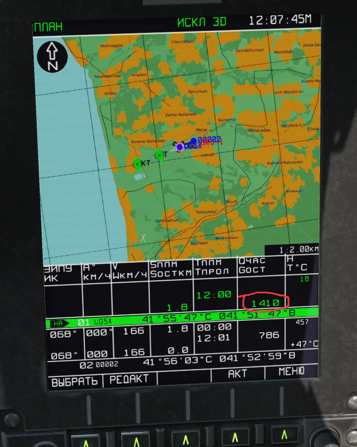
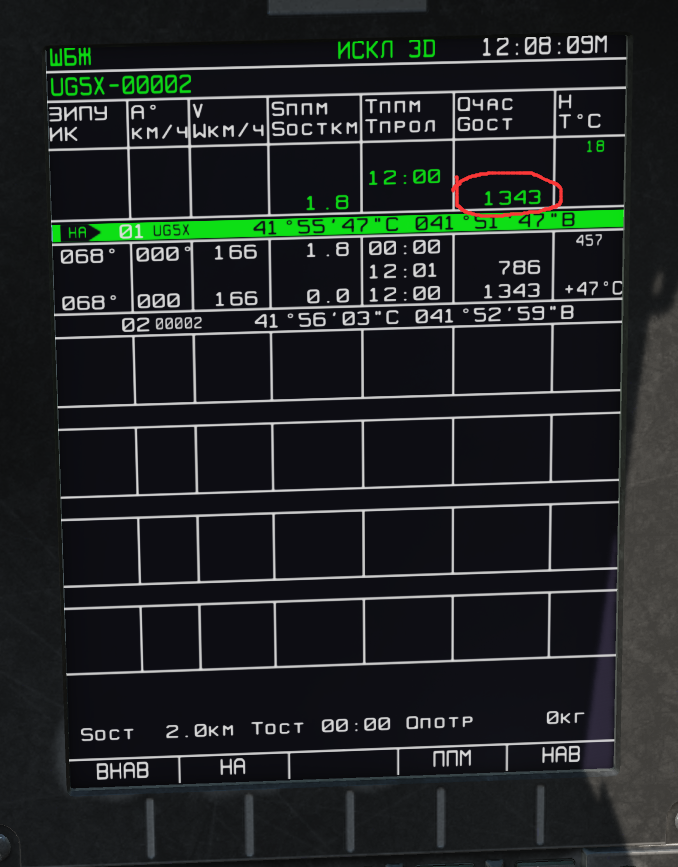
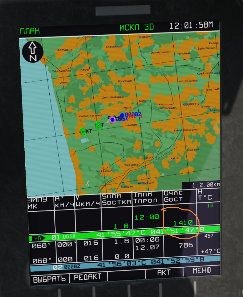
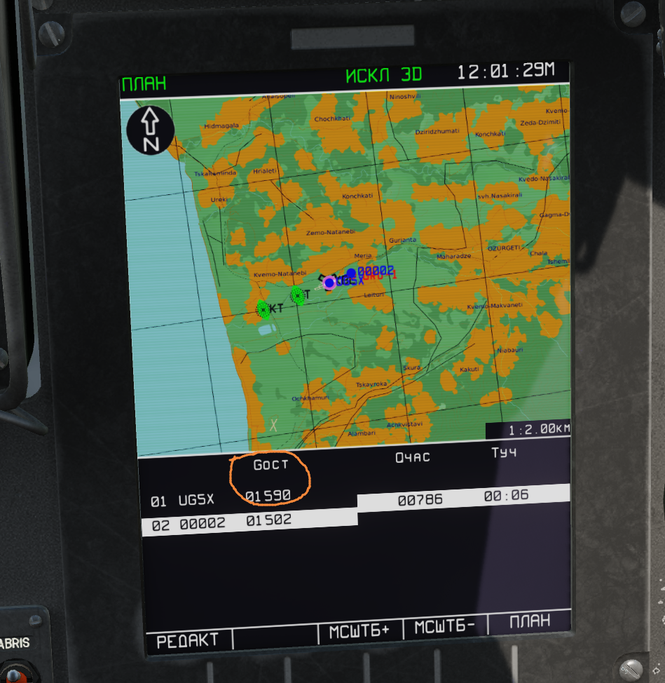
Привет Можно ли как-то обновить значение остатка топлива (Gост) (отмечено красным кружком)на АБРИС? Значение Gост, которое я установил для первой начального ИПМ на странице топлива, похоже, не влияет на нее. Я меняю значение на 1590 на странице топлива,нажимаю кнопку AKT, но оно по-прежнему показывает 1410 на странице ПЛАН и странице ШБЖ
-
Thank you for the info,Hobel. It's nice to hear that. I just gave it a try and it seems that the DISS only do the "warm up part" thing when the wheel is on the ground. And only start illuminate radiation when all the 3 wheels are off the ground. Maybe it's to avoid electromagnetic radiation to the ground crew? I find a line saying "Do not stand within six feet of transmit antennas when Doppler system is on. High frequency electromagnetic radiation can cause internal burns without causing any sensation of heat." from the TM1-1520 Mi17 manual Anyway the error in fast alignment is huge(just like using the NAV system on the MI8 and Mi24),and the system will switch to AIR DATA mode anyway when you bank/roll is above 10° .So I think I can accept that small error caused by DISS during takeoff if I'm ever going to use the fast alignement in the first place.
-
Empty external tank leads to an error in the weapon control panel (PCA)
Akiazusa replied to felixx75's topic in Bug Reports
From their discord,it will be fixed in the next update Also there is a temporary fix if you want,but it will break the IC check for MP. Fix file link(to the Razbam discord) https://discord.com/channels/536389125276827660/544227358429675531/1068906304988528711 -
Is the wind calculation taken from INS too? Maybe it will start working when the INS is fully done.
-
How to activate shkval with yellow sight thingy?
Akiazusa replied to e32lover's topic in Controller Questions and Bugs
You can ask the ground crew to replace the NVG to the HMS,it's default to NVG when the mission start at night (20:00 to 8:00 as Vital said) Although the mission designer can force it to start with NVG or HMS regardless of the time of the mission Just change it via the "\" ground crew menu before start up the engine. -
reported Some format misalignments in ABRIS
Akiazusa replied to Akiazusa's topic in Bugs and Problems
Thank you Flappie -
fixed CTD when trying to edit GNSS elevation mask
Akiazusa replied to Akiazusa's topic in Bugs and Problems
Thank you! -
Wishlist for potential planes after JF-17
Akiazusa replied to J-20's topic in Deka Ironwork Simulations
Can you guys stay on the topic and keep this political bullsh** away from the forum. -
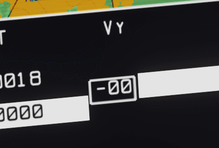
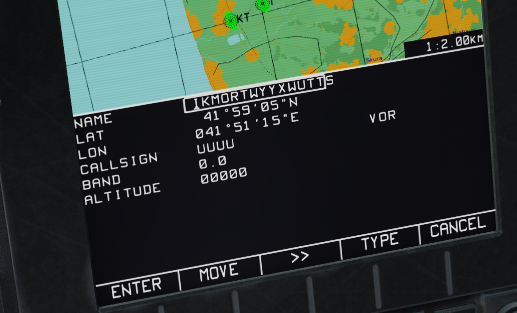
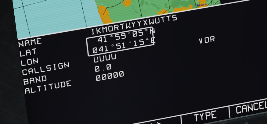
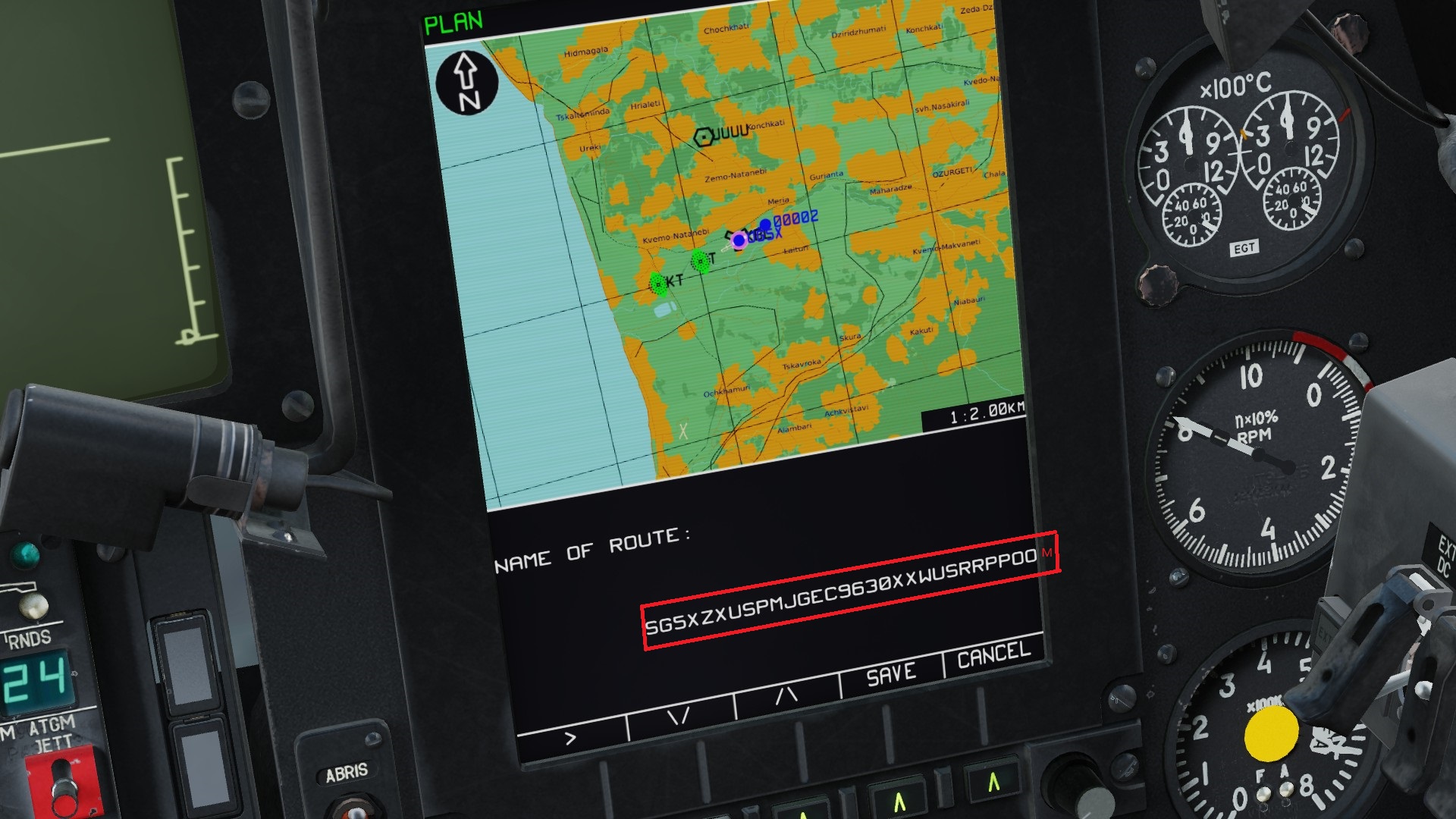
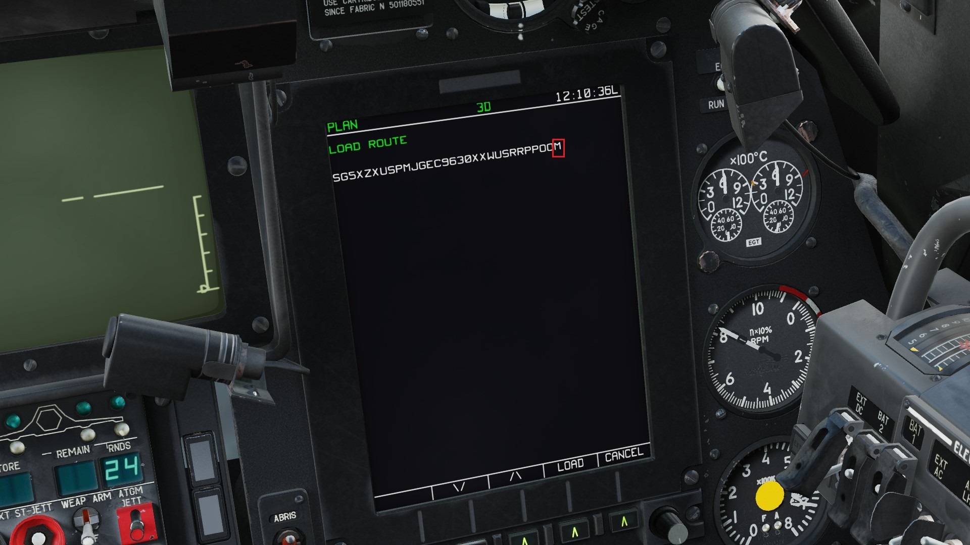
Hi There are some small issues in ABRIS format 1.The ABRIS editing line for Vy under FPL-VNAV page is misaligned. ABRIS editing line for Vy under FPL-VNAV page is misaligned .trk 2.The "editing box" for Info point name and coordinates under "ABRIS-PLAN-Addition INFO" is placed too left,causing misalignment.(with the maximum length of info point name reached) editing box forI nfo point name and coordinates is misaligned .trk 3.When saving a route,the name of route is placed too right,and causing the last letter of the route name out of the screen(with the maximum length of route name reached) last letter in the name of the route out of screen .trk They are just minor details,but hope they could get fixed. Thanks
-
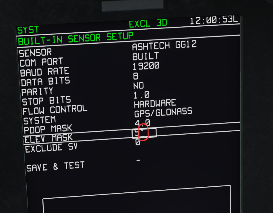
Hi I noticed when you trying to edit GNSS elevation mask under the ABRIS-MENU-GNSS-SYST-BUILT page,if the value of this line is below "10",then you can directly move the editing line under the degree "°" marker(it's not possible when the value is equal or above 10),and if scroll the ABRIS Cursor manipulator knob conterclockwise when the editing line is under the degree "°" marker ,the game will crash However if you scroll the knob clockwise when the editing line is under the degree"°" marker,everything works fine. Crash log: dcs.log-20230206-105901.zip Hope the team could take a look,thanks
-
Yes,I think this should not happen either in theory,but I'm not sure.