skywalker22
-
Posts
2360 -
Joined
-
Last visited
Content Type
Profiles
Forums
Events
Everything posted by skywalker22
-
Now I have constant 72 fps thx so much mate, really appreciate your help.
-
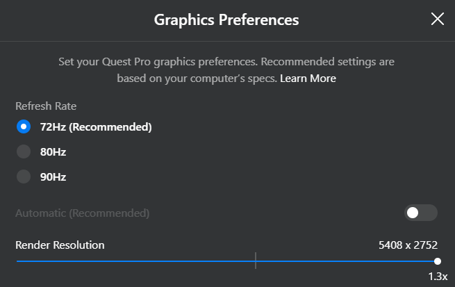
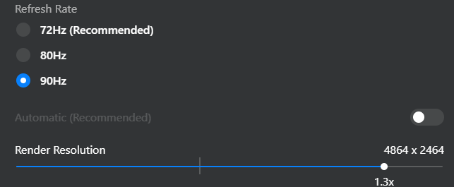
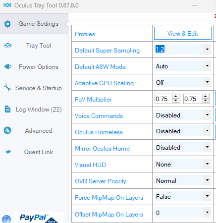
So this PD in OQL to 1.3 and both others (in DCS and OTT on 1), right? in OTT on 1:

-
Its 1.0
-
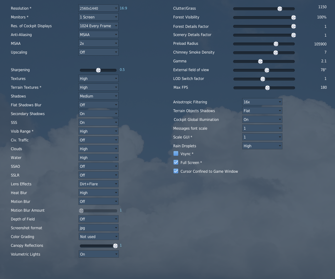
I have, 3rd pic 3 posts above. In OpenXR Tollk have these settings: CAS upscaling Inner ring 60% Middle resolution 1/2 Outer ring 75% Outer resolution 1/8
-
Thx, will do as you told me. Btw, Can you show me your Nvidia 3c settings of DCS? Those are still on default. I frogot to save them (or write them down, before reinstalling new OS).
-
I don't have them maxed out, far from that. As said, all these settings, I used to have at least 50% of the time 90 fps with previous system (10700k). -- Can you show me your Nvidia 3c settings of DCS? Those are still on default. I frogot to save them (or write them down, before reinstalling new OS).
-
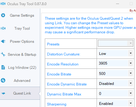
ASW... I remembered, its in OTT app, I have it set like: And this is how I have it set exactly before (in the old system).
-
Meta Quest Link But as said, VR can do a constant 90fps, which I am gettihg in Le Mans Ultimate racing simulation.
-
Is that in DCS? Before I had 90fps with old system (intel 10700k) and didn't touch a thing in DCS.
-
Btw, and how will I know if the system is performing as it should? Sorry, never done that before
-
Not yet, will do it now. In Le Mans Ultimate it runs perfectly fine at 90 fps in VR. And the game is very demanding.
-
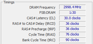
1. For Memory I have chosen EXPO (for AMD, or is it not OK, should I choose XMP?). 2. cooling is ok, cpu is max up to 48 degC, GPU max 45 degC. 3. MSI X870 Tomahawk MOBO has 5.0
-
Using same old settings for 4090 in game and in OpenXR Toolkit (before with intel 10700K, and now AMD 9800X3D). In OpenXR toolkit I have these setting: CAS upscaling Inner ring 60% Middle resolution 1/2 Outer ring 75% Outer resolution 1/8 -- Before with an old CPU it was mostly running with 90fps, and now with 45fps allover. What could be the reason for not having 90fps with state of the art hardware? Also fresh installation of OS Win11 with latest Nvidia drivers and up to date BIOS (for MSI X870 Tomahawk MOBO).
-
MSI Afterburner monitoring features causes the dips. I turned them all off, and dips are gone.
-

Is the texture resolution increased by 400%?
skywalker22 replied to LucShep's topic in DCS: MiG-29A Fulcrum
400% means 4-times more. Which is practically nearly impossible. NM textures by now are 4096x4096 (up to 30MB) as far as I have seen. So having 4-times bigger? Come on.... would be also completely useless. All over-ground objects look like they are made 10-15 years ago (mostly are squares with low poly textures), so why making some aircrtaft looking so much better? Waste to time and pc resources. I hope this is typo. -
I have VR headset (Quest Pro) as well, but still didn't try it yet in VR. So far only on monitor. I also have steady 180 fps and 5-6ms FT. But here and there I have these dips as mentioned. I have a clean Win11 (on new M.2 ssd) and new latest Nvidia drivers for 4090. What I did in BIOS is PBO undervolt it a bit (-20). For example, I also do car sim racing, and game Le Mans Ultimate runs with no issues what so ever in VR and also in 2D.
-
From AMD7800X3D to 9800X3D, stutters!!!
skywalker22 replied to motoadve's topic in PC Hardware and Related Software
I am also getting some fps dips here and there. fps can drop way under 100 for a second. And what I did in just undervolt it in bios (-20). Do you think it might cause thsese dips as well? Else its all on stock settings. How much did you overclock? Does the temp rises with it? -
Got 9800x3d (in combo with an "old" 4090), optimized it as much as I know (with no overclocking). And I get stutters here and there. Don't know what would be the reason for them. Anyone else have/had stutters? But I guess its up to DCS now. Its not like stuttering, but game just like freezes for a second. Fps drop way bellow 100.
-
24.03.1999 - Mig-29 combat flight - Iljo Arizanov
skywalker22 replied to okopanja's topic in DCS: MiG-29A Fulcrum
I would say AMRAAM didn't have the advantage, it did, but what was decisive was there was no SA what so ever for the Migs. If you don't know whats going on around you, it's hard to fight, it's like fighting the ghosts. And there was so little number of Migs as well. If the Serbs would have lets say 100 of them, this would be a different story. And also the lack of ground support as well. And as you mentioned, bad maintenace was also a major factor of at least properly using the Migs and their capabilities. ps: so cool to listen to those pilots, some interesting storries. Like this example (NATO pilots learned Serbian langauge) -
24.03.1999 - Mig-29 combat flight - Iljo Arizanov
skywalker22 replied to okopanja's topic in DCS: MiG-29A Fulcrum
Has any Mig-29 ever fired a missile towards Nato fighters in this 1999 conflict? Based on the SA of Mig-29 and F-16 (or what ever fighter jet NATO used at that time), I would say they shot exactly none. I wonder why they even got airborn, knowing they had very little chance of surviving, and even less firing towards enemy fighter jets. But a very interesting story of very brave pilots, hats off to them. -
Has there been done anything on AMRAAM to get HPRF stage? It's been quite a while the missile has got any significant improvement.
-
BAD, really bad. Surface mesh (sorry but I have to say) sucks, specially now what we can see on Iraq map. They need 100% remaster it. Example of bad modding (its been a looong time, but nothing has changed): Take this as an example:
-
Hi, I will change all main three components in my PC (mobo, cpu and memory), I am wondeirng whats best to do, what do you recommend. Complete new install of Windows, or not? Some say that Win11 are smart enough to fix all issues regarding the swap, but I'm really not that convinced yet. Personally I would go old school and install new windows, although I don't like to from many many reasons. What do you say guys?
-
All seems and feels smooth, no issues what so ever. ps: but I'm on Quest Pro, which I think shouldn't make any difference.
-
Exactly, I had to lower it down to 500Mbps.