
tugais
-
Posts
232 -
Joined
-
Last visited
Content Type
Profiles
Forums
Events
Everything posted by tugais
-
This is excellent work, congratulations for the results and thank you for the time you spent on those textures. However, did you know that at some point the external textures will have an overhaul by Razbam to catch up on the latest modules released ? Just to let you know, in case you weren't aware of the information.
-
Razbam, le développeur du module est bien au courant des soucis causés par les dernières mises-à-jour et la personne qu'ils emploient pour réaliser ces missions devrait bientôt mettre à jour le cursus (il l'a annoncé sur le forum mais aussi sur le serveur Discord du développeur). Par contre il ne faut pas espérer une refonte complète des missions d'entrainement, juste un rafraîchissement pour coller aux dernières nouveautés.
-
This is nicely done, the quality seems top notch ! When referring to animation, do you think you could enhanced what's actually in the game and offer something similar to another highly animated pilot released not too long ago in another plane ? Just a wish :x
-
Zhukov has no emotions, it is known.
-
It would be a very popular theater for sure, but the current engine cannot handle such a huge amount of 3D objects. Perhaps when ED will develop a new engine for DCS.
-
Twitch is a live streaming platform, its purpose is to provide actual unedited gameplay. For something more polished you still have to rely on Youtube. It was a cool stream. Thank you for sharing it.
-
Yep, the Mirage is clearly one of the funniest module to fly. It's easy to learn and to operate and I think it's an excellent introductory module to DCS. If you tend to fly different modules, the Mirage will be a breeze of fresh air and you will enjoy her a lot ! On the downside, I won't go that far in saying that this is the best DCS module. We still have a lot to do regarding system implementation and radar operations. Elwood has already acknowledged the current radar issues reported by several key members of the Mirage community but at the present time he has to work on something else. Once you get past the first few hours and have a need to take the plunge into the study sim aspect, you will get stuck. We need to cross our fingers and hope for a conclusive year 2020 for the Mirage. I didn't fly the Mirage for a month and consequently could not fly at all on DCS, I miss her. Bring her back please !
-
I was indeed talking about Damcopter. I won't say a thing about your process as it is in my opinion the best way to go, asking to various pilots who flew the machine to give their opinion. In the end, the most important thing is that your team accepted to revisit the flight model and update it in the future. Everybody wins !
-
To be honest, an actual Gazelle pilot and instructor from the ALAT (Aviation Légère de l'Armée de Terre | French Army Light Aviation) expressed the same concerns several months ago but after several tries to convince the team he just quit these forums. He's still active on a french website though. The good news is that Polychop will revamp the flight model in the future. From what I read lately the ALAT is nevertheless ramping up its deployment of the Polychop's Gazelle to train their pilots thanks to this same instructor.
-
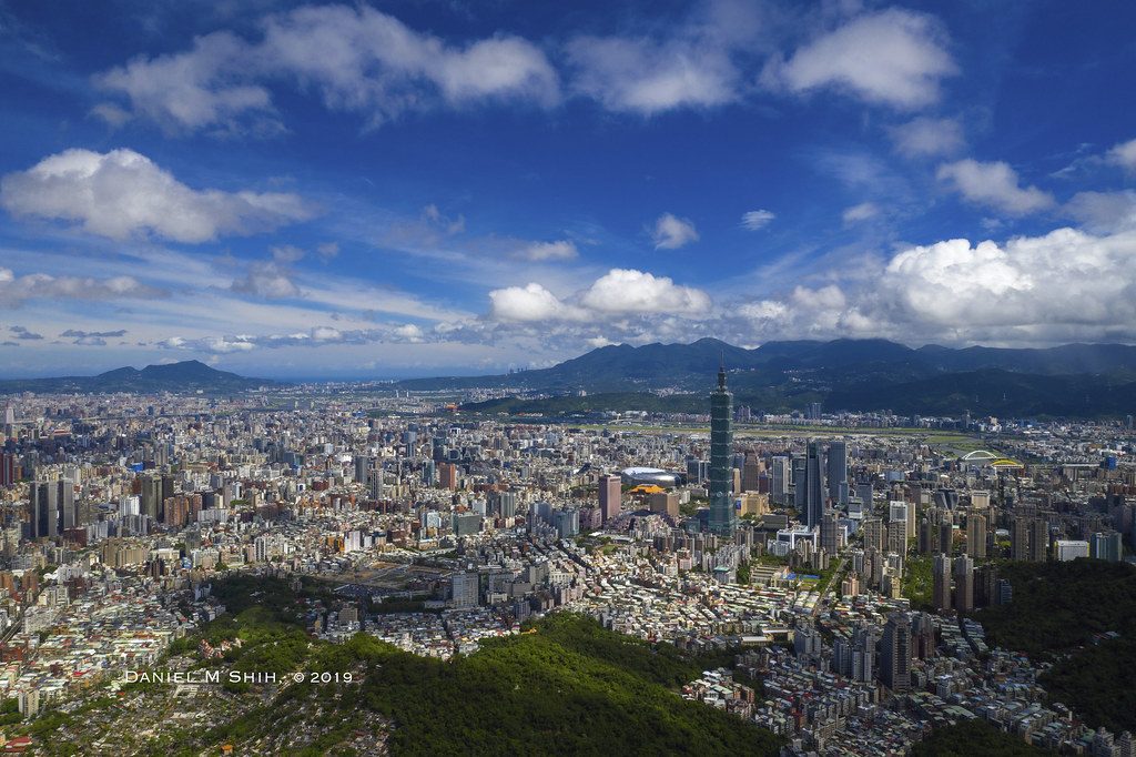
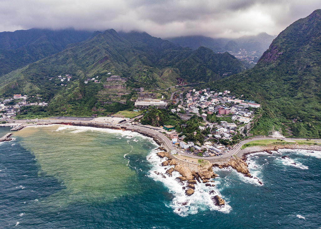
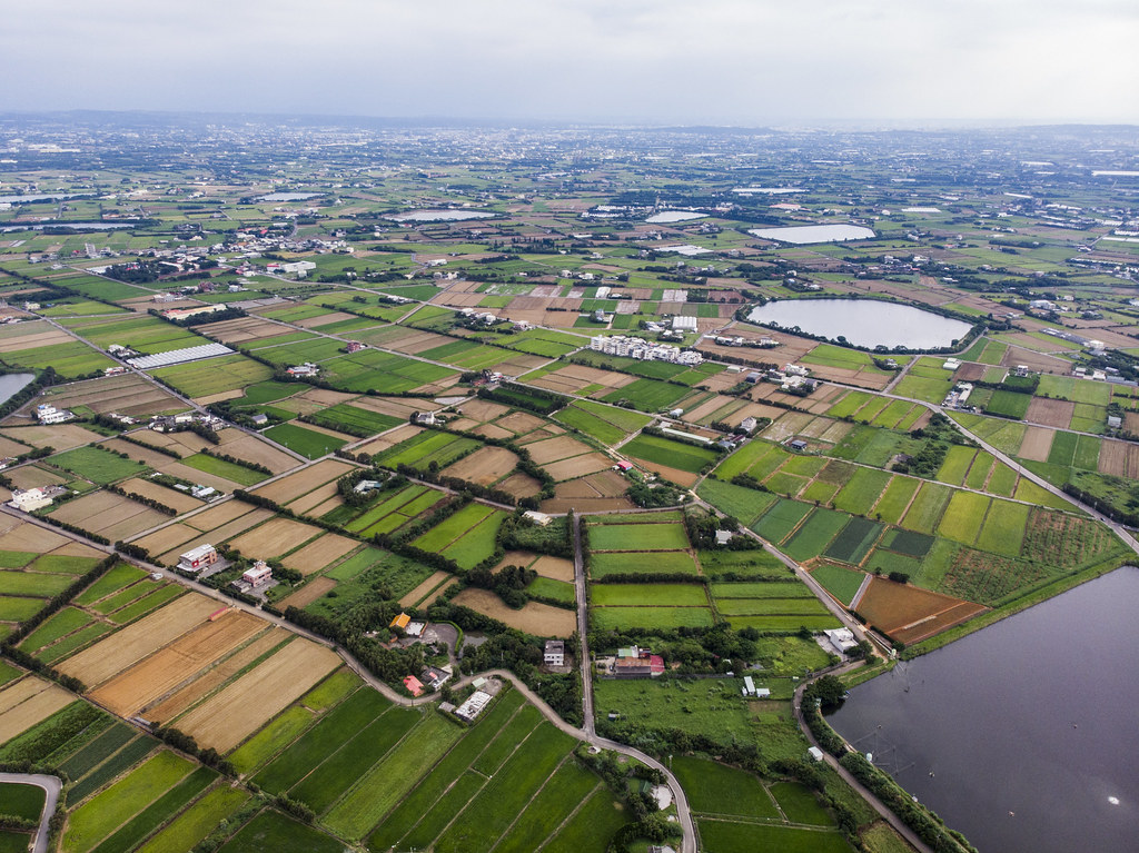
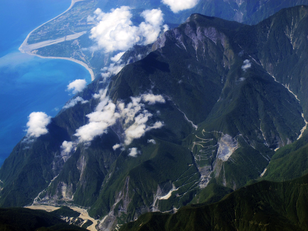
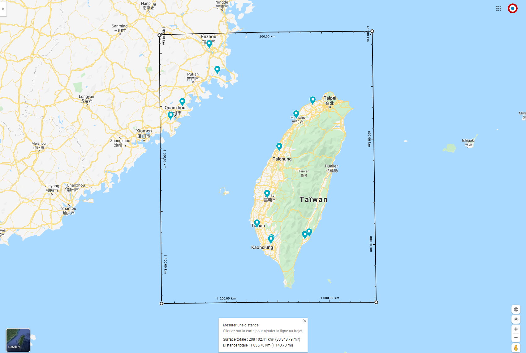
Hello guys, I wanted for some time now to share my interest for this region located in East Asia and build a case about its relevance in our sim. First of all, let's present Taiwan. GEOGRAPHY Taiwan measures 35,808 square kilometres (13,826 sq mi) and lying some 180 kilometres (112 mi) across the Taiwan Strait from the southeastern coast of mainland China. The East China Sea lies to its north, the Philippine Sea to its east, the Luzon Strait directly to its south and the South China Sea to its southwest. The main island is a tilted fault block, characterized by the contrast between the eastern two-thirds, consisting mostly of five rugged mountain ranges parallel to the east coast, and the flat to gently rolling plains of the western third, where the majority of Taiwan's population reside. There are several peaks over 3,500 m, the highest being Yu Shan at 3,952 m (12,966 ft), making Taiwan the world's fourth-highest island. The eastern mountains are heavily forested and home to a diverse range of wildlife, while land use in the western and northern lowlands is intensive. My proposition of a DCS : Strait of Taiwan map. The area covers 220.000 square kilometres, that slightly more than the actual 200.000 square kilometres of DCS : Persian Gulf. The blue dots accross the map are actual PLAAF (People Liberation Army Air Force) and ROCAF (Republic of China Air Force) Air Bases. The island of Taiwan offers a great topography that can be seen in these photos : GEOPOLITICAL BACKGROUND The ROC was set up in Taiwan when Chinese nationalist leader Chiang Kai-shek and his army fled there in 1949 after his government was defeated by the communists on the mainland. The United States eventually withdrew its recognition of the ROC government on Taiwan (as did most countries) when it recognized the People’s Republic of China in 1979. However, Washington also signed the 1979 Taiwan Relations Act that called for the island’s future to be determined “by peaceful means” and promised to provide Taipei with defensive weapons Ever since 1979, the ROC has existed in a sort of gray zone. Beijing and Taiwan eventually adopted a fuzzy formula, known as the 1992 consensus, in which each side claimed to be the legitimate government of one China. That consensus eroded over time. Beijing redefined it as “one China, two systems,” meaning Taiwan could maintain its democratic system but under Beijing’s overlordship. MILITARY BACKGROUND China, as part of its continued military expansion, has deployed missiles along the Taiwan Strait and periodically conducts drills near the island. It has sent bombers, fighter jets, and its aircraft carrier over and around the strait as shows of force. According to a 2018 U.S. Department of Defense report, China’s military, the People’s Liberation Army, has “continued to develop and deploy increasingly advanced military capabilities intended to coerce Taiwan, signal Chinese resolve, and gradually improve capabilities for an invasion.” In response, Taiwan continues to purchase weapons, primarily from the United States. Between 1979 and 2018, Taiwan ranked as the ninth largest recipient of arms globally. During the same period, the United States supplied more than three-quarters of Taiwan’s imported weapons, according to the Stockholm International Peace Research Institute’s arms transfers database. DIGITAL COMBAT SIMULATOR RELEVANCE Considering all the informations above, the DCS : Strait of Taiwan map would offer a very interesting and challenging environment to DCS players. Players would be able to use a wide variety of aircrafts that would easily find their place in this contested area. Taiwan's ROCAF actually has in its inventory F-5s, Mirage 2000s, F-16s and a massive amount of US hardware. China's PLAAF could use the J-11, the JF-17 and a lot of Russian hardware that has been localized by China Su-33/J-15, MiG-21/J-7, MiG-19/J-6 and the ever expending China Asset Pack. This map would offer various types of operations : Carrier Operations Amphibious warfare High intensity engagements over the plains of the west coast Guerrilla warfare in the eastern mountainous jungles Last but not least, this map would be perfect for tourism with gorgeous vistas. --- I do realize this map would be a major endeavour for any developper. Aside any political concerns, I truly believe DCS : Strait of Taiwan would be a fantastic choice for any developper. It would be a welcome change of pace with the latest productions mainly based in a desert area (Nevada, Persian Gulf, Syria). Thank you to anyone who read this post and support the idea. Sources used for the redaction of this topic : Wikipedia FlickR The Philadelphia Enquirer Council on Foreign Relation

-
Some time ago, on this thread or another one where a lot of suggestions were made by community members, Wags intervened and told that he didn't read the right answer. Hawaï and Korea were among these suggestions so I suppose we can forget these theaters as the next free map. Guadalcanal would be great for a WWII context but it would not fit a modern era. Guam was a strategic position that saw combat in 1941 and 1944 during WWII and still has significance today. The Mariana Islands could be a good candidate. My most anticipated theater would be Taiwan ; the island serves perfectly all the scenarios. In WWII when the Island was called Formose and nowadays as a growing possible flashpoint between US and China. Taiwan operates Mirage 2000, F-5, F-16, a growing number of US hardware and will welcome US warships in its ports. On the opposite side we have a J-11, a JF-17, the China Asset Pack with more and more hardware added to it. I do realize there is virtually zero chance this is the free map.
-
This is not a problem with the aircrafts but this is a current limitation of the engine to cast light on 3D objects. I think it was done at the time to spare ressources from our computers. The light you're seeing is just a brighter texture applied to the terrain if I'm not mistaken.
-
I am not sure to follow some of the comments made in this topic. Did ED changed something within Combined Arms ? There is already the possibility to take control of a JTAC vehicle and use it to designate targets. As there is already a basic implementation of controlling infantry though the use of manpads. Has something changed in this regard ? The request from BigNewy to the team would be a real novelty and a big step for Combined Arms, as well as an incentive to buy this module. But it means that some work need to be done for infantry movement. Hope something will come from the request no too far in the future (perhaps for the upcoming overhaul of Combined Arms ?).
-
It is not. Wags confirmed it is in the Pacific.
-
Yes, you need to buy the whole magazine, I payed 5,49€ for it. If you have an Android or iOS phone/tablet, you can download the PCPilot app and then buy the last issue from it.
-
The AMA is just out of date regarding this information as the latest issue of PC Pilot contains an interview with Wags. Just bought the online version of the magazine and read the article. Wags states, indeed, that the new free theater will be located in the Pacific.
-
Nine Line made a comment about it, a weathered cockpit will be available but probably as a paid DLC, ED is looking into it.
-
It's been there for a while, it was already depicted when they showcased the 3D model of the pilot last year.
-
It occurred to me that the Russian section of this forum is much more informative than what we have on the english speaking section. Not the first time I see this kind of discrepancy between the english and russian forums. I'd love that Eagle Dynamics would hire or task someone fluent in english and russian to bring over the informations provided to the Russian community.
-
One of the easiest and probably the most effective way to create trailers is to script way ahead what you will record by creating scenarios lasting 30 seconds or one minute top. By doing this, you will have a very short track file you can use at will without pulling your hair because you went too far and missed the spot you were looking for. With a clip of 30 seconds, you can reload it as many times as you want and try every angle you can think of. On the plus side, you will have far less chance to have a corrupted track file. I found that using this workflow will save you a huge amount of time - of course there's still a lot of work to do before even recording and then by editing all the shots you captured.
-
Considering there is absolutely no overlap between aircrafts modeling and map creation I can't see why they should stop working on a new theater. If I'm not mistaken, the person in charge of the map in not involved with the current planes sold by Razbam.
-
I've been playing with the mission editor this week and I could swear I saw the dirt walls in there. When I saw them I even thought about how nice it would be to use them as protection for Insurgent forces. I'll have to give another look tomorrow.
-
At the moment, the only release date is "When it's done".
-
A few weeks ago I was flying formation at Mach 2.3, FL400. Launched the game a few seconds ago and achieved the same result over the Strait of Hormuz. I'm running the stable release.
-
From what I read on Checksix (the main portal for french simmers), several people including the head of the project for the Armée de l'Air said that the main goal for them was to train actual pilots to procedures and not learning how to use the aircraft itself. While they agreed that the flight model is good they didn't said it was accurate, that's a big difference to be noted. But hey ! If it's good enough for real pilots, it's good enough for me. Razbam is doing a great job with the Mirage ; after a short hiatus they resumed their work and made the Mirage one of the most interesting plane to fly on DCS World. I don't think we should expect any change for the flight model, it would surely lead to disappointment.