All Activity
- Past hour
-

need track replay AI refueling broken
mArTiNkOpAc replied to mArTiNkOpAc's topic in Aircraft AI Bugs (Non-Combined Arms)
After update, the problem remains the same. I just went ahead and cloned the refueling mission and removed the AI flight that refuels prior to me. -
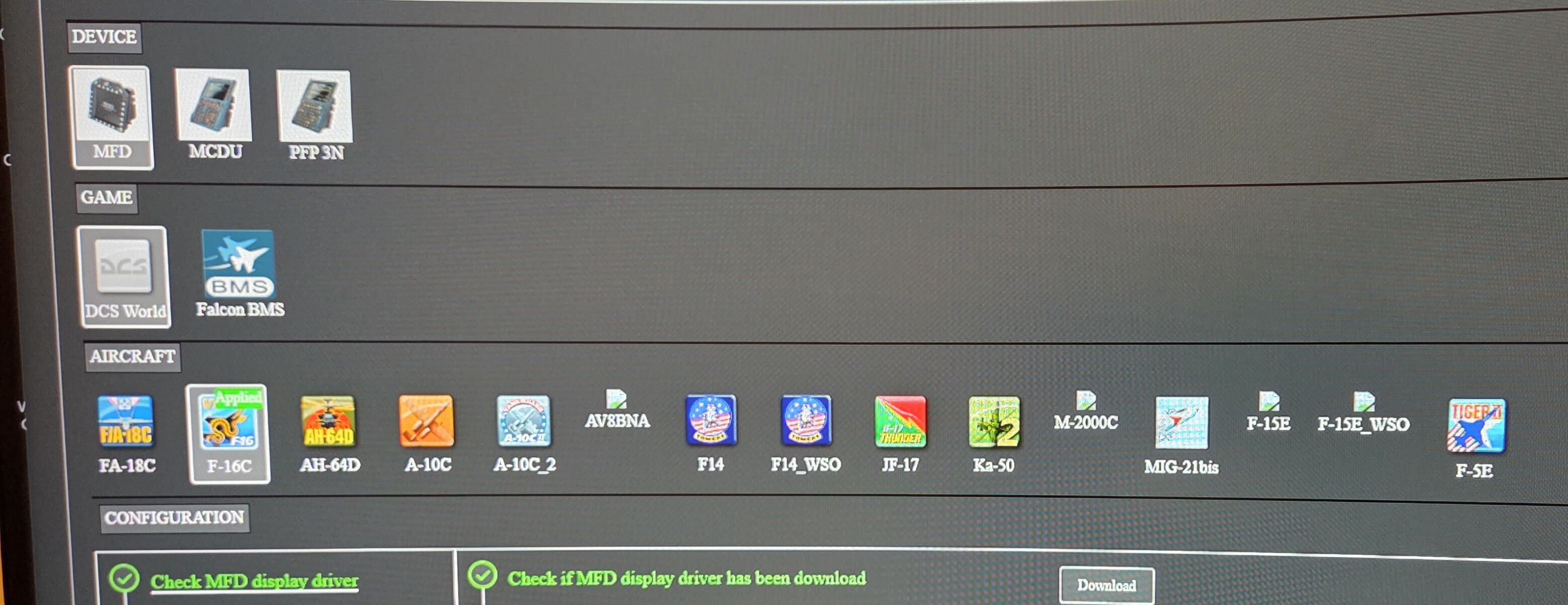
They still open in lower screen to select MFD location. I don't have these air frames so I don't know if they work or the icons is just missing
-

Inside wing texture missing when zooming out
Ghostrider 147 replied to Ghostrider 147's topic in Bugs and Problems
I noticed similar issues exist with the engine cowling and the supercharger intakes, when zooming out you can see “through” the aircraft just like here -
I noticed this yesterday. AV8BNA,M2000C,F-15E AND F-15E WSO.

-
There must be something else going on then, i just tried both PHS and FWD area again, both went on for minutes until i stopped them myself. No clue what could cause that behaviour on your side.
-
 The harm is hitting the point exactly. Its only variation of the hit is because it’s guided by INS not GPS. So it’s a bug from the patch
 -
i believe that they might not use high quality terrain/building textures in world map as that would easily take the size of the map above 200GB, the might use high quality terrain / building textures near the airfields and remaining be low to mid textures
-
As I've mentioned earlier MP servers don't exist in a vaccum and there is a lot of pressure from online community towards mission designers and admins. I don't like it, but it is a fact of life. People want to be aces and shoot lasers, so that they can land on home plate for tea and medals. If the sim offered F-35 along with Su-57 (not that it's possible), this would make more sense. No one's gonna fly a target drone for shooting practise.
-
Now that's a very weird interpretation of what @WHOGX5 wrote.
-

Pimax Super, order and delivery dates, please post.
Panzerlang replied to Panzerlang's topic in Pimax
I've given it a go in IL2. Apart from the auto IPD being a bit sketchy (I intend to set it manually next go, not sure how that's done yet though) it's quite impressive. Flawless performance at native res and 90fps (5090 and 9800X3D). The higher rez over the OG is noticeable and the colours are betterer. The sun though, jeezuz! -
I just ignore them. [emoji6] To be honest I never ever noticed it was there anyway, until someone complained about it. Actually, it's not here on the forum, only on the main site, right? Sent from my SM-A536B using Tapatalk
-
The search will turn itself off after 10s.
-
michele stefanini joined the community
-
 Calm down, son. Catch a deep breath rather than going full reheat against someone who started with "Apologies". Also, it is a legit question since this has been done for what, 17 years? You know, copy coordinates either directly from the game or to a piece of paper, plan before the mission itself on the F10 map, Google Maps, CFlite, and make your own spreadsheet. But you want something in-game, right? Is the ruler not enough? Drag a line and call it day. Why does that not work? You can also write the results on the canopy itself, instead of using openkneeboard. Actually, I will record a brief video to show you how you can open a map, drag a line, write two numbers. Already in-game, already in VR, takes a minute. This would be so much more coherent with your statement. Ad verbatim: > It would be most beneficial for just about every single phantom player that really wants to play with the module in the spirit of true gen 3 aviation. But I doubt you want that. In fact: > This is about getting basic information calculations into the kneeboard from the off, which is easy for a PC to do if you have known GPS positions. Having the bearing and distance to the next waypoint as part of the kneeboard would be invaluable. These are not really basic, but OK. If I understand correctly (my English is not great - "from the off"? Off mission, off track, off what?), you want something that knows your position as well. I thought we wanted a "true gen 3 aviation" experience here. Anyhow, since you want a GPS, the NS430 works perfectly (it also lets you cheat when updating the INS Fix, but don't tell any real pilot, they get mad because they never thought about it /s ). I have an F-4E/G EWO/WSO and a F-4F pilot who mentions that they used actual GPS in the Phantom in their career. If you want no GPS, then the solution is simple: INS, pilotage and DR. But I see it's not over: > It was then a logical progression to have a speed table to calculate times on the fly in a vertical column, or even two columns would make sense. Ok, now you want multiple speeds. So, to recap the necessary parameters to do what you want, we need: TAS for each turn/leg; Course for each turn/leg; AoB/G for each turn/leg; Altitude for each turn/leg; MagVar for each turn/leg; Wind direction/speed for each turn/leg. I can think of more parameters, but this should give a general idea. The first 4, besides the course, require manual input. Wind is interesting because it is a big factor that should be accounted for IRL. But wind changes. So, do you want it fetched in real time in DCS? What happens when the dynamic weather arrives? Anyway, the input part is getting crowded already. But then you want fuel as well. OK, easy to do. Should DI and weight be calculated in real time and fetched in DCS? Or at the beginning of the mission? Or at the first WP? Is the first IP the ingress/reference or just a turn? What if there is an AAR scheduled before or after? What if you are delayed? How do you plan for a dogleg/trombone fuel-wise? All these variables should be specified somewhere. This kneeboard is getting a tad tiny for the purpose. However, up to here, it's all easy. But then the problems start: DCS players. Imagine you build your mission and flight plan from the mission editor and share it. Altitude is 10,000ft, speed 360, 2000 ft 420 kts at the ingress, 540 kts at IP and delivery. Player A flies instead at 6,000 ft the whole mission and at 450 kts. The plan says he can make it fuel-wise, but he uses reheat for too long at departure, or perhaps loads a couple bombs more, and he runs out of fuel. The next thing he does is go and complain because the kneeboard doesn't work. I know because, throughout the years, I answered so many complaining about the AIM-54's crappy performance, when the fault was all theirs. The alternative would be to recalculate everything in real time: positions, timing, fuel, speeds, DI, wind, magvar, et cetera. Feasible for sure, but then you are asking for functions present in the modern Hornet and a GPS. Not really "gen 3 aviation" vibes here. Why not use the NS430 at this point? It is actually realistic past a certain time frame. The point I'm trying to make is quite simple: either devs make something very basic, like course and distance from the specified points and leave out player-influenced parameters, or you make a thorough tool. The former can be done already with no additional tools, both in VR and pancake, and takes a minute. Seriously, I'll put a video together when I have time. The latter requires more work, but this must not be on HB's shoulders. It should be a concerted effort driven by ED. There should be a proper planning tool before pressing "Fly", opening a mission editor-like page, where all the parameters can be set. A nice, full-screen tool, with all the appropriate parameters, where the members of the package can be specified and the plan shared (not only across groups, as on casual servers, this does not work), and so on. Something that works across modules, with the option of having Jester ready to input coordinates right after startup, and creates a series of reference kneeboard pages. Ideally, something that spits out something like this: https://flyandwire.com/wp-content/uploads/2025/04/low-level-planning-tool-launch-example-map.jpeg It is quite simple to do, in my opinion (but of course, I don't know what's under the DCS hood, so it may be very complicated instead). It's all a matter of resources, priorities, and time. ED already has a lot to do in this regard. Nevertheless, a planning tool, a TacView and LotATC equivalents should be part of DCS already. The in-game VoIP is a good first step, but it'd be great to see more basic functionalities "returning to DCS". Again, this is not a 3rd party's job to do, no matter how cool and sexy they are So, if you want something like that, I'm all aboard for it, just tell me where to sign. A kneeboard page instead is good to present an output, but there are too many parameters to be considered if you want to do a thorough job, and, imo, it is not worth the dev's time. What do you think?
 -
Hmm, i don't have those problems on my end. George announces that he has found targets (naval, ground, aircraft, helo, or fast mover), and i get the list of detected units (The list will only appear while the AI Context menu is open). My FWD Area search also continues forever until i command George to stop, or my pitch or roll gets out of a certain threshold. Not sure about PHS Area mode, but I'd guess it's the same.
-
fakemaverick joined the community
-
So I interpret that as "I think it's wrong, but clearly can't prove it and leave it at that"...
-
Count me in! We've seen the videos of crew members climbing out of the Apache. Hopefully all the groundwork has been laid to make these animations work throughout the sim, especially for soldiers and helicopters/transports.
-
*I don't speak English, this article was written using translation software, please understand if there is a misunderstanding.* I wanted to watch the replay while playing the DCS server, but it had a problem with its content logging. (Not how many minutes of delay is not recorded) I obviously played for a long time, and what I saw in the file was an abnormal file size. This issue is complicated and I can't explain it in the article, please download the accompanying logging file. This may be a problem that arises on my own, I want to know how to fix it, I have tried to remove all community mods, but it is not available. This file is client-side, and everything is fine with the file in the server. Tacview-20250728-015731-DCS-Client-简易多人-高加索训练任务+动态战役v4 Beta.zip.acmi
-
We have always had lots of sales, you are reading to much into it or to much reddit. DCS continues to grow and we continue to develop. thanks
-
waiting for resolution ED/RAZBAM Situation Info & Discussion
Shibbyland replied to NineLine's topic in RAZBAM
Yea I also thought the number of sales is getting excessive. At this point they may as well just make the sale price the actual price of their products and not have sales. It's a bit suss. - Today
-
I also think that the reason there is no information at all is most likely because they cannot afford to pay them. The fact that they had to extend the summer sale also leads me to believe that this may not just be the end of the Razbam modules.
-
Hi, I have absolutely the same problem. I checked whether other mods affect this behavior of the sighting system. I determined that they do not affect. This is a problem of this version and the developers should solve it.
-
Rockycoreforce joined the community
-
You'd potentially have no licence servers though if they went under. So it'd be dead to everyone in a week or whatever the maximum offline period is.
-

DML - Mission Creation Toolbox [no Lua required]
vgilsoler replied to cfrag's topic in Scripting Tips, Tricks & Issues
Thank you very much for DML and your support using it. Your experience and knowledge is unvaluable and a true loss for DCS Community. @BIGNEWY and @NineLine This is an example of how you should not act with the community. -
I'm glad it finally worked out. As one of the lucky ones who has been able to test the Super for a few weeks now, I can only say that it was worth the wait. Have fun unpacking and enjoy!
-
Hello everyone. I've been using Virtual Destop in Quest3 VR for DCS for five days now and I'm having a problem where something is restricting me from moving the cursor around the menu, and I don't know how to fix it. Could someone help me Please? I've attached a picture of the parts I can move the cursor around, and I'll cut out where something is preventing me from moving.


.png.27f7ccaefb2e650e9e974e75c2f7013a.png)