Leaderboard


Popular Content
Showing content with the highest reputation on 04/21/25 in all areas
-
DCS: Data Transfer Cartridge (DTC) by Eagle Dynamics Fixed: DTC Crash if in track restart mission, then take control and restart again. Fixed: DTC Windows Export/Import are displayed after a unit is destroyed in some cases. Fixed: DTC button in Briefing is available on dynamic spawned aircraft in MP. DCS: F/A-18C by Eagle Dynamics Fixed: Crash FA18C.dll. Fixed: Crash cockpit UHF ARC-210. DCS: F-16C Viper by Eaglе Dynamics Fixed: Radar RWS TDC bumping range and azimuth settings no longer work. DCS: AH-64D by Eagle Dynamics Fixed: LASER power button is not functioning. DCS: F-5E by Eagle Dynamics Fixed: Crash when launching missiles AIM-9B at an airplane that uses flares. Fixed: Left Wingtip (Pylon 1) missile determines if the AIM-9 provides tone or not. DCS: F-4E by Heatblur Fixed JESTER failing to Align the INS on start-up. DCS: Kola map by Orbx New: ENAT - Alta airport New: ENEV - Evenes airport New: EFET - Enontekiö arctic airport New: EFSO - Sodankylä airfield New: Airstrip Road 924 near Hosio New: Populated areas around Kuusamo airport New: Populated areas around Kallax airport New: Added missing charts for Civilian airports Fixed: A disconnected road near Borjelsbyn Fixed: Removed trees blocking aircraft taxi path from E08 parking to runway Vidsel Fixed: Added a missing bridge near Ruka Fixed: Updated runway numbers on Kittila airport Fixed: Missing PAPI added to ESPA Fixed: Changed map date for winter to start on the 15th November instead of 1st December Fixed: Optimisation first pass Fixed: Fixed model causing FPS drops at Rovaniemi23 points
-
DCS: Data Transfer Cartridge (DTC) by Eagle Dynamics Fixed: DTC Crash if in track restart mission, then take control and restart again. Fixed: DTC Windows Export/Import are displayed after a unit is destroyed in some cases. Fixed: DTC button in Briefing is available on dynamic spawned aircraft in MP. DCS: F/A-18C by Eagle Dynamics Fixed: Crash FA18C.dll. Fixed: Crash cockpit UHF ARC-210. DCS: F-16C Viper by Eaglе Dynamics Fixed: Radar RWS TDC bumping range and azimuth settings no longer work. DCS: AH-64D by Eagle Dynamics Fixed: LASER power button is not functioning. DCS: F-5E by Eagle Dynamics Fixed: Crash when launching missiles AIM-9B at an airplane that uses flares. Fixed: Left Wingtip (Pylon 1) missile determines if the AIM-9 provides tone or not. DCS: F-4E by Heatblur Fixed JESTER failing to Align the INS on start-up. DCS: Kola map by Orbx New: ENAT - Alta airport New: ENEV - Evenes airport New: EFET - Enontekiö arctic airport New: EFSO - Sodankylä airfield New: Airstrip Road 924 near Hosio New: Populated areas around Kuusamo airport New: Populated areas around Kallax airport New: Added missing charts for Civilian airports Fixed: A disconnected road near Borjelsbyn Fixed: Removed trees blocking aircraft taxi path from E08 parking to runway Vidsel Fixed: Added a missing bridge near Ruka Fixed: Updated runway numbers on Kittila airport Fixed: Missing PAPI added to ESPA Fixed: Changed map date for winter to start on the 15th November instead of 1st December Fixed: Optimisation first pass Fixed: Fixed model causing FPS drops at Rovaniemi11 points
-
DCS: F-4E by Heatblur Fixed JESTER failing to Align the INS on start-up.8 points
-
Some developers can't stop adding liveries and some aircraft are using to much disc space up to 17 GB for the F-14 for example. Only with the F-14 and the F-4 there's almost 32 GB. Those are 2 aircraft I don't use. The F-1 is using 10GB and it's another aircraft I don't use. The folder CoreMods should be optional, specially the textures and liveries. Just leave a default texture for each aircraft if some player doesn't have a particular livery.7 points
-
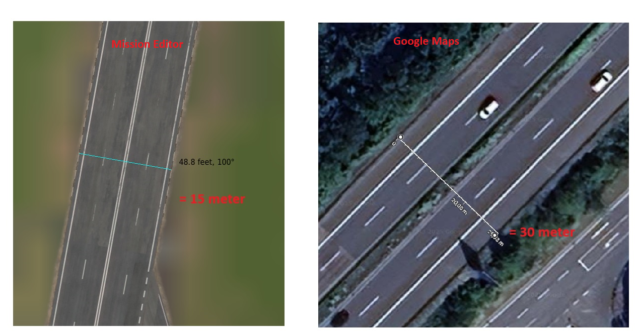
Please enlarge german autobahn in size, to be better recognised for visual navigation. Little research results: Pre 1990 german motorways usual dimensions were between 3,5m-3,75m per lane plus aditional 0,5 meters either side next to it. The Space in between opposing direction lanes was three to four meters in width. Motorways pre 1990 usually had an extra stop lane for broken down vehicles which added another 2meters minimum each side in width.
 7 points
 -
7 points
-
Things are progressing well. Still on internal testing but I can tell you it's working and getting better every day.7 points
-
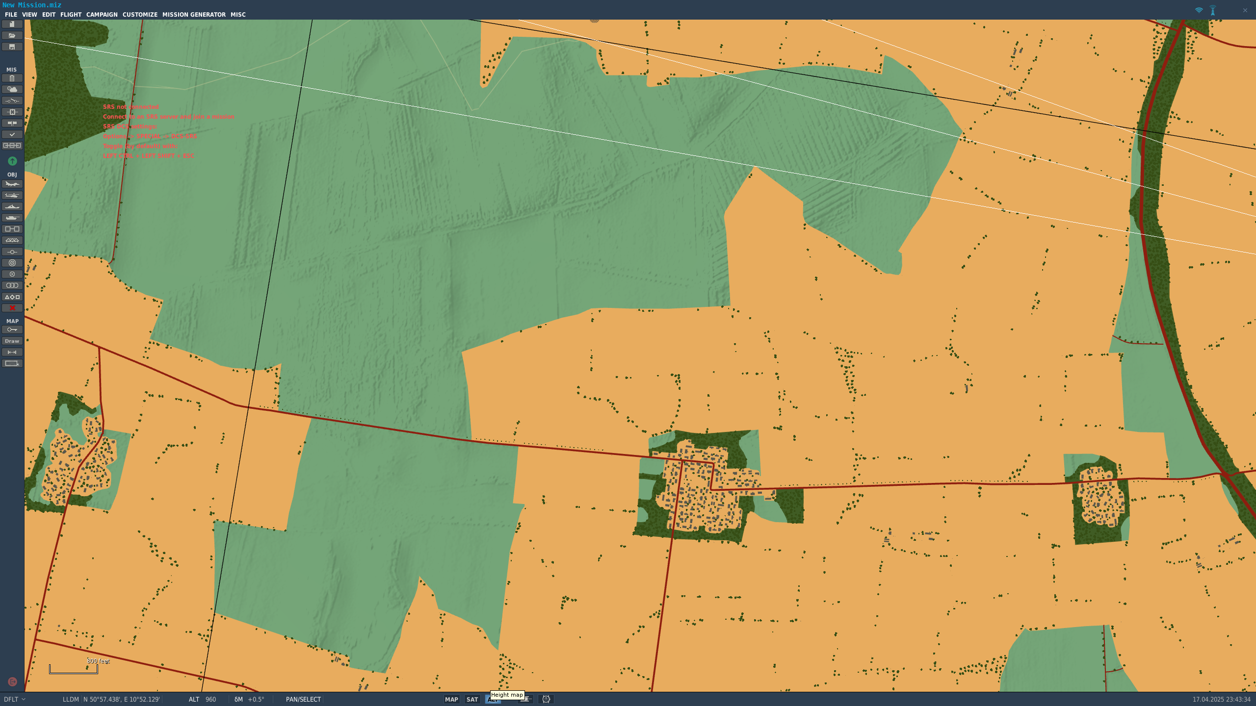
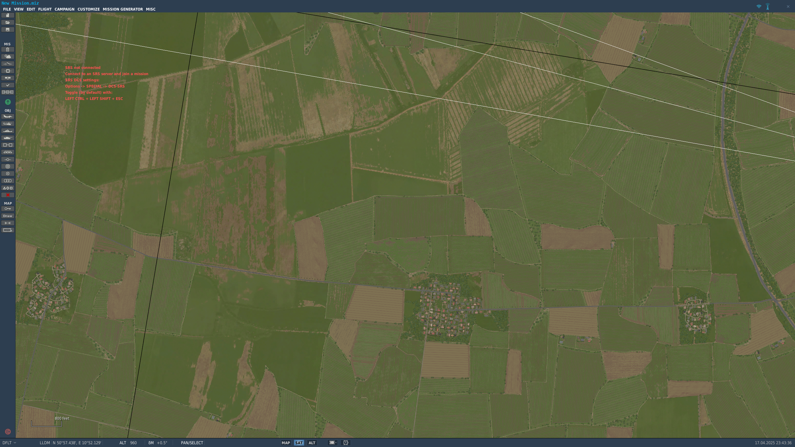
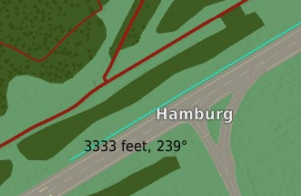
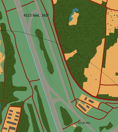
The DCS F10 map colours urban areas yellow. On the Germany map any areas with fields appear to be classified as urban, and therefore get coloured yellow. This makes navigating using the F10 map very very difficult, as it's hard to determine where towns are and therefore use them as landmarks. See the two screenshots - they are taken at the exact same place, just switching between 'alt' and 'sat' modes. nullnull
6 points
-
It's not a show-stopper but an option to not have hot-air balloons flying would be great. I can see the use of 1 or 2 air-race circuits on the map or even harvesters in some fields but I doubt anybody would feel the need to go hot-air ballooning during WW3 Besides; if I see balloons I feel like punching someone in the face. Probably some unresolved issues from my youth6 points
-
Best map by far! 1. Visually stunning! 2. Great performance. 3. The LOD at distance seems better than other maps. 4. Offer almost unlimited scenarios. Bugs 1. One bug though, I can't seem to place A10s on the ramp at Spang AFB, only hot start on the runway. I am sure this will get fixed. A few wish list items. 1. I wish the border line (red line) was more noticeable on the mission editor map. No big deal. 2. I wish the SAM sites pads were marked on the mission editor map. Still like I said, in my opinion the best map by far. Hats off to the team regarding this map, money well spent!6 points
-
Im just confirming with heatblur about jester, and if I need to we can get it added to the logs.6 points
-
Release Version Current version number: DCS 2.9.15.9408 Next planned update: Fix patch 21st April 20256 points
-
Sure, but they camouflaged the chocolate eggs too well so that it took far too long for the hamsters to find them:5 points
-
Whoa, a patch on the 2nd day of Easter. That is a bit above and beyond, we could have waited a couple days5 points
-
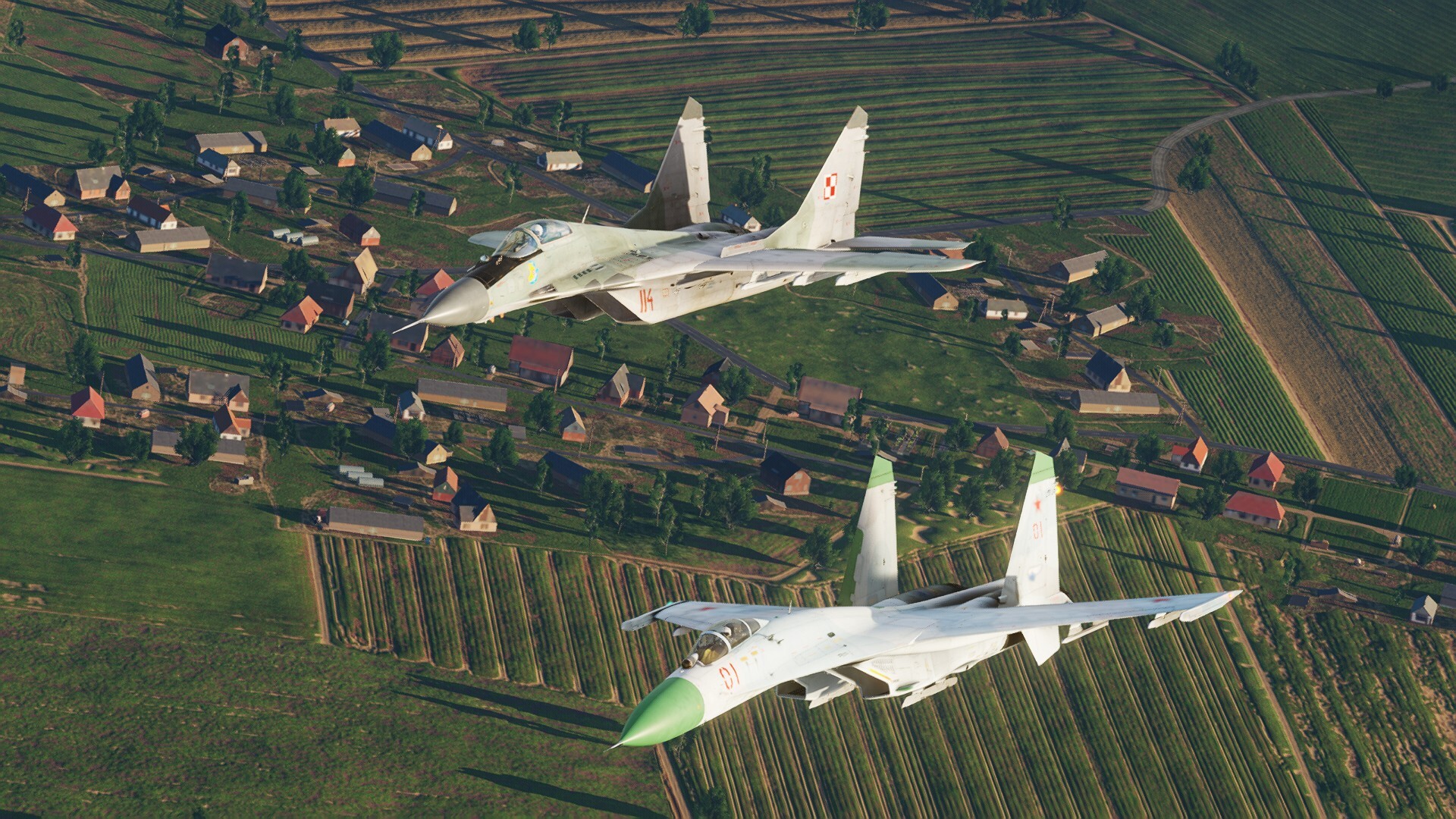
Mig-29 from Polish 1. WPLM stationed in Mińsk Mazowiecki and Russian Su-27 from 159.Gv.IAP stationed in Kluczewo airbase. flying together on the border of GDR and Poland, 1991.
5 points
-
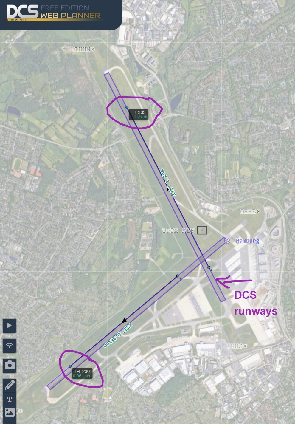
DCS uses Transverse Mercator projection. In the case of CWgermany the central meridian is 21° E The runway locations are correct and match the real world sattelite imagery. I know this, because we export the runway coordinates and render them inside DCS Web Planner (purple rectangles) https://dcs-web-editor.github.io/dcs-web-viewer-deploy/?lat=53.63664895322603&lon=9.98785972595215&zoom=14# What is incorrect, is the TH as well as the MH reading inside DCS and DCS ME. So it appears to be rather a bug with DCS than this particular map.
5 points
-
Both of you guys are confusing things and I wish we could have kept all this out of this thread. VOR are VHF Omnidirectional Range radionavigational aids operating in the VHF band (hence the name) between 108 MHz and 117.95 MHz, historically only used west of the Iron curtain. NDB are Non-Directional Beacons operating in the LF and MF bands, between 190 and 1750 kHz. Its an ancient concept, used by east and west alike. NDBs can be used along airfield approach paths, often co-located to Outer and Middle Marker Beacons (which operate on 75 MHz, transmitting vertically upwards within a limited cone. These approaches may also be supported by an ILS but neither the NDBs nor the Outer/Middle markers are in any way part of ILS itself or "ILS beacons", even while they are apparently named like this inside DCS lua files. ILS is an ICAO standard which during cold war times has been widely implemented in the west (globally today) and at 5 airfields only in East Germany (Leipzig, Erfurt, Dresden, Berlin-Schönefeld and Neuhardenberg). ILS is a combination of Localizer (operating between 108.10 and 111.95 MHz within the VOR frequency range) and Glideslope (operating in the 329-335 MHz range) transmitters. Warsaw pact airfields would instead use a RSBN/PRMG combination, which is incompatible to ICAO-ILS. For Warsaw pact airfields, an array of outer/inner beacons is often provided to guide on approach paths laterally from both approach directions of a runway. These are in fact NDBs. While they can be co-located to additional Marker beacons, they must not be confused with these.5 points
-
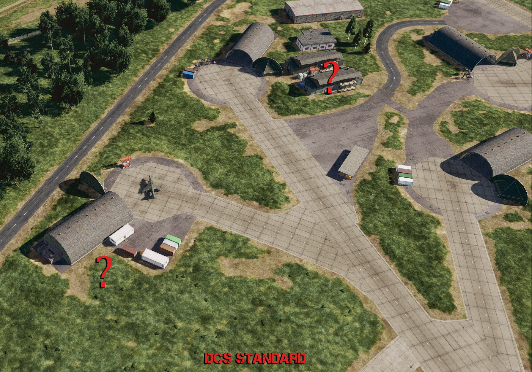
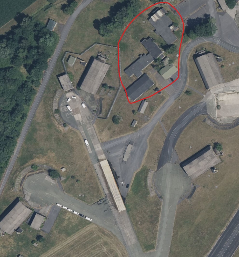
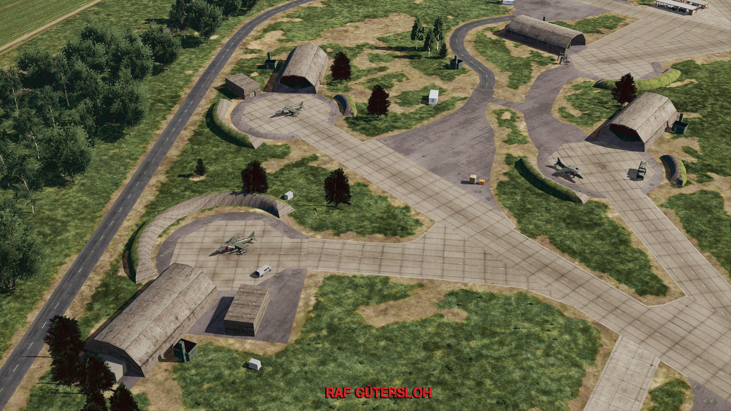
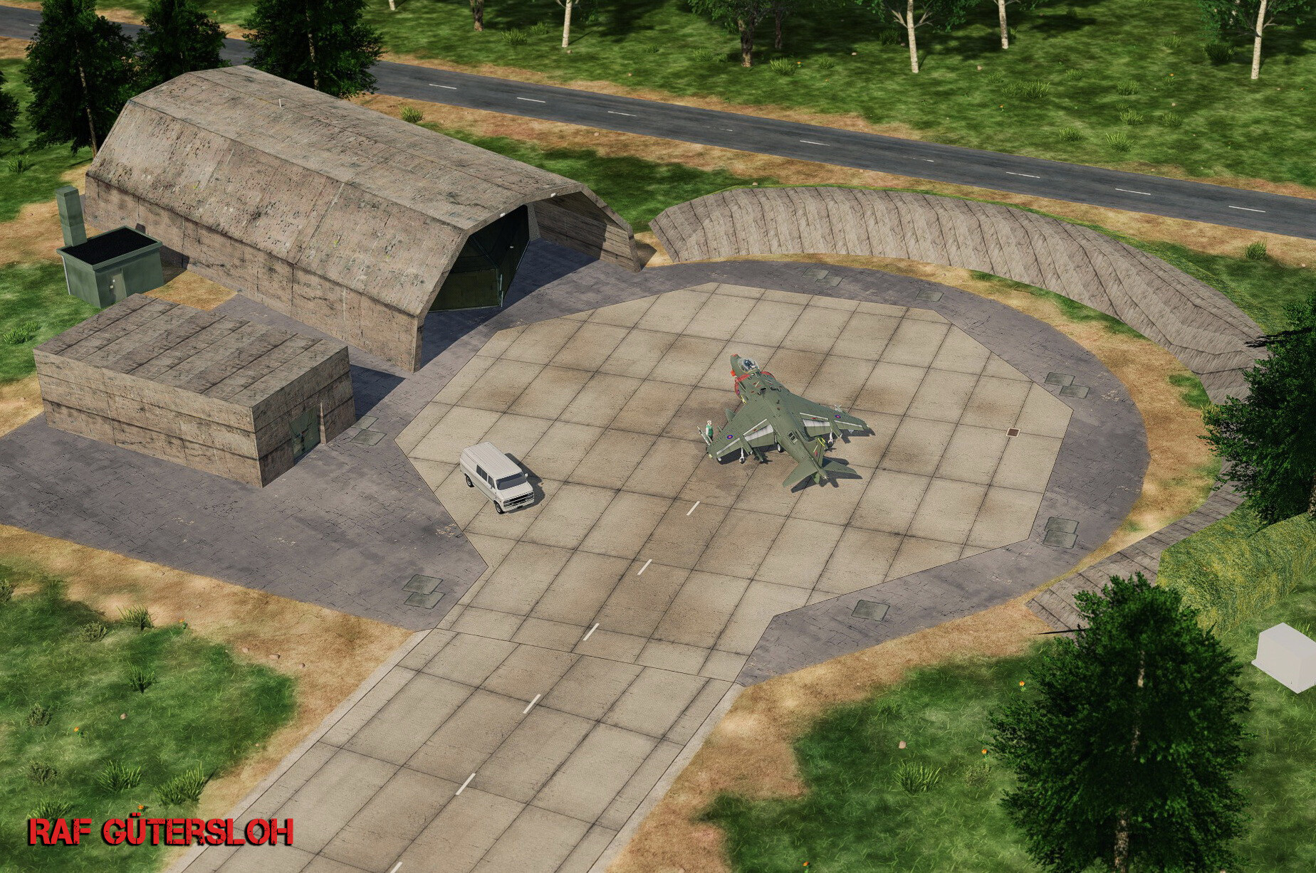
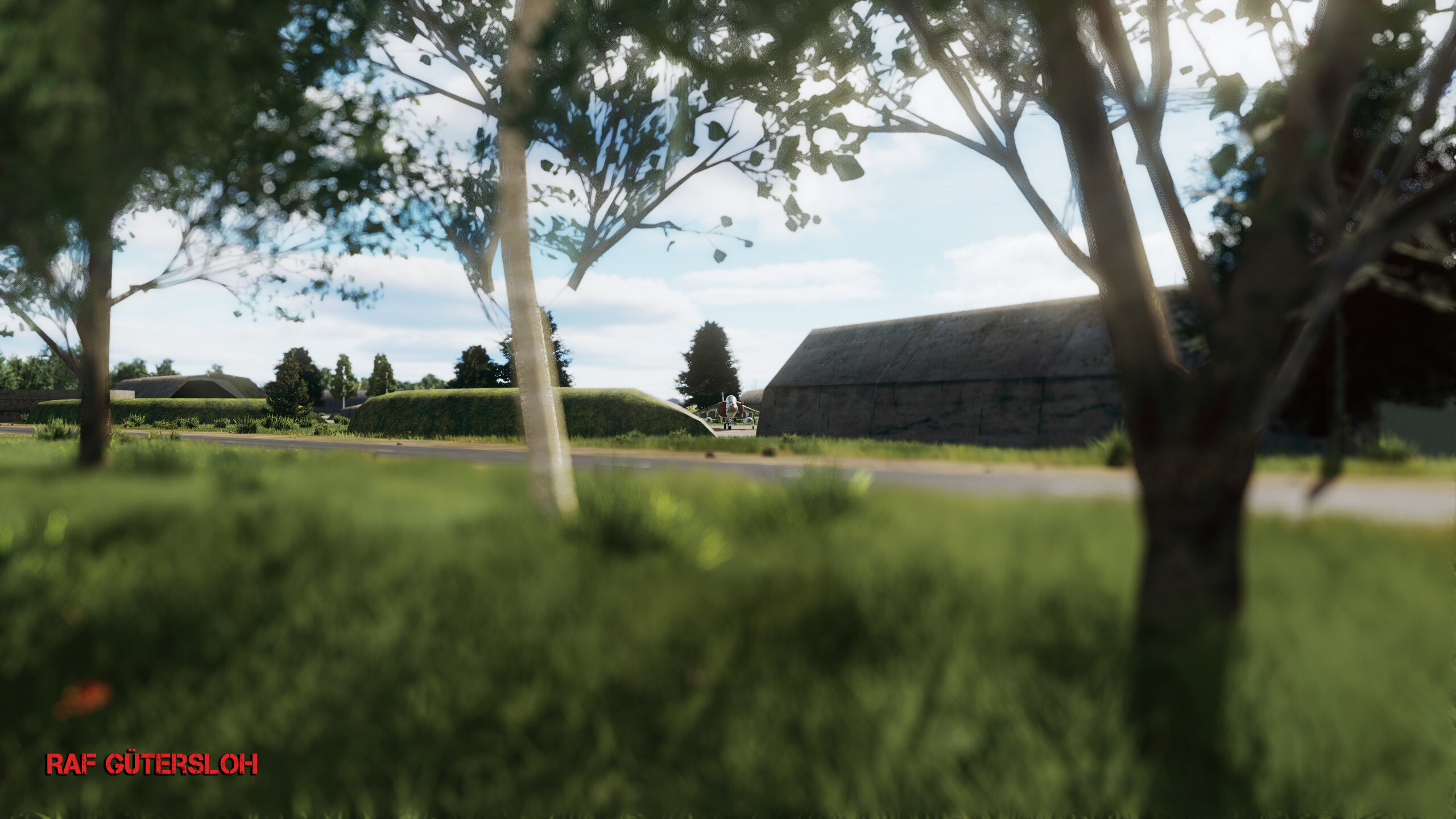
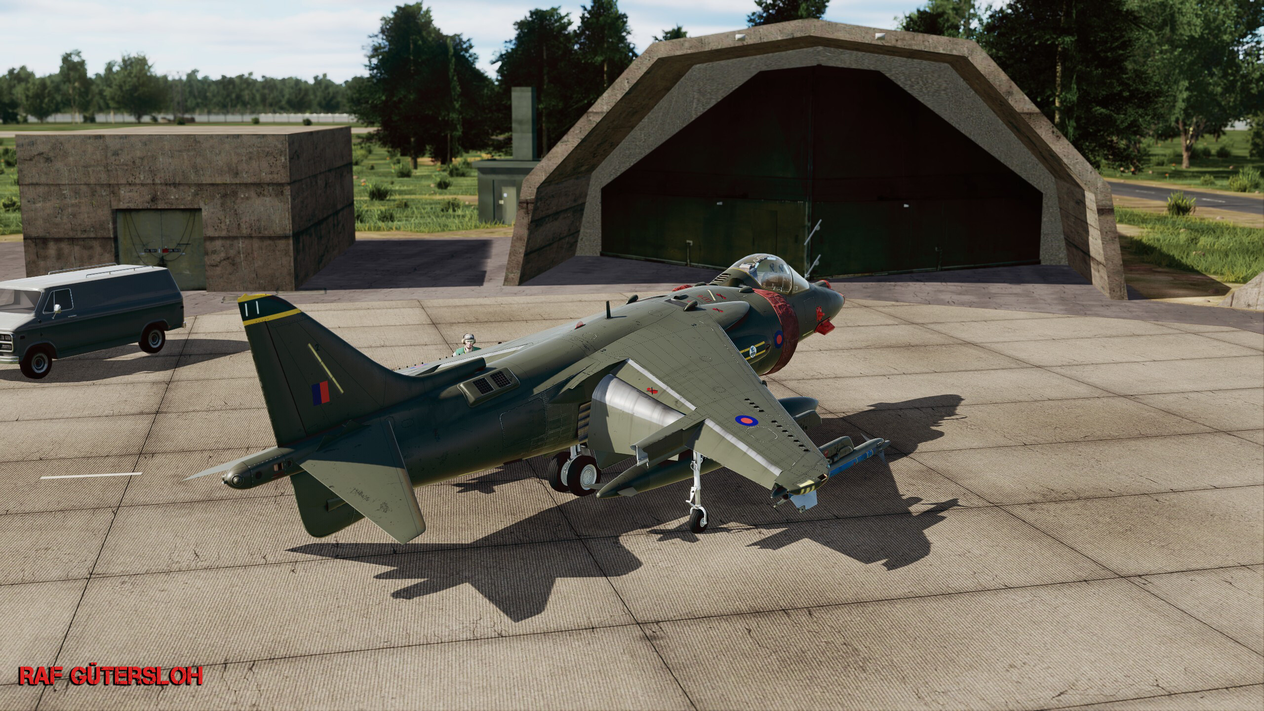
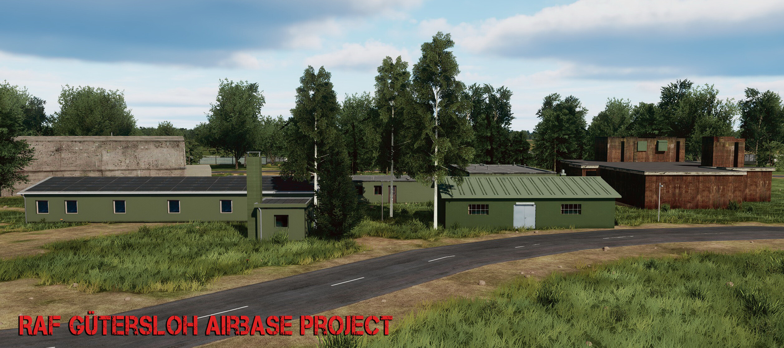
Bought this map 2 days ago. First off, thank you for doing this, UGRA! I know I'm early with this, since a lot will hopefully be added or fixed, but anyway, here we go again... I decided to get back into modding as much as possible. I know I never really finished what I started back then, but I can say I learned a lot. This time it feels different, because it's Germany — I live here on the westide if germany, grew up here, and know many of the bases since I was a little kid in the early '90s. So there's a personal connection to it to some degree. (Even if LA is my second home.) This isn't meant to bash anyone, but I did pay $55 for this map, so yeah — while I don't expect much accurate cities or villages (it's not possible without satellite data or AI generating detailed roadmaps and building placements), I do at least expect the airbases to be accurate. Right now, RAF Gütersloh looks like a civilian airport, with 99% inaccurate buildings. Also, the shelters are wrong — too many colorful buildings and so on. It's fun to have a bike at all the main gates, but I'd prefer accuracy over little details like that. So, I decided to start this project. And yes, it will take time and resources — I'm on my own doing this. More about that later. This is just a start — models are not finished yet, it's all work in progress. The only thing that's finished right now is the shelter concrete texture. Sad thing already: the AI gets scared when you place something "over" their "heads" — jets automatically choose the next available ramp start spot to take off from, even though the shelters don't even have a collision shell yet. Choosing ground start is no option since the Harrier go full speed and just crash somewhere.. very buggy So the idea with Shelters is, to some degree, useless until one of the following happens: - UGRA Media adopts my hardened shelter model, - or they create their own, - or ED tweaks the AI so they're less "scared". (Also hoping the scenery remove object tool gets enhanced too.) enough talk for now... very early stages shots
4 points
-
Noticed when I took off from Ramstein and landed at Hahn, there is way too much brush and bushes in the infield of airports, between runways and taxiways, and alongside runways. Note that this seem to be a problem in other maps as well, but really stands out on NATO airfields (where I was stationed and flew out of at the time portrayed). Airports all have standards for clear areas around runways to keep birds and game away, and to minimize obstructions to vision of airfield signs. So pretty much everything around the runways is cleared and mowed. Having random bushes obscure distance markers is not a good idea... Otherwise...GREAT MAP! Can't wait to drop an LGB into my old office on Ramstein. Vulture4 points
-
First of all: Thaks for this map, I was waiting for. The position acuracy of streets, even in more rural areas is amazing!! I suggest following changes to the Airfield: Spawn Positions 1-20 ( for fixed wing aircraft) need to be moved outside of hangars, as wings collide with structure during taxi. Bückeburg was used for Helicopters and light aircraft only. null remove the countless light poles and little shelters from tha apron for safety and maybe game performance reasons. maybe spawn position numbering needs rearrangement null
4 points
-
We are working on it now. There will also be changes to the external model to support new EFM functionality.4 points
-
Hello Ugra team, @MAESTR0 thank You for Your amazing map. She has so much detail, that I would rather play FPS than planes. As from Czech Republic We are looking forward for Phase 3. From FAQ, We are missing in list a military airfield Žatec (1945-2000). A main base of 11th Fighter Regiment from 1954 to 1992. It was the base where the Tiger Squadron was formed . Zatec was very important base in CSR and for our aviation in general. We would be very happy to help You with data, maps, charts and photos. It is possible to make airfield after its modernization after 1982. We are with close contact of museum about this airfield “Korea-Merkur” and also contact with former commander of this base. You can contact me by PM. For beginning::: Korea Merkur Museum: https://www.lmkm.cz/historie-letiste.html Map setting 2001-2003, before demolition https://mapy.cz/letecka?profil&x=13.5921400&y=50.3699611&z=15 Archive map 2003, https://ags.cuzk.cz/archiv/ null Youtube videos with subtitles:
4 points
-
Nein, i.d.R. sind markante Points Of Interest (Gebäude, Denkmäler, etc.) an den richtigen Stellen, dazu wird ein, ungefähres Strassennetz erzeugt und die Bereiche innerhalb Städten mit generierten Gebäuden gefüllt. Das Ambiente einer "Altstadt" oder einer "Plattenbausiedlung", aber auch einer ländlichen Siedlungen mit Lehmbauten und Bewässerungsgräben in Afghanistan wird glaubwürdig und ich finde, für eine Flugsimulation, sehr detailliert abgebildet. Es ist immer eine Balance aus Performance, visuellen Details und Speicherbedarf. Gebäude in DCS sind fast alle zerstörbar, müssen also in einer Tabelle gespeichert werden, auf Kollision mit Waffen oder Flugobjekten geprüft und entsprechend als zerstört "geflagt" werden. Das braucht Rechenleistung und Speicher. Deutschland zählt zu den dicht besiedelten Ländern auf dem Planeten und mit dem Wissen, um die Performance, bin ich von der Map und der Menge an Gebäuden und Details, echt angetan! Das ist bereits jetzt verdammt gut optimiert, finde ich. Nicht zu vergessen, irgendwer muss das auch alles erstellen und platzieren. Klar, wären akkurate Gebäude, überall, mit absolut realem Straßennetz, bis runter auf die Gassen in den Altstädten, der absolute Traum, aber die Zeit und der Aufwand, stehen dazu in keinem Verhältnis. Selbst der FS2024 nutzt aus gutem Grund "procedural Generation" für die Gebäude und Stadtteile (oder Photogrammetrie, was aber nur ab 6.000ft Flughöhe erträglich aussieht). Mein Eindruck ist bisher sehr positiv. Man kann Landschaft, Orte, Strassen und POIs die bereits drin sind gut erkennen und danach navigieren, auch wenn manches (noch) fragwürdig ist - eine kleine militärische Anlage mit Heliport, mitten in der Eilenriede in Hannover, wüsste ich jetzt nicht - aber dafür passt die A2, die Heide inkl. Truppenübungsplatz Bergen-Hohne und Lager Oerbke ist, wo es sein sollte, auch wenn nicht jede Barracke/ jedes Kompaniegebäude abgebildet ist. Der Harz ist großartig, auch Fulda erkennt man, mit dem Dom, Bahnhof und Aueweiher, Petersberg und Stadion. Dafür sind Schlitz und Bad Salzschlirf eher generisch, aber da wo sie hingehören. Ich habe noch nicht alles erkundet, was ich von Deutschland kenne, aber mein persönliches Fazit: Die Map ist für einen Early Access fantastisch! Das Look and feel ist toll und man findet sich gut zurecht und kann Städte, Ortschaften und Wegenetz gut identifizieren. Ist jetzt alles perfekt? Nein, natürlich nicht, es gibt die üblichen, notwendigen Kompromisse, auch fehlt sicher das ein oder andere markante Gebäude und an der einen oder anderen Stelle ist der ein oder andere Heißluftballon oder mittelalterliche Wehrturm zuviel. Aber hey, das ist Early Access, gerade man ein paar Tage raus und wir haben noch Phase 2 und 3 vor uns nachdem diese erste Phase abgeschlossen ist. Nach der Erfahrung mit Normandie und Syria ist Ugra-Media auch sehr offen für konstruktive Kritik und ehrliches Feedback, auch wenn es nicht immer gleich im nächsten update passiert (an diser Stelle nochmal danke für Afrin ). Ich freue mich auf jeden Fall, daß wir diese Map in DCS haben. Genau wie über Iraq und Afghanistan, Kola, Sinai, Syria, South Atlantic, Normandy, Channel, Marianas und Caucasus. Auch wenn ich gerade nicht weiß, wo ich zuerst Missionen bauen soll...4 points
-
Ich find die Karte toll. Natürlich ist sie nicht fotorealistisch, aber das konnte bei diesen Dimensionen ja nicht wirklich jemand erwarten. Ich zumindest nicht. Der Gesamteindruck ist jedenfalls stimmig und die Details großartig. Natürlich ist die Meckerei in Deutschland größer, schließlich wohnen wir hier und kennen uns aus. Aber der Rest der Welt wird die Fehler nicht bemerken.4 points
-
I totally agree. In my case, I have all the modules and maps, and at least half of the campaigns. Updating the game is becoming increasingly complicated. I had to uninstall the War Birds DLC and the WWII resource pack, along with the maps corresponding to that era. Otherwise, all those libraries would be there, and if I were lucky enough to use two or three in particular from each module, I'd have hundreds of gigabytes to install other maps. IT SHOULD BE OPTIONAL! Some way to select which library you want, since installing and uninstalling modules and maps is cumbersome, inconvenient, and a total waste of time! You have to plan ahead and install or uninstall a map; it makes no sense at all. You can use the new start interface to select whether you want the skins from each DLC. It would help a lot of people!4 points
-
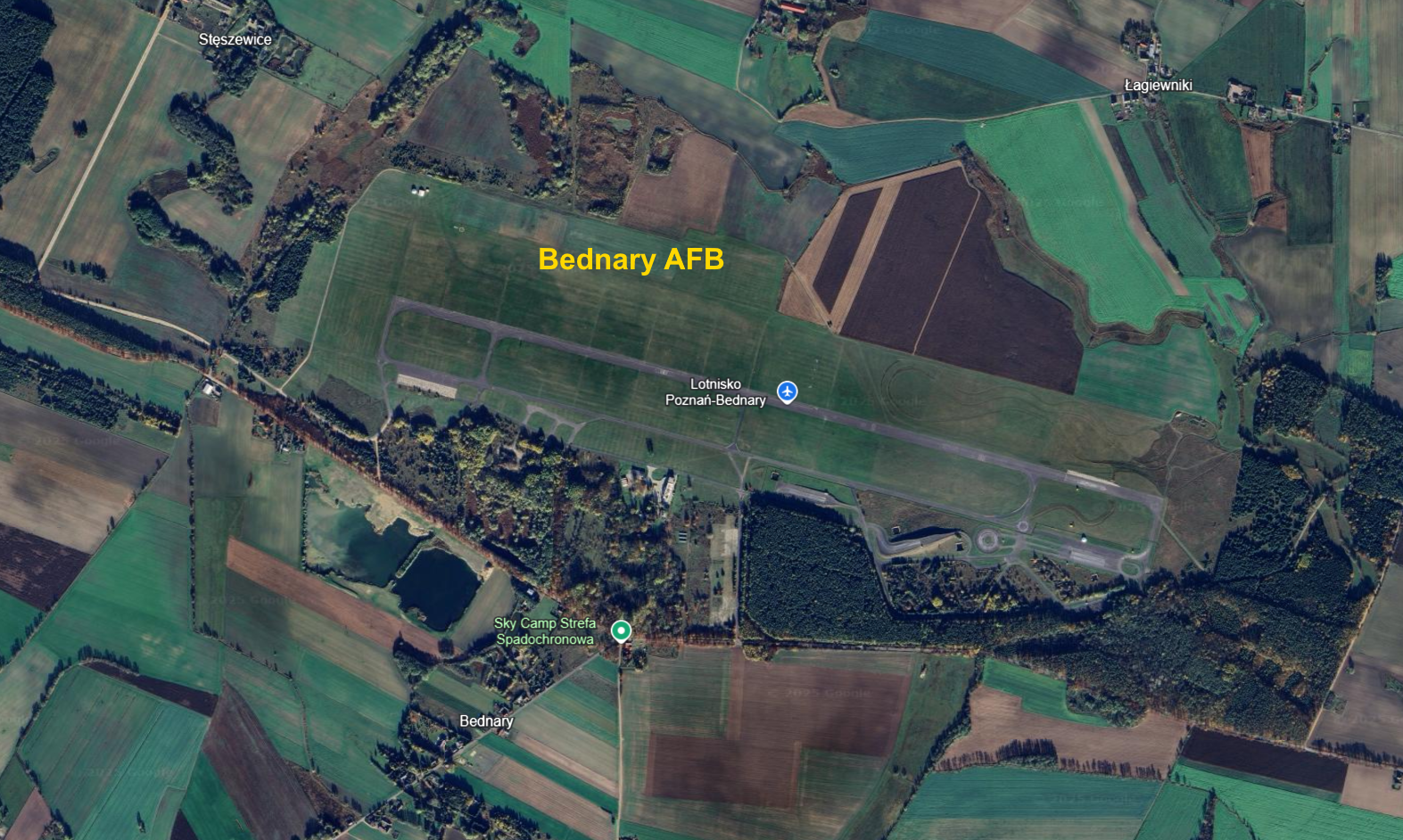
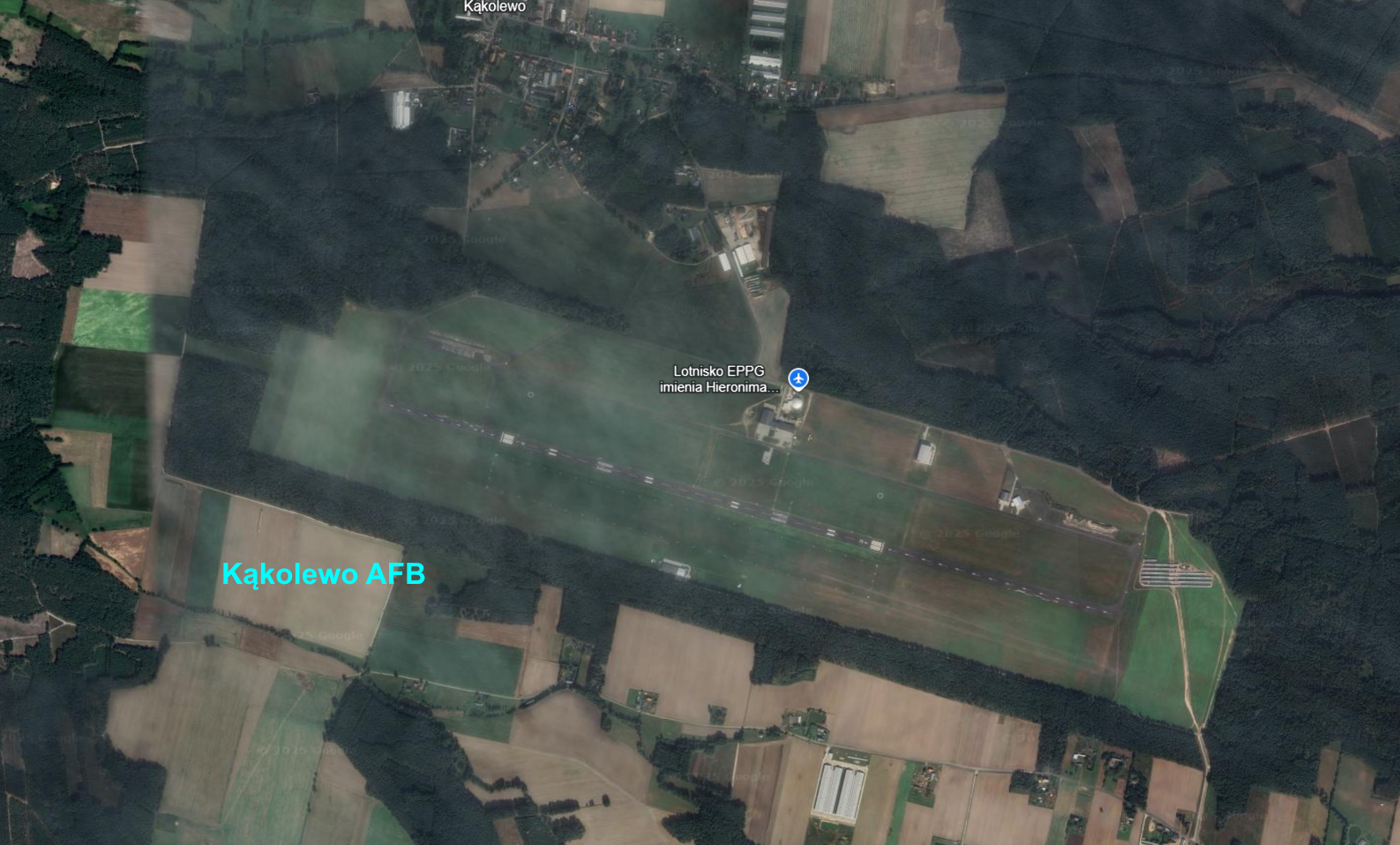
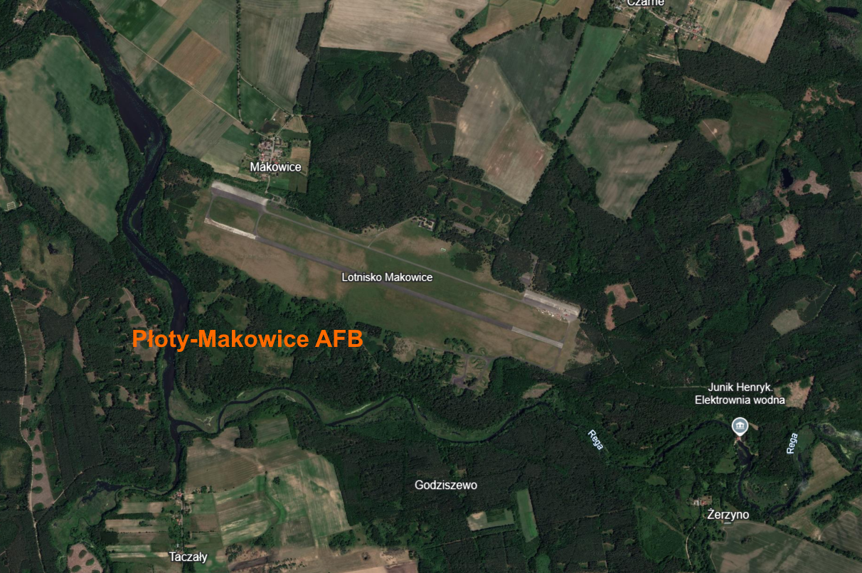
Polish Air Force Alternative Airports - Southwest - Kąkolewo AFB - alternate airport for the 62.PLM from Poznań-Krzesiny AFB and 45.PLMB from Babimost AFB - Bednary AFB - alternate airport for the 62.PLM from Poznań-Krzesiny AFB and 7.PLBR from Powidz AFB (In the war, the planes and the regiment could relocate to one of the alternate airports) Polish alternate airports were almost the same, so you could copy Śniatowo airport and paste it in place of Bednary AFB, Kąkolewo AFB and other alternate airports...
4 points
-
UPDATE v2.32 Smaller update but I feel it was long needed - bitching Betty being angry about AoA all the time. Now you will hear her only if critical AoA was exceeded. Also SFM drag parameters were adjusted.4 points
-
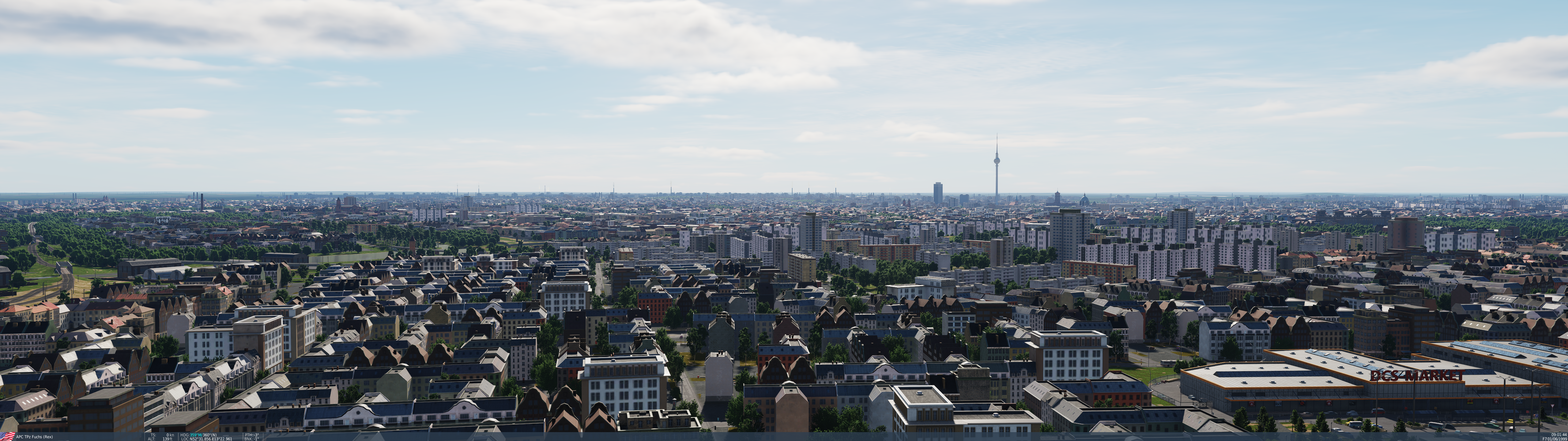
Wow, really good job. Just outstanding! I thought Normandy 2.0 was awesome, and it is, but Ugra-Media may have outdone themselves with Germany. The detail is top-notch, I'm finding all kinds of interesting things in Berlin. It just looks fantastic from every angle. Really nice job! 10/10 My screenshot is poorly-composed and doesn't do it justice, but this map is a must-own IMHO.
4 points
-
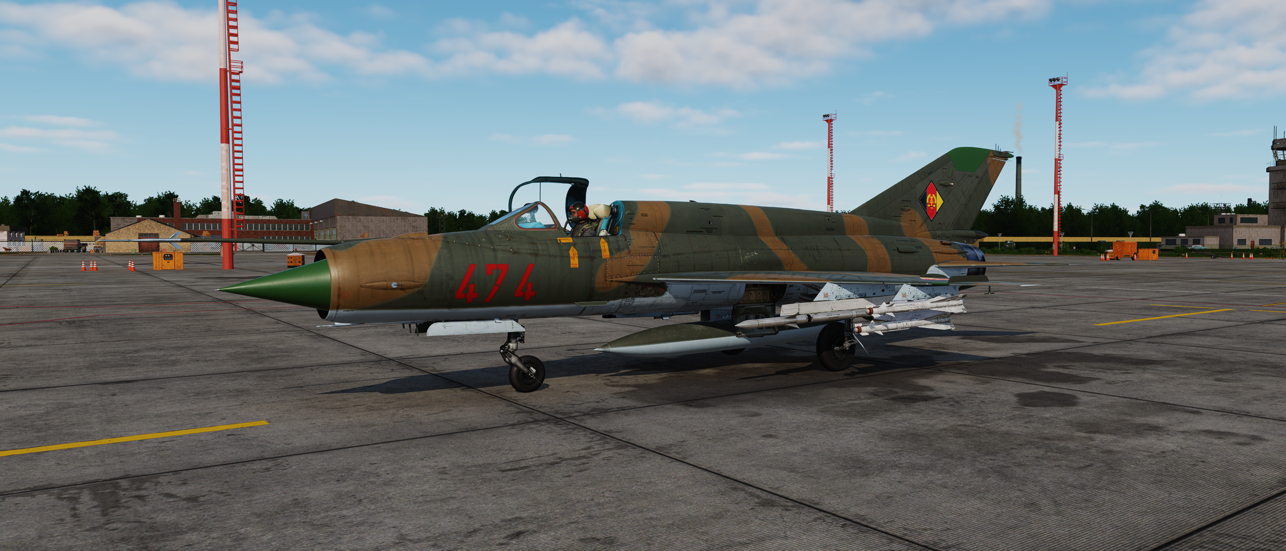
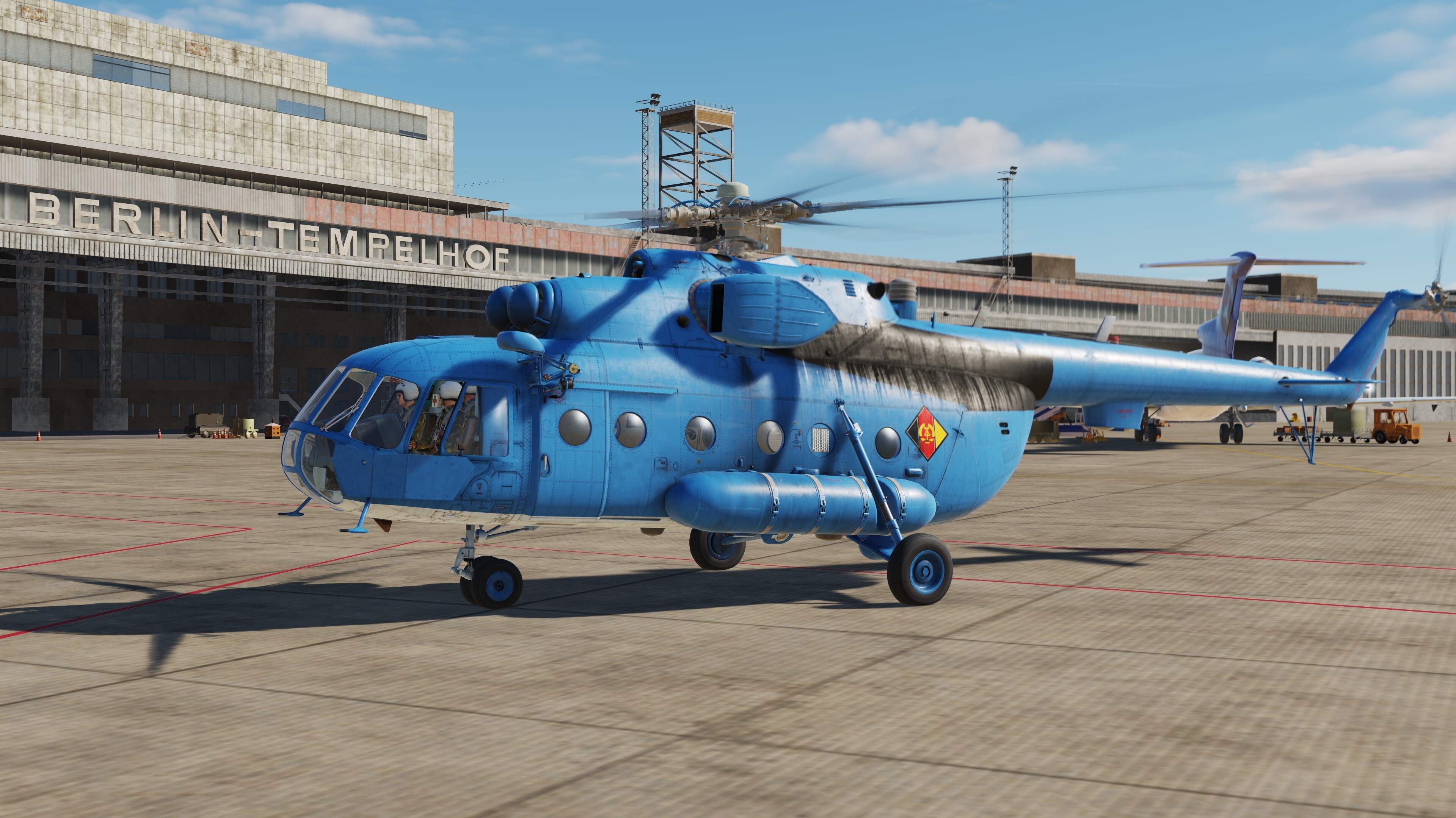
Not sure where the DDR based their Mig-21s so I parked myself at Schönefeld.
4 points
-
Now that the Germany map is out, I think a lot of the planes, both AI and player based, especially eastern bloc should receive East German skins? An-26 Su-17 Mig-29G3 points
-
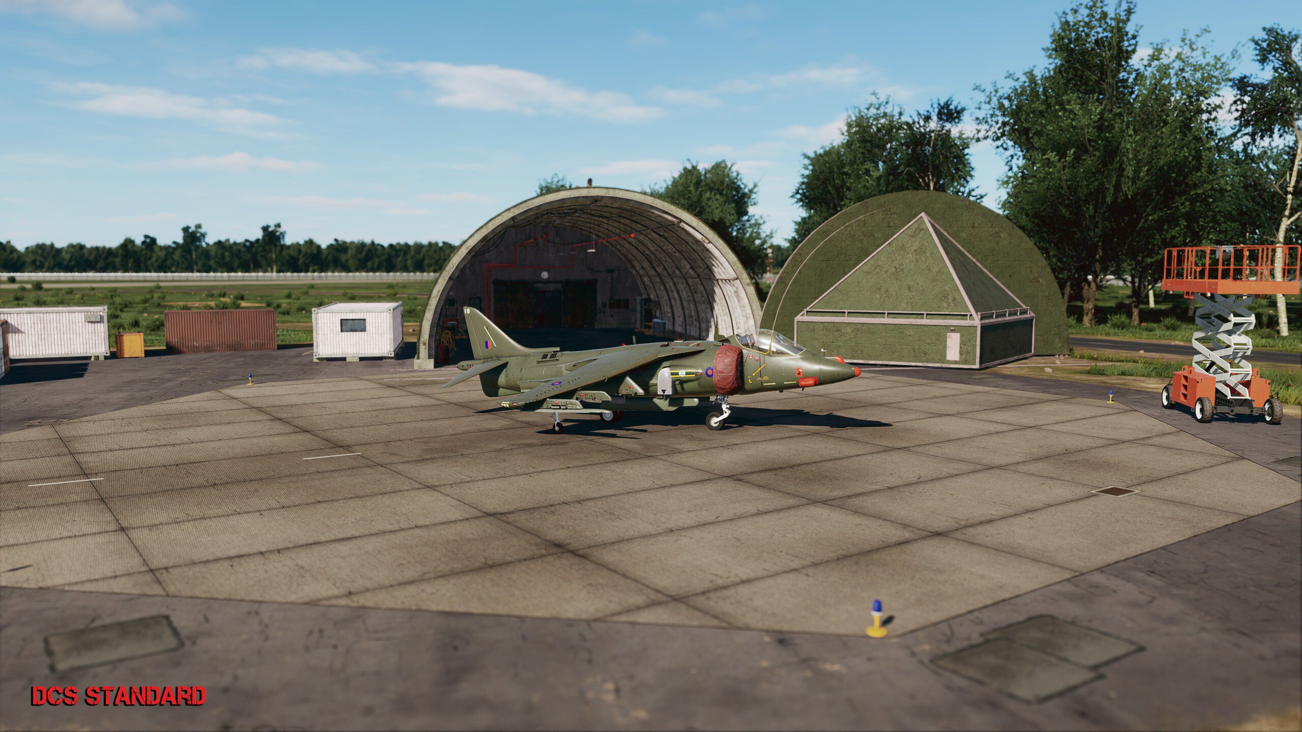
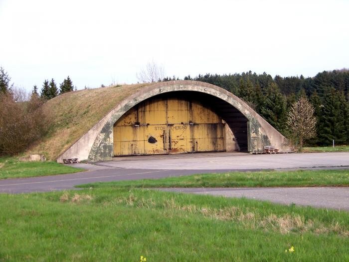
Dear Ugra Team ( @MAESTR0), thank you for this incredible map! I’m just curious if there are any plans to change the shelters on the west German side and make them more realistic?! In Büchel the form is almost correct, a bit to round-ish and the 4 doors in the front are missing as well as a bit to small, as a Tornado wouldn’t fit in there with its wings in fully forward position what they usually did during their after start checks. At Pferdsfeld you have placed the shelters like they’ve used in the east! It would be much appreciated if you could change these to the western style. Attached you’ll find a picture of a Shelter from Pferdsfeld Airbase. Hope to hear from you or get any feedback if you’re planning to change the mentioned items. cheers
3 points
-
57 NDBs across the map have their frequencies in thousands of kHz, so they end up as MHz and are unusable. This is easily noticeable on the mission editor map. They show correct ingame on F10 map, yet you can't receive these when tuned to the regular kHz number. Affected NDBs: West-Germany - Bremen BW and BMN - Hamburg FU - Hehlingen HLI - Braunschweig BRU - Fritzlar FTZ - Fulda FDA - Hahn HAH - Schweinfurt SCF - Giebelstadt GBL East-Germany - Leipzig-Halle SK, S, M and MA - Leipzig-Mockau G - Dessau WN and W - Cochstedt SL and S - Zerbst ZB, Z, K and KJ - Altes Lager LG, L, B, BM - Stendal U and UK - Neuruppin GK, G, W and WD - Finow RG, R, O and OM - Parchim AS, A, U and UU - Neubrandenburg T, T, D and DT - Tutow Y and YC - Laage RL, R, L and RL - Peenemünde EN, E, N and NE Berlin - Tempelhof DBR and DIP all these 57 NDBs require to have their frequencies corrected by division by 1000.3 points
-
The latest update have catastrofic dowload speed. Can't download it now, because of that.3 points
-
Tbh I think thats a big one. Ive driven through Syria with a Land Rover 101 while waiting for Germany (can recommend, thing is a rocket in DCS) and while eg Damascus is impressive form above, it doesnt really look like a real city. Germany a huuuuuuuge improvement on making a City actually look city like. Im honestly quite impressed they even got most of the streets in my small 100k people home town right (its like the 100th biggest city in DCS). The small streets dont match and some areas defintely look more 40s than 80s, but even then I can clearly recognize the layout. And mind, thats while even first phase Germany might already be as big or bigger than Syria, with much more densely populated, detailed land area. I think we should have high expectations for a $60-80 map and good criticism is always worthwhile, but its also pretty damn cool for a DCS map.3 points
-
Those are valid criticisms, but tbh, it sounds like you got unrealistic expectations about the map. This is probably the most detailed and accurate DCS map, right? And one with the largest detail area to beat already in phase 1. More than this is probably out of the scope of DCS for the foreseeable future, people already complain about the level of memory used or performance (which isnt even bad considering detail+scale). I certainly wouldnt complain about improvements like a bit more fitting architecture, some 80s towns kinda look like 50s towns, or even higher accuracy, but DCS cant be MSFS2024. And even that game has shortcomings that would be unacceptable in DCS.3 points
-
All right, he aligned the INS as before the infamous patch, ready to taxi!3 points
-
Actually it depends on user preference, as SP has a lot to offer, for example: I can fly in whatever Map I want, with whatever aircraft I want (even User Mod aircraft), at whatever local date and time I'm free to escape real life. And I can make my own missions, employing whatever User assets strike my fancy. For me, the only real disadvantage is that the AI opponent is not as skilled as a real human ... but it is still good enough to satisfy my main interest: study and understand my current aircraft of choice. However I understand that other users feel more attracted to the competitive side of DCS, and that's OK.3 points
-
"Na, wat ham se denn jesacht?" "Dass es hier kein Begrüßungsgeld gibt. Wir hätten vorhin an der Ampel links abbiegen müssen, wie ich dir gesagt hatte..."
3 points
-
this should be a must, i'm already using 1TB dedicated to DCS and this kind of monopolization of disk space is a bad word in gaming industry can you link that post in case it also helps?3 points
-
OPEN STRESS TEST CLOSED - MISSION IS AVAILABLE AS DOWNLOAD Thank you all for helping me making this a better mission. It's now available from ED's User Files3 points
-
DCS: F-5E Remastered in colors of F-5E Tigre III of Chilean Air Force (FACH) 1.0 Here's my entry. For now, I'm only sharing the DDS files for download. If you can send me FTP access privately, I can upload the layered Photoshop files, since they weigh around 15GB. DOWNLOAD3 points
-
Took the Mi-8 from one of the easter heliports in Berlin around the city. Awesome. around Rotes Rathaus Sneaking around Palast der Republik Unter den Linden (zoomed in to the trees, no Linden tree, literally unplayable *lol* joking) Siegessäule Landing at Berlin Schönefeld.3 points
-
There is significant smoke ingame since launch already for cartridge start. Not as heavy as in the video but that is due ti engine limitations. The graphic effect glutches out heavily in DCS if yiu try to reproduce the look of the IRL footage, it looks extremely silly. But again, there is plenty of smoke already ingame. The rest of what you said is partially modeled already as well and more is planned for later.3 points
-
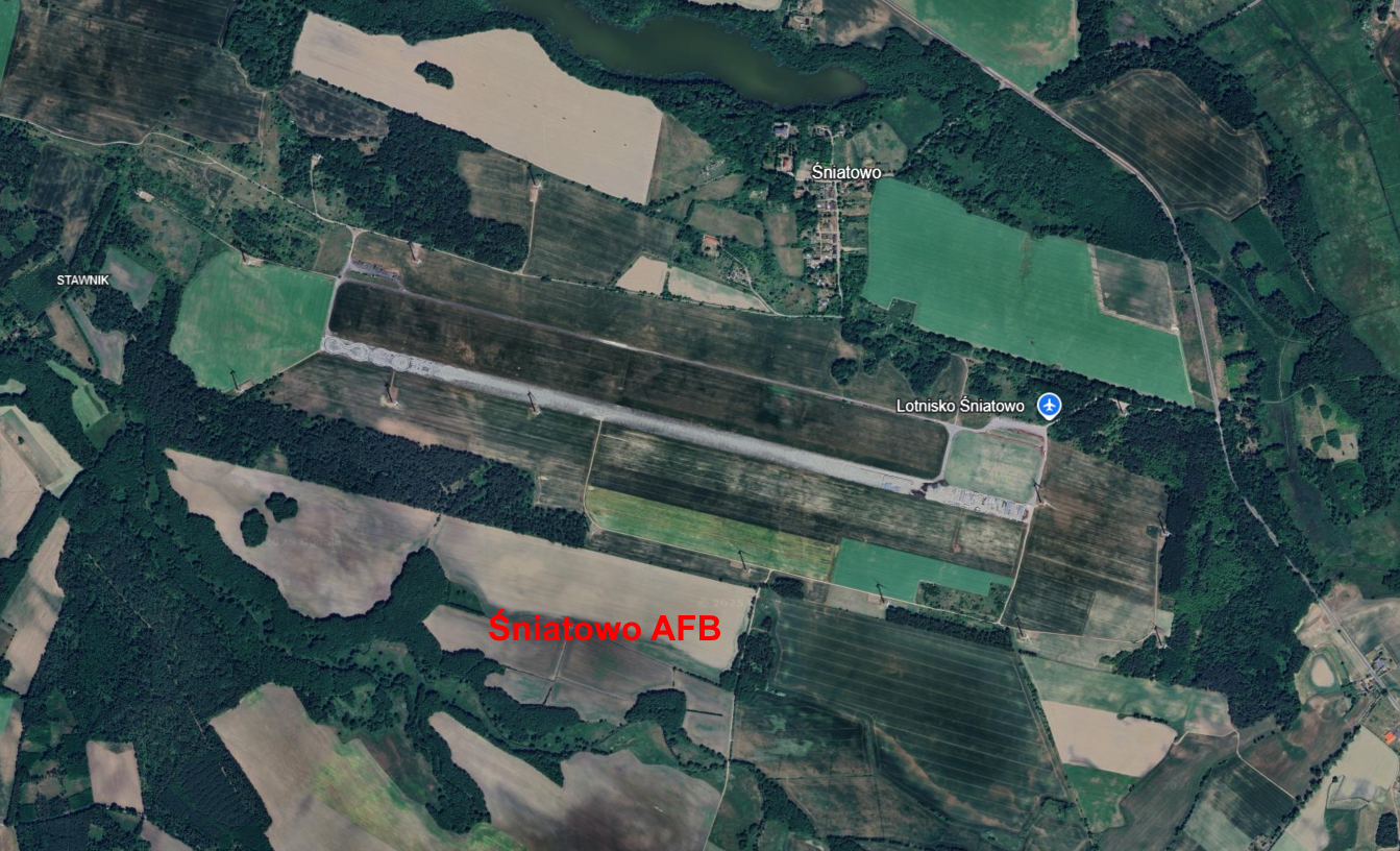
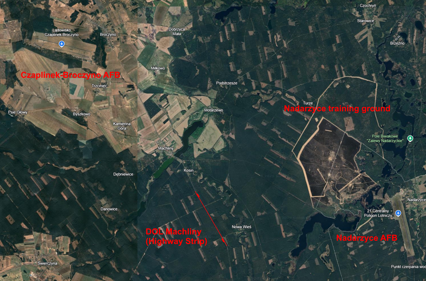
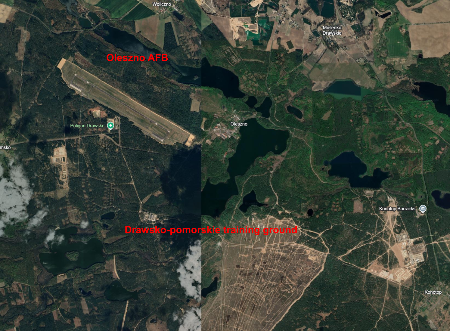
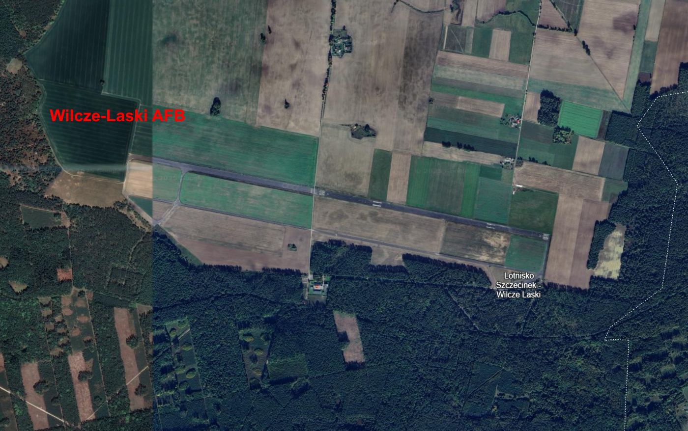
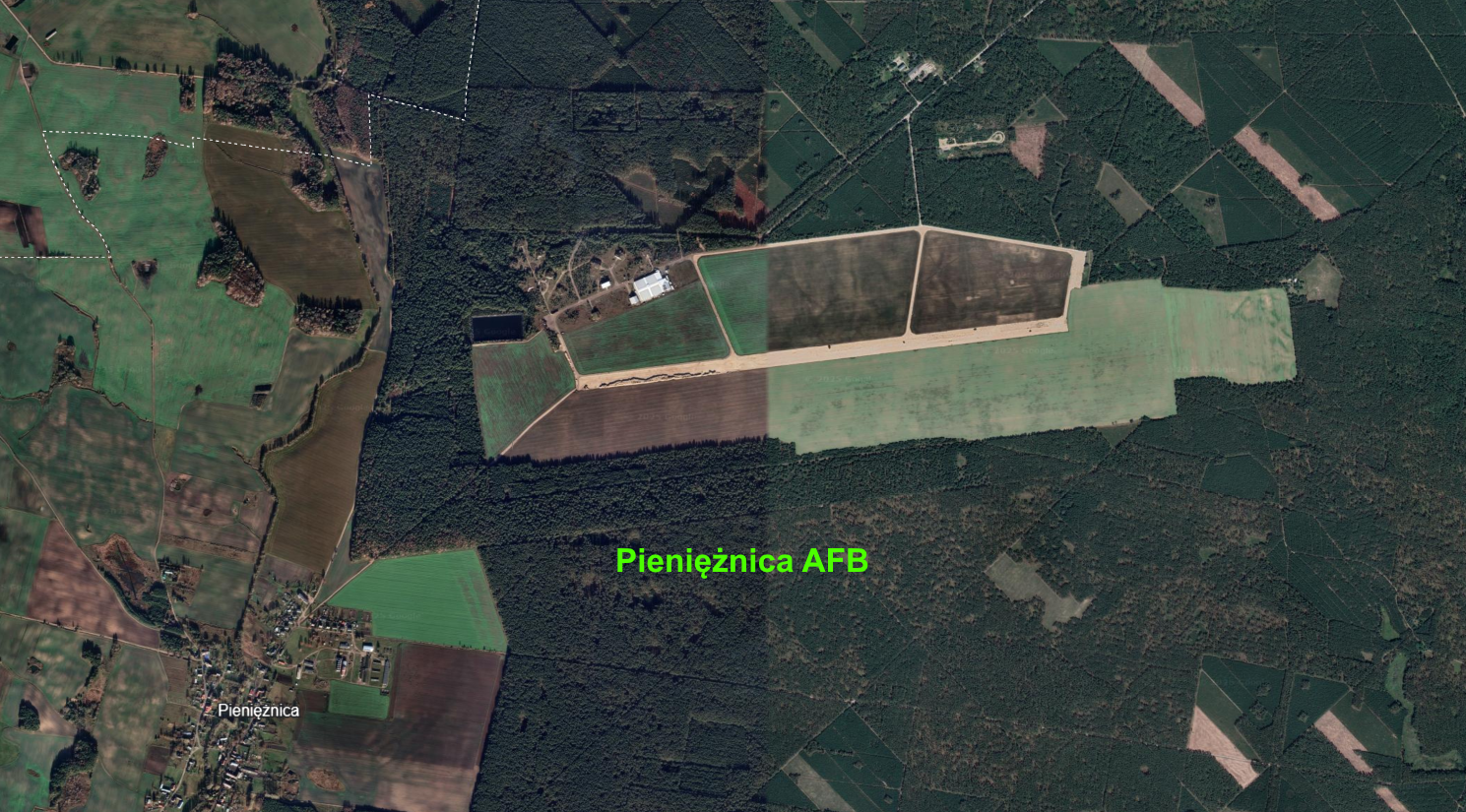
Polish Air Force Alternate Airports - Northwest - Płoty-Makowice AFB - alternate airfield for 40.PLMB from Świdwin AFB - Śniatowo AFB - alternate airport for the 2.PLM from Goleniów AFB and for Soviet AirForce (the airport will be added in phase 3) - Czaplinek-Broczyno AFB - alternate airport for 40.PLMB from Świdwin and 8.PLMB from Mirosławiec - Nadarzyce AFB - alternate airport for the 8.PLMB from Mirosławiec and the 6.PLMB from Piła. The airport is still used by the Polish Army - Oleszno AFB - an airport for helicopters and transport planes at the Drawsko Pomorskie training ground. The airport is still used by the Polish Army - Wilcze Laski AFB - alternate airport for the 9.PLM from Debrzno AFB, 40.PLMB from Świdwin AFB and 6.PLMB from Piła AFB - Pieniężnica AFB - alternate airport for the 28.PLM from Słupsk-Redzikowo AFB (In the war, the planes and the regiment could relocate to one of the alternate airports) Polish alternate airports were almost the same, so you could copy Śniatowo airport and paste it in place of Oleszno AFB, Płoty-Makowice AFB and other alternate airports...
3 points
-
3 points
-
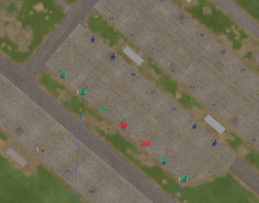
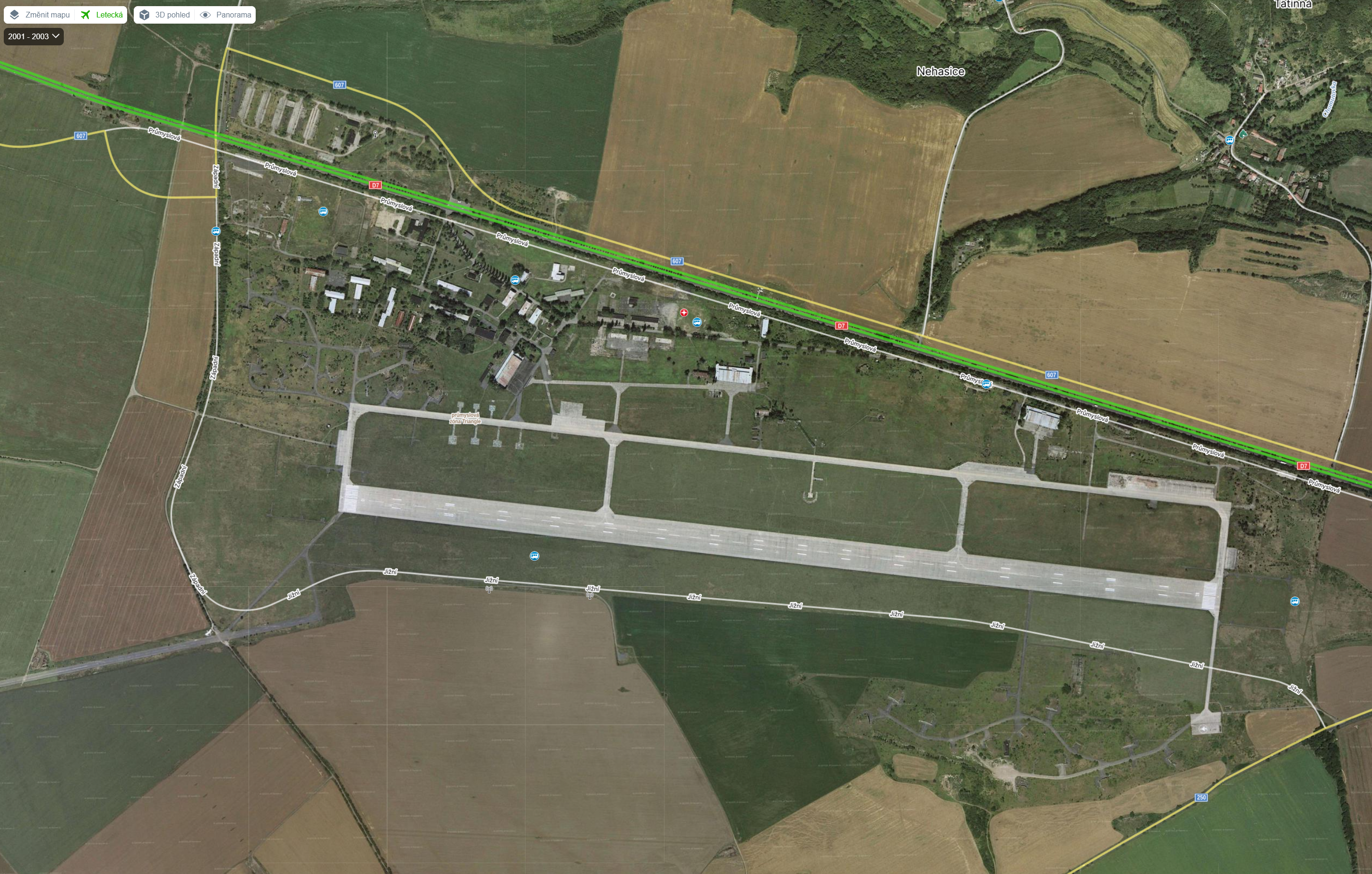
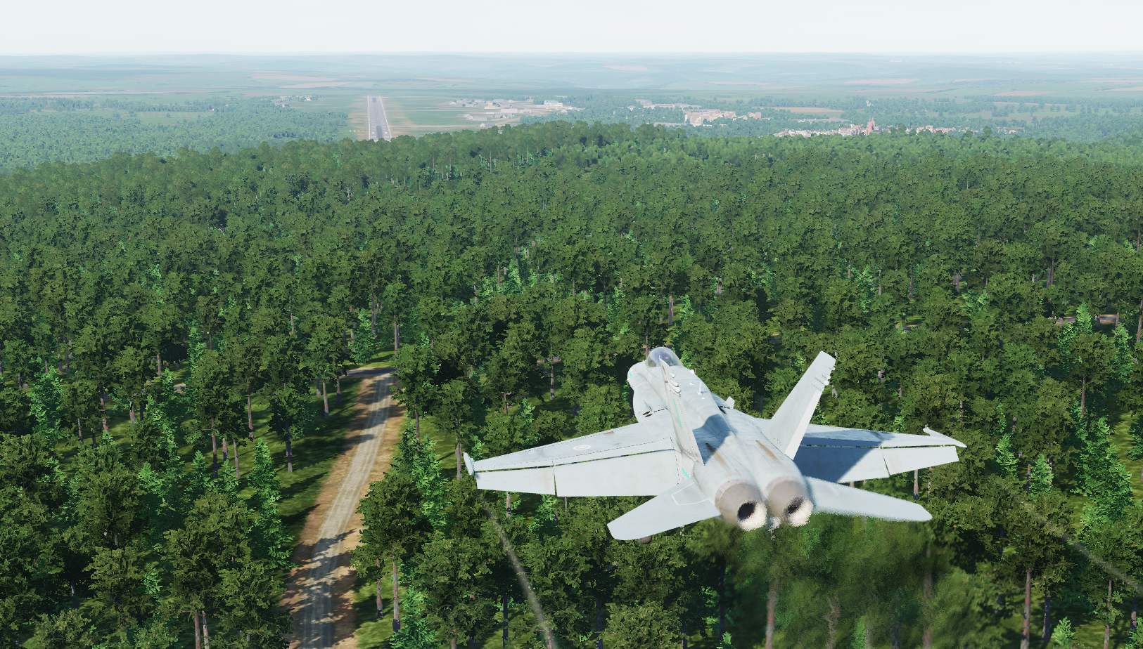
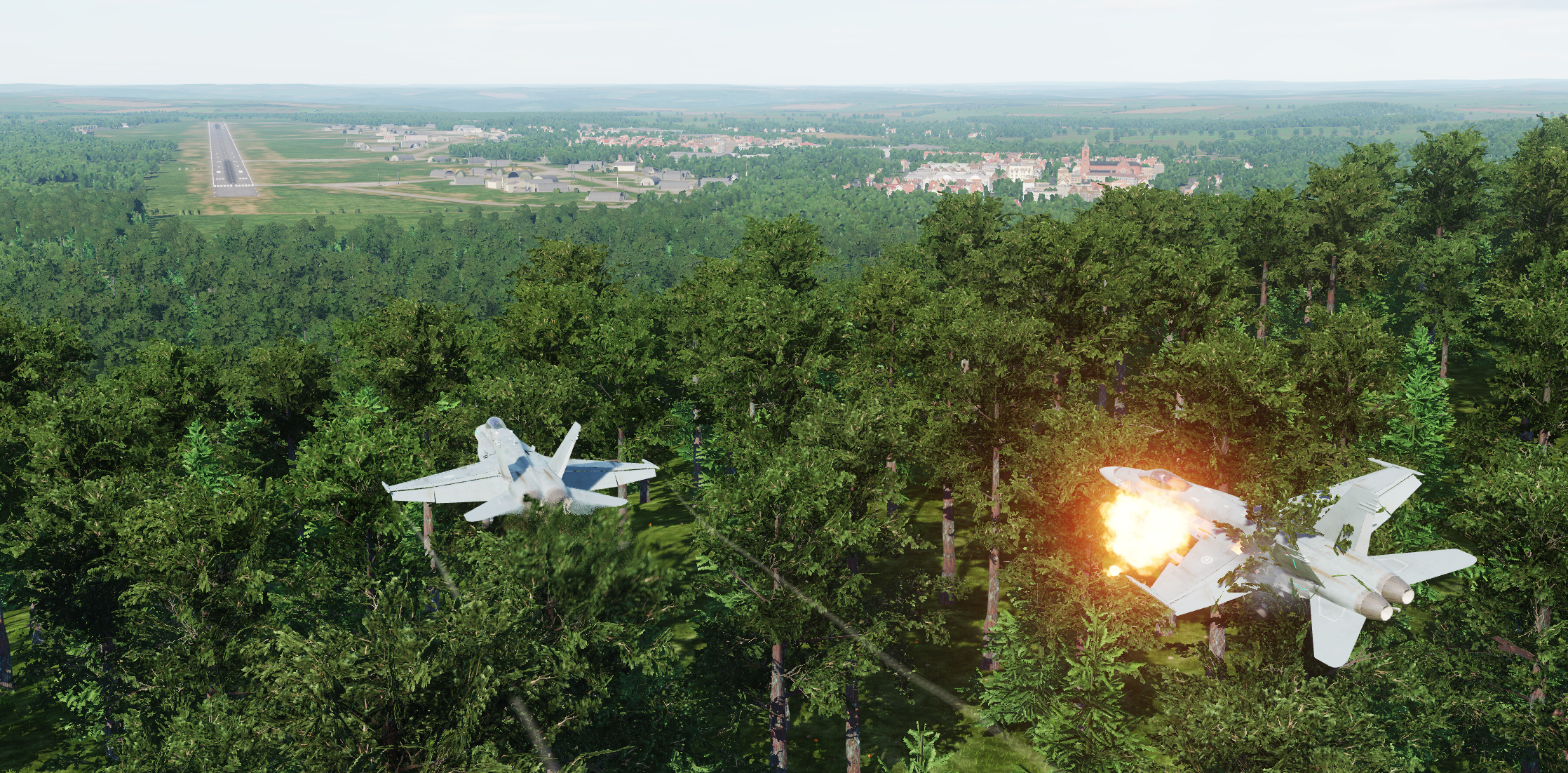
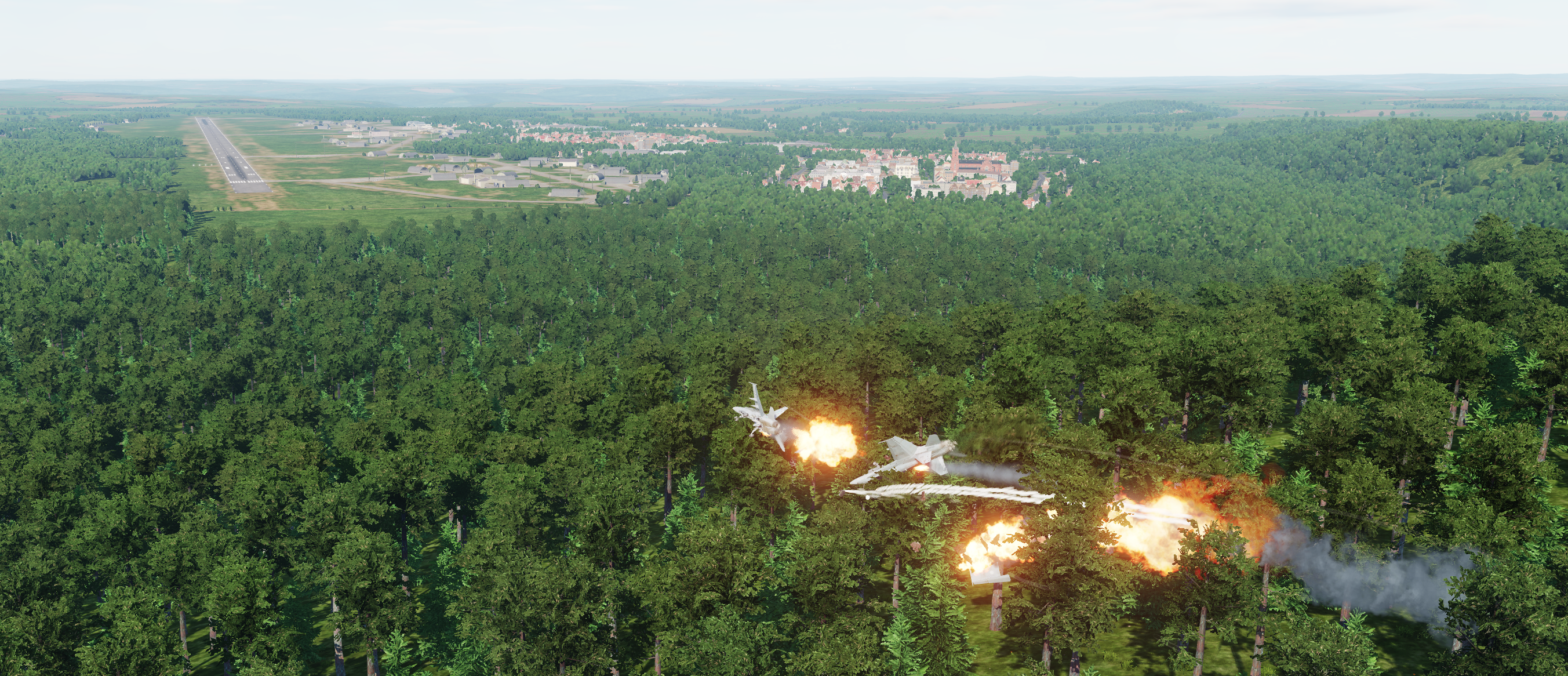
The big hill at the NE end of Spangdahlem means that AI aircraft always crash when trying to land on runway 23. This seems to be 100% reproducible, at least with the Hornet. (It's actually a pretty tricky approach for human pilots, too, but it's suicide for the AI). Broken AI Landing Spangdahlem.miz
3 points
-
I'm a professional software engineer, and have been for over a decade. When a bug like this lands on my desk, it's up to me to reproduce it. Not the customer. And then I fix it. If a customer reports a bug, support asks them to supply logs, they do so, and then I come back to tell my boss "actually I need them to stand on their head and use a hula-hoop at the same time" then he'd quite rightly tell me to stand on my head and use a hula-hoop at the same time. That's my job, not the customer's! This has been a persistent issue for at least a year now. Just Monday it broke again. I've produced a reproduction case, the fact that it requires another product which ED also sell has no bearing on the matter. It's not easy to reproduce. It doesn't happen on demand, and at the moment only happens maybe 20% of the time. Those are the worst kind of bugs to try to reproduce and fix, my absolute least favourite, and I'm sympathetic. Perhaps it only happens when there's a certain combination of factors? Fortunately I've provided a case of exactly that happening. That's also why I'm not putting in my own time to repro it; I get enough of that at work. Its literally not my job to diagnose other peoples' software for them, specially for free.3 points
-
Urga Media should implement your 2 fixes the airbases and other places look so much better with these 2 files removed. Sent from my CPH2333 using Tapatalk3 points
-
I can confirm Wunstorf is turned 9 degrees cw. 1991 FLIP chart says 262.5° for rwy 26 yet F10 map reads 271°. Spangdahlem 1991 FLIP chart reads 226.5° for rwy 23 and F10 map reads 236°, so 10° cw deviaton. Frankfurt rwy headings are 9° higher than published (for that time). Berlin airfields featuring no deviation is a hint that the map of this size struggles to project the converging meridians on a flat map scenery. It seems to be accurate at Berlin's longitude and then slowly turns clockwise the more west we go. Not sure if this can be avoided.3 points
-
This map is already a contender for "Best Map of All Time", IMHO. It's just fantastic! There are so many air bases, if the one you want isn't modeled, use a another base as a stand-in. I mean, they have to release it at some point and 120 bases is really a lot. I think the Fulda Gap focus probably provides for the highest number of air+ground scenarios. Oh one minor thing, Ctl+F12 isn't taking me to my train. I'm sure it was a minor consideration and rightfully so, just throwing it out there as an FYI.3 points


.thumb.jpg.4e1364f5c147f885cbea69ae1aa3e149.jpg)

.thumb.png.d43db0aa51621a39a2161ec5c6fff372.png)

.jpg.645d7fba6ea36b8eadbb831c9b6723e3.jpg)
1651346.thumb.png.26571e1dc9c44c276fd68e125fd124d2.png)


-
Recently Browsing 0 members
- No registered users viewing this page.