Ironhand
-
Posts
6281 -
Joined
-
Last visited
-
Days Won
20
Content Type
Profiles
Forums
Events
Everything posted by Ironhand
-
Well...almost. The BVR AA mode displays TAS on the HUD, while every other mode--the various WVR AA modes and NAV--display IAS. BVR displays TAS because you need to quickly calculate closure rates, etc and IAS doesn't allow you to do that at all. Or that's my take on it. anyway. Oh, and "Reticle" mode displays no airspeed at all.
-

Order wingman/fight to attack/left right bandit
Ironhand replied to Gunfreak's topic in DCS Core Wish List
That works as long as the aircraft your flight uses has radar, of course. -
What you’re looking for is how to set up custom Snapviews. Google DCS Snapviews and you’ll have the info you need for setting them up for yourself.
-
MiG-29's BFM characteristics / doubts
Ironhand replied to Top Jockey's topic in MiG-29 for DCS World
IIRC, when the Mirage was released, low energy excessive maneuverability was an issue. Did that ever get fixed? Don’t own it myself, so I haven’t paid much attention. -
MiG-29's BFM characteristics / doubts
Ironhand replied to Top Jockey's topic in MiG-29 for DCS World
Regardless of what was said in the interview, the only way you will know, if anything is amiss, is to get the G and turn rate graphs for each aircraft and see how closely the DCS versions hew to it. You’d need to match each aircraft’s graph in terms of fuel, missiles (if any) gross weight and altitude. Anything other comparison just leads to confusion. -
MiG-29's BFM characteristics / doubts
Ironhand replied to Top Jockey's topic in MiG-29 for DCS World
Kind of hard to tell if something is amiss without the STRs. Your G numbers for the Mirage 310-370 kt range seem reasonable. -
how to lock up a target w Radar or IRST
Ironhand replied to skypickle's topic in Su-27 for DCS World
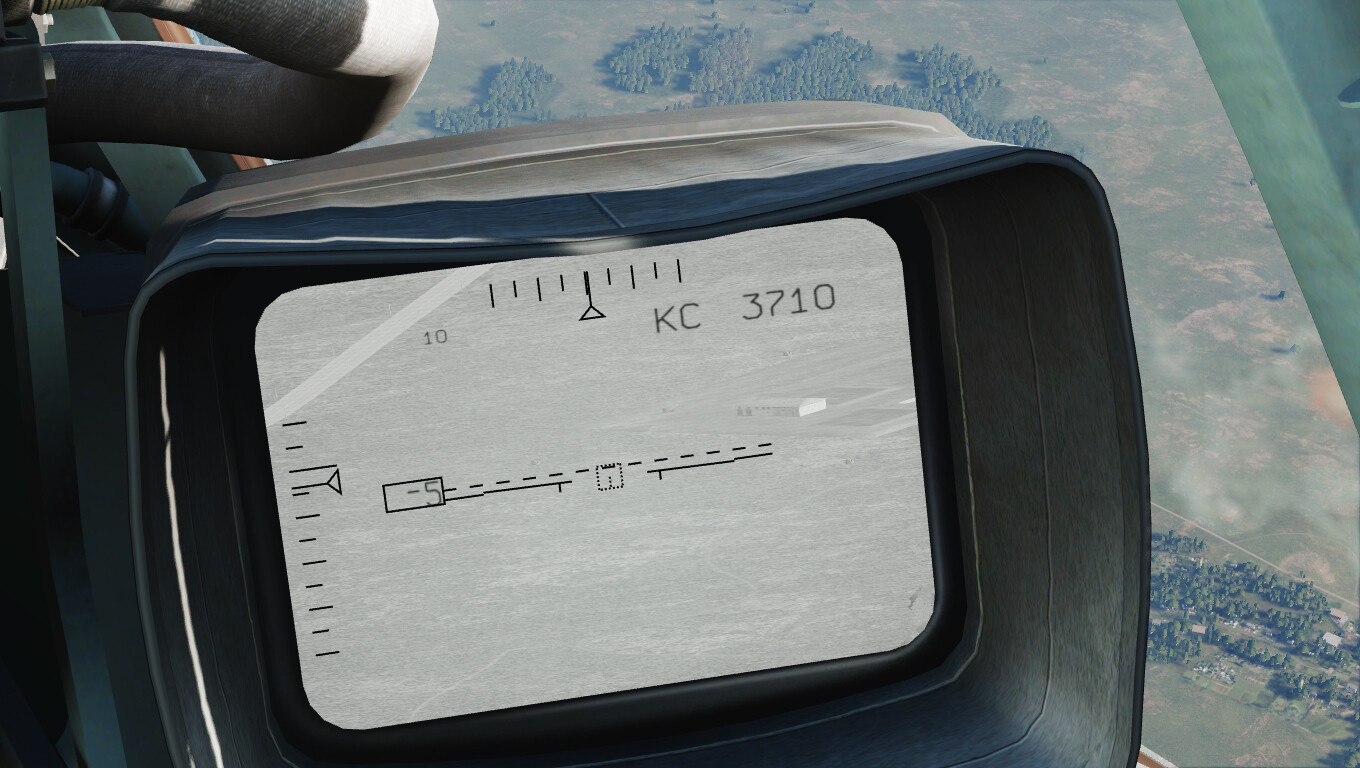
That section on missile engagement with EOS as primary is something of a hot mess. Among other things, it tells you to move the radar azimuth scan zone right or left. That aside, SST is short for Single Target Track and EOS is not developing any sort of track. It's simply holding a target lock and informing the IR missiles of the type selected where to look to get their own lock. In the real world manual, an STT type lock is never mentioned. Regardless of what the DCS manual states, you can't change the target range because the default setting in the real world, when the range is unknown, is 10 km. DCS uses that but then automates range measurement as coming from the laser or radar to set the range scale. -
how to lock up a target w Radar or IRST
Ironhand replied to skypickle's topic in Su-27 for DCS World
I’m a bit confused here. STT is one of the radar complex’s modes and is not a function of the electro-optical system. I’m guessing that you are only using the EOS and that the radar is off. Once EOS has the target locked, the target’s angular coordinates are sent to the seekers of the selected IR missile type which then attempt a lock of their own. In the sim, once they have a lock and all other parameters are within acceptable limits, you will get launch authorization. The launch itself provides no warning to the target because, other than the rocket motor igniting and the missile being released from the rail, nothing changes. Range being one of those parameters, it comes from one of two places: either the laser rangefinder or, in the real world, the radar operating in quasi-survey mode. -
There is no stick limiter override indicator in the cockpit because, in the real world, you override the limiter by pulling harder on the stick. In the sim, there’s a setting to mimic the harder pull, instead. EDIT: Never answered the first part of the question. No. It's not a toggle. Press and hold for as long as you want the override function.
-
Known issue:
-
reported Su-27 autopilot and trim
Ironhand replied to Volator's topic in Flaming Cliffs Bugs & Problems
Here's a TRK file demonstrating the issue. I engage baro altitude hold and, then, disenage it at close to the same airspeed and there is little trim difference. I then reengage baro altitude hold and increase speed. Upon disengaging the ACS, the nose pitches up severely due to the trim reverting to the "lower speed" trim. Su-27 ACS Issue.trk -
As you’ve discovered, even at its simplest, DCS is quite complex. My only advice is to not try to accomplish everything at once. What I do for any new aircraft is to set up my HOTAS for the flight basics first. So things like flaps, landing gear, trim, etc. Then I practice circuits with touch and goes until I have a good feel for the aircraft in those configurations. After that, I’ll takeoff, make a high speed run, come back and land to get a feel for the speed transitions. After you have a good feel for the aircraft, it’s time to start using it as a weapons platform. If it’s dual role, pick one—either A2A or A2G. If the latter, start with simple iron bombs. Whichever platform you choose, set the basics up on your HOTAS and proceed from there. You’ll find taking small steps less frustrating than trying to run right from the start.
-
reported Su-27 autopilot and trim
Ironhand replied to Volator's topic in Flaming Cliffs Bugs & Problems
What you are experiencing is a bug. You should report it as such. In DCS’s Su-27, when you disengage the ACS, the system seems to revert to the trim setting you had before engaging it. This is impossible as it has no such “memory” function. The real world manual cautions against disengaging by moving the stick because it can cause transient extreme roll, etc. But the is no such caution in regard to disengaging the system properly. -
Just realized that, in viewing your TRK, there are cockpit shadows. The Shkval screen is in shadow but the contrast is less for some reason.
-
Draconus beat me to it. But, since I made it, I’d might as well post it:
-
Yes, though it was a bit more obvious on my monitor. But better contrast would be a major improvement.
-
It’s been a thing, since the Flaming Cliffs 1.x days if not before.
-
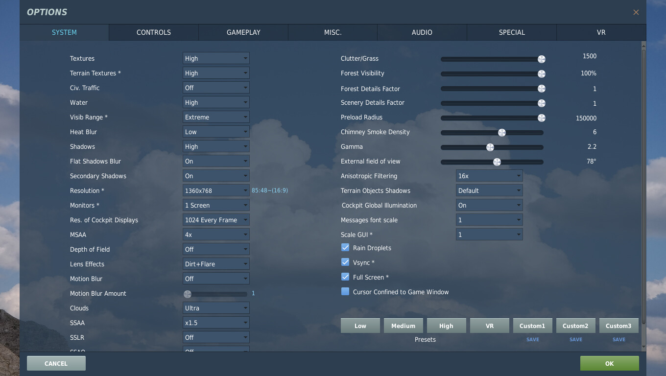
Watched your TRK and didn't have a problem seeing things, though the contrast is admittedly low. Could it be a settings issue? Or, perhaps, your monitor settings? Here are my settings, in case that's the issue:

-
To fly the Su-27 and, to a lesser degree, the MiG-29 followed by the Su-25, and Su-25T. I’ve been flying the Flanker, since ED came out with her in the late 90’s. If she ends up MAC-only, then that’s where I’ll have to go as well.
-
From Matt's 2018 PC Pilot interview: 1) 2) Most likely not. 4. Seems not.
-
[SAMs] P-14 "Tall King" as search radar for SA-5 "Gammon"
Ironhand replied to Wild_Weasel_31's topic in DCS Core Wish List
S-200 Title reads: General Information About the S-200 Anti-aircraft Missile System and 5B21A Rocket. -
For some of us, age and health inform the length of time we have available for waiting.
-
Ahhh…I found that definition, when I looked it up, but didn’t make the connection. Thanks. The operative word is “someday” which means, most probably, not in my lifetime…unfortunately.
-
For the uninitiated among us, what does this mean?
-
The limiting factor for RedFor aircraft is political/governmental rather than ED’s decision to only produce FF modules. I fly FC3 because I fly the Su-27 and MiG-29. If they were FF modules, that’s what I’d be flying instead.