Ramsay
-
Posts
3750 -
Joined
-
Last visited
Content Type
Profiles
Forums
Events
Everything posted by Ramsay
-
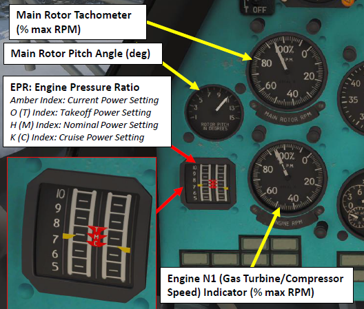
I've flown the DCS Mi-8 for a few years and am aware of it's quirks, the main issue is when returning with Huey and Gazelle muscle memory. I find the DCS Mi-8 particularly sensitive to descent speed when transitioning to a stationary IGE hover. In the past I was able to use the variometer but these days it seems slower to react and the helicopter seems to perhaps enter a "reverse" ground effect - I know it sounds stupid but, in the past, we've seen such things (bugs) in the F5 and F/A-18C flight models. The best graph of how the current DCS VRS "feels" (to me) is this one from the Russian forum (red is DCS, blue is real). https://forums.eagle.ru/topic/95108-bagi-problemy-velikolepnoj-vosmerki/?do=findComment&comment=4678200 As a workaround for the slow variometer and VRS sensitivity (~2m/s) in certain phases of a landing, I found knowing the Mi-8's IGE Hover Rotor Blade Pitch Angle a good predictor (much in the same way you'd use torque in the Gazelle or KW).
-
The sound files (e.g. 'Spud 03 1s.ogg') are packed inside the .miz When DCS plays a mission the mission's files, pictures, sound files, etc. are unpacked in a temporary folder.
-
Same, I find making note of the blade pitch angle req'ed for IGE hover helps

-
DCS's AWACS BRA calls use True. So • BRA, 348 for 110, at 25000, flanking ... will be at 348°T i.e. as measured on the F10 map. However the Mirage Heading tape and radar use magnet bearings, so the contact would be seen/detected at 342°M* * Assumes a Caucasus MagVar = +6°E The kneeboard page "KNEEBOARD\IMAGES\Kneeboard_2.jpg" has a typo in the ILS frequency, can't say I noticed it as I've always referred to the briefing pages (LAlt+B).
-
IRL it takes 2 differently scaled paper maps, cut into 220×168mm sheets so they cover the required zone. There's a moving "+" fitted to a transparent tape that's driven by the doppler radar system. You set the scale appropriately, position the "+" at your current location on the map, the doppler system then moves the "+" as the aircraft flies. If the doppler system drifts to much, you'll adjust the "+" to be closer to your current location i.e. using visual landmarks. DCS is modelling most of the system. As it's a paper map IRL - DCS also shows the waypoints/route drawn on the map. DCS Screen shot In the above example the route leg is distance (km) 20.0 km --------------- HEADING = -------- 130° time (minutes) 04 min ? More detail about the moving map here: https://forums.eagle.ru/showthread.php?p=4456963#post4456963 In operation https://youtu.be/DH_FNrZXgms?t=1007
-
As titled, the Russian UN skin is currently only available to Russia DCS World\Bazar\Liveries\mi-8mt\Russia_UN\desciption.lua name = "RF UN" name_ru = "ООН (Россия)" countries = {"RUS"} Now that United Nations Peacekeepers faction has been added to DCS, it would make sense to add them to it's list of countries, example below: name = "RF UN" name_ru = "ООН (Россия)" countries = {"RUS","UN"} Tested DCS 2.7.1.7139 Associated thread https://forums.eagle.ru/topic/273818-mi-8-un-skin-not-available-if-country-is-un-peacekeeper/ Note: The same could be done for: Mi-8 China UN, Ukraine M-24V UN and the Huey's USA, Spanish and Norwegian UN skins • DCS World\Bazar\Liveries\mi-8mt\China UN • DCS World\Bazar\Liveries\mi-24v\Ukraine UN • DCS World\Bazar\Liveries\uh-1h\USA UN • DCS World\Bazar\Liveries\uh-1h\Spanish UN • DCS World\Bazar\Liveries\uh-1h\Norwegian UN There's also • DCS World\Bazar\Liveries\uh-60a\ISRAIL_UN\description.lua • DCS World\Bazar\Liveries\Mi-26\United Nations\description.lua ... that might want updating for the UN faction but I haven't checked in detail.
-
Correct. Agreed
-
You are doing nothing wrong, the skin's description.lua makes the UN skin available only to Russia. name = "RF UN" name_ru = "ООН (Россия)" countries = {"RUS"} You can copy the skin folder "DCS World\Bazar\Liveries\mi-8mt\Russia_UN" to "Saved Games\DCS\_Mods\Skins Mi-8\Liveries\mi-8mt\UN" and edit it's description.lua so the skin uses the United Nations country code "UN" i.e. name = "UN skin" name_ru = "ООН (Россия)" countries = {"UN"} or be a default skin* available to all name = "UN skin" name_ru = "ООН (Россия)" countries = {} * Note: this has the disadvantage that it'll become the default skin for the all countries without their own skin (rather than the Russian military skin which gets used because there is no other). More detail on country codes can be found here https://forums.eagle.ru/topic/142528-how-to-use-the-same-skin-across-several-countries/?do=findComment&comment=4527200
-
The "♦" IFF replies are displayed for 1 full scan i.e. a 4 bar scan might display x4 "♦" replies from a single friendly contact (as it's been swept/interrogated x4 - so replied x4) before the VTB's IFF replies age out (drop). Switching to a 2 bar scan and scanning the same friendly, we get x2 "♦" replies. A 1 bar scan would display x1 "♦" IFF for each replying aircraft before the "♦" IFF start aging. I don't recall the dev's being asked about a display limit, think we were all too busy guessing at what we were looking at. *** It's important to note ALL OF THIS IS EARLY WIP AND MAY CHANGE BEFORE WE EVER GET OUR HANDS ON IT ***
-
The Mirage's A2A radar is being rebuilt from scratch to be more representative of the real. This was a WIP "teaser" of the new IFF behaviour that's coming, perhaps it's usability will improve as features are added, however it's equally possible it's a limitation of it's 80's tech*. * Note the IFF is less ambiguous with a radar contact V, as although the IFF "♦" jitters about, the multiple "V"'s jitter much less as they are being scanned by a tighter 3° beam. longer version @2:54 /8MB https://cdn.discordapp.com/attachments/544216334045544448/846695516159082526/Digital_Combat_Simulator_2021-05-25_12-12-53-1.mp4 As this is being modelled with/for the AdA, I can only wait with you to see what Razbam deliver.
-
The IFF antennas are mounted on the main radar "dish" but cover a 10° cone, while the main beam covers only 3°. When a IFF interrogation is made, the reply may come when the main beam is to the left or right of the target or even scanning a different "bar" i.e. the main beam may be scanning above/below the contact and it's not even displayed on the VTB (only it's IFF reply). For example - at 0:32 it looks like two friendlies replied from ~43 NM distant (two replies per sweep?) but have not been detected by the radar (perhaps they were cold (the radar has much less range vs cold targets) or lost in ground clutter ?).
-
Video and simulator footage of VRS and LTE
Ramsay replied to Rabies's topic in DCS: Mi-8MTV2 Magnificent Eight
AFAIK - immediately reduce collective • landing if close to the ground and it's safe to do so or • increase forward speed (re-enter translational lift) • re-assess power available/wind direction • divert (or re-attempt landing if safe to do so) The problem with LTE is that, near the ground, the instinctive reaction is to increase collective, which further reduces the tail rotor's effectiveness. Note: Although the DCS Mi-8 models torque and weather cocking, it does not model LTE due main rotor vortices or tail rotor VRS due to crosswinds etc. AFAIK DCS's tail rotor is much more effective than the real when operating with an adverse cross/tail wind. -
Yes, they had a choice, release an incomplete EA module that didn't meet their goals or wait until it was a something they could be proud of. IMHO they may have lost money/timeliness in their delay but as a "company" they went up in respect.
-
No one has paid for the Kiowa, PC are not obligated to give a monthly progress report beyond "work is in progress and we hope to deliver before the end of the year". The team is small, it's likely impossible to give details on delays without revealing personal details or throwing a team member or business partner "under the bus" for a failing i.e. developing new code/systems is hard, SME feedback is iterative, ED update, exam deadlines, new job, full time work commitments, personal crisis/emergency/change of circumstance, etc., etc. If I was PC, I'd likely apologise for not replying sooner while repeating their previous statement IMHO, that's all that's needed as ... ... has already been covered in past streams and there's no need for PC to self flagellate or show "how the sausage gets made".
-
No PC do not. Your quoted post is from 26th Jan 2021 (nice snip making it look like it's from yesterday i.e. topical) The Gazelle video in question was misleading, it (deliberately ?) cut away from the cockpit just before it's cockpit warnings triggered and the engine cut out. In the video "flashgod" rolled inverted (engine cutout), auto-rotated while inverted and rolled right way up for a auto-rotative landing. It's a hard manoeuvre and even in DCS it's easy to overspeed/break the rotor. It took several attempts before other players could reproduced it. Inverted auto-rotations are not a good example to use when talking about the Gazelle's flight model. No it does not, PC seemed to spend quite a lot of time investigating the report and took the time to run THREE twitch streams in February discussing helicopter flight models in other sims, in DCS, what the Gazelle got right, what the Gazelle got wrong and the lessons learned being carried forward to the Kiowa's FM.
-
Hind tempting, obviously, but what exactly are we going to do with it?
Ramsay replied to AvroLanc's topic in DCS: Mi-24P Hind
If you like the idea of a Mi-8 "upgraded" with better weapons systems, ATGM's and R-60's it's a no brainer. Start up and navigation is built round the Hind's pilot, so ergonomically the cockpit should be better than the Hip which is design for a crew of 3. Not sure how restrictive the cockpit view will be or how easy it'll be to "throw around", I'm guessing it'll still have a lot of similarities to the Hip but with a different focus. -
AFAIK Razbam's PCA/AG/AG radar update has been sent to ED, however it either missed the last patch (for reasons) or ED are focused on fixing core bugs in 2.7.x (so aren't pushing out 3rd party updates).
-
INS training mission 02 - issues recalibrating / training stuck
Ramsay replied to Althar93's topic in Training Missions
Here is the overfly update ... and here is me playing with OBL to update the INS so the waypoint is on the bridge and later deliberately move it to the "wrong" bridge As I said ... ... if you've been able to move the waypoint "+" around the bridge using overfly and OBL (radar offset/oblique) INS updating, there is nothing more to learn. AFAIK it is looking for the REC and VAL cockpit arguments being pressed within the landmark's trigger zone. It's possible the argument numbers have changed or are not working in Open Beta i.e. VAL switch 580 was using argument 581 and the mission triggers used to work. -
Issue - L-39 Airspeed in Knots when avionics language set to english.
Ramsay replied to v81's topic in DCS: L-39 Albatros
Not sure there was a mod, IIRC someone once asked for better imperial instruments but a alternative English cockpit and metric or imperial instruments are a standard feature. • Options>Special>L-39 to choose the cockpit default (Russian) or English • Options>Gameplay --->Units to choose Imperial or Metric instruments This picture is from DCS 1.5.x ... checking Open Beta 2.7.1.7029, it's the same, so I'm not sure why people think something has changed ?
-
The 120 GB install is for the base install, Syria on it's own takes another ~52 GB of space. It makes total sense, I own more modules than you but if I add up the sizes of the modules you own, I get a very similar size 72.3 GB DCS Base (models, weapons, data base, liveries, etc. 0.9 GB (924 MB) 2 free aircraft (Su-25T and TF-51D) 16.3 GB Caucasus 1.5 GB Flaming Cliffs 3.6 GB F-14 33.2 GB Persian Gulf 51.6 GB Syria ===================== 179.4 GB TOTAL INSTALL I use Symbolic Links (symlinks) to move the larger maps from my M.2 system drive to another SSD, perhaps you can do something similar ?
-
INS training mission 02 - issues recalibrating / training stuck
Ramsay replied to Althar93's topic in Training Missions
The training Mission is currently bugged and doesn't proceed/trigger after the bridge overfly update - likely broken by the latest changes, 2.7.x update, etc. Both overfly and OBL(radar offset) updates are working correctly in Open Beta 2.7.1.6709 More detail here -
reported On Vortex Ring State from active Mi-8 instructor
Ramsay replied to cw4ogden's topic in Bugs and Problems
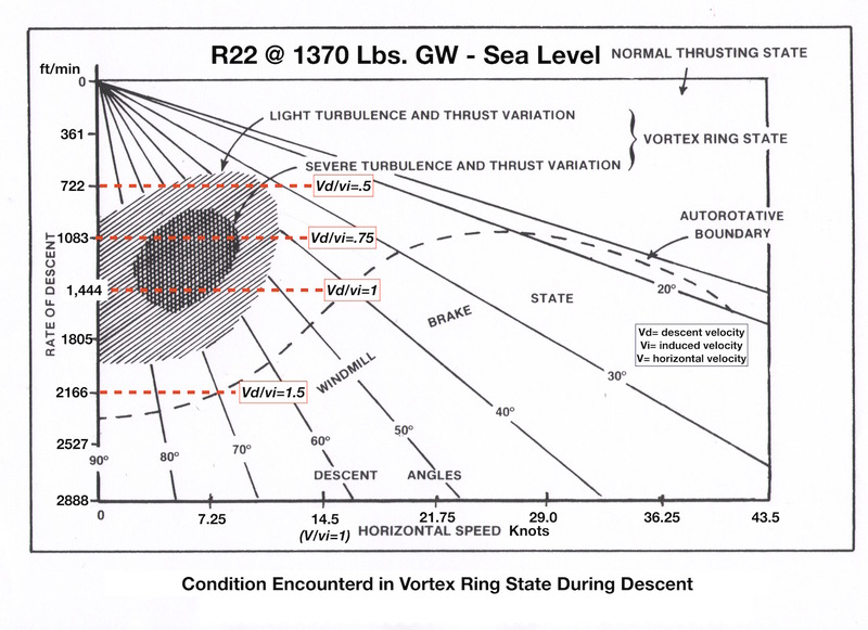
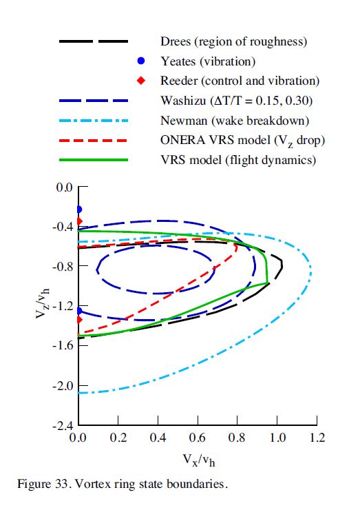
Unfortunately I don't have an easily quotable source - I don't recall the exact web pages, some where a mix of free form diagrams, text and maths and used different variables but it became pretty obvious that Vz/Vh, Vd/vi, etc. were ratios with respect to the theoretical downwash i.e. this chart for the R22 using Vd/vi or this using Vz/Vh (from "Model for Vortex Ring State Influence on Rotorcraft Flight Dynamics", ADA526709.pdf) where Vh is defined on it's front page as Square root of (T/(2 x ρ x A)) These use equivalent scales where Vi and Vh = the velocity of the theoretical downwash
-
reported On Vortex Ring State from active Mi-8 instructor
Ramsay replied to cw4ogden's topic in Bugs and Problems
I'm sure you know this but for those that don't, the generic VRS chart is given in terms of the theoretical downwash where 1 = Vih = Theoretical downwash = Square root of (T/(2xρxA)) A little more detail on how to calculate the Theoretical down wash VRS = 700 ft/min is a specific value when the generic chart has been scaled/labelled for a R22's theoretical down wash. -
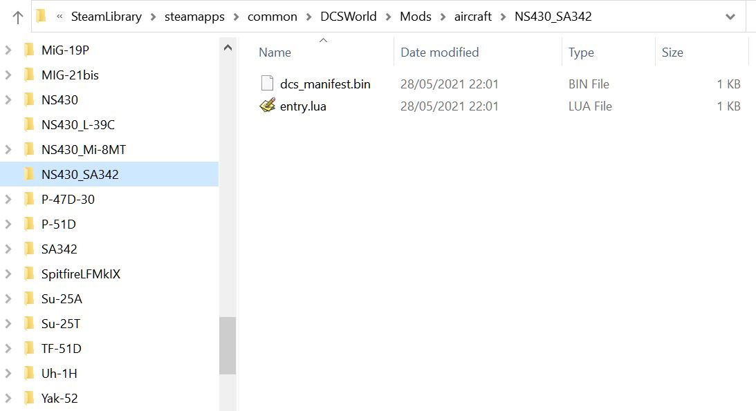
Correct. Only after I converted a Steam install to DCS Standalone, bought and installed the Gazelle NS430 module did your mission display the Gazelle's NS430 cockpit model. Note the additional "NS430_SA342" folder in the standalone install, AFAIK "entry.lua" registers the NS430 Gazelle plugin.