Leaderboard

Popular Content
Showing content with the highest reputation on 04/24/25 in all areas
-
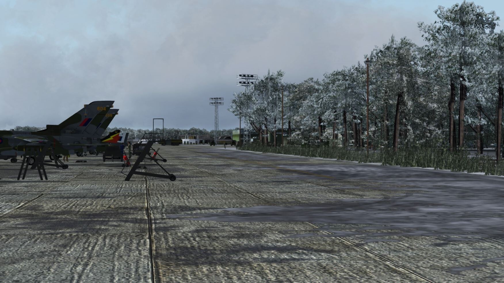
Having already written a whinging post regarding the questionable representation of the NATO airbases included in the initial release of the map else where in this forum, I would like to make a thread of my own regarding a couple of other "niggles" that are bugging me personally. Forgive me if some of the points made herein have been brought up elsewhere in the forum, but this is my post, consider me reiterating said points... Context: In my understanding, this map is being sold as a Cold War map, circa (at a guess) 60's through to late 80's / very early 90's. 1. Why are there racing cones all over the military low flying routes? The "coned" air racing ala Red Bull style did not become a thing, certainly in Germany, until the early 2000's and would most definitely not be located along or intersecting NATO low flying areas. Now, before anyone educates me on the history of air racing, I do appreciate that the sport has been a thing since the dawn of manned powered flight, but it was not present as represented during the stated time period of this map. Please forgive my ignorance, but might there be a way to hide or remove these cones on the map via the mission editor, or perhaps to remove the specific (offending) cone file from the map folder? I don't know how anyone else feels, but they break the immersion of flying in a "Cold War" environment. Of course, I do appreciate the "fun" factor and it's an extra selling point for the map, but... 2. NATO Flightline equipment. This may be something of an emotive subject, but why are the bases populated with non-military specific and most definitely civilian flightline items? Once again, would anyone know how to remove these most offensive objects? To my mind, these inane items could have been left out, saving the resources for elsewhere on the map. A side note: a. One of the big issues we had whilst low flying (anywhere in Europe) was gliders/paragliders, etc. Gliding was/is a big sport in Germany, and care had to be taken in flight planning to avoid such areas on given days of the week. I feel this would be a good addition to the map. Understandably, most of the big gliding areas were located outside of the map area, being further south (notably Stuttgart), but there were a few in the Rhine/Westphalia area. Of interest, has anyone thought of creating a glider mod? b. Is there any possibility of extending the map westwards to include at least the entirety of the Netherlands? So many important locations there, airbases (Leeuwarden, Volkel, Soesterburg, Gilze-Rijen) and weapons ranges (most notably the famous Vliehors Air Weapons Range, otherwise known as the Cornfield Range). Also, perhaps stretching the map to include more of Belgium, featuring Florennes, Beauvechain, and Kliene Brogel? I ask as considering the range of Phase 3, it seems a wasted opportunity not to include the entirety of the Low Countries and their important Cold War bases. c. Will Ugra Media include the Nordhorn Weapons range? In my mind, this is an absolute must if the moniker "Cold War" is to be taken as such. I realise that I might be presenting myself as something of a "Debby Downer" or "nit picker" with this post, if so, that is not my intention. I am grateful for all of Ugra Media's efforts in bringing such an important and much requested map. This map was a huge undertaking, and overall, Ugra has done a superb job. I feel there is room for improvement/changes. Having paid our money based on expectations according to the sales pitch (Cold War Germany), we all have the right to a voice of opinion. I appreciate that this is an initial release and some (hopefully all) of the "niggles" maybe addressed in future updates. Thank you, one and all, for once more putting up with my words. My utmost gratitude to everyone at Ugra Media for releasing one of the best maps for DCS, certainly the one with the most potential.8 points
-
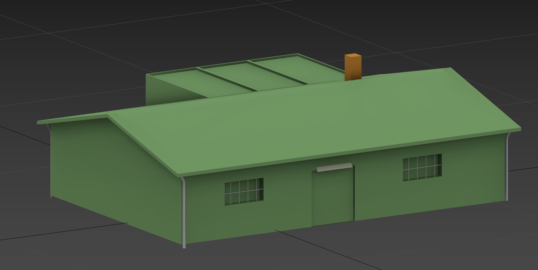
It's not ready for the public just yet. Still need to do some 3d touch ups and FM stuff.6 points
-
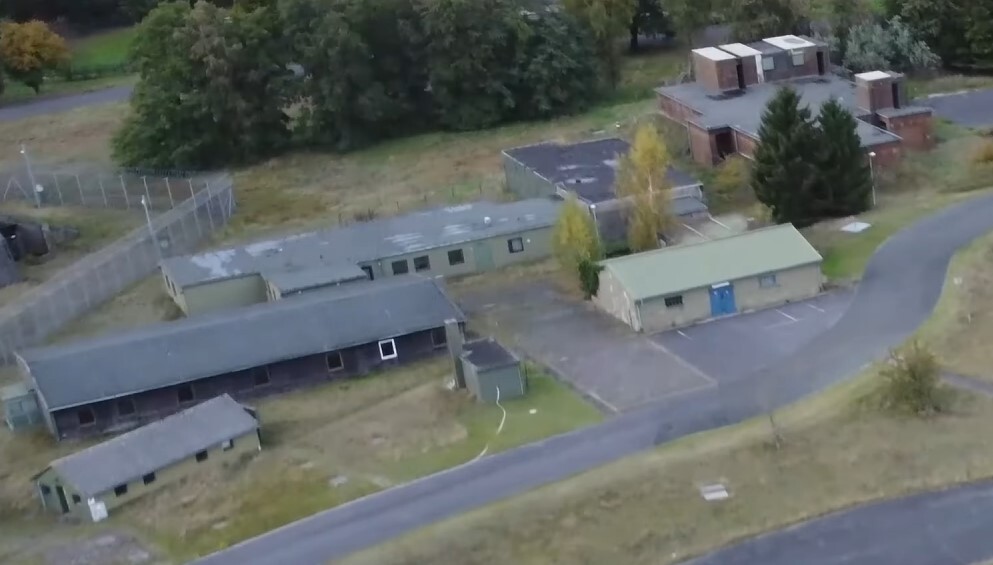
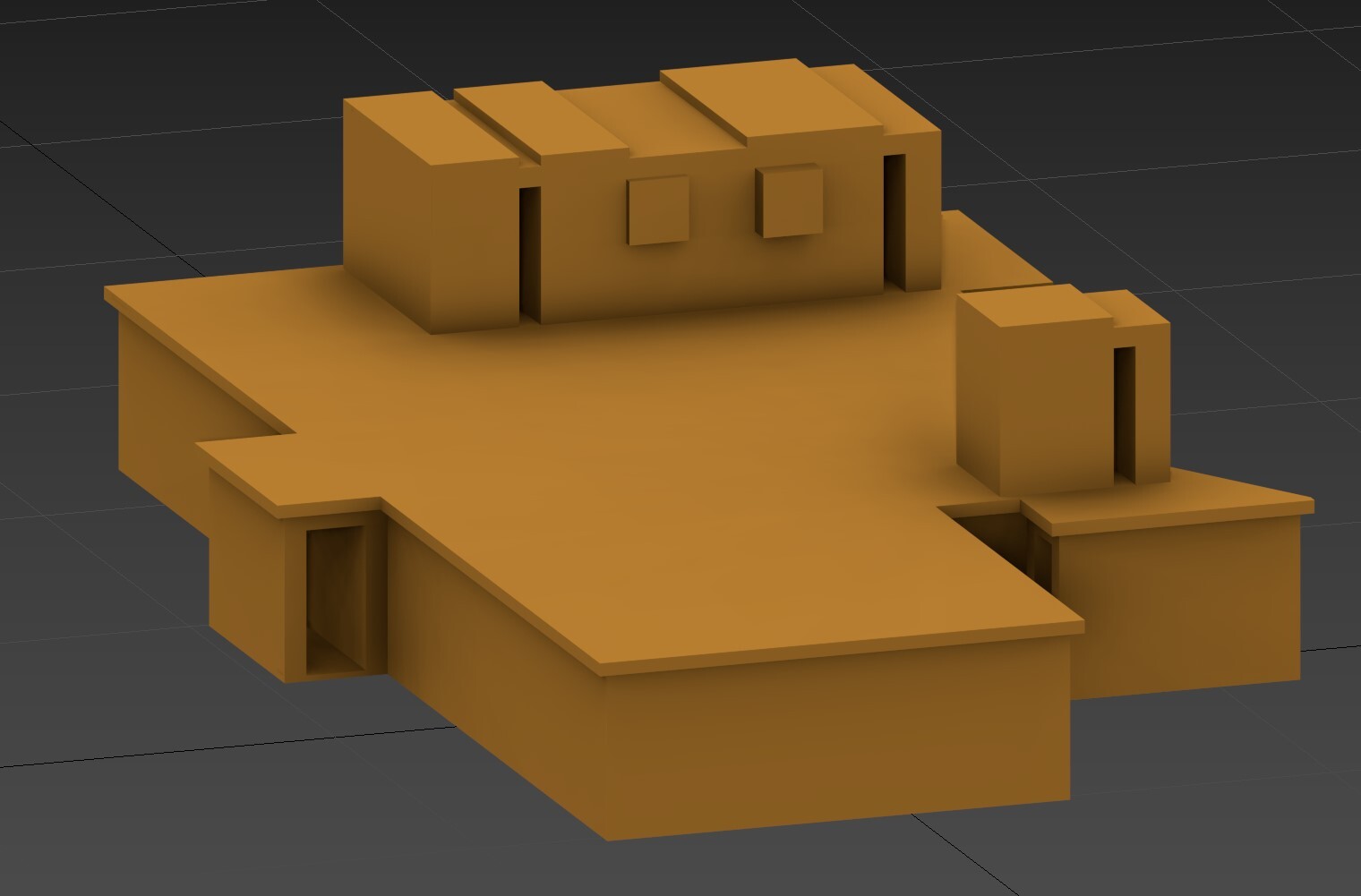
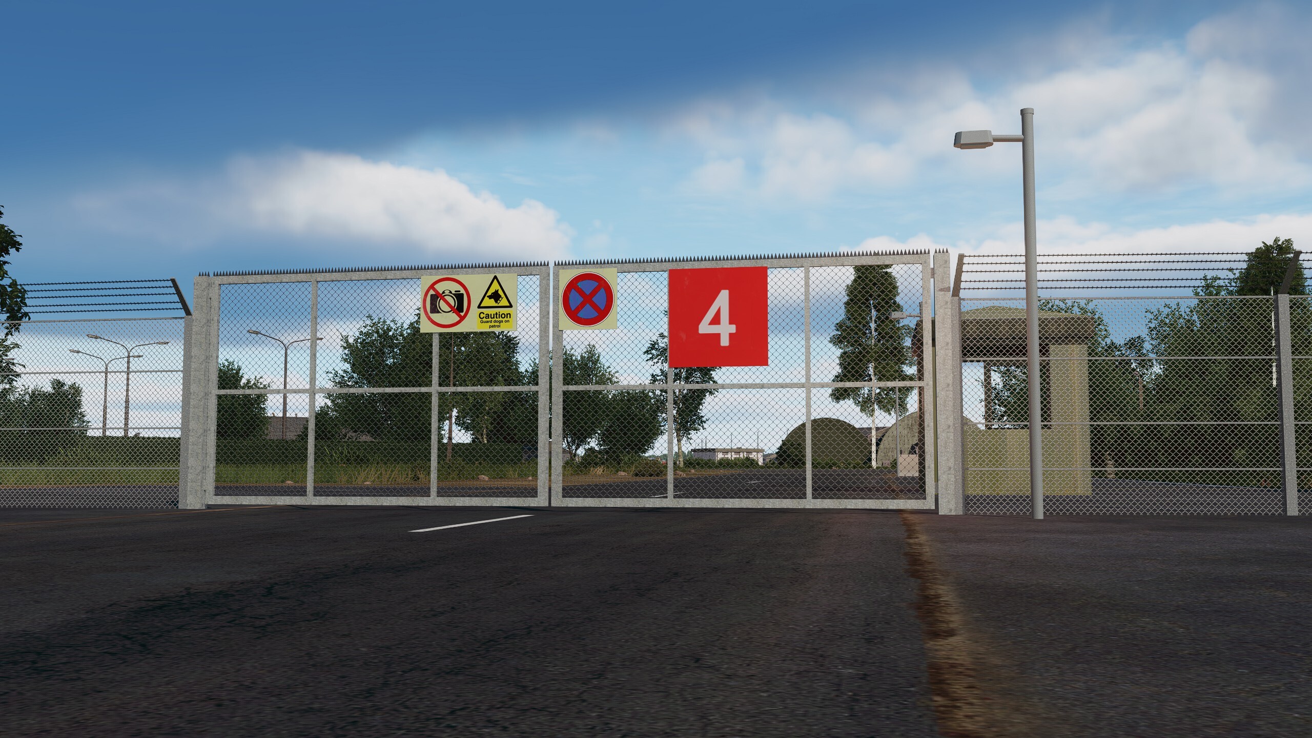
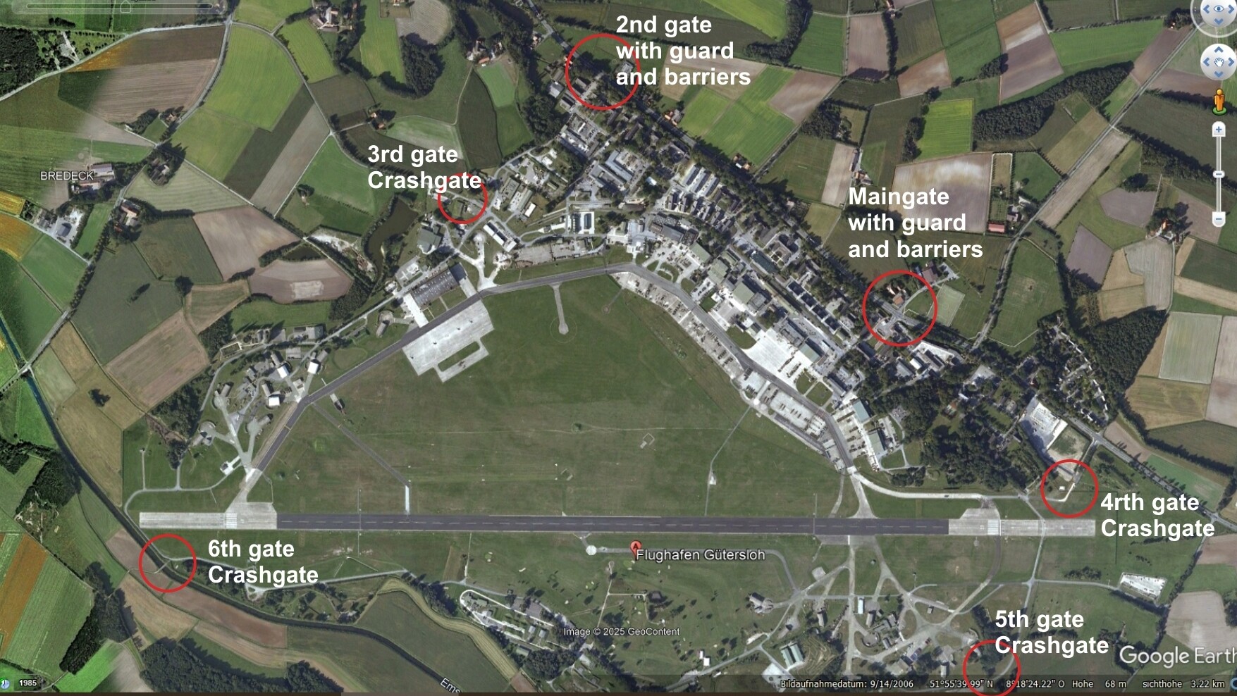
Yes @Manschy, i have a very busy and crazy life, sooner or later it will not work without a donation page seriously. its a tremendous effort to create all this... RAF Brüggen... nice... @Tengah it all depends, there's 80% undone of Gütersloh for now so... lets wait and see how people react, support and what UGRA Media does... again the Aircraft shelters are of no use right now since you can not use that parking spot nomore, they need to implement the shelter... or ED makes the KI "smarter". I have a personal connection to RAF Brüggen. Back then, some of my relatives lived just 35 kilometers (22 miles) from the Brüggen Airbase. The full story is too long to tell, but it came to a swift and sorrowful end. Yes, I was that little boy in the mid-90s, standing by the fence of RAF Brüggen with his bicycle and analog camera, watching the Tornados fly with awe, often until the very end of the day’s operations. A world that no longer exists. memeories long ago..I never went back. Anyway... Ugra created way way to many buildings around the gates, every Airbase has 1 Maingate and maybe a second gate that might open for some type of maneuvers/operations. (I had to laugh when i saw the eagle head on the western gate ) The rest are "Crash gates". I created one, nit detail, each gate might have its own number.. i think i found an easy way.. fences and guard booth are from older projects, then i finished the model for the "bunker" type building which is located in the western and southern shelter area, plus simple model for one of the office type buildings, more to follow...
 6 points
 -
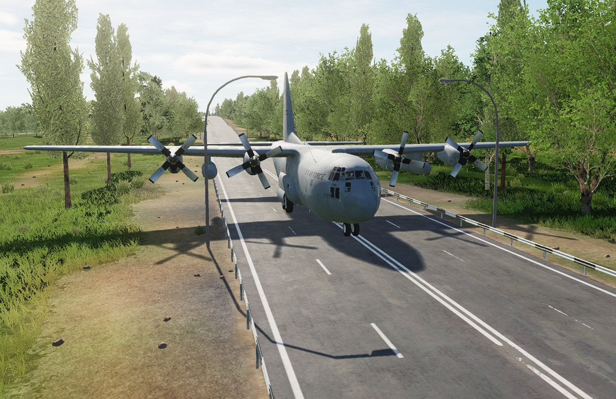
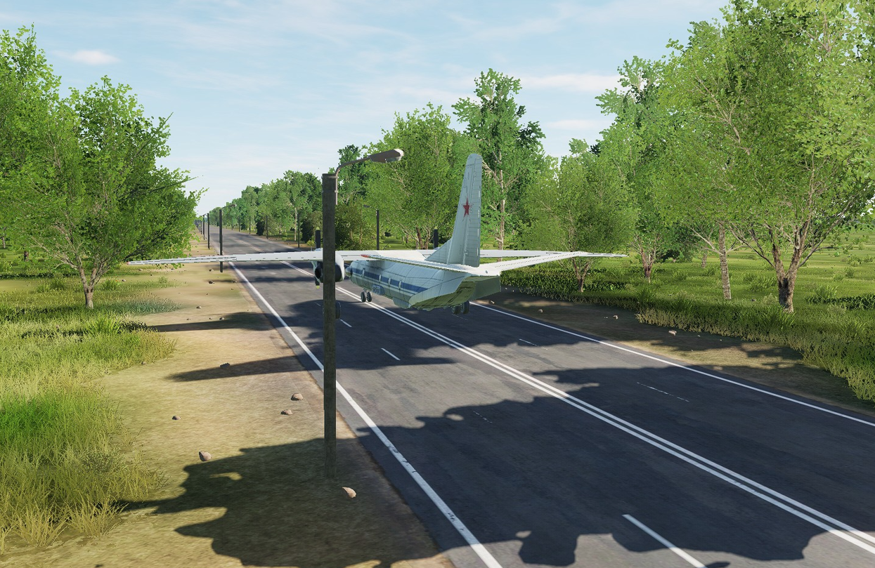
A major topic during the Cold War in Germany were the road air strips, which were to be used as alternative airports in the event of war. These road air strips existed in both east and west. Unfortunately, these motorway sections cannot be used in the CW Germany map. The motorways are too narrow, blocked by lighting and trees and some are not level. The car parks that were used as service areas for the aircraft are also missing. I know that it is impossible to integrate all road air strips, but 5-6 per coalition would be very nice https://de.wikipedia.org/wiki/Notlandeplatz_auf_Straße nullnull Picture 1 and 2 show the same place (A29 - 52°54'44.0"N 8°09'58.0"E) in reality and in DCS (picture from defence-network.com) Picture 3: A44 Bueren Geseke - 51°35'50.0"N 8°33'06.0"Enull Picture 4: A9 Dessau-Süd und Zörbig - 51°40'35.0"N 12°12'23.0"E
5 points
-
Joey45 is developing it. I've been helping with some of the coding. There is a thread for it here but I believe the work in progress build is only posted on his discord. So you may have to ask him for an invite. I need to send him my latest build, but he may have already fixed/updated some of the stuff I've done. I'm not sure if he has a release date in mind.5 points
-
Little tour of West Berlin in the OH-64 points
-
Never understood why people rush to justify things that are pointed out as wrong, inaccurate, below standard etc..... I am sure Ugra take their products and their reputation very seriously and would be very happy to use these pointers to further improve an ready excellent product. Why is there so much fanboi-ism surrounding any criticism of anything in DCS? Fully agree regarding the spurious detail included in things that dont really matter at the expense of more important big picture stuff Its a lovely map though, done extremely well4 points
-
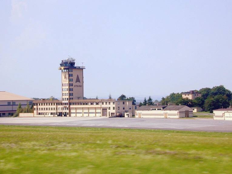
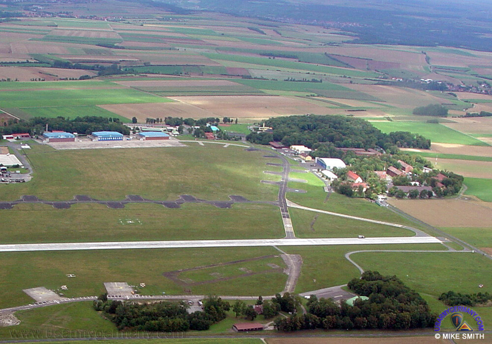
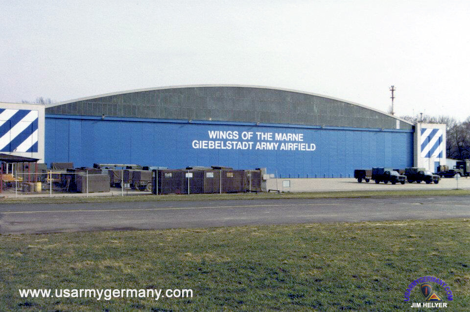
Dear Ugra @MAESTR0 Now that I’ve had a few days to go over the Germany map for DCS, it is done very well and dare I say probably the best map to release for DCS to date. It is absolutely a solid foundation for many years of fun adventures to come. I can't wait to see what kind of official campaigns come from this. With that said, I do have some constructive criticisms. The airbases all look the same and have very little character. The overuse the same generic hangars and buildings over and over is disappointing. I hope that future updates may bring a little more life to the individual characteristics of each base. Also, brought up a many times now here, the brown patches in the grass at EVERY airfield are overly exagerated. I get the vibe that UGRA media went for a late 1970’s timeframe. The color scheme they used for the NATO bases give a run down rusty vibe, which works for the Eastern Bloc bases, but not NATO. Generally speaking, US Facilities but more than likely all NATO associated facilities have pretty well kept grounds. Missing patches of grass happen, but not very often. We mow our grass, and most bases would be considered "Well Kept Garden" like. My suggestion would be to all but remove the brown patches from the airbases of the West Germany side of the map. Doing this would give us the immediate recognition of which side we are on. Similarly to how film directors use subtle light and color pallets to differentiate scenes for movie goers. As far as the Buildings and Hangars go, I recognize that compromises have to be made to optimize the gameplay and keep download sizes reasonable. One thing that could help is to close up some of the Hangars and Hass Shelters. If you get rid of some of the interiors of these buildings, then that gives a little more head room for custom details at a few choice bases. A couple examples that I explored are Bitburg Airbase, and Giebelstadt Army Air Field. Bitburg Wishlist: Personally, I would prefer to see the base with the Tan and Brown painted buildings, The HAS Shelters in the Green scheme. Minimize the brown missing grass patches. Add a custom Roether Memorial Alert shelter, add the missing weapons bunkers For Giebelstadt AAF, Generic Hangars are re-used here again, and this is an acceptable compromise (even though the real live Hangars would bring so much Character to the base). Unfortunately, the use of large light poles everywhere is not conducive to helicopter operations. Also in your rendition there are a few prominent trees in the midfield that were never there real world. Wishlist: is to "Green up the brown patches in the grass once again, Remove the light poles, and remove the trees. Every picture I have found of the hangars had the doors closed. I know its a ton of work, but with the removal of the extra polygons for the Tree and Light poles, in combination with more simple closed up custom hangars could potentially yield no frame loss, and potentially not much more hard drive space. See Below for examples of Giebelstadt. To wrap up this lengthy post. Thank you UGRA. You have done an outstanding job, and I look forward to all that you will give to us in the future. I Know that every base can't be a custom masterpiece, its just not feasible. Maybe something like picking the top 5 most well known and documented airbases, and detailing them out with more custom buildings as "Flagship" fields could be the answer. Or instead of top 5, maybe the bases that align best with the actual DCS Aircraft IE: the New Eagle Dynamics F-15C main home will be Bitburg, Hahn for the F-16, or a Belgian F-16 base maybe, ETC. Thank you for this amazing WIP map. -Preston
4 points
-
Hi all, with the upcoming CW Germany map I wonder if it is possible to convert a complete air base (or at least parts or objects of it...) into the DCS world. I did develop RAF Brüggen representing the cold war era for the flightsim P3D and would provide it for use in DCS. This would go really well together. Please let me know.
3 points
-
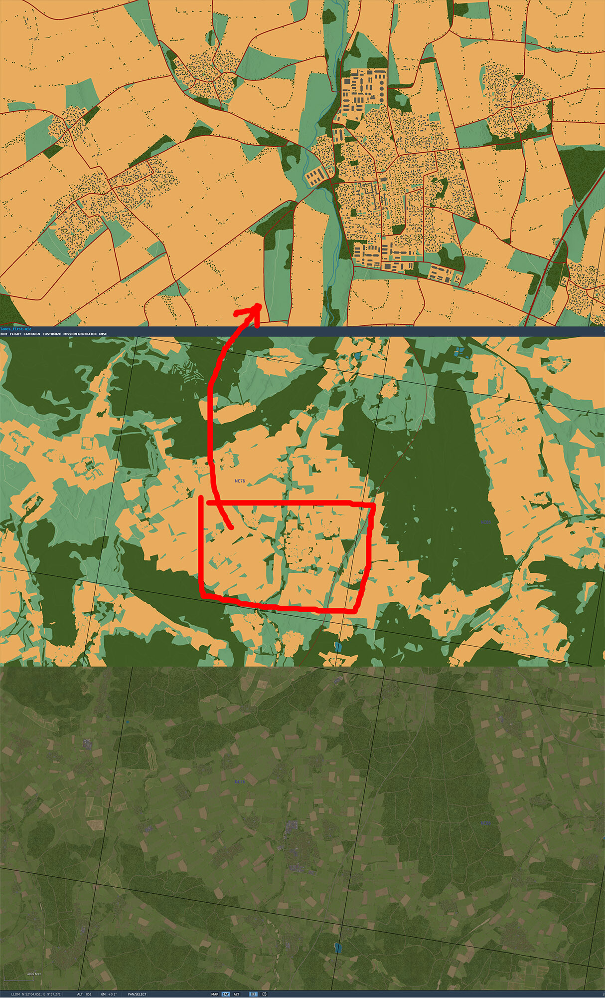
1 - on F10 map there are orange textures showing the town areas but on CWG map it's showing "high resolution textures". So just looking at the map I have an impression there are a lot of buildings in the area but when I scroll-in it's not like that. Would be better if the orange background is really showing the town/cities areas while high res fields are just green texture. (SAT view is way better to judge that) 2 - also the texture is solid and it's blocking the elevation isolines. Would be better if they are maybe 30-50% transparent null
3 points
-
because some of it is undeserved? Some people want a perfect moon for 55 bucks3 points
-
Hoffentlich fliesst er dann irgendwann mal auch in DCS bis Rotterdam. Momentan versickert er bei Remagen im Nichts3 points
-
Hi and thank you yes very quickly, just a small problem with my brother's computer to fix and it will go away. E&P3 points
-
Да какого вкуса, что на нормандии, что на новой карте цвет слишком ядреный, и это еще мягко сказано3 points
-
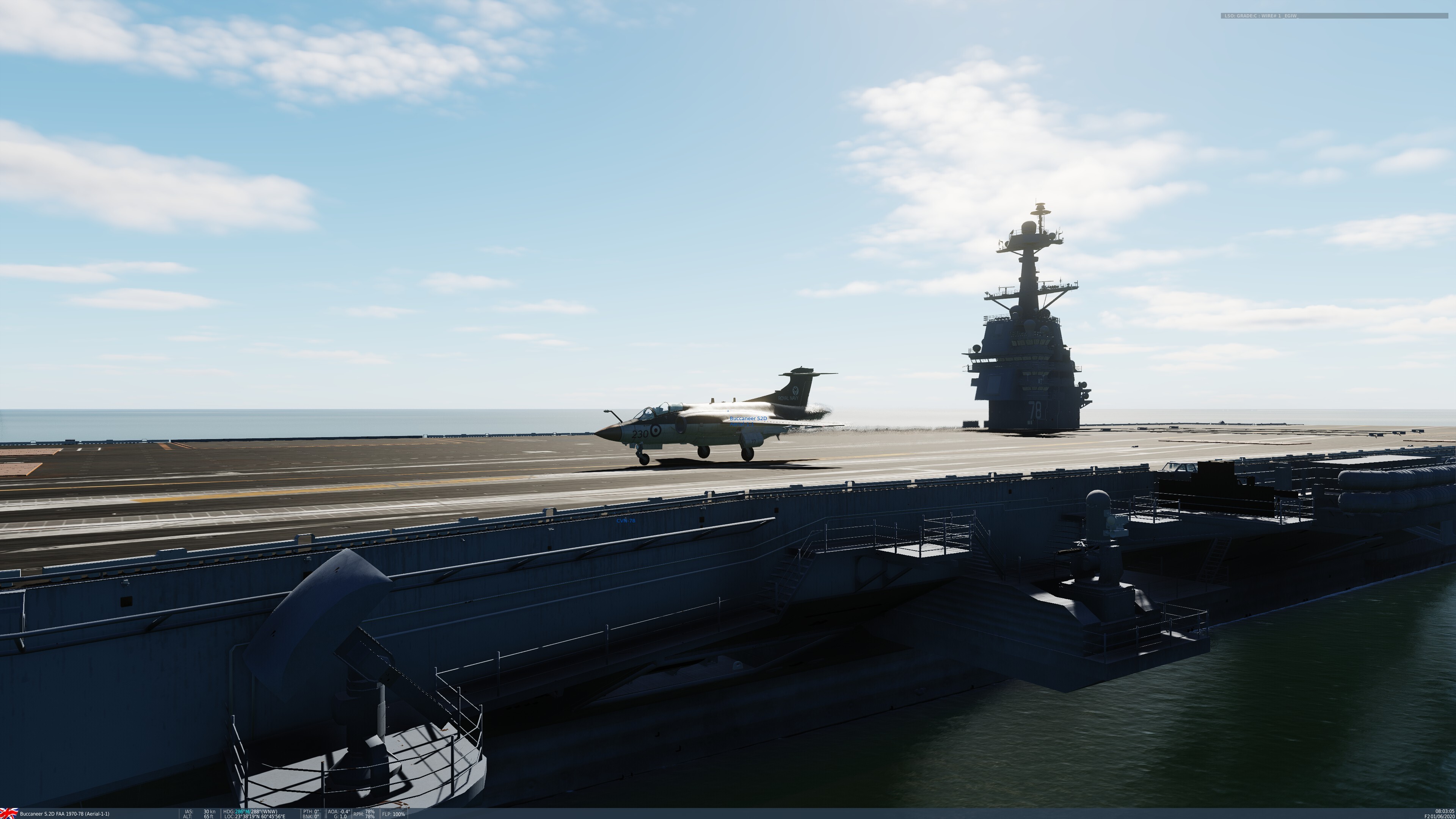
I ran a quick landing test and got some strange results. The stock F-18Cmod20 turned on final then "waved off" for no reason. Having not seen that before I tried a Mod aircraft and it landed fine????? It's possible my F-18 is messed up after I botched up restoring the Superbug mod after updating, lol but I'll post an updated Ford soon and make sure landing at least 8 planes is working.
3 points
-
Late reply as I already fixed the problem. But it was not black. It was super dark. If you ACTUALLY look you can see my camo pattern. I have been doing Liveries for nearly 2 decades now, I am not a novice. When DCS doesn't recognize the file, it DOES NOT come out black, it comes out in a Pixelated Camo color. Also, 4096x4096 doesn't mean anything. Don't give that advice out, it is misleading. 1024x1024 works, so does 2048x2048, as does 4096x4096, and even 8192x8192. Thank for trying to help though.3 points
-
https://www.digitalcombatsimulator.com/en/news/changelog/release/2.9.15.9599/ DCS Core CTD with IR missiles launch at F-86 and L-39 fixed DCS: Data Transfer Cartridge (DTC) by Eagle Dynamics Fixed: Crash when F/A-18 CMDS set to AUTO after using custom DTC CMDS threat tables. Initial improvement based on user feedback: Moved DTC panel upper (ME). Moved current cartridge combolist and partition combolist to one vertical line (ME). Moved DTC panel upper (Sim). DCS: F-16C Viper by Eaglе Dynamics Fixed: DTE category labels should clear after loading. Fixed: Crash F16C.dl.3 points
-
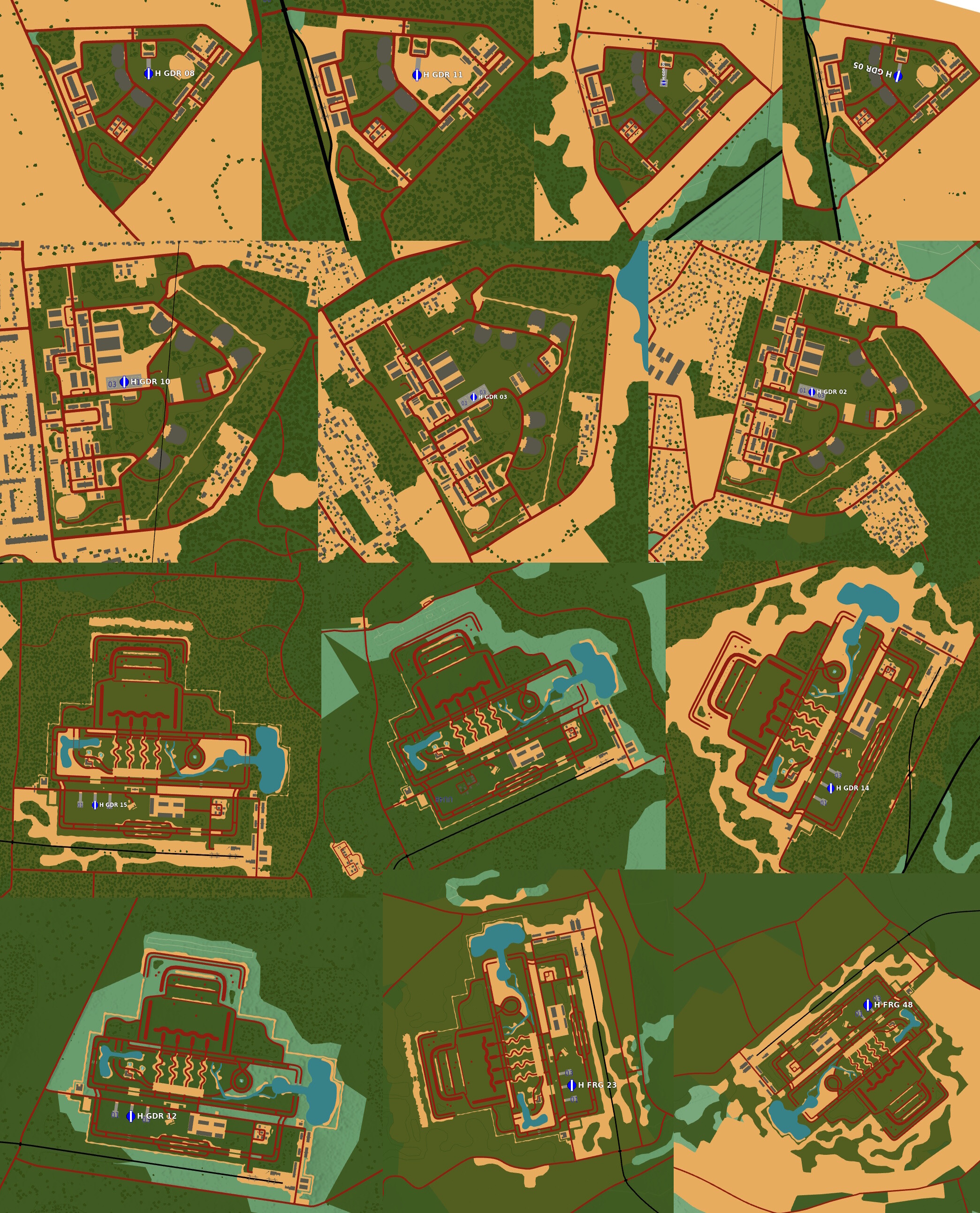
I understand that we can't expect a map of this size being entirely handcrafted. I also don't see an issue alike "too few" points of interest being modeled. I totally get that the creation of such an enormous map size will require some shortcuts, and templates might be an acceptable thing. Yet for some reason I struggle to not feeling annoyed by such widespread copy pasting of quite the big templates here. We all value Ugra for their invention of details, of raising the standards for map fidelity and inventing new ideas. Yet this slowly starts to feels like an attempt to use the incredible details on stuff like oil barrels, wall clocks, drawer handles and chairs and monitors in airfield towers, combined harvesters, blue bicycles and hot air balloons to distract us from quite the repetitive use of templates of so far unseen size. Or in other words, at this point I can't follow why it was deemed necessary to create beautifully detailed interiors of factories and power plants (for any other purpose than nice teasing pictures building up hype and the wow effect when visiting these ingame for the first and second time) while the effort would rather have been a better investment for adding some more building archetypes or increased support for the AI or whatever procedure was used to interpret all the data required for map creation. Yes, this is early access and I am already happily contributing hints and advise in this forum, to support Ugra and their product. Yet right now I wish they would have focused on those details responsible for an historically accurate depiction of things which are supposed to make this map a cold war themed map. Adding the Iron curtain and selected models of renown historic landmarks are a good basis. Its sad to see this immersion reduced by dropping ever the same templates of actually big complexes (as beautifully detailed as they may be) across the map. This is a small compilation. There are many more of these out there. Each of them is as big as several city blocks or a little village. While alone they look beautiful in their detail, the copy pasting has gotten out of control.
2 points
-
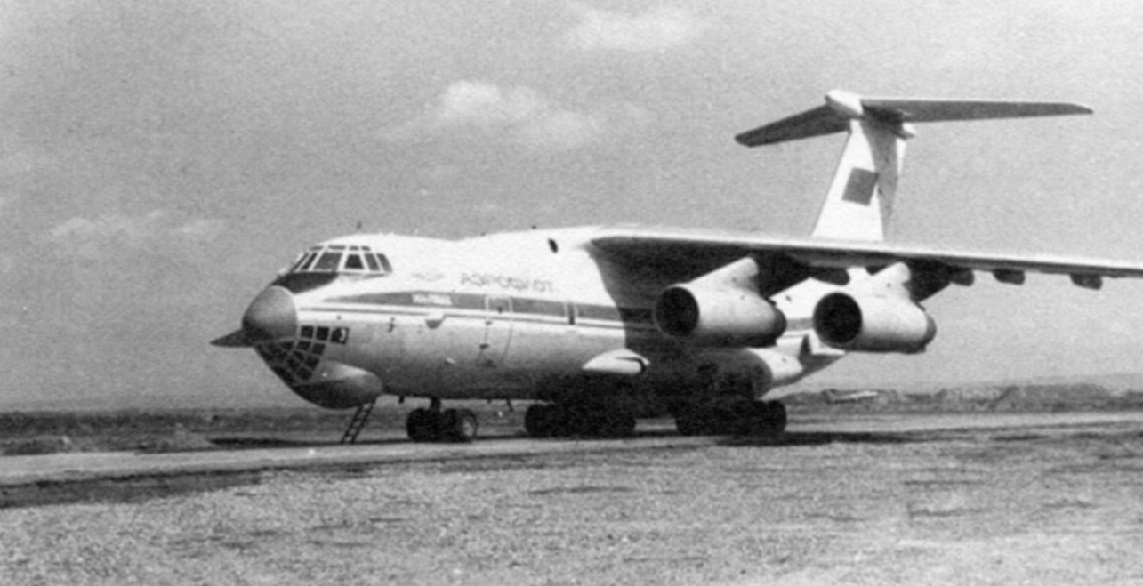
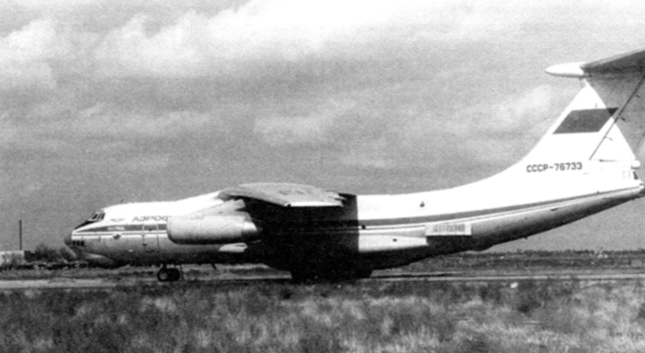
The Afghan epic of the Il-76 IL-76MD USSR-86740 lands at one of the southern airfields The Il-76 was one of the main "characters" in the introduction of troops into Afghanistan. Full-scale preparations for the upcoming operation began in mid-December. The main group of the 40th Army being formed was staffed by the Turkestan and Central Asian military districts, but the paratroopers were to carry out the first, most important, throw to occupy the most important objects in Kabul and other centers of the country. During the introduction of troops on December 25-27, 1979, VTA aircraft transferred the advanced forces of the 103rd Guards Airborne Division and the 345th Separate Parachute Regiment to Afghan airfields. The first plane with paratroopers took off on December 25 at 15:00 Moscow time (18:00 local time, when it was already dark). At 16:15 the aircraft landed in Kabul, and the last scheduled flight was completed at 14:30 on December 27, although individual flights continued to be carried out later, this time with the purpose of supplying the delivered troops and evacuating the injured. During the 47-hour operation, transport aircraft carried out 343 flights, including 76 Il-76s. In less than two days, 770 people, 894 units of equipment and 1,062 tons of various cargo were delivered to Kabul and Bagram. The tasks were completed with minimal losses. And yet, the transport operation was not without casualties - in its very first hours, an Il-76 from the 128th VTAP was lost in a crash. The loss occurred less than a month after the first Vitebsk crash involving an aircraft of this type, but this time in combat conditions, which is why it was initially considered likely that it was hit by enemy fire. On December 25, 1979, Captain V.V. Golovchin's plane was flying with vehicles and 34 paratroopers on board in another group of transport aircraft. At night and in difficult weather conditions, the plane crashed into a mountain near the Salang Pass on the approach to Kabul. Parts of the plane and flight recorders ended up in deep snow on both sides of the mountain range, and it was impossible to evacuate them from there. However, with the introduction of troops, the long and difficult work of the Military Transport Aviation in Afghanistan was only just beginning. In the winter of 1980, the 40th Army continued to be staffed with newly arriving units and provided with everything they needed - from equipment and ammunition to fuel and food. In addition, the winter that year was frosty and snowy, the roads through the passes became impassable and were constantly closed due to snowfalls and icing. This meant an even greater burden on the transporters who carried everything, since the command had set the task - the army's vital functions should be fully provided for by its own forces, without any recourse to local resources (and there was nothing to take there, even the Afghan army itself was increasingly fed by Soviet aid). The work during this period was carried out by a group of five or six Il-76s, which received cargo at the airfields of the TurkVO and delivered it to Afghanistan (and, of course, by local An-12 and An-26 from the Fergana and Tashkent air regiments). Of the Afghan airfields, of which there were 17 in the country, the "Seventy-sixths" landed only in Kabul, Shindand and Kandahar, which had normal "concrete" of an acceptable class and, what is no less important, a favorable approach scheme. Other airfields were mostly dirt or gravel, barely allowing for the work of lighter transport aircraft (An-12 and An-26), and the Il-76 base in Bagram was not used due to the proximity of mountains, which complicated the landing maneuver for a heavy aircraft, and the "Green Zone" approaching the airfield, from where shelling was frequent. During the entire Afghan campaign, Il-76 landings in Bagram could be counted on the fingers of one hand, and usually for some extraordinary reason. Usually, cargo for units stationed in Bagram, where the garrison was larger than in Kabul, was delivered to Kabul, and from there it was transferred to its destination by convoys or planes of the local 50th Air Regiment. When the flow of cargo increased, the Tashkent transport hub became like a "bottleneck". The capacity was limited by the lack of parking places, difficulties with refueling and preparing numerous aircraft. To relieve it, other border airfields of the TurkVO were used, mainly Fergana, Mary, Karshi and Kokayty. The last airfield, located near a small village on the edge of the desert, was the closest to the Afghan border, located some 30 km from it. In accordance with the increase in the scale of military operations, the workload of the military transport aviation increased from year to year. With the participation of the crews of the 196th regiment alone, 430 aircraft sorties were carried out in Afghanistan in 1983, transporting 3,496 tons of cargo and 16,238 people. The following year, 1984, 534 aircraft sorties were carried out, delivering 4,690 tons of cargo and 11,589 people. This year, the fighting army undertook a number of major operations aimed at defeating the “counter-revolutionary forces” - 51 of them were carried out in the first half of the year alone, including the famous Panjshir operation to eliminate Ahmad Shah Massoud’s formations and “strengthen the people’s authorities" on the ground. Since the Il-76 had a much better speed, altitude and rate of climb, this made it a safer means of transport, and the presence of a sealed and heated cargo cabin favorably distinguished it from the Spartan conditions of the An-12. The final argument in favor of the Il-76 was the modifications carried out with the installation of jamming blocks and an inert gas system, which significantly reduced the vulnerability of the aircraft. Since 1986, taking into account the greater safety and security provided by the Il-76, all air transportation of personnel to the DRA and home began to be carried out only on these aircraft, which is why for the majority of those who fought in Afghanistan and returned to their homeland, it was the most welcome machine. As a result, out of 880 thousand people transported during the years of the Afghan war by military transport aircraft, 780 thousand (89%) were transported with the help of the Il-76. It is not surprising that for most of the "Afghans" both the meeting with Afghanistan and the return home were connected with the flight on the "seventy-six". The work of the "seventy-sixes" in Afghanistan continued in the same routine manner until the last months of the war. When the deadline for the final withdrawal of troops approached, the volume of work for the transporters increased significantly. The VTA coped with the task. The last unit of the 40th Army left Kabul on February 4, 1989. The remaining small forces from the 103rd Airborne Division were tasked with protecting the Kabul airport, where transport planes continued to fly. They left Afghanistan on February 14 with the last group of military personnel, advisers and diplomatic workers. In total, during the Afghan war, VTA planes carried out 26,900 sorties in Afghanistan, transporting 880 thousand people and 426 thousand tons of various cargo. Of this number, the Il-76 accounted for 14,700 sorties (54.6% of the total, or slightly more than half), but they delivered 89% of all personnel and 74% of cargo - more than indicative figures, especially considering the almost one and a half year break in 1984-1985, which required modifications to the aircraft's protection. After the fall of the Najibullah government in April 1992, a decision was made to evacuate the Russian embassy staff from Kabul. Along with Russian citizens, diplomats from India, China, Indonesia and Mongolia, a total of more than 150 people, were to leave Afghanistan. Three Il-76s from the 110th VTAP with the crews of regiment commander Colonel E. Zelenov, political officer Lieutenant Colonel A. Kopyrkin and Major V. Malov were sent to evacuate the people. On the evening of August 27, 1992, they landed at the Kokayty airfield. According to the plan, at dawn the next day, the group was supposed to fly to Kabul, with cover provided by two dozen paratroopers on board the planes. After loading people, diplomatic cargo, and the bodies of two dead Russian citizens at the Kabul airport, the Il-76 of the lead E. Zelenov took off and headed home. At that time, the mujahideen, attracted by the excitement at the airfield, began a rocket attack. Nevertheless, the second Il-76 of Lieutenant Colonel A. Kopyrkin managed to complete loading and began taxiing for takeoff. There were still 56 people at the parking lot, along with Ambassador E. Ostrovenko and his wife, heading for Major Malov's plane. Another rocket hit the wing of the Il-76 and the plane caught fire. The pilots and paratroopers began to jump out of the burning machine, ready to explode at any moment, running around the parking lot. The crew of A. Kopyrkin's plane, which had already taken off, saw the Il-76 burning in the parking lot, stopped taking off and, turning around, taxied to the rescue of their comrades. Under incessant shelling, he picked up Malov's crew, the paratroopers and some of the passengers who had managed to run up to the plane. Another explosion near the Il-76 pierced several of its wheels with shrapnel, but the crew managed to taxi onto the runway and lift the heavy machine into the air. The landing in Kokayty had to be done "barefoot", with the rumble of brake drums on the concrete, but the hardy Il withstood this test too. IL-76MD at the airport in Kokayty. The border airfield often served as a trans-shipment base for the delivery of goods to Afghanistan. The aircraft is equipped with blocks with heat traps in the rear of the fuselage. The aircraft technician escorts the Il-76 that is taking off. Airfield Tashkent-Vostochny, April 1987 From the book "Il-76. Hero of Kandahar" by Viktor Yuryevich Markovsky
2 points
-
I agree - for me the trees and the grass is way to green2 points
-
I have not seen the map yet, nor do I have any clue about the era this map is meant to address. Despite actually being from the area I might add. I just want to say that I don't think the OP is coming across as "nit picking" at all. And I hope that the devs at least consider, what I believe is, this absolutely legitimate feedback. Coming from someone who actually knows the context of the time and area. I find it more than resonable to address aspects of a product which align with its sales pitch.2 points
-
Weil genau dort der erste Spawnslot ist. Siehe Handbuch: Und wenn du dort kein statisches Objekt hinparkst, wirst du eben genau in diesem Slot gespawnt.
2 points
-
Another new testing video2 points
-
Your developping skills are impressive! Regarding the gates: You are right. There are 2 gates with guard posts and barriers, then 4 more crash gates. Gate 6 had a bridge in front, especially built for fire cars because of no other way to the south west side. This bridge was used for decades by spotters for impressive shots. If you need more informations, please let me know, because the RAF Gütersloh era was used by several squadrons, regarding this the buildings and objects did change in the 70s, 80s and 90s....For example in the Lightning era (70s) there still were no HAS, just built with the Harriers arrival late 70s/beginning 80s. Same with the big maintenance hangar to the west side. Just constructed with the arrival of the CH-47. Then 1993 the Harriers left Gütersloh towards Laarbruch and the west section was used by Westland Lynx and Gazelles while the base was renamed to Princess Royal Barracks. Just memories, no Wikipedia, but there are many other important informations. As you see there are many different useable eras during the cold war, but in my opinion, the 70s or 80s are the most dangerous years and probably should be considered.
2 points
-
You are correct on the rest but not on this. If the texture is missing from either the folder or that the description.lua it will come out with the green pixel camo pattern. Thats why the green texture has the words "missing texture" all over it. However, if for whatever reason your texture file is not one that DCS recognizes even though it is brought up in the description.lua properly it will come out completely black. Try for yourself, make a texture that is 4096x4099 and call it per usual in your lua file it will turn out black. Just because you've never come across something doesn't mean that it doesn't exist or that it's wrong. Maybe after you try it out and see for yourself what I'm talking about you'll understand why I made the assumptions I did. Actually here, let me show you: I made the external 1 diff texture 4096x4099 which is a pure white dds. Comes out black. Almost like I was right... at least about that. I pointed out that it needed to be 4096x4096 because as a general rule, that is the size DCS textures normally are. You are correct that even 8192x8192 works as well as all those other sizes. If there is camo in your screenshot, apologies for not realizing that I needed to zoom into your 1000x678 pixel image which takes up less than a quarter of my screen to notice what might or might not be camo. Also apologies that I made assumptions about you and your knowledge, and I will completely eat that, I should not have worded it that way without doing a thorough background check.2 points
-
Now with the Cold War Germany map published it would be great to have a full fidelity A-10A for the 1980s, as the A-10C program started as late as 2005. Should be even easier to realize than the MiG-29 and F-15C, because it is only a downgrade from the A-10C.2 points
-
I think Ugra are far from being anywhere remotely "lazy". However, accuracy is something that's quite important to me and it's something most DCS maps fail quite badly on, especially when it comes to sites I will be interacting with and sites that either influence air combat or are significant targets. Do I care about getting every building correct, absolutely not - I personally couldn't care less that some building in some village or town isn't 1:1 with the real place, so long as the layout of the place is accurate and the buildings are roughly the right size, I don't really care if it's copied and pasted throughout the map. Of course some variety would be nice, but I'm perfectly happy if villages and towns had purely generic, copied and pasted buildings. The only exceptions I'd make are prominent buildings and landmarks, especially those clearly distinguishable from the air, though Ugra has already done a pretty fantastic job of that already. Airbases though? I'm expecting those to be as 1:1 as possible, even if assets are repeated where they make sense. Gütersloh for instance has the wrong shelters, there's no ramparts/revetments in parking areas near shelters, the Ems is in the wrong place etc. Then there's fields like Beinenfarm, which looks almost nothing like how it really does. I am not a fan of the dug up look airbases have though and no it doesn't look like dry grass, especially when you compare to the surrounding green grass. The Germany map also has the same issue when it comes to airbase warehouses, with ammunition particularly being quite bad - with warehouses assigned to seemingly random objects instead of the actual WSAs present (and modelled, at least in some cases). Similarly for other military installations, these I'm expecting to be as 1:1 as possible, especially air defence sites (with exceptions where it makes sense - SA-2 sites for instance follow a very similar layout for each site - there it makes perfect sense for them to be copied and pasted). Ugra seems to have done well (SA-3 site for instance looks pretty much perfect for that particularly layout, it would be nice to get another but more than happy with it as-is), much better than most maps (apart from Sinai and a tad of Syria, the bar is on the floor though) - but there's still loads missing, the HAWK and SA-5 sites are inaccurate and in some cases fictional tank ranges have been placed, while real military sites in the vicinity are omitted (ironically what should be a forest has one of the tank ranges in it, meanwhile 2 SA-3 sites and an EWR site in the vicinity are omitted and replaced by trees). I so far haven't seen major tank ranges like the Altmark range just north of Magdeburg and Grafenwöhr - the current tank range objects look like neither and it'll be disappointing if they're just placed where those 2 ranges are, especially given how prominent these sites are. For static aircraft, tanks etc and other similar scenery objects - those I'd rather be actual assets I can interact with, they'd be much more useful as functional units, than they would as static scenery objects, which are only good for eye-candy alone. The Aist we saw for instance is armed and would go well into fleshing out Soviet amphibious units, alongside the Ropucha.2 points
-
This is a bug, we will look at the issue and see what can be done. thank you for highlighting it2 points
-
Hast du auch den Objektmodus aktiviert? (Das kleine Panzersymbol unten rechts in der Statusleiste) So sollte das dann aussehen: Quelle:
2 points
-
Nice the ARDU F111C is just a few suburbs away from me at the Port Adelaide Aviation Museum!!2 points
-
Einfach links die Brücke (Statische Objekte) anklicken und direkt auf den Träger platzieren. Als Attribut verbindest du es dann mit dem Träger "Verbunden mit" steht da glaube gerade aus dem Kopf heraus dran. Die Objekte die nicht gehen werden dir direkt sagen dass sie nicht auf dem Meer platzierbar sind. Funfact, Maritimie Lufteinheiten wie der SH60 Helikopter werden dann direkt mit eingeklappten Rotoren dargestellt.2 points
-
This is a great reference source if you can get a hold of a copy... Lots of info and useful sketches.
2 points
-
Okay, let's stick with English... Yes, you're right! I unfortunately overlooked the clock you described, as I've never used DCS in 15 years... Someone had pointed me to the "Historic button," but I couldn't find it. Now I can use it to switch between aircraft groups up to 1999 or unlimited. However, I can see the AH-64D and the F16C in both time periods. Thank you for the quick clarification!2 points
-
Поставил текстуры на средние, добавил фильтр, и вполне себе колдварно выглядит, и без лагов))
2 points
-
I've released 1.4.1, fixing a regression in cloud speech recognition: https://github.com/dharmab/skyeye/releases/tag/v1.4.12 points
-
Вполне себе кислотненько. Нормальная зелень на картах, как в реале - гамму крутите на своих мониторах да и всё, есть же к тому же цветокоррекция в настройках. А то это все такое мол не такой красный нам нужен, а какой? Нам ПРОДАЮЩИЙ красный нужен! Ну здесь у Югры видать зелёный продающий.2 points
-
Ну в 500 м над Тверью не удалось посмотреть, а вот с моста сегодня ехамши, специально окинул общий план, и вполне себе всё ярко-зелёное, салатовое, я бы даже сказал в желтизну отдаёт. Особенно под солнечными лучами. Сейчас конечно весна, а не лето, но на данный момент вижу так.2 points
-
@MBot Thanks for the info, the shelters will be stronger.2 points
-
The trees are the real problem. What are the trees supposed to do inside the death strip? Assist fugitives when climbing across the wall? Also there was generally no grass. It should be all sand. Border guards wanted to see any kind of traces from people attempting to reach the wall on foot.2 points
-
If I am recalling correctly from previous discussions on this topic they are friction fit and pulled out similar to keycaps and lose their retention from being pulled out and put back in over time. Bonus image of VF-33 jet with the wire during Desert Storm2 points
-
Would be nice... to set the Operation Storm-3332 points
-
Something's coming our way...Your campaigns are simply amazing! A campaign from you on the Mi-24P or FF Mig-29...would be fantastic.2 points
-
Thank you KarlRadek for pointing this out and providing so much detailed information! When modelling coal mines in more detail, please also include the lignite mining areas west and north-west of Cologne which has hosted vast coal mines during the cold war and up to this day: Rheinisches Braunkohlerevier (Wikipedia) Rheinisches Braunkohlenrevier - - Flächennutzung um 1980 (Diercke) Rheinisches Braunkohlenrevier - - Flächennutzung um 1980 - Nordrhein-Westfalen - Rheinisches Braunkohlenrevier - Landschaftswandel durch Bergbau. Source: Diercke These areas are already visible in the surface textures of the sim, so I hope detailed terrain mesh, 3D objects and structures will be added in the upcoming phase 2 or 3, as they are major landmarks typical for the region. Kudos, deep appreciation and gratitude to the developers, and please do keep up the great work!2 points
-
Hello there, Is there any April news/updates on the F1M? Friend of mine was about to purchase de M2000C to join me but, well you know... I mainly fly M2k, F1 and sometimes A10 or 16 but I'm really looking forward to have something a little more modern so is my friend (he's not into CW) when it comes to the F1. Are they planning on releasing the 104 1st and then get back to the F1M? Should we expect it soon, late 25, next year? Not discussing the "better late and ready than early and incomplete" just trying to understand where they are and what we could expect in the near future Q2 Q3.2 points
-
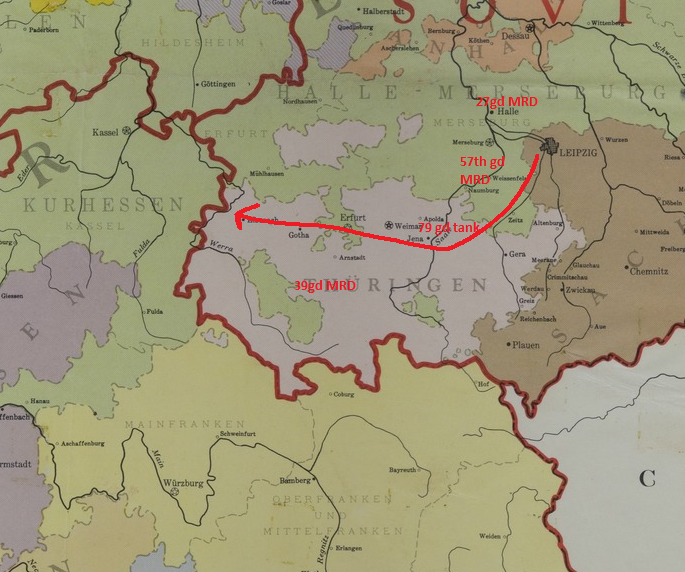
Hey all. I've been sticking my nose in a whole slew of manuals, pamphlets, and papers to channel the spirit of 1981, and I thought Id share a hopefully inspiring example of the sort of missions you might realistically fly. First, to set the stage: June 12th, 1981. McPheeters Barracks, Bad Hersfeld, Germany. The troops of the 11th Armored Cavalry Regiment are scrambling to get to their equipment. Somewhere up north along the border a single shot turned into a skirmish and then into a war. Neither side seems to have been mobilized, and no nuclear weapons have been deployed yet. But even without weapons of mass destruction, the 8th Guards Combined Arms Army across the border is a formidable force. The closest group to the border, the 39th Guards Motor Rifle division alone has over a hundred tanks and over half a thousand BMPs. As the troops get ready for battle the first jets loaded with bombs fly past low and fast. Air-land battle and you: what is the job of aviation? NATO does not want to trade space for time. After all, space is inhabited by the very people they are trying to protect. NATO therefore needs a plan to win battles right at the border. In March 1981 the US Army Training and Doctrine command published an 84 page pamphlet outlining the Airland battle doctrine that would be developed further in field manuals in 1982 and 1986. At its core, this means fighting the enemy on the ground and in the air at the same time. It asks commanders to fight not only the enemy directly in front of them, but also the second echelon forces following behind, still in enemy territory. The Warsaw pact intends to win by applying constant pressure across the entire line until it breaks (it is, of course, greatly oversimplifying things to boil it down to a single sentence. But I'm doing so anyway). The goal of fighting the second echelon is to relieve this pressure and allowing American troops to seize the initiative and act, so they can reposition, counterattack, resupply, whatever the situation may demand. To boil the counter-strategy down to a single sound-bite as well, the plan is to trade firepower for time. Later in the decade, new weapon systems like the M270 MLRS and AH-64 Apache will offer commanders better weapons of their own to engage the second echelon. But for now, nearly all of the interdiction will have to be provided by the Air Force. Since at least 1943 interdiction - hindering the movement of enemy troops not currently in contact - has been identified as an important part of air power. It was less important than air superiority, but more important than Close Air Support (CAS.) V Corps, the American unit responsible for the “Fulda Gap” has a staff unit dedicated to the interdiction mission. Their job is to analyze in real time which routes the enemy will take and how long it will take them, and to use strike aircraft, helicopters, artillery, and electronic warfare to delay and disrupt them as much as possible. This is where we come in. It should be noted that missions are going to be flown against planned targets. The objectives are going to fit into three categories: Delay the enemy by a given amount of time. This is unfortunately somewhat hard to measure in DCS. Channel the enemy down a specific route. Also on the face of it not possible in DCS because the ground units just follow their waypoints. Defeat the enemy in a specific area. This one we can at least measure in DCS. The good news is, its not up to the fighter jockey to judge the success, so at the end of a flight we can still get a nice mission success screen. As a final note, interdiction missions are going to be against planned targets. Between the thousands of anti aircraft weapons on the ground and the thousands of aircraft in the sky, there's not a lot of room to fly around looking for targets. Leave finding targets to the OV-10s and other reconnaissance aircraft. This map shows the locations of the divisions of the 8th GCAA and a big red arrow along their path to the border. If V corps determines that these troops are indeed headed for the Fulda Gap, and not towards Bamberg in the south, they are going to want to focus their efforts on delaying all enemy units that might join the battle in the next 72 hours, up to a depth of about 150 kilometers behind the front line. There is a highway that runs all the way from Leipzich past Jena, Weimar, and Erfurt to the border. This is the fastest route for the enemy to get to the frontline. The goal of our strike package will be to degrade this highway to delay the next unit following it by two hours. This will give the ground troops some time, but also gives the air force another two hours to rain down ordnance on the enemy units now slowing down at chokepoints. If we look at this highway in DCS, we come across this pair of bridges at Günthersleben-Wechmar a bit South-East of Gotha. If these bridges are destroyed, Soviet forces will get delayed as they will have to repair/replace the bridge or ford the stream, none of which is as fast as driving across a bridge. Enough little delays like that add up quickly. These bridges will be the target of our flight, a 4-ship of F-4 Phantoms from Hahn Air Base with high drag bombs. Missiles, Missiles everywhere: the threats. About five kilometers North of the bridges sits an SA-2 battery at FRA-513 Seebergen bei Gotha, and 31 kilometers South-East sits another at FRA-514 Remda bei Rudolstadt. Besides these fixed East German systems, each of those four Soviet division has an SA-6 regiment with multiple batteries and each of the 4 regiments per division has 4 ZSU-23 Shilkas, 4 SA-9 or SA-13 SAM vehicles, and an awful lot of MANPADS. There are also doubtless mobile East German systems roaming around, but I think I’ve done enough research for today. And of course, the Warsaw pact has hundreds if not thousands of interceptors standing by as well. There will be a lot of aircraft wrecks by the end of the day! YGBSM: Supporting flights. Luckily our flight is not alone. At Spangdahlem Air Base sits an entire wing specialized in Wild Weasel operations. They will be out there to suppress the SAMs. F-15s from Bitburg will be providing top cover directed by E-3s from Geilenkirchen (Ugra pls ) There will be no tankers until the situation in the air has become a little clearer. Its about the journey: sights along the way. As you make your way from Hahn to the target, you will pass through the HAWK belt. This is a line of HAWK Surface to Air Missiles that run from the coast to the Austrian border. These are going to be looking for targets. Because radio communications could be jammed, simple corridors have been pre-arranged. you'll be low and fast, as will almost all aircraft. Maybe you'll see F-111s or Tornados on their way to bomb enemy airfields. Cobras or Hinds engaging enemy columns with missiles and rockets. Su-24s or Su-22s heading for the front - or your airbase. With everyone low and fast your chance to acquire, identify, and engage an enemy aircraft is going to be minimal, and turning and fighting is a great opportunity for someone else to run in and hit you with a steel chair. On the ground below you might make out exchanges of gunfire, ATGMs flying around, hillsides getting cheese-gratered by DPICM, and vehicles turning into burning wrecks. Beyond the frontlines you might see a motor rifle battallion snaking around some abandoned civilian cars, scrambling to bring the MANPADSs to bear. Hopefully, there's no Shilka or SA-13 waiting for you at the bridge, no MiGs scrambling to intercept you, and the SAMs are nicely distracted by the wild weasels. With a bit of luck you might even make it to the end of the week That's a bit long I guess. But I hope I managed to summarize the role of USAF aviation in a cold war gone hot scenario and given you some inspiration to go make a cool mission. The pamphlet I mentioned is TRADOC Pamphlet 525-5 25 March 1981.
2 points
-
I agree with a lot of points here. But although the map needs a little more work (too much trees, city’s too small), I would buy it again. Also if the map would stay in its current state it’s worth the money.2 points
-
Personally I like the map. Its's early access so there are going to be issues. But even in this state of release it looks good.2 points
-
Unfortunately, I have to agree - mixed feelings. The first hours I liked the green map. Berlin looks great with all the famous buildings that we all know. But some geographical coverage is not correct. I know, we can not expect a map and details like in the MS Flight Simulator, but if the geopraphical quality is to rough, it is just a green map. Well, it is early access and work is in progress, so I hope things are getting fixed and sure, they will improve over time. Some points I have noticed (so far): - There are to much trees. The forest areas are too large - Hills, mountains and bridges should be correct - Cities should be recognized (at least) by there size. Some big cities have only a few houses and are looking like small villages, e.g. Wuerzburg (there are also some very nice historical buildings...) - The street lightning on highways (Autobahnen) looks great, but in Germany, we don't have this lightning. It differs to other countries like the Netherlands or Belgium - Autobahnen don't have crossroads - Autobahnen should have some cars (well, it might be a performance thing or it is just war and nobody is using the streets...) - Many graveyards in East Germany have orthodox crucifix, but only a few People there where orthodox. That is not important for me, but it seems that it was important for the map design and that's why I mention it I am looking forward for the next updates.2 points
-
DCS: Data Transfer Cartridge (DTC) by Eagle Dynamics Fixed: DTC Crash if in track restart mission, then take control and restart again. Fixed: DTC Windows Export/Import are displayed after a unit is destroyed in some cases. Fixed: DTC button in Briefing is available on dynamic spawned aircraft in MP. DCS: F/A-18C by Eagle Dynamics Fixed: Crash FA18C.dll. Fixed: Crash cockpit UHF ARC-210. DCS: F-16C Viper by Eaglе Dynamics Fixed: Radar RWS TDC bumping range and azimuth settings no longer work. DCS: AH-64D by Eagle Dynamics Fixed: LASER power button is not functioning. DCS: F-5E by Eagle Dynamics Fixed: Crash when launching missiles AIM-9B at an airplane that uses flares. Fixed: Left Wingtip (Pylon 1) missile determines if the AIM-9 provides tone or not. DCS: F-4E by Heatblur Fixed JESTER failing to Align the INS on start-up. DCS: Kola map by Orbx New: ENAT - Alta airport New: ENEV - Evenes airport New: EFET - Enontekiö arctic airport New: EFSO - Sodankylä airfield New: Airstrip Road 924 near Hosio New: Populated areas around Kuusamo airport New: Populated areas around Kallax airport New: Added missing charts for Civilian airports Fixed: A disconnected road near Borjelsbyn Fixed: Removed trees blocking aircraft taxi path from E08 parking to runway Vidsel Fixed: Added a missing bridge near Ruka Fixed: Updated runway numbers on Kittila airport Fixed: Missing PAPI added to ESPA Fixed: Changed map date for winter to start on the 15th November instead of 1st December Fixed: Optimisation first pass Fixed: Fixed model causing FPS drops at Rovaniemi2 points


-
Recently Browsing 0 members
- No registered users viewing this page.