Leaderboard
Popular Content
Showing content with the highest reputation on 03/23/24 in all areas
-
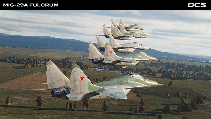
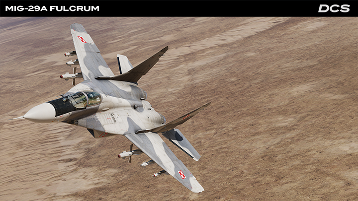
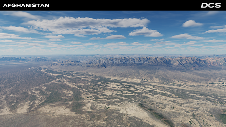
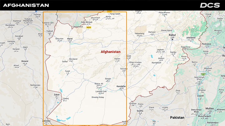
22 March 2024 Dear Fighter Pilots, Partners and Friends, It is with great excitement that we officially announce DCS: MiG-29A Fulcrum. This remarkable, Soviet Union-era fighter will be a full-fidelity module based on a photogrammetry cockpit of the exported variant supplied to the Warsaw Pact countries. The MiG-29A will be by far the most authentic and accurate simulation of this iconic aircraft for the PC. DCS: Afghanistan map by Eagle Dynamics is progressing at full throttle with significant milestones achieved since the project’s inception. The progress report below provides a good overview along with post-early access release plans. The DCS Spring Sale 2024 is in its final hours and you can still benefit from the amazing deals, until the 24th of March at 15:00 GMT. Please enjoy this opportunity to upgrade your collection of aircraft, terrains, tech packs and campaigns with up to -50% savings. Thank you for your passion and support. Yours sincerely, Eagle Dynamics MiG-29A Fulcrum Announcement Our MiG-29A, NATO codename Fulcrum, will be the export modification of the “A” version that was supplied to Warsaw Pact countries. The MiG-29A was designed to counter all types of aerial targets with radar- and infrared-guided R-27, R-73, and R-60 air-to-air missiles and its single-barreled 30mm cannon with 150 rounds of ammunition. The MiG-29A also has limited visual ground attack capability with 50 to 500 kg bombs, cluster bombs, and unguided S-5, S-8 and S-24 rockets. The MiG-29A can operate day or night and in all weather conditions. Its radar is capable of look-down / shoot-down in a heavy electronic countermeasure environment. The weapons control system consists of two complexes: the Fire Control Radar (FCR) and the Optical-Electronic Targeting Navigation System (OETNS). The OETNS includes an optical-electronic sighting system (OESS), a navigation system, a weapon control system, a unified display system, and multifunctional control panels. The OEPS includes an optical location station OLS that consists of an Infrared Search and Track System (IRST), a Laser Range Finder (LRF), and a Helmet-Mounted Sight (HMS) designation system. The MiG-29 is equipped with the SPO-15 “Beryoza” Radar Warning Receiver (RWR) defence system that is designed to warn of radar-directed weapon attacks. To protect against infrared-guided weapons, the MiG-29A features flare dispensers. The navigation system consists of on-board navigation equipment, a vertical and heading information complex, and an airborne signal system as part of the Optical-Electronic Targeting Navigation System (OETNS). Key features of the DCS module: MiG-29A Fulcrum At Early Access Release: Fully interactive and highly detailed cockpit that is based on 3D laser scanning and photogrammetry. Highly detailed and accurately reproduced external model. Highly detailed pilot model. In-depth study of aircraft systems and equipment. Detailed model of the navigation system with the gyro platform reference system, air data computer, and navigation equipment. Defensive equipment to include the SPO-15LM “Beryoza” and Flare dispenser system. Fire Control Radar with authentic modes for aerial targets. OETNS with modes for air and ground targets. At Final Release: Addition of Identify Friend or Foe interrogation system. Addition of Ground Control Intercept (GCI) command system. Afghanistan Development Report The development of the DCS: Afghanistan Map is progressing on schedule with significant milestones achieved. We are committed to delivering a highly immersive and authentic representation of Afghanistan for virtual pilots to explore and engage in combat operations. Continued collaboration, testing, and refinement will ensure the map’s successful completion and release to our DCS community. Development Progress We have made substantial progress in recreating the diverse landscape of Afghanistan. This includes the rugged mountain ranges of the Hindu Kush, the vast deserts of the Dasht-e Kavir and Dasht-e Lut, and the fertile valleys and river basins. Efforts have been dedicated to accurately portraying the unique cultural and urban features of Afghanistan. This involves recreating cities like Kandahar and Herat, with special attention to landmarks, infrastructure, and architectural styles like the blue mosque of Herat. Aerial imagery has been utilised to enhance the realism and accuracy of the map. High-resolution satellite imagery is being integrated to provide authentic terrain textures and details. The diverse terrain and complex topography of Afghanistan has presented technical challenges due to the large mountainous ranges. Optimization efforts are ongoing to maintain performance without compromising on visual fidelity, particularly in densely populated urban areas and detailed terrain features. The map is designed to look equally as good from low to high altitude. Future Plans In the above screenshot, you can see the area of DCS: Afghanistan that will be available in Early Access. The airfields that will be available at launch include Kandahar, Herat, Bost, Camp Bastion, Chaghcharan, Dwyer, Farah, Maymana Zahiraddin Faryabi, Qala i Naw, Shindand, Tirinkot, and Zaranj. The focus will be on completing the detailing of terrain features, including rivers, roads, vegetation, rocks, small stones, ground clutter and geological formations to enhance immersion and realism. Extensive testing and optimization will be conducted to ensure optimal performance and compatibility with a wide range of hardware configurations. Please stay tuned for the pre-order coming soon! Spring Sale Final Hours The DCS Spring Sale 2024 is your chance to grab massive 50% savings across almost our entire range of aircraft, terrains, tech packs, campaigns and more! Please make sure that you do not miss out on this opportunity and remember the DCS Spring Sale 2024 runs until the 24th of March, 2024 at 15:00 GMT. Thank you again for your passion and support, Yours sincerely,
 11 points
 -
MiG-29A Fulcrum Announcement It is with great excitement that we officially announce DCS: MiG-29A Fulcrum. This remarkable, Soviet Union-era fighter will be a full-fidelity module based on a photogrammetry cockpit of the exported variant supplied to the Warsaw Pact countries. The MiG-29A will be by far the most authentic and accurate simulation of this iconic aircraft for the PC. Our MiG-29A, NATO codename Fulcrum, will be the export modification of the “A” version that was supplied to Warsaw Pact countries. The MiG-29A was designed to counter all types of aerial targets with radar- and infrared-guided R-27, R-73, and R-60 air-to-air missiles and its single-barreled 30mm cannon with 150 rounds of ammunition. The MiG-29A also has limited visual ground attack capability with 50 to 500 kg bombs, cluster bombs, and unguided S-5, S-8 and S-24 rockets. The MiG-29A can operate day or night and in all weather conditions. Its radar is capable of look-down / shoot-down in a heavy electronic countermeasure environment. The weapons control system consists of two complexes: the Fire Control Radar (FCR) and the Optical-Electronic Targeting Navigation System (OETNS). The OETNS includes an optical-electronic sighting system (OESS), a navigation system, a weapon control system, a unified display system, and multifunctional control panels. The OEPS includes an optical location station OLS that consists of an Infrared Search and Track System (IRST), a Laser Range Finder (LRF), and a Helmet-Mounted Sight (HMS) designation system. The MiG-29 is equipped with the SPO-15 “Beryoza” Radar Warning Receiver (RWR) defence system that is designed to warn of radar-directed weapon attacks. To protect against infrared-guided weapons, the MiG-29A features flare dispensers. The navigation system consists of on-board navigation equipment, a vertical and heading information complex, and an airborne signal system as part of the Optical-Electronic Targeting Navigation System (OETNS). Key features of the DCS module: MiG-29A Fulcrum At Early Access Release: Fully interactive and highly detailed cockpit that is based on 3D laser scanning and photogrammetry. Highly detailed and accurately reproduced external model. Highly detailed pilot model. In-depth study of aircraft systems and equipment. Detailed model of the navigation system with the gyro platform reference system, air data computer, and navigation equipment. Defensive equipment to include the SPO-15LM “Beryoza” and Flare dispenser system. Fire Control Radar with authentic modes for aerial targets. OETNS with modes for air and ground targets. Basic IFF At Final Release: Addition more advanced Identify Friend or Foe interrogation system. Addition of Ground Control Intercept (GCI) command system. Source: https://www.digitalcombatsimulator.com/en/news/newsletters/8a53b9baafb8473116ad05970cd8a761/ Info on the PFM used from the FC3 version: Full-fidelity MiG-29 will use the same flight model. Actually, that’s not 100% accurate. The autopilot will receive new functionality and modes, and certain issues with closed-loop system stability will be corrected, along with new undercarriage characteristics. But the core FM is probably one of the most accurate we have. IFF Info: On release of the MiG-29A, it will include a basic IFF system, later on after some RnD we will create a more advanced IFF system. This was the plan from the start, it was just lost in drawing up the newsletter, we apologize for any concerns it might have caused. Thanks!9 points
-
Afganistan Develop Pics.9 points
-
Heatblur update F-4E7 points
-
Because most prefer to have something early to play with. If early access is not for you please wait, if you support us in early access or wait for full release we are grateful for the support.6 points
-
finished the generic 7./jg26 texture and made a color variant for the squadron leader. Brown 7 is the last unique dora of 7./JG26 im gonna do.
6 points
-
The new header means exactly nothing for the release of the Phantom. You‘re literally chasing phantoms now….. Why do people always want to read into anything? Is this how astrology came around?5 points
-
We will do the entire country, I have asked for more info about further details.5 points
-
Sadly it seems you are trying to find negativity in this announcement, I do not understand the point you are trying to make here. First I have played hundreds upon hundreds of missions on the Caucasus map with Blue and Red aircraft and enjoyed my time there. I am not sure what your rules are towards "semi-convincing/plausible mission" but I have never flown one and said, boy this is unrealistic and I am not having fun aside from the fact I am sitting in my house on a computer. So if you are saying you cannot make mission on a map that are not fun based on them having to be plausible then I think you not letting your imagination flow. The same goes with the Early Access portion of Afghanistan, you will be able to see up what I consider to be at the very least "semi-convincing/plausible mission" such as COIN but why limit yourself... draw a line in the sand, put red on one side and blue on the other and create a story and just have fun, like every other map in DCS. I think some are just overthinking this waaaaay too much, but also this is not a mandatory purchase if it isn't your thing then we understand like any of our modules while we appreciate every purchase we understand not every one is for everyone.5 points
-
Afghanistan Development Report The development of the DCS: Afghanistan Map is progressing on schedule with significant milestones achieved. We are committed to delivering a highly immersive and authentic representation of Afghanistan for virtual pilots to explore and engage in combat operations. Continued collaboration, testing, and refinement will ensure the map’s successful completion and release to our DCS community. Development Progress We have made substantial progress in recreating the diverse landscape of Afghanistan. This includes the rugged mountain ranges of the Hindu Kush, the vast deserts of the Dasht-e Kavir and Dasht-e Lut, and the fertile valleys and river basins. Efforts have been dedicated to accurately portraying the unique cultural and urban features of Afghanistan. This involves recreating cities like Kandahar and Herat, with special attention to landmarks, infrastructure, and architectural styles like the blue mosque of Herat. Aerial imagery has been utilised to enhance the realism and accuracy of the map. High-resolution satellite imagery is being integrated to provide authentic terrain textures and details. The diverse terrain and complex topography of Afghanistan has presented technical challenges due to the large mountainous ranges. Optimization efforts are ongoing to maintain performance without compromising on visual fidelity, particularly in densely populated urban areas and detailed terrain features. The map is designed to look equally as good from low to high altitude. Future Plans In the above screenshot, you can see the area of DCS: Afghanistan that will be available in Early Access. The airfields that will be available at launch include Kandahar, Herat, Bost, Camp Bastion, Chaghcharan, Dwyer, Farah, Maymana Zahiraddin Faryabi, Qala i Naw, Shindand, Tirinkot, and Zaranj. The focus will be on completing the detailing of terrain features, including rivers, roads, vegetation, rocks, small stones, ground clutter and geological formations to enhance immersion and realism. Extensive testing and optimization will be conducted to ensure optimal performance and compatibility with a wide range of hardware configurations. Please stay tuned for the pre-order coming soon! **Please note the whole of Afghanistan will be completed in phases.4 points
-
Access from the Indian Ocean supported by air2air-refueling would mean so much more possibilities. The Baluchistan region between south Afghanistan and the Ocean wouldn't even require any detailed scenery, terrain only would be just fine. Please don't miss this chance to include the opportunity for long range naval air ops.4 points
-
Where did all the old Afghanistan posts go? Specifically looking for the ones that debated whether this map was "interesting" and what type of games we could come up with, as a community. What's the attraction of an Afganistan map as a location for a 'game'? For aircraft targetting infantry, the infantry we have are of mediocre animation for the best ones, the ground AI routines have much less detail than a plane AI. For aircraft targetting vehicles we have some good new additions, but we are talking only 2 shapes of three types - arty, technical and airdefence. Thats 6 units out of the entire catalogue of DCS. For aircraft vs aircraft - nothing to simulate. For sea or ships - nothing to simulate. No offensive radars of any type to avoid/destroy. If you just want a sandbox (no pun intended) and don't care what's simulated then there are still better places to do that, that aren't confined to a place with limited existing infastructure. If you actually want a 'game' then the Balkans conflict in the mid 90's ticks every box - Soviet era peer equipment Large US base Aviano Italy Varied and beautiful (green and mountainous) scenery Era allows DCS inventory modelled Historical depth and detail Air vs Air, ground vs ground, Carrier ops Balkans was my age groups Afghanistan, for a period of modelling warfare, its much moire suited to DCS strengths and offers something different.4 points
-
I will not purchase that part of the map, when ED decides to build and populate the other half I will check it, but not now as the 90% the interesting operations for both Soviet war and US war were placed on the part ED decided to do later. Oh, and same for Iraq map. It really makes no sense how ED chooses their map areas and module marks. And before critizing my negativeness (that is not, is just a fact), try to run a poll on the forums.4 points
-
4 points
-
Derailed again. This isn't the place to discuss what was real vs what was hysteria in regards to covid. The reality is that it isn't any more of a factor now than any other illness because the lockdowns are ended in the majority of the world if not entirely. If someone gets really sick, they stay home. Doesn't matter if its the flu or covid or anything else. Now, back to the Phantom.4 points
-
Status update. Still working on the US asset pack update. You tend to forget how much work it takes to create a larger ship in DCS. Doesn't matter how many you've created before, and how streamlined your process is, there is still a ton of work. I think @Admiral189 would agree. The Constellation is more or less done, the Arleigh Burke Flight III is getting there, mostly tweaking and testing left. Especially with the missiles.
4 points
-
We have asked, if we can share anything we will. Thanks I have asked, but currently the focus is within the borders of Afghanistan. Thanks. No need for hope it will happen, the whole of Afghanistan will be completed in phases.3 points
-
If you lock a target with VACQ or HACQ, then after loosing lock the radar is back in ACM VACQ or HACQ respectively. But if you lock a target with WACQ or BST mode, then loosing radar lock kicks you out of ACM back to RWS. Seems inconsistent. ACM lock.trk3 points
-
@Mike Force Team agrees wholeheartedly with @Rongor. @Eagle Dynamics, please consider expanding the Afghanistan Map so that it allows access to the Arabian Sea or Indian Ocean. The Tomcats, Harriers, and Hornets pilots would like to enjoy flying from the carriers across Pakistan en route to Afghanistan. Currently, the Afghan map information reveals the focus is solely on Afghanistan itself. Should @Eagle Dynamics consider expanding and charging for the Afghan Map expansion, I believe people will pay for it. Mike Force Team3 points
-
Hello all, I know it may seem like I have abandoned these missions, as I have not added anything new since the end of january, but I can assure I have not ... what has happened is that here on my country we were on summertime and thus I took a couple of weeks off to travel with my family, and also the mission I wanted for the Rb05 has been quite a bit harder to do than I first envisioned, so I decided to put it aside for a bit, to recharge my inspiration. Instead, I decided to do one more training mission for the "flying" aspect of the Viggen, rather than the "combat" one, and the result is that today I added Mission M08, on the employment of the radio. I had to rename all missions of this set, so I'm not able to provide a link to download just M08, you will need to re-download the whole set, really sorry about that but it will make it easier for me to add more missions later on. Please re-download using the link on the Original Post: Now I will return to the Rb05 mission, hopefully it will be easier for me now to edit it now, with a clearer head. Cheers! Eduardo3 points
-
F-18C RALT Building on the previous Qualia based display. This one is the Radar Alt for the F-18C. Somewhat more complex in terms of the number of parts and that they are layered. Effectively the display is broken into two parts, the needles and the lamps. The needle handling is very similar to the previous example, using push.Rotated to push the needle position onto the background at the appropriate angle. The minimum height pointer graphic is the reverse of what we have used before. The graphic is mainly transparent with only the reverse triangle at the top in white and the pivot point in the transparent area at the bottom. The lamps don't need to be rotated, so we use pushToSprite instead. Remember we can't use pushImage as drawing to the screen is taken care of by GFX. The red and green lamp functions are almost the same with 0 for off and 1 for on, so if the value returned by DCS-BIOS is 1 we create the associated sprite and push it to the background sprite, overwise we don't and skip over the code. The OFF flag is the same except it's two values are 0 and 65535, nothing in-between. The 65535 value corresponds to 5,000ft over which height the RADALT is not accurate, and hence turned off. As usual there is a BIT test to use if required. Written for FP (Skunkworks) I have not provided the code to replicate the push to test and altitude set function (simple to add) as this requires additional hardware and needs some further work on the integration to the Qualia ESP32S3 board. I will update once this work is done. As usual any comments/questions welcome. F_18_RALT_Gauge_Qualia_FP.ino radarAltNeedle.h radarAltOffFlag.h radarAltBackground.h radarAltGreenLamp.h radarAltLowAltWarning.h radarAltMinHeightPointer.h
3 points
-
All I hear about Viper engine is that is very powerful, great acceleration etc etc, I can't speak from personal experience or give any evidence but DCS gives me the feeling that Viper is struggling with drag more than other planes.3 points
-
22. März 2024 Liebe Piloten, Partner und Freunde! Mit großer Begeisterung kündigen wir nun offiziell DCS: MiG-29A Fulcrum an. Dieser bemerkenswerte, aus der Sowjetunion stammende Kampfjet wird ein Modul mit vollständiger Genauigkeit sein, basierend auf einem photogrammetrischen Cockpit der exportierten Variante, die den Ländern des Warschauer Pakts geliefert wurde. Die MiG-29A wird eine authentische und präzise Simulation dieses Flugzeugs für den PC sein. Die Karte DCS: Afghanistan von Eagle Dynamics macht stetige Fortschritte und hat seit Beginn des Projekts bedeutende Meilensteine erreicht. Der folgende Bericht bietet einen Überblick über den Fortschritt der Entwicklung und die Pläne nach der Veröffentlichung als Early Access. Die letzten Stunden des DCS-Frühjahrs-Sale 2024 laufen. Ihr könnt noch bis zum 24. März um 15:00 Uhr GMT von den tollen Angeboten profitieren. Verpasst nicht diese Gelegenheit, eure Sammlung von Luftfahrzeugen, Karten, Tech Packs und Kampagnen mit bis zu 50% Rabatt zu erweitern. Vielen Dank für eure Leidenschaft und Unterstützung. Viele Grüße, Eagle Dynamics MiG-29A Fulcrum Ankündigung Unsere MiG-29A, NATO-Codename Fulcrum, wird die Exportmodifikation der "A"-Version sein, die an die Länder des Warschauer Pakts geliefert wurde. Die MiG-29A wurde entworfen, um alle Arten von Luftzielen mit radar- und infrarotgesteuerten Luft-Luft-Raketen R-27, R-73 und R-60 sowie ihrer einläufigen 30-mm-Kanone mit 150 Schuss Munition zu bekämpfen. Die MiG-29A verfügt auch über eine begrenzte visuelle Bodenangriffsfähigkeit mit Bomben von 50 bis 500 kg, Streubomben und ungelenkten Raketen vom Typ S-5, S-8 und S-24. Die MiG-29A kann Tag und Nacht sowie unter allen Wetterbedingungen operieren. Ihr Radar ist in der Lage, in einer starken elektronischen Gegenmaßnahmeumgebung, Ziele unterhalb der eigenen Flughöhe erfassen und bekämpfen zu können. Das Waffensteuersystem besteht aus zwei Komplexen: dem Feuerleitradar (FCR) und dem optisch-elektronischen Zielnavigationssystem (OETNS). Das OETNS umfasst ein optisch-elektronisches Zielsystem (OESS), ein Navigationssystem, ein Waffensteuersystem, ein vereinheitlichtes Anzeigesystem und multifunktionale Bedienfelder. Das OEPS umfasst eine optische Ortungsstation (OLS), die aus einem Infrarot-Such- und Verfolgungssystem (IRST), einem Laserentfernungsmesser (LRF) und einem Helmvisier (HMS) besteht. Die MiG-29 ist mit dem SPO-15-Radarwarnempfänger (RWR) "Beryoza" ausgestattet, der dazu dient, vor radargelenkten Raketen zu warnen. Um sich vor infrarotgelenkten Raketen zu schützen, verfügt die MiG-29A über Täuschkörperwerfer. Das Navigationssystem besteht aus bordeigenen Navigationsgeräten, einem vertikalen und horizontalen Informationskomplex sowie einem Luftsignal-System als Teil des optisch-elektronischen Zielnavigationssystems (OETNS). Hauptmerkmale des DCS-Moduls: MiG-29A Fulcrum Im Early Access: Vollständig interaktives und hochdetailliertes Cockpit, das auf 3D-Laserscanning und Photogrammetrie basiert. Hochdetailliertes und präzise reproduziertes Außenmodell. Hochdetailliertes Pilotenmodell. Genaue Darstellung der Flugzeugsysteme und -ausrüstung. Detailliertes Modell des Navigationssystems mit dem Gyroplattform-Referenzsystem, dem Luftdatencomputer und der Navigationsausrüstung. Verteidigungsausrüstung einschließlich des SPO-15LM "Beryoza" und des Täuschkörperwerfersystems. Feuerleitradar mit authentischen Modi für Luftziele. OETNS mit Modi für Luft- und Bodenziele. Finale Veröffentlichung: Freund-Feind-Abfrage-System (IFF). Ground-Control-Intercept-Kommandosystem (GCI). Afghanistan Entwicklungsbericht Die Entwicklung der Karte DCS: Afghanistan verläuft planmäßig und wichtige Meilensteine wurden erreicht. Wir sind bestrebt, eine hochimmersive und authentische Darstellung Afghanistans zu liefern, damit virtuelle Piloten erkunden und sich an Kampfeinsätzen beteiligen können. Eine fortlaufende Zusammenarbeit, Tests und Feinabstimmungen werden sicherstellen, dass die Karte erfolgreich fertiggestellt und unserer DCS-Community zur Verfügung gestellt wird. Entwicklungsfortschritt Wir haben erhebliche Fortschritte bei der Nachbildung der vielfältigen Landschaft Afghanistans gemacht. Dazu gehören die zerklüfteten Bergketten des Hindukusch, die weiten Wüsten des Dasht-e Kavir und Dasht-e Lut sowie die fruchtbaren Täler und Flussebenen. Anstrengungen wurden unternommen, um die einzigartigen kulturellen und städtischen Merkmale Afghanistans genau darzustellen. Dies umfasst die Nachbildung von Städten wie Kandahar und Herat, wobei besonderes Augenmerk auf Wahrzeichen, Infrastruktur und architektonische Stile wie die Blaue Moschee von Herat gelegt wurde. Luftaufnahmen wurden verwendet, um den Realismus und die Genauigkeit der Karte zu verbessern. Hochauflösende Satellitenbilder werden integriert, um authentische Geländetexturen und Details bereitzustellen. Die vielfältige Landschaft und komplexe Topografie Afghanistans hat aufgrund der großen Gebirgszüge technische Herausforderungen mit sich gebracht. Optimierungsmaßnahmen sind im Gange, um die Leistung zu erhalten, ohne die visuelle Genauigkeit zu beeinträchtigen, insbesondere in dicht besiedelten städtischen Gebieten und detaillierten Geländemerkmalen. Die Karte ist so gestaltet, dass sie sowohl aus niedriger als auch aus großer Höhe gut aussieht. Zukunftspläne Auf dem obigen Screenshot seht ihr den Bereich von DCS: Afghanistan, der zum Zeitpunkt der Early-Access-Veröffentlichung verfügbar sein wird. Die Flugplätze, die zum Zeitpunkt des Early Access verfügbar sein werden, umfassen Kandahar, Herat, Bost, Camp Bastion, Chakcharan, Dwyer, Farah, Maymana Zahiraddin Faryabi, Qala i Naw, Shindand, Tirinkot und Zaranj. Der Schwerpunkt wird auf der Fertigstellung der Detailarbeit an Geländemerkmalen liegen, einschließlich Flüssen, Straßen, Vegetation, Felsen, kleinen Steinen, Bodenunebenheiten und geologischen Formationen, um Immersion und Realismus zu verbessern. Um optimale Leistung und Kompatibilität mit einer Vielzahl von Hardwarekonfigurationen zu gewährleisten, werden umfangreiche Tests und Optimierungen durchgeführt. Bleibt dran für den baldigen Vorverkauf! Frühjahrs-Sale Die letzten Stunden Der DCS-Frühjahrs-Sale 2024 bietet euch die Möglichkeit, massive Ersparnisse von bis zu 50% auf fast unser gesamtes Sortiment an Luftfahrzeugen, Karten, Tech Packs, Kampagnen und vielem mehr zu erhalten! Stellt sicher, dass ihr diese Gelegenheit nicht verpasst, um euren Hangar zu erweitern. Der DCS-Frühjahrs-Sale 2024 läuft bis zum 24. März 2024 um 15:00 Uhr GMT. Abermals vielen Dank für eure Leidenschaft und Unterstützung. Viele Grüße, Eagle Dynamics3 points
-
This is so much hysterical adolescent nonsense. No One - is demanding... Anything. Some are simply tired of the seemingly endless hype and waiting. Aversion and hostility toward contrary opinion is both inciteful and detrimental to this thread. Unless that is what you are getting paid for. The rest of us are simply looking forward to this project, and would appreciate honest and accurate updates when available. That's it. Just that. Bowie.3 points
-
The whole of Afghanistan will come, we have just focused on the plans for early access in this newsletter.3 points
-
The title should be "DCS: Afgha" since half of the country is missing. Jokes aside, from the newsletter it's unclear whether the eastern part will be added at some point after the Early Access, or the western half is all we get.3 points
-
After doing some tests where I fly in a straight line towards an SA-5, I have come to a few conclusions about ECM performance in regards to the DCS AN/ALQ-184. I have attached 5 different track files from the 5 tests. I did every test twice, and the results were identical indicating that ECM in DCS is very likely to be deterministic, so I've only attached one set of tracks. During the tests I was flying at approximately FL250 at a speed of about M0.8. Test 1 - No ECM, Result: Stable lock at 75 nautical miles. Test 2 - ECM in Mode 1, Result: Stable lock at 72 nautical miles. Test 3 - ECM in Mode 2, Result: Stable lock at 72 nautical miles. Test 4 - ECM in Mode 3, Result: Stable lock at 31 nautical miles. Test 5 - ECM in Mode 3, but I only turn it on after being locked by the SA-5 and turn it off again after a lock has been broken, Result: Stable lock at 72 nautical miles. As you can see, there are a few take aways from these tests. Firstly, as most of you probably know, the difference between Mode 1 and Mode 2 is that Mode 2 will silence your radar in order to increase ECM performance, but according to these tests, it makes no difference whatsoever performance wise. Therefore there is no reason to ever use Mode 2, as it is objectively worse than Mode 1. On a similar note, in Test 5 where the Mode 3 barrage jam is manually activated in order to emulate Mode 2, you can see that it has the exact same performance as both Mode 1 and Mode 2. Lastly, there is no real reason to use Mode 1 or Mode 2 at all, as they only shorten the max range for an SA-5 to acquire a stable l ock by ~4% in exchange of decreasing the performance of, or even inhibiting, your radar. The only really effective jamming tactic is Mode 3 barrage jamming before being locked up by the enemy emitter. As soon as you've been locked, you may as well turn off your ECM to prevent home-on-jam shots as your ECM will not be able to break the lock again until you've reached a distance of within ~4% of max lock range, at which point you're pretty much out of harms way anyways. I obviously don't have any real life data on AN/ALQ-184 effectiveness against an SA-5, and since ED does not specify which variant of the Spoon Rest track radar they've simulated for the DCS SA-5 it's hard to even make an uneducated guess, but based on this test my personal opinion is that the effectiveness of barrage jamming seems to at least be within the confines of reason, whilst Mode 1 and Mode 2 break lock techniques are completely ineffective. The effectiveness of Mode 1 and Mode 2 should be increased with Mode 2 being closer in performance to Mode 3, whilst Mode 1 should have a slight decrease in performance compared to Mode 2 as a result of not silencing the radar. My guess is also that Mode 1 would have a much bigger decrease in performance against emitters with a similar frequency to the F-16CM-50s AN/APG-68V(5) radar (around 10-26 GHz according to public sources), but remain near equally effective against emitters using other radar bands as Mode 2. SA-5_TEST_Mode_2.trk SA-5_TEST_Mode_3.trk SA-5_TEST_Mode_3_Break_Lock.trk SA-5_TEST_No_ECM.trk SA-5_TEST_Mode_1.trk2 points
-
So about the Tracker...... Good news and bad Hawkeye confirmed that the 2.9 update has broken some prop planes taking off from carriers. That pretty much sums up the bad. The good news is the S-2 seems to work in all other respects and can use the AWACS mission type and update other units with target data. I've done two versions of the Gannet. Both AEW and ASW. AEW also functions as AWACS and the ASW can attack ships/subs with torpedoes.There are two models for the Gannet. The standard ASW and one that Hawkeye added the radar "bulge" to for the AEW variant. Even with the take off bug the units can still be used, you just have to start in the air or on land. Strangely they will still land on the carrier Can also be used as static "uncontrolled" but I need to sort out the Gannet wings not folding when parked uncontrolled. I'll post my lua files shortly. I also need to dumb down the sensor range as they both have "modern" radar ranges currently. I believe both of the original mods are from Hawkeye60 so I'll leave it up to him if he wants the original mods posted. And yes Valkyrie, Cold War Naval assets are looking up. Here's Cv-31 flanked by period NATO carriers. I had to bend the time line a few years and the F-4 never deployed on the Hermes but...... it looks cool2 points
-
Is this a way off project, or one that will see early access by Christmas? Weve been hearing about it for a while so wondering how much works already been done? It will be great to see a near peer cold war fighter. Before spamram2 points
-
No I do not... I have to do this because DCS was closing when loading some missions. AAND, updating the mod is OPTIONAL. You can stay with the previous version.2 points
-
+1 Should be technically doable, since the length of the expanded map will be about 900 miles. That's only marginally bigger than the South Atlantic. I can totally live with a very, very crude representation of that area. Like, "the western part of the PG map" level crude. A basic shoreline, some water bodies, rudimentary mesh and a generic sand texture will suffice. Doesn't seem too hard to do, won't impact the performance at all, guaranteed to make a couple folks very happy2 points
-
No matter what the reason is, this delay is really not good news! Because it has been more than five months since DCS World officially started accepting pre-orders!! It is really too long2 points
-
1000% agree. I know it is like making 2 maps, but it really changes the dynamic of missions when the weather hits.2 points
-
It's great that you came back that you solved it, but it would be much more helpful if you had mentioned HOW you solved it (even if it was something simple that you were missing) to help the next person that runs into this.2 points
-
Couldn’t agree more Pikey. A Balkans map similar to the other sim, but with some additional eastern terrain would be amazing.2 points
-
Beatiful skins mate, great job .2 points
-
Can you ask if there are any plans to add water for naval flight operations to it as well when you're asking?2 points
-
Hi All, here an update to icons used in DCS for the Goshawk. Adds 76x76 icon for training and missions folder.. Adds icons for the main screen buttons (bottom row icons). Enjoy! Fresh Put the three .png files in the Theme folder, where you can see the original icon.png file. Theme.zip2 points
-
Afghanistan isn't a desert, it has two smaller Desert Parts. It is a high mountain range bracketed by steppe, with dense forests in the eastern mountains, snow capped peaks, lush river valleys, agricultural plains and urban areas. The key for DCS is, Afghanistan saw one of the longest conflicts in the world that is incredibly well documented. On top it hosted fighting for the majority of aircraft we have in DCS. Eastern and Western. Waiting for this map since the A-10C beta!2 points
-
I don't get it why even releasing the map on the half way. Personally I would wait to when the whole map is complete and then go with EA (and after release do some bug fixing and upgrading things; same way as Razbam did with South Atlanitc map). I don't find any positivinty in releasing the map on 50%. It only confuses people, and brings us to discussons like that.2 points
-
Что-то у вас какой-то странный выбор участка карты Афгана. Логичнее было бы восточную часть- Кабул, Баграм (да-да, я там служил ), Панджшер, часть Пакистана... наши "Грачи" частенько на караваны с ОДАБами летали.2 points
-
The primary difference will be in the systems modelling. We will not be getting a more modern version of this MiG. So, if you consider the FV3 version not worth flying, this one won't be either.2 points
-
no, sorry I have not seen a tutorial on this subject, I found about this on the forum. if you open the miz file with a tool like winrar, you will find a file named "mission", it has no extension but it is a text file. open this mission file with notepad++ and search for "theatre" ... it contains the name of the map used by the mission. change the map name from "caucasus" to "falklands" and the next time you open the mission on the ME it will use this map. ofcourse, the location of every unit and trigger zone will be wrong, for this mission every item was on the bottom of the sea, you will have to manually move each one.2 points
-
Well, what can I say, I tempted myself into checking how long it would take to port a mission to another map, so I did a trial edit, and found that it took a couple hours of work ... not that long, but of course I didn't redo the voiceovers, so they dont quite match the map change, but the mission is still playable, like this: Edit: In case anyone wants to try this mission himself, here is a download link: (needs both the MB339 and the South Atlantic Map) MB339-Cold-and-Dark-Start-Training-Falklands.miz If you place it on the training menu of the MB.339, then paste the attached lessons.lua file, overwriting the stock one. lessons.lua2 points
-
Не согласен. Графика была довольно специфична. Однако вот как раз сейчас я бы сказал - Что вот так вот более чем достаточно! Просто полетать - стало хотеть. Раньше такого восприятия не было Теперь лучше побольше гемплея. Красивый но бездушный мир тоже как сферически конь.2 points
-
Over the 20-year period of US presence in the region, naval carrier flight operations were a part of the US air campaign in Afghanistan over the years. We've all seen many videos of just such operations on Youtube or TV. Are there any plans on expanding south at any time to include enough water for carrier operations?2 points
-
I was in afghanistan… to serve my country.. and i can say that it dont have desertsand flat terrain!2 points
-
Added this clarification. Thanks all.2 points
-
Хорошие новости2 points
-
2 points


-
Recently Browsing 0 members
- No registered users viewing this page.