Search the Community
Showing results for tags 'map'.
-
Hello! I have a request considering the maps in the module's installation folder that are used on the HSI-page in the AMPCD that these could be exempted from IC. The reasoning is twofold: first off, all the maps can be customized in the actual aircraft by Mission Support, and so we should be able to do that too. I am not arguing for a tool to make the maps, just that we would be able to alter the files as we need to. Secondly: the current map with the current gain and the green symbology is really difficult to read at a glance. Even at lowest gain the symbols tend to not be bright enough and the map dark enough to read the display as easily as we should be able to. The benefit for adding an exception in the IC is that we could simply go throught the maps and adjust their brightness to a darker tone (I've tried this and it works really well), or the players could even modify the maps to the specific needs of a specific mission, drawing custom areas and borders etc in the maps, instead having to rely on a specific map that in many cases doesn't suit your needs. I do not see how having the maps under IC provides any protection against malicious player behaviour. IRL you can have what ever kind of map under your HSI that you need. This would greatly enhance the usability of the moving map in the F/A-18 Thank you for considering! Regards, MikeMikeJuliet
- 11 replies
-
- 12
-

-

-
- moving map
- ampcd
- (and 3 more)
-
 CGTC is an alternative package to improve the looks of the Caucasus map of DCS World, with extensively overhauled ground textures. It modifies everything texture related to the Caucasus terrain. From ground, mountain, rocks, to fields, trees, towns, airport terrain textures (and matching hangars), etc. It also modifies the gamma, palette and overall colors of the Caucasus, through readjusted ingame files (there are no Reshades here). It just doesn't modify the water or buildings/houses, as I see no need. It covers both the "High" and "Low" textures, so that it can be used also by those with older/slower GPUs, as well as those struggling with VR requirements. Latest 2.84.1 version of CGTC (release 21/May/2023) represents the biggest update to the mod since the initial release, with many improvements, additions and bug fixes. I don't find bugs with this mod but, if you find any, feel free to report them in this thread. DCS is constantly updated and it may break something in this mod at some point. At this point, the "CGTC project" is to be considered concluded. But then who knows about tomorrow... ________________________________________________________________________________________________________________________________________________________ - This mod was tested and made compatible with DCS 2.84 (but should be compatible with later versions) and does work with older versions as well (from 2.5 and up). - No performance impact as all of the texture replacements have similar format and size as stock defaults, and both "High" and "Low" terrain texture packages are included. - With no other mod dependencies, just install over vanilla (default) Caucasus map of DCS and off you go. - As usual with this type of mod, for Multiplayer it's only usable on servers with “Pure textures” disabled (in the integrity check). ________________________________________________________________________________________________________________________________________________________ CGTC (v2.84.1) download: https://www.digitalcombatsimulator.com/en/files/3321589/ I've included a "READ ME" in .PDF format (also available HERE) with all the necessary info: mod description, installation notes with suggested settings, credits/thanks, etc. Please take a moment to read it before using the mod or posting, as it should clear the most common doubts. _____________________________________________________________________________________________________________________________________ Also, as optional, you have two different options for the Caucasus' Shading Options, which slightly alter overall tones: - Modified based (CGTC uses this one by default) - Original based If you ever wish to change this, go to the main DCS folder and then into "...\Mods\terrains\Caucasus\shadingOptions\CGTC - shading options selection". Use the respective file as of your preference. _____________________________________________________________________________________________________________________________________ And now for the mandatory screenshots... Enjoy it!
- 64 replies
-
- 15
-
-
-
Hello everyone, I'm glad to announce that the Cold War Germany CombatFlite theater is now available! If you don't know how to use CombatFlite on new theaters, you can find more details here: Creating a Cold War Germany Theater (Patreon) Additionally, a first map using this theater has been released on ED User Files: Cold War Germany - Elevation Map (ED User Files) Please note that due to maximum file size in ED User Files, most of the maps won't be published here. Thank you!

- 4 replies
-
- 6
-
-
-
- combatflite
- cold war germany
- (and 2 more)
-
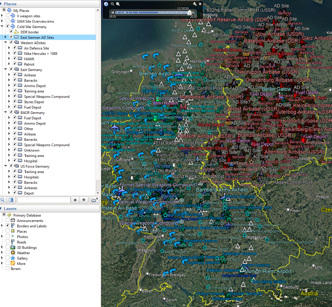
 [18th April update: Thanks to the thread contributors and all those documents, this is such a fascinating and amazing topic. This project was massively ambitious and in a competition for my time between everything else and a 5th month old Border Collie puppy with no manners, I submit my work to date to the community 'as is' to do what you like with! Attached kmz. ] I could use some help from the armchair army to check the Google KML I am producing, before public release. Using a combination of KML's from Speedy on the army rumour service for the British and Soviet installations, a filtered SAMsite overview and my own work to collect, locate and organize the US installations I have over 1210 Google mapmarkers in the most complete rendition of 1960-1995 Germany's Cold War installations. The KML will eventually become a key reference resource for locations in the upcoming DCS map. Mission makers can check the details provided for targets and mission use. The KML will eventually be imported to DCS as a rough template of locations. I don't intend to place any objects as there won't be a 1:1 parity and there are clearly too many, but it is enough to add sites for your missions. The KML for Cold War Germany comprises of: Over 1200 placemarks categorised and colour coded (so far) The inner border reference line East and West Air defence sites (for West, the Nike Hercules is available for pre 1984 but dates are pretty tough to get) British American Soviet/E. German --Airbases and minor Helicopter airfields --Barracks and installations --Ammo Depots --Training Areas --Special Weapons Compounds --Stores --Fuel dumps/CEPS The rough time range for these is 1960-1995. What I am looking for initially is anyone interested in helping expand on this, specially if they want to zero in on, for example, enriching the US Kazernes with any reference links, tidying up the current placemarks, finding names for the unamed ammo dumps, checking the data with online references, etc. I'm definitely interested in anyone with knowledge of the Eastern European theatre, the locations and names of units and their stations, the airbase complements and time ranges. Also those with good knowledge of the FEBA and plans who can identify major themes that can be added to the KML or fill holes and gaps, such as the areas east of Luneburg and Hamburg, east of Braunschweig, east of Salzgitter and Northeim, etc. Please don't ask for the WIP copy, it will arrive here when its done. Feel free to add details of the theatre to this thread. Whilst I've seen a lot of resources online, its not the finding of the information so much as the time it takes to create a nice placemark with links, find the modern day geo coordinates from the resource that is now hidden under a Lidl or BMW factory and so on. there's issues of time and date filters which I havent even attempted. It will never be perfect but thats not the aim. Cold War Germany.kmz
- 57 replies
-
- 33
-
-
-
 Please consider to implement the Fliegerhorst (Air Base) Wunstorf, located next to the town Wunstorf (near City of Hannover) and the big lake „Steinhuder Meer“ with its iconic Landmark Wilhelmstein is making history from its start of operation in 1934 to the present day. Location UTM: 32U 529025 5811992 ICAO-Code: ETNW In Operation: Luftwaffe, 1934–1945 Royal Air Force, 1945–1957 German Air Force, 1957–present (1978-present base of Lufttransportgeschwader LTG62) Landmark Steinhuder Meer: Biggest lake of Lower Saxony behind Air Base: Popular Landmark for Pilots: Wilhelmstein Fortress, built in 1761 on an artificial island in the middle of the lake:
-
Hello, I would like to be able to hear things while I'm in the F10 map. Not sure why the F10 map mutes everything, but it shouldn't. Ive missed many an RWR warning, BRA, or Jester call-out etc.
-
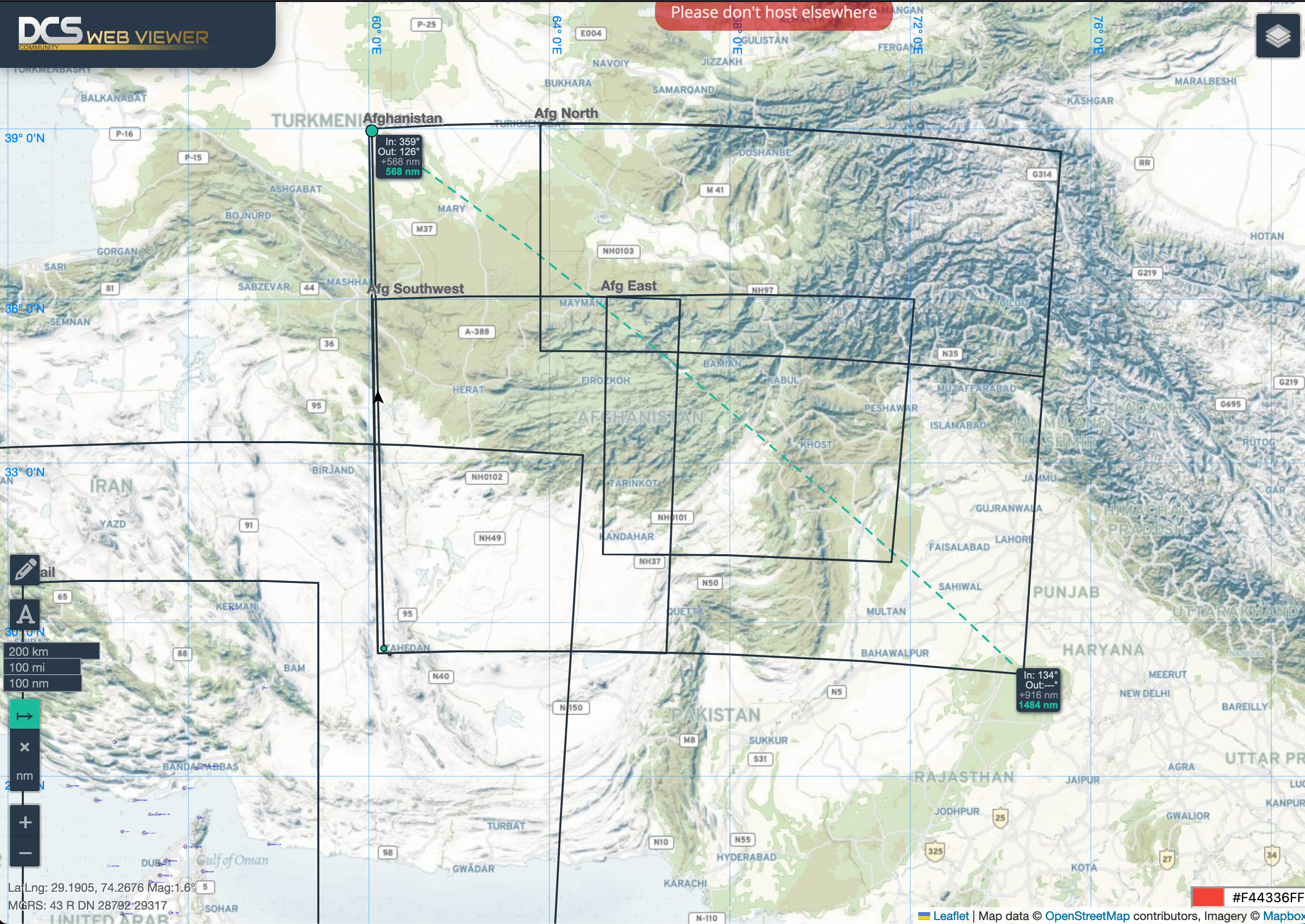
I've updated the coordinates in DCS Web Viewer. You can also draw and measure with the map tools. https://dcs-web-editor.github.io/dcs-web-viewer-deploy/?zoom=6&lat=34.488447837809304&lon=67.39013671875001
- 5 replies
-
- 13
-
-
-
- map
- afghanistan
- (and 1 more)
-
Kneeboards on pilot model is important for successful and immersive missions. Stopping you from leaving gameplay looking for radio frequencies or waypoints. I would like to see an improved resolution mostly from a VR standpoint, and maybe more available file types. I would also like to see the kneeboard to include mouse clickable controls and option to include a kneeboard on both pilot legs for those large missions. thanks
-
I have read now the TAC-000 through couple times and I can't find MAP DESG to mean anything else than radar ground mapping. It is pointed everywhere that when AG master mode is selected then the MAP is radar primary designation mode. As the AV-8B+ doesn't have the DMT, you are then left without the LST and TV Designation capabilities. And you need to carry TPOD to get those features. In the N/A Harrier the INS mode is secondary designation mode as it is HUD only mode (need to see target and TD inside HUD to move TD with TDC) and DMT is the primary one. But what is "MAP"? Where does it really come available for us? In the TAC-000 manual there are hundreds mentions how MAP is tied to radar variant, but only one (that I have found) to list it with N/A but it is where N/A and Radar variant is same and Day-time is without EHSD and FLIR. Right now the "MAP DESIGNATION" is mixing INS such way that pilot can move TD anytime when in INS mode, and the TD moves around in EHSD. This causes problems for players as well who are accidentally in INS mode and then they touch TDC and it does move TD around behind their aircraft because TDC is in "MAP DESG" (regardless that all in ARBS LST/TV mode states that those are disabled when reaching DMT gimbal limit and INS is automatically selected to avoid accidental designations, and they don't get automatically re-activated without pilot pressing SSS Aft again). The manual doesn't say anyhting of SSS Left activating any TDC actions on the EHSD digital moving map. It only say that continuous SSS Left will toggle between decentered and centered EHSD view. Can someone explain from where and why we should have "MAP"? As far what comes to manual, we should have only three main means to designate a target. 1) Laser Spot Tracker 2) TV contrast lock 3) INS visual targeting using HUD. Those are SSS main axis - Forward and Aft and are mutually exclusive from Left and Right. And others are: 1) overfly the target and pressing TOO to designate area below aircraft using RALT. 2) JTAC sends datalink transmission. 3) entering target coordinates manually. 4) Waypoint and waypoint off-set. 5) Any means to convert existing TD to Markpoint or Target Point (M# or T# in EHSD instead W#) and recall those as TD. 6) And then separate system, like the TPOD (but not really part of Harrier systems).
-
What DCS really lacks for VR Pilots is an update to the out-dated knee board. A real make-over! DCS needs a virtual EFB on our virtual lap. Like we do in the real world - we have an iPad on our lap. (EFB=Electronic Flight Bag). On that EFB we can run whatever apps we want. Here are some examples: Be it an aerial maps app (one that lets us slew the map around, zoom in and out, display or remove data layers such as different coordinate systems [MGRS,LAT/LONG], waypoints, terrain, Satellite imagery, terrain data, obstacles data, points of interest, Navids, routes, SAM and threat rings, weather data (dangerous thunderstorms, severe turbulence, winds aloft, etc..), and even mark something on the map freehand with an apple pen our finger, and much more. To that app you can add sensors like GPS, thus turning it into a moving map app, and even ADS-B data that turns it into a portable TCAS and updates the weather in real time. Be it a mission computer app or a portable data link app Be it a documents managing app that let us view PDF’s with our checklists, lists, aircraft manuals, mission data such as intel, objectives, coordinates, frequency lists, airport and approach charts, you name it. Be it Weight and Balance apps that would help us decide how to load the aircraft with payloads. I would suggest it to allow us to run real world apps on the virtual tablet (sort of like a virtual machine), for example ForeFlite, and be open to the public to write apps to this virtual tablet.. this could open up a market of apps for the virtual EFB, and lead to devs from the community write amazing apps for it. This EFB can also be linked to a real world iPad that would run a DCS EFB app on it that will allow us to freehand on the real life iPad with a real apple pen, and see it appear on the virtual tablet on our virtual lap in-game. Although the pilots in the 70’s didn’t have tablets and EFB’s in the cockpits, and it’s not realistic, they did have real hands and real maps and real pens and real knee boards that they could use to get all of this data that VR pilots just cannot access once the VR “helmets” goes on and limits our world to the DCS eco system. A virtual EFB could compensate all that and help us immerse into that virtual world. And of course one could limit the use of some of the EFB’s features through the mission editor, so WWII pilots won’t be able to cheat with a moving map or a portable data link app…. I also see an opportunity for Eagle Dynamics to make more income out of this - selling apps for the virtual EFB (a virtual App Store?), collaboration with real world vendors such as ForeFlite subscriptions, Navigraph subscription, and much more, even selling the real iPad app that would interface our real iPad/Tablet to the virtual EFB.. VR is the future of simming and It’s time for a makeover of that knee board. The sooner ED improves the immersion in VR - the better. The sky is the limit!
-
I just switched to a triple screen setup with 4K Monitors. Setting up everything with the options.lua and monitor.lua worked fine. Only one issue: when using the center monitor fur UI, the map in F10 and Mission Editor is shifted to the left. Right side is a blank part and every klick is offset (only on the map, not on sidebars, menues or anything else). I would guess the GUI is positioned 3840 pixels from the left side, the map only 3000 pixels. If i switch the UI to the right side the offset is doubled, if i move it to the left monitor (so coordinates 0/0) everything is fine. changing monitor resolutions and options.lua to 1080p also fixes it. Is it possible that there is some limit to offset the map? Any other 4K triple users having the same issue? Thx in advance for any help Attachment: options.lua and monitor.lua currently used + screenshot of the mission editor when running dcs with those configs. 3Cameras.lua options.lua
-
Hi everyone, I have a proposal for improvements to the map system used in the Hind. The current system works fairly well but it does have a number of shortcomings: Some areas have no maps and are completely blank. It always initialises with your position at the centre. The maps are fairly low resolution (not talking about scale). The only additional marks are waypoints and connecting lines. The map system automatically switches maps when flying across boundaries, and automatically places the own-position mark over the correct spot when changing maps or scales. Custom Images Firstly, as I (and probably a few others) have mentioned in several threads, it would really be great if we could load custom map images into the map slot. A way of going about this is to have a separate tab in the mission editor, where we can browse for and add a library of images to, exactly as with the briefing images. It would also be a good idea to have this image library be available via a menu option in the ground crew (perhaps tied into the mission planner system planned for DTC implementation). Then in the pilot cockpit, the cover/door for the map slot should be a clickable object. When open, the map area underneath would also be able to be clicked too. When left clicked it would bring up the library of images and their filenames, allowing you to select an image. When selected, the image loads into the map slot and the cover closes. It's then up to the pilot to set it up properly (by updating own position and selecting the appropriate scale, if applicable). It doesn't even need to be confined to maps of the 2 valid scales - the system has no way of knowing what has actually been placed into the map slot, whether it's a map of valid scale or a picture, a checklist or anything else that'll fit inside the slot. If you want to use the doppler system, then it's solely dependent on the pilot to place in a map of a valid scale, then to set their own position accurately and select the correct scale (and all that does is control the speed of the own-position mark for a given speed of the aircraft). Obviously if whatever is loaded isn't a map of a valid scale, then the own-position mark won't be usable (or even be applicable); in this case, however, it can be turned off independently from the rest of the doppler system. Doppler navigation however can still be achieved by using the DISS-15 readouts and course needle, in exactly the same fashion as the Hip. Ideally the map slot would accept any image resolution and would scale it appropriately to fill the map slot. If no images are in the library or the ME/pilot hasn't set any, then the system should fallback to the current system whereby a map is automatically selected based on current position and automatically changes based on scale and when the player reaches the edge of the current map. Though personally, the automatic updating of the own-position mark should be something in the difficulty options; the real system requires it be manually updated whenever the map is changed (either for a different location, or using a map of a different scale). Currently however, the own-position mark is automatically placed at own position and automatically updates when changing scale or when changing map. For those that want it though, the current implementation could stay as an option in the Mi-24P's misc settings. This is broadly similar to what was requested in this thread, but I'd extend it to custom images in general. User Marks/Drawings Another request is one shared with the F10 map and kneeboard, and that is the ability to edit images by drawing on them or placing marks on them. How this could work is similar to how you load map images into the slot above, so you would click on the cover to open it and then click somewhere in the map area. Only this time if the user right-clicks, it brings up the image in 2D (like the kneeboard and NS430 pop-up), with a few drawing tools available (such as markers in different colours and sizes, a set of symbols, an eraser/undo etc), allowing the user to draw on the image as desired, for whatever reason (such as drawing out a route, marking/annotating points of interest, marking possible enemy positions/axis of advance, whatever). When done the new image gets loaded into the slot, and the cover closes (perhaps there could also be an option to save the edited image, allowing you to use it later). EDIT: user marks/drawings was previously requested here.
- 18 replies
-
- 11
-
-
-
 There are many maps in DCS, available and in developement, but except for WW2, they are all modeled like in civilian simulator as 2020 modern day timeframe - and this takes away some of the combat simulator atmosphere and makes DCS feel like cockpit simulator/civilian simulator/sandbox etc. when you fly historical aircrafts like 1944 Bf109, 1972 MiG-21bis or 2005 F/A-18 over 'modern day 2020 civilian map'. Other military simulators had maps modeled as particular warzones with proper timeframe. All the maps like 2020 Persian Gulf, Marianas, South Atlentic, Sinai, Kola Peninsula, Australia etc. are proper only for fictional scenarios - there were no wars over them in ~2020. What is more even "modern" modules like F/A-18, F-16, Apache etc. are modeled as year ~2005. 15-20 years old standard of second Iraq war, not 2020. Fictional scenarios are not exactly bad, but there is a problem when all scenarios have to be only fictional. My wish is to have e.g. 1950 Korea map, or 1967 Six-Day-War Syria map, 1960s Vietnam map, 1973 Yom Kippur Sinai map, 1980s Libyan map, 1980s Iraq/Iran border map, 1991 Gulf War map. As they would portray real all out conflicts and match aircrafts we have in DCS. Or when fictional - at least some plausible like 1962 Cuban Missile Crisis map of Cuba, Cold War Fulda Gap divided Germany map e.g. during Berlin Crysis, Arctic Crisis 1970s-1980s Kola Peninsula map etc. cheers
- 20 replies
-
- 12
-
-
Hi @OnReTech, is it possible to know something more about estimated date of release EA version if it's not top secret ? I'm not talking about a certain date, but what period are you aiming to make with the completion of the version for release more or less (own proposition). Month or quarter maybe. Maps looks promissing, Im waiting for it too and some the last Wags videos was recorded over Sinai map so looks like more soon than far . Last time it was something like this with SA map and Apache, 1-2 months later the map was released :).
- 59 replies
-
- 2
-
-
- early access
- sinai
- (and 1 more)
-
base on a discord post by dotrugirl, I wonder What are the differences between the current and future develop terrain vs Earth map? 1. what is the business model of Earth Map ? 2. is it going to render on Cloud or any cloud technologies ? 3. What are the key differences in regards to Visual effects? 4. Is it going to use similar damage model and effects? (Flat earth people finally got a point! )
-
 Trying to work out if the ground/area is suitable for a unit/building/base in a top down flat 2d representation of a map in 2022/2023 is beyond lunacy. I get we're dealing with a legacy mission editor, but this needs a significant overhaul and bringing up to date.
 -
Fascinating map of forces and points of interest, Syria and surrounding areas https://www.google.com/maps/d/u/0/viewer?mid=1M-_ymjR9xwOK7KMikOcUFSAE1ac&ll=36.03414564373511%2C37.36432349847946&z=9
-
 The building is there (Beirut), but there is no collision detection, falling through the building.
 -
Nothing I can't hold my breath for, but it irks me ever so slightly that every single unit on the DCS F10 map view has its proper designation... except SAM sites. Every single Soviet/Russian SAM has its respective NATO designation. I think it would make sense to toggle between NATO and proper designations depending on whether the Editor Icon Style setting is set to "NATO" or "Russia". Being more familiar with names like '9K330 Tor' or '2K22 Tunguska' or 'S-300' means it requires an extra mental step to translate what I'm seeing on the Map. Not that it would take particularly long to memorise, but it's just preference.
-
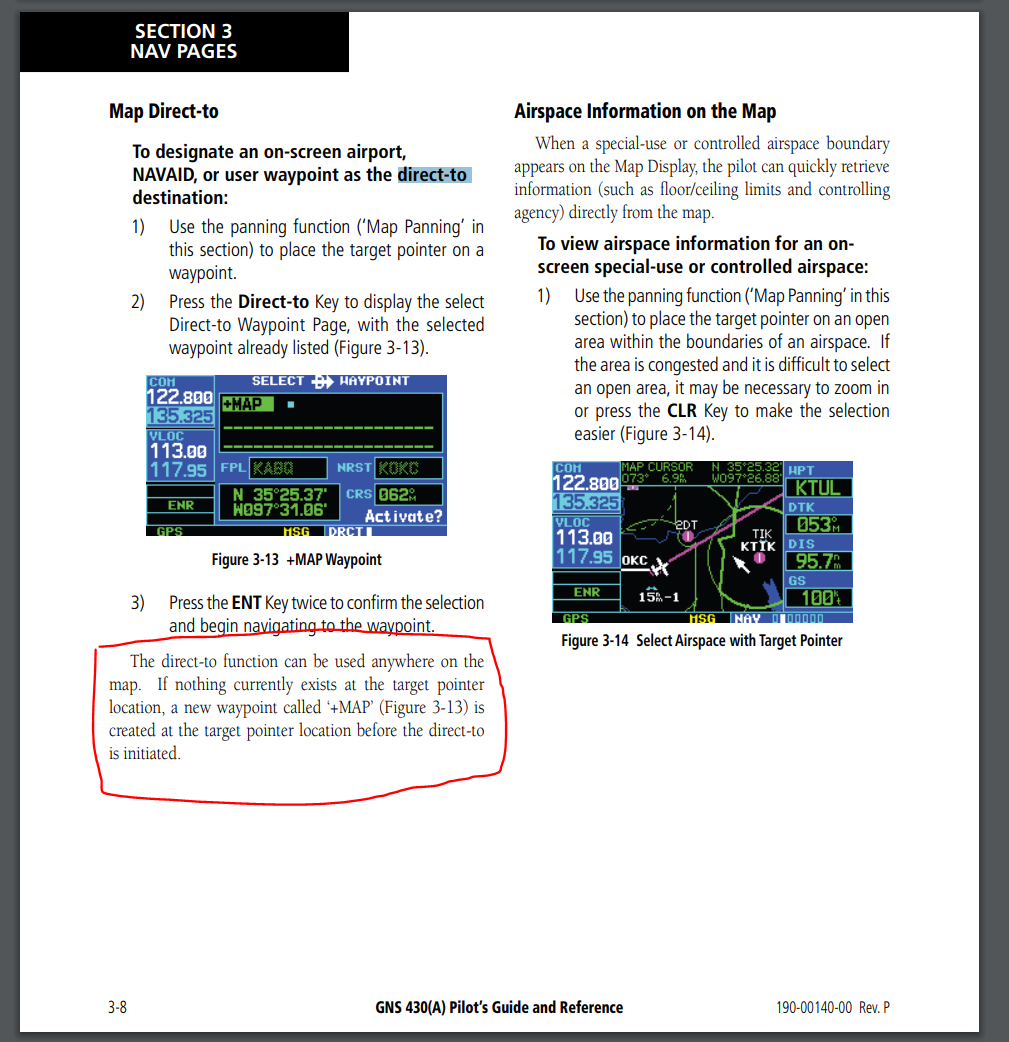
Hello! Having used the real counterpart to the NS430 quite a lot, I am requesting a feature to be added to the cursor when in map mode. Currently: When you activate the cursor when in the map screen and move the cursor to any arbitrary location and press the Direct-to -button, the NS430 presents you with either your current location (the airfield you are at if you are on the ground) or alternatively the point that the cursor is over (though this bugs out at times). Request: As per the real device, if you set the cursor at a point on the map where there are no waypoints (user generated or otherwise) the device should present you with a new user waypoint marked "+MAP" with the current cursor coordinates. This allows the user to set their destination quickly to any point on the map without needing to first navigate to the user waypoint menu and then build a new waypoint by setting coordinates. The following picture is taken from the official GNS430 manual (https://static.garmin.com/pumac/GNS430_PilotsGuide.pdf) Regards, MikeMikeJuliet
-
 Hi everyone, Since the initial release of 2.5.6 over 2 years ago, the Straits of Hormuz/Persian Gulf map has sported drastically improved lights and lightning system compared other maps. The majority of maps typically use low-resolution 2D sprites that don't naturally bloom, often don't account for line of sight, are sometimes fixed (so when viewed from the side they clearly appear 2D), while having poor visibility at distance. The SoH/PG map by comparison looks much more natural, with lights that appear to bloom much more naturally, typically account for line of sight, with drastically improved visibility at a distance. It's also worth pointing out that many of the sprites seen (in particular those used for aircraft warning lights) seem to be used as the default exterior lights for many aircraft and modules, including recent ones (though in the case of the Apache and Hind, they're much smaller), it's also used for flares. While the lights of the SoH/PG map aren't perfect (though the issues they have a more minor: size, positioning, lack of illumination, some bulbs aren't illuminated), they are far superior compared to other maps, there really is no contest. I'll post an absolute load of screenshots comparing 2 maps (see here for the Imgur album) - the SoH/PG map and the latest map, the Marianas. The lights used in the Marianas are common to all other maps (but have increased size in Syria and reduced size in the Caucasus). For both the SoH/PG map and the Marianas, the date and time was set to the 21st of June 2016 (full moon), at midnight. Default weather conditions were used, just with the no clouds preset set. Aircraft Warning Lights: Approach Lighting System: Built-up Area: Flood Lights: Hangar Lights: Lights at Distance: PAPI Lights: Runway Edge Lights: Runway Threshold/End Lights: Runway on approach: Street Lights: Taxiway Lights:
 -
Criteria according to which maps for DCS should be selected
bies posted a topic in DLC Map Wish List
I have some suggestion when it comes to map chose, but i would like to know community opinion. It's visible there are two main criteria ED has chosen, first, dominant, is current nowadays political tensions. - after Chechnya war the Crimea map - after USA/Saudi - Iran tensions the Hormuz Straight map - after USA - China tensions the Marianna map Second is real life full scale military conflicts with timeframe corresponding with timeframe of DCS modules and assets, this is underrepresented but last Syrian map fits this category. (But even in this one single case I'm really not sure if the present day Syrian totally asymmetrical war, without any air combat, just low scale bombing some helpless terrorists/insurgencies wasn't the main criterion, unfortunately.) Why I think so? 1) DCS is about history and it has to be for obvious reasons, even the most modern modules like A-10C, F/A-18C, F-16C are around 2005 variants, yes, it's 15 years ago. Not today. Hornet i.e. is phased out from US Navy years ago. 2) After all, there was no full scale military operation and tensions de-escalated to some degree in Hormuz or Guam and this can make maps not aging well. So maybe the best criteria would be to base the map chose on real file full scale military conflict in a timeframe corresponding with timeframe of DCS modules? 1) I.e. instead of Straight of Hormuz - the map of Kuwait/Southern Iraq/Iran boarder. With full scale Iraq-Iran war lasting 8 years, with our F-14A, F-5E, Gazelle, MiG-21bis,Huey, near future Mirage F.1, MiG-23, MiG-29A, Mi-24, nearly all ground assets like MIM-23 Hawk, S-125, Kub, ZSU-23-4 etc. We could recreate the whole conflict in a reasonably full way. Or full scale Desert Storm 1991, the last full scale war, with thousands of tanks, APCs, artillery pieces, and more than hundred aircraft shoot down in last dogfights in history with our F-14A, MiG-21bis, Gazelle, FC3 F-15C and A-10A, near future A-7E, Mirage F.1, MiG-29A, MiG-23, Mi-24, Mi-8, F-15E, and most of the ground assets / AI planes of the war. 2) Or full scale years long Vietnam war where aircrafts were being shoot down by thousands in ground attacks and air dogfights. 3) Or Korean Peninsula with another real life full scale symmetrical conflict with hundreds of aircrafts, hypothetical later Cold War flashpoint and today's tensions. BTW: Privately Syrian map is my favorite not only because it's great from technical point of view but first and foremost because it was a place of real life full scale wars to recreate with hundreds of aircrafts dogfighting over Israeli Syrian border in three major wars from late 1940s to 1980s, thousands of tanks, APCs, air defense - instead of hypothetical what if scenario only. I also love the idea of RAZBAM's 1982 historically accurate Falkland War map, with ground, naval and air assets of this conflict. ------------------------------------------------------- What is your opinion in this matter? Do you prefer maps of hypothetical conflicts and today's tensions or historical full scale wars corresponding in timeframe with timeframe of DCS modules and ground assets/AI airplane of the era present in DCS? -
Hi Everyone, Does anybody know whether or not the Marianas map will transition away from the flat maps, and instead be shaped as a surface element of a sphere? Like this (on the right): This map can be made quite expansive (and it looks like its planned to be about as expansive as the current Caucasus map), whereby having a flat map becomes less of an accurate approximation; it also means that RADARs won't have to employ a workaround to imitate LOS limitations on a spherical Earth - which also has the added benefits of having visual and RADAR LOS coincide with each other (as they should). Also, if the end goal is to have the world in DCS World (even if it is a long way out) wouldn't it make more sense to have it fit into a sphere? How I imagine the world would work in DCS is you'd probably have generic terrain and airfields, and then have our current theatres replace certain areas - in exact same fashion to many flight simulators.
-
Currently the view in the editor is bound by the defined map edge. This it turns out creates a lot of weird behaviour and annoyance when using a wider aspect ratio display, commonly jerking the view around when working at certain zoom levels or near the edge of the map, especially when opening/closing other panels. I would like to request a removal or significant increase of the map pan/zoom limits, would simply suggest that off-map space that would end up being in view as a result at times simply be blank (black, green, white, whatever) space.
-
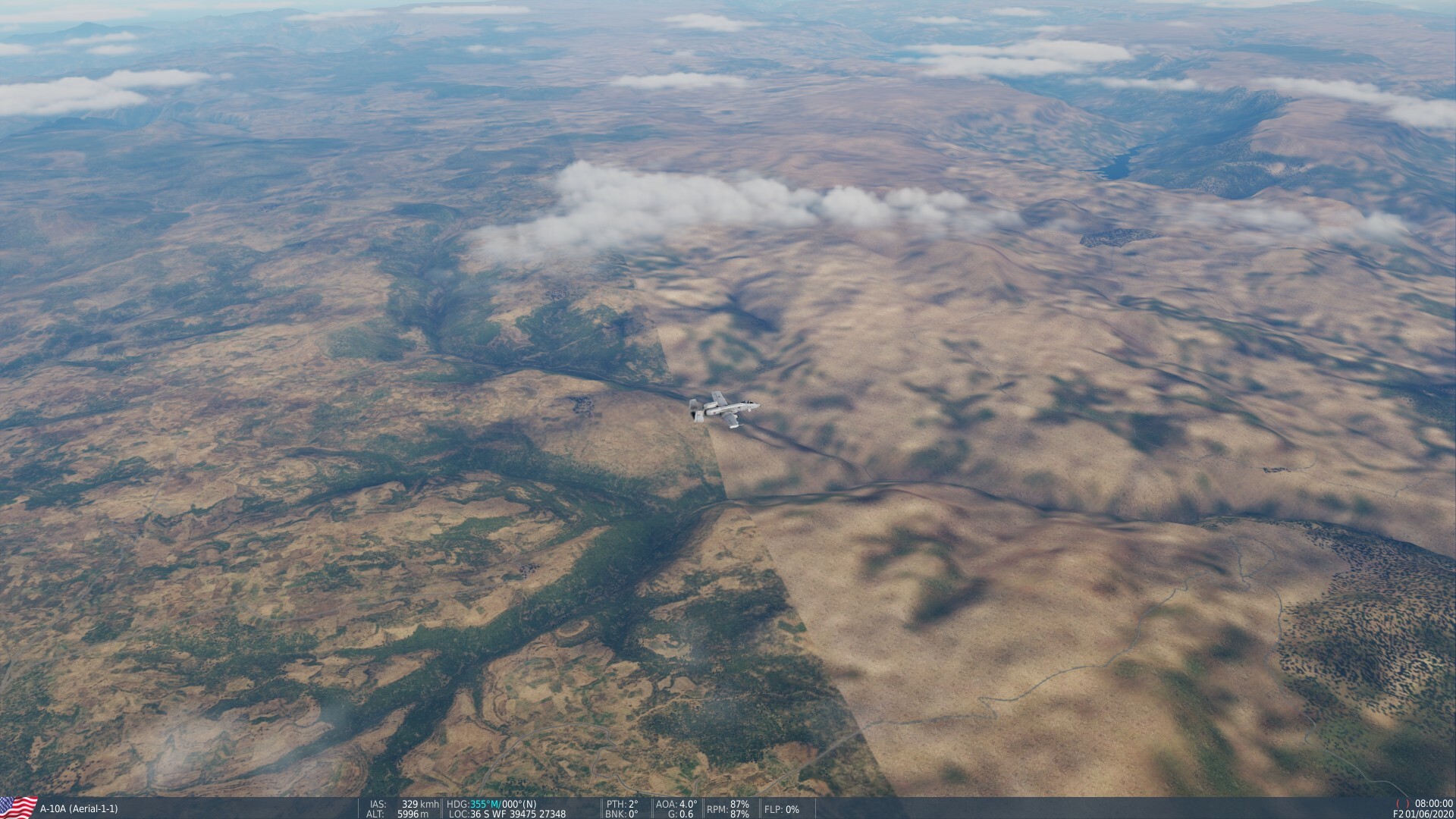
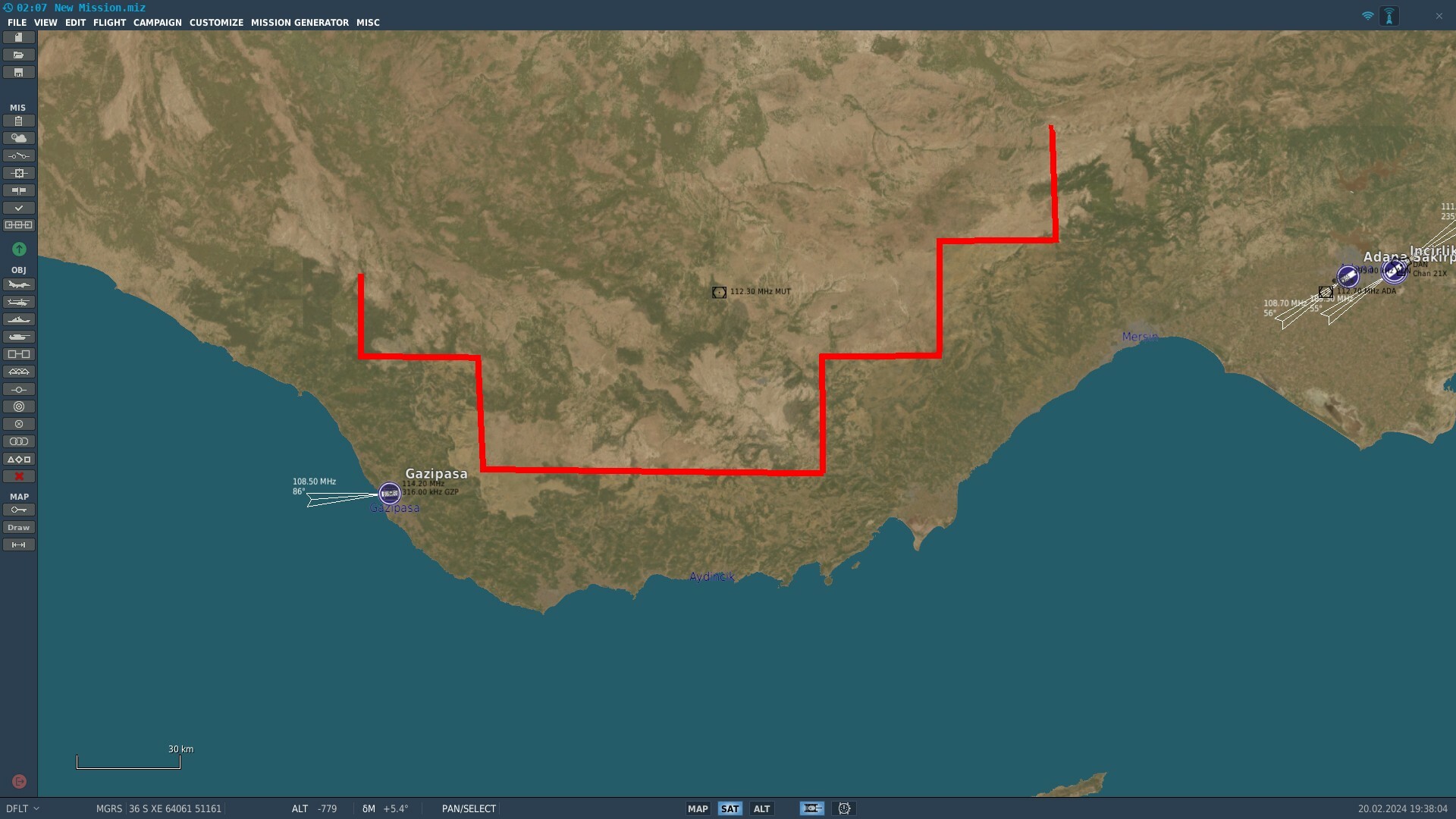
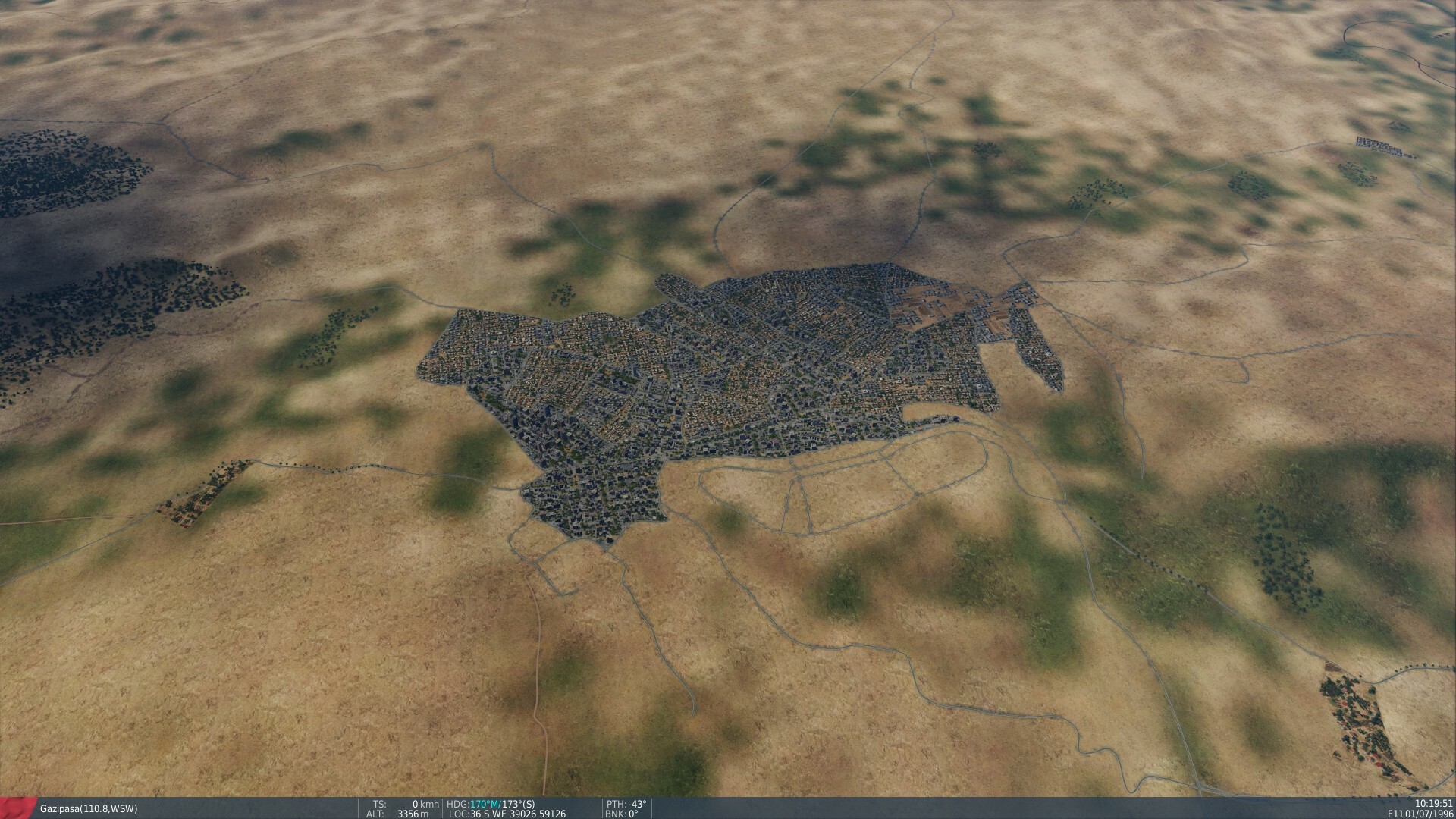
In the area around Gazipasa and the area between Gazipasa and Incirlik, the ground textures suddenly change and become extremely low resolution. This is a populated part of the map with roads, villages, named towns and electrical grid so the low resolution textures are probably not intentional. See attached pictures. Example of the very jarring texture change, detailed villages and roads can be seen in the "low-res" texture area. The cut-off line where low-res textures begin is marked with red


.thumb.png.d43db0aa51621a39a2161ec5c6fff372.png)