Leaderboard
Popular Content
Showing content with the highest reputation on 04/19/23 in all areas
-
From YT channel: null
 10 points
 -
Your welcome Raptor. I have completed the upgrade of the Tarantul Class Corvette but I need to tweak the weapons a bit more. You all will enjoy the new upgrade. Thanks, Enoy! Absolutely, your mind has to be clear when it comes to coding. Otherwise, you will make a lot of mistakes. For example, The Arleigh Burke Class destroyer I'm working on has 88 or so Missile Cell launcher hatches. Each has to be animated and coded along with the other weapons so it takes time. Getting the motivation to do it is another thing. It's one thing we dread but we have to do it to make the mods look more realistic. lronghost, yes I have a great mod of the Zumwalt. Not sure when I will get to it because I have so many mods to create. Yes, theirs an older version out there but it doesn't work anymore. Vegabond, I noticed that also. That is a glitch. So initially the launchers were too close together and so they would somehow collide with each so I spaced the launchers out but every now and then they will explode. DCS game engine controls when the missiles are launched not us. We just code and animate and the DCS Game engine does the rest. It happens sometimes but other times it doesn't. An alternative is to rotate the missile launchers outward to avoid them colliding. There's always a way to get around it. There's this thing called Life. So outside of modeling I have a family plus I live with chronic back pain. So I have to manage all of that and sometimes life gets in the way which stops me from modeling some days. So I try to model when I'm able. That's the reason I don't create a lot of mods at once. Chronic Back Pain will sometimes dictate my days. Sitting here modeling can take days and weeks as Enoy mentioned. So please have patience as I'm a one-man shipward. Thank you all for your interest in the mods. Plenty more to come. Your interest keeps me motivated to create more DCS AI Ship mods. Stay Tuned! Forgot to mention USS Blue Ridge is finished. I will release her later this week. Hopefully the Tarantul Class as well.9 points
-
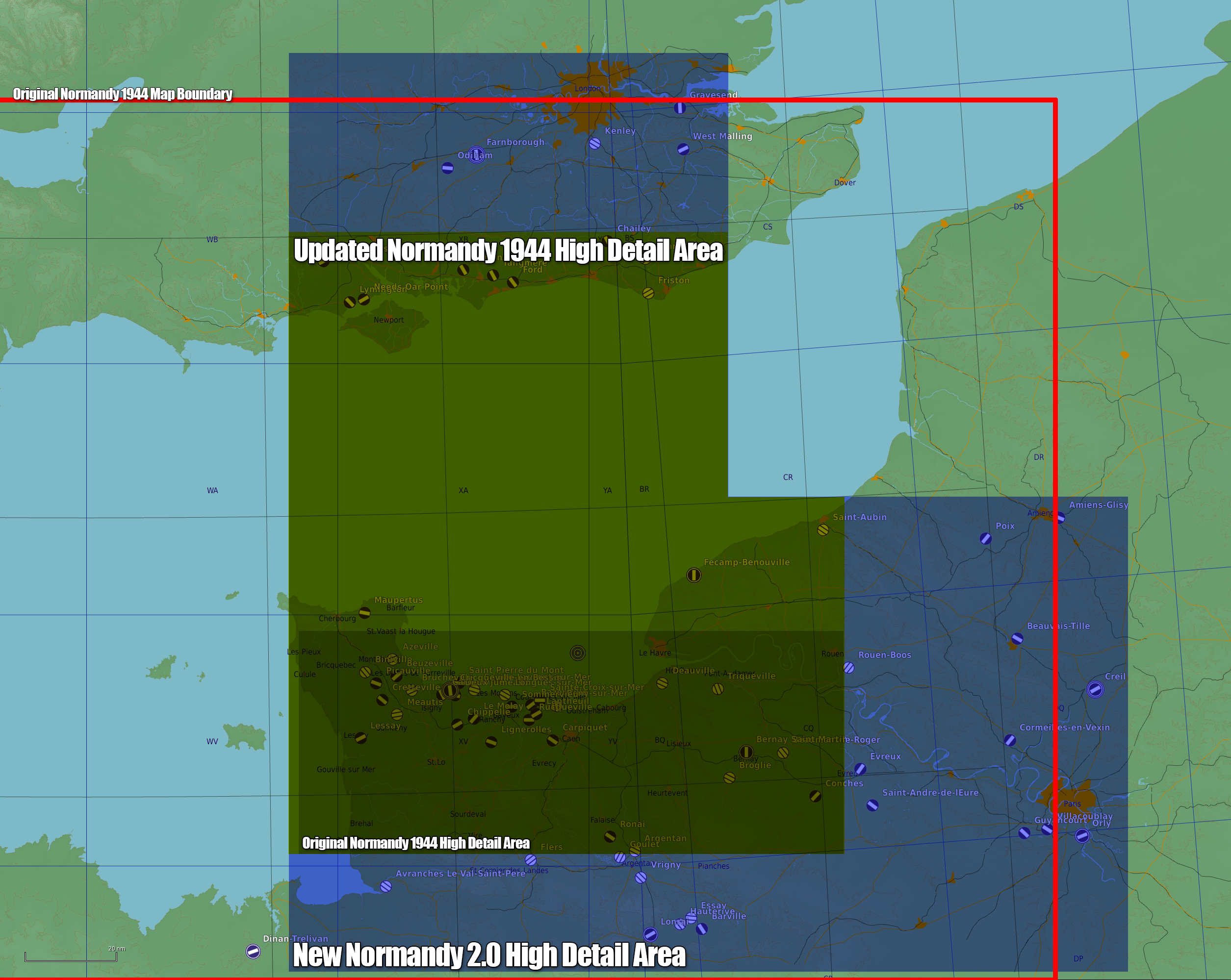
DCS: Normandy 2.0 Update FAQ When will it be released? Very soon you will be able to enjoy all the hard work done by Ugra Media. What is DCS: Normandy 2.0, and what updates does it bring? The new DCS: Normandy 2.0 map is a significant upgrade over the original DCS: Normandy 1944 map and will be a greatly enhanced experience of war-time Normandy. DCS: Normandy 2.0 is significantly larger than DCS: Normandy 1944 and contains: much greater detail; historical accuracy; texture resolution; much larger high-detail areas (including London and Paris); updated map objects such as models of buildings, trees, bridges, airfield objects, rail lines, roads, fences, poles, and more; many new and remodelled medium to small size urban locations such as new ports, airfields, factories, rivers, canals, and much more. The image below is a map size and detail comparison: The release of this new map benefits all existing owners of DCS: Normandy 1944. Owners of the original DCS: Normandy 1944 map will receive a free update that enhances the whole area of the original map to the same high detail level as in DCS: Normandy 2.0. The free update will also include the new much larger DCS: Normandy 2.0 total map area and airfields but at a lower level of detail. For a limited time, players that own DCS: Normandy 1944 or DCS: The Channel are eligible to upgrade to or purchase DCS: Normandy 2.0 for a discounted rate. Please read further into the FAQ for more detail. Please note that DCS: Normandy 2.0 supersedes DCS: Normandy 1944, which will no longer be available for purchase after the release of DCS: Normandy 2.0. Information describing for each user case continues below. The FAQ provided here should answer the most common questions you may have. How much will it cost? DCS: Normandy 2.0 will be $59.99 USD, but has a 20% discount applied while in early access and is $47.99 for this duration. For a limited time, players that own DCS: Normandy 1944 or DCS: The Channel are eligible to purchase or upgrade to DCS: Normandy 2.0 for a discounted rate. Please see the pricing matrix below: You already own: You get DCS: Normandy 2.0 for: Normandy 1944 $14.99 USD The Channel $14.99 USD Normandy 1944 & The Channel $9.99 USD The pricing above may be subject to change. How do I purchase DCS: Normandy 2.0? And am I able to try it first? Click here if flying in Open Beta (will be updated with store page on release) Click here if flying in Steam (will be updated with store page on release) If you are flying in Open Beta you may activate a two-week Free Trial of DCS: Normandy 2.0 by pressing the ‘Trial’ button beside the module in the E-shop. You will then be able to download DCS: Normandy 2.0 via the in-game module manager and will have full access to the new terrain for two weeks. The Free Trial programme extends to most DCS module; look for the ‘Trial’ button in the e-shop to participate. I already own DCS: Normandy 1944. What happens? Excellent! Your existing DCS: Normandy 1944 map will be updated for free so that the whole area of the original map is in the same high-detail as in the DCS: Normandy 2.0, and you will benefit from updated airfields and a significantly increased total map area but at a lower level of detail. You will still be able to play on your favourite servers or with friends even if they upgrade to DCS: Normandy 2.0 and you don’t, but your areas of high-detail are significantly smaller and may be missing world objects. If you wish to, you may pay $14.99 USD to upgrade to DCS: Normandy 2.0 for all the benefits described above. I already own DCS: The Channel. What happens? DCS: The Channel remains a separate map made by Eagle Dynamics SA and has not been updated regarding this release. In the corner where there is some map overlap, details between the maps may not match up. See the included map showing the DCS: The Channel map vs the DCS: Normandy 2.0 Map Specifically, DCS: Normandy 2.0 has different airfields, high-detail areas and focus versus DCS: The Channel. If you wish to, you may pay $14.99 USD to purchase Normandy for all the benefits described above. I already own both DCS: Normandy 1944 and DCS: The Channel. What about me? You will automatically benefit with an updated DCS: Normandy 1944 map as described above, but as you additionally own DCS: The Channel, you may upgrade to DCS: Normandy 2.0 for just $9.99 USD I don’t already own DCS: Normandy 1944 or DCS: The Channel. What are my options? The DCS: Normandy map is available for purchase for $59.99 USD with a 20% discount while in Early Access. The original DCS: Normandy 1944 map is no longer available for purchase. I have DCS Normandy: 1944 and don’t want to pay for an upgrade! You don’t need to; your existing DCS: Normandy 1944 map will automatically update and you’ll receive updated airfields and a significantly increased total map area. You will still receive a discounted price if you ever do decide to upgrade to DCS: Normandy 2.0 for all of the benefits described above. Can I fly with friends or servers if we have mismatching versions of Normandy? Yes, you will still be able to play with friends and on your favorite servers even if you have DCS: Normandy 1944 and they are running DCS: Normandy 2.0, or vice-versa. You will be able to fly together but the detail that each of you sees will differ. Those flying DCS: Normandy 2.0 will have a significantly larger area of high detail, including London and Paris and many new and remodelled medium to small size urban locations such as new ports, airfields, factories, rivers, canals, and much more. Will I have both maps after updating or purchasing? No. The normal upgrading procedures will be followed and all players will only have one map installed, but their versions may differ. Those that upgrade or purchase new will see and fly DCS: Normandy 2.0, and those that don’t upgrade will see and fly DCS: Normandy 1944 (but with updated/upgraded airfields) and a larger map size overall (but in lower detail and with missing world objects). The original DCS: Normandy 1944 map is no longer available for purchase How big is DCS: Normandy 2.0 compared to the DCS: Normandy 1944 map? Please see the attached image that illustrates the low and high-detail areas of DCS: Normandy 2.0 compared to the original DCS: Normandy 1944. DCS: Normandy 2.0 is significantly larger overall with much greater areas of high detail, including London and Paris. DCS: Normandy 2.0 spans 400x600 km, with the majority of that in high detail. What new cities and landmarks have been added? Chief among them are London and Paris, but many new medium to small size urban locations make up the greatly expanded area and include new ports, airfields, factories, rivers, canals, and more. Most of the DCS: Normandy 1944 map objects have also been greatly improved; for example: buildings, bridges, airfield objects, rail lines, roads, trees, fences, poles, and much more. Am I paying for the same map twice? No. This new map is a significant upgrade over the original and will be a greatly enhanced experience of war-time Normandy. Please read What is DCS: Normandy 2.0 above for more detail of the changes. Please also read I already own DCS: Normandy 1944. What happens? above for more detail of the differences. Why create DCS: Normandy 2.0? The original DCS: Normandy 1944 map was created using older map technology and tools which rendered it impossible to simply expand and update the existing map to achieve DCS: Normandy 2.0. DCS: Normandy 2.0 has been created with new map technology and tools that have allowed us to increase the map size and amount of detail greatly. In order to make the maps compatible with one another, the airfields in the original map have all been updated so that the spawn locations match. This way, players can fly together regardless of whether they have the new DCS: Normandy 2.0 or DCS: Normandy 1944. What about my missions and campaigns? Some work will be required to adjust for some of the changes to the map. All existing airfields have been updated and so spawn-locations, script triggers, and so on will need to be checked and re-worked. New airfields have been created entirely, so there is much greater opportunity for mission and campaign scenarios. For example, many of the UK airfields have been updated heavily to be more historically accurate. Campaigns such as those from Reflected Simulations have been updated and should be working at release. Please watch his video on this here. ED and Ugra Media will work hard to get the remaining content updated shortly after the Early Access release. If continuing to fly DCS: Normandy 1944, missions that have been updated to suit DCS: Normandy 2.0 might reference world objects you will not be able to see without the update. Will the framerates be worse than the current DCS: Normandy 1944 map? Using the latest Terrain Development Kit (TDK), DCS: Normandy 2.0 has been well optimised and so despite a great increase in the number and detail of objects you should see no loss in performance compared to the original DCS: Normandy 1944 map. This will also be aided by the recent release of Multi-Threading by Eagle Dynamics. Please see here for details. Will there be winter textures? At this time, no. We plan for DCS: Normandy 2.0 to include Summer as it is being created around operations in Normandy in the summer of 1944 (Opération Neptune) but it will also include Spring and Autumn seasons. What airfields will be included at release? The total number of airfields has been increased to 50 for the Early Access version. Both owners of DCS: Normandy 1944 and those that upgrade to or purchase DCS: Normandy 2.0 will see all of these. Please see the following list of the initial airfields, which may increase after the Early Access release: Airfields in France A1 Saint Pierre du Mont A21 Sainte-Laurent-sur-Mer Fecamp_Benouville Flers A2 Cricqueville-en-Bessin A24 Biniville Evreux Goulet B17 Carpiquet A6 Beuzeville Guyancourt Hauterive A12 Lignerolles A8 Picauville Villacoublay Lonrai A14 Cretteville A9 Le Molay Saint-Andre de l Eure Poix A15 Maupertus B11 Longues-sur-Mer Orly Ronai A16 Brucheville B2 Bazenville Amiens_Glisy Rouen-Boos A20 Lessay - оригинальны B3 Sainte-Croix-sur-Mer Argentan Saint-Aubin A3 Cardonville B4 Beny-sur-Mer Avranches Le Val-Saint-Pere Triqueville A4 Deux Jumeaux B7 Rucqueville Barville Vrigny A5 Chippelle B8 Sommervieu Conches Broglie A7 Azeville Beauvais-Tille Creil Beaumont-le-Roger B9 Lantheuil Cormeilles-en-Vexin Deauville Bernay Saint Martin A17 Meautis Dinan-Trelivan Essay Airfields in UK Chailey Stoney Cross Farnborough Ford Funtington Gravesend Heathrow (as it was at this time, it is under construction and not usable) Kenley Needs Oar Point Tangmere West Malling Deanland Friston Lymington Odiham We hope that you thoroughly enjoy exploring and experiencing the incredible new WW2 theatre that is DCS: Normandy 2.0. We would also like to extend special thanks to our partners Ugra Media for their continued dedication and hard work. As always, we also would like to thank you for your continued passion and support. Yours sincerely, Eagle Dynamics and Ugra Media
8 points
-
Because if there's a way to modify the dots to what the OP has done, then there is a way to modify them even bigger and bolder which can be exploited. ED is right to lock it down in the IC, and hopefully they are implementing a new version of the contact dot similar to the OP's mod.7 points
-
Thanks, Gogi12! I appreciate it. As a gift from me, I have released the USS Blue Ridge LCC-19 Ver 1.0.0 with the livery of the USS Mount Whitney LCC-20 early. Page #1 of the Forum # 28. There will be version 1.0.1. I'm updating the textures via Substance Painter. As always. If you experience any technical issues please PM me and I will gladly correct it. USS Blue Ridge (LCC-19) is the lead ship of the two Blue Ridge-class amphibious command ships of the United States Navy, and is the flagship of the Seventh Fleet. Her primary role is to provide command, control, communications, computers, and intelligence (C4I) support to the commander and staff of the United States Seventh Fleet. She is currently forward-deployed to U.S. Navy Fleet Activities, Yokosuka in Japan.6 points
-
Few new screenies from M2M:6 points
-
Thanks, Guys! I think a combination of 24 years of Naval Service and over 12 1/2 years of operating US Navy Tugboats, Harbor Ferries, and Piloting Naval ships, Submarines, US Coast Guard, and Commercial vessels has taken its toll but I manage the best I can. Thanks for your kind thoughts! I really appreciate it.6 points
-
To those who don't have the JF-17 (suboptimal decision, but I'm not judging you ) Chuck's guide - that's how the thing looks in the Jeff: null
6 points
-
Centurion C-RAM 1.0.0 released! Changelog Version 1.0.0 Release version
6 points
-
уважаемый тов. Logan54! если Вам кажется, что у нас в DCS: Ми-24П всё "слеплено".. "понерфлено"..." имбово".. "халтурненько", то имхо это проблема особенность Вашего восприятия. А если выражаться в конструктивном русле - то приложите плиз Ваши аргументы-материалы не из кино, а из реального ПН. Картинка ,которую Вы приложили в качестве сравнения с моделью сетки из DCS, не соответствуют описаниям из спец.литературы, где четко указаны угловые размеры: - поля зрения окуляра (при х3.3 и при х10); - размера элементов прицельной сетки относительно поля зрения , и главное - относительно другу друга (например центральной марки относительно штрихов сетки). Кроме того, Ваш "референс" не соответствует изображениям на фото, которые были сделаны сотрудником музея ВВС, который сумел снять сетку на фотоаппарат. Т.е. всё, о чем упоминал тов.IDDQD - верно.5 points
-
5 points
-
Eh, as a Phantom fan, that is way overblown in my opinion. Being two seater does nothing to alleviate tricky flying characteristics, it takes away load of working some of the (ancient and frankly janky) avionics and gives an extra pair of eyes to look outside, but the thing is still as tricky to fly and pilot still has to do that. But to be fair, pretty much nothing from the period is easy to fly anyway. In a dogfight vs contemporaries, it is roughly equal-ish really, but even MiG-21 is going to be easier to get the best out of I think, same goes for the F-5. Mirage F1 proved to be surprisingly tricky but that may well be flight model being in an early state. Israel, having F-4Es and Mirage IIIs, most often used old Mirages in the air to air role from what I know for example. As for the avionics, they are super cool especially for the period, and are also utter jank Solid BVR weapons sounds like a solid overstatement to me. AIM-7F seems to be the top possibility, and Mirage's Super 530F is somehat better than that, and so will the upcoming MiG-23MLA's R-24R will be, only the margin will be greater in favor of R-24 I think. F-4E's radar will be mediocre for air to air, especially in BVR it will have a lot of limitations like no look down capability. Also unlike Mirage F1 or MiG-23MLA, or even F-5E-3 to some degree, it won't have a good close in quick acquisition mode afaik. MiG-23MLA will also have an overall better air to air radar that is easier to use, has a better range, and can do at least some look-down. Naval F-4s do fix these issues in air to air, but give up the gun, and only catch up to F-4Es especially lower speed maneuverability pretty late, and they also completely give up all the advanced air to ground capabilities from F-4E. Speaking of those capabilities, earlier mavericks are (unlike in DCS) so-so, F-4's bombing computer was so much loved in Vietnam, pilots just used bombing tables or flat out "used the force" instead, and the targeting pods (while for me will be awesome for that reason alone) were super janky. Pave Spike, the pod we'll get for the first variant, is a day-time TV only system with low resolution, and thus low magnification/range, no automatic target tracking capability to speak of, and only quick cueing options are "look left/right/ahead". Between 1974-1984ish, F-4E was one of the very few, perhaps even only aircraft that could do both decent-ish air to air AND fairly advanced for the time multirole air to ground. But that same period also had pure AA and pure AG platforms that were just plain better in those jobs. By then, F-14 was already a thing, in a short while F-15 too, and 80s brought along the whole rest of the 4th gen fighters. Yes, it could do both air to air and air to ground quite good, unlike most other aircraft of the period. But there were many that were at least as good or better in air to air, also many that were at least as good or better in air to ground. So don't see how that makes F-4E "OP" until the 4th gen arrived, and frankly, one can argue 4th gen already didn't take long to arrive after F-4E's "coming of age" with slats, less smokey engines, better AA missiles, better air to ground technologies during mid 70s. I also think it was the overall best 3rd gen fighter, just not by that much, and neither its flight characteristics, nor BVR capabilities, or indeed air to ground capabilities were quite as magical as you seem to think.5 points
-
yes, we working on EFM right now, Su35 will come later after Su30 EFM, then will come Su34, still also collecting more open data to make the more more useful. The most important now is EFM, still there is now ETA since people are working on their free time, we can say it's more then 80% we passed Alpha stage we are on Closed Beta tests. Keep tuned5 points
-
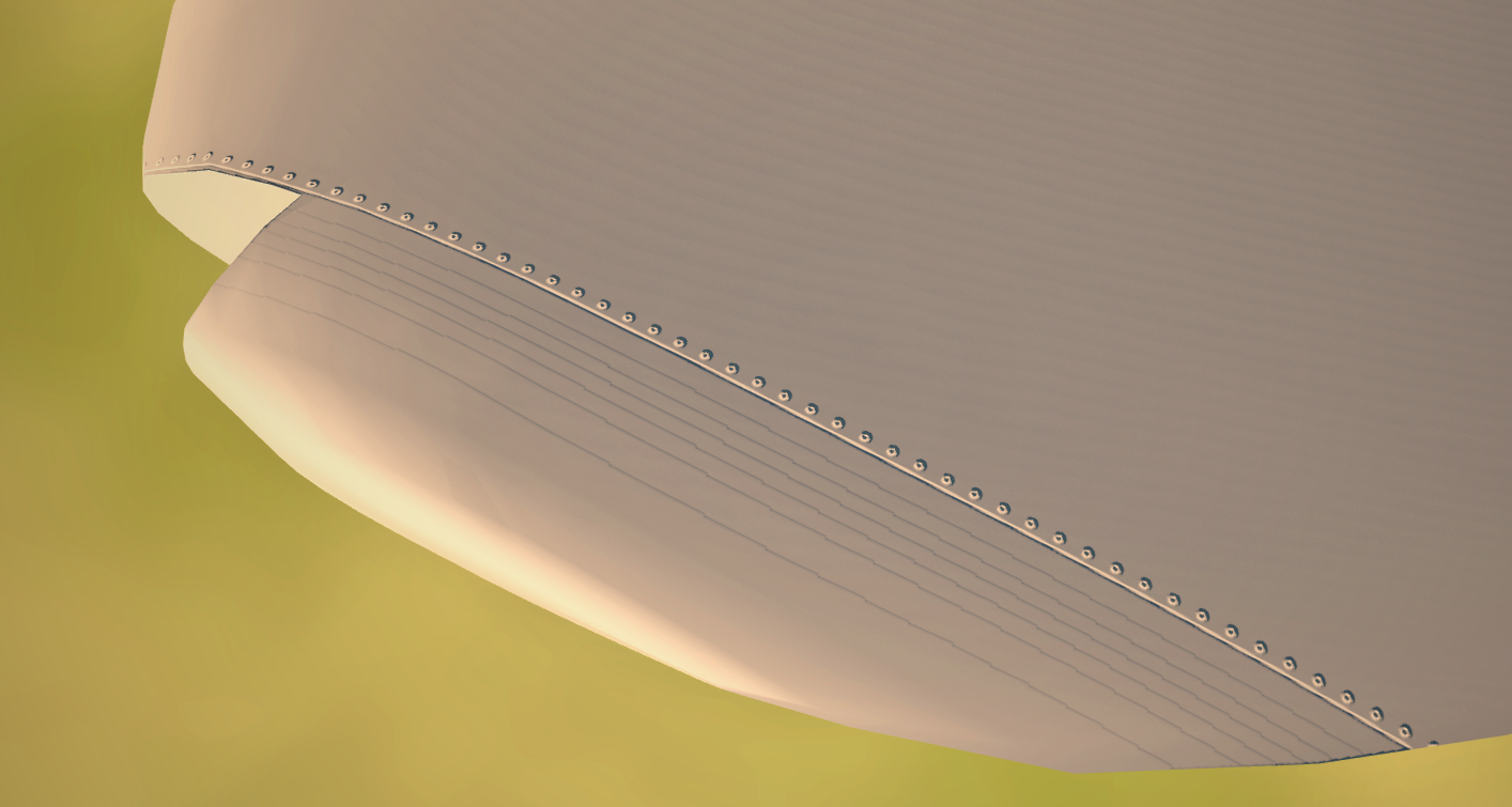
Texturing on the wing starts, testing a technique to get the overlapping effect of the sheet metal. Working on a 8k texture per wing that gives us approx 5.551 pixels per centimetre which sounds like a lot until you realise a standard rivet it about 3/16" or 0.47cm giving us about 2 pixels to rivet with Theres banding on the gradient here with the way I exported the height map from photoshop but its enough to demonstrate how a pop rivet would look
4 points
-
This is unfortunately one of the problems of a pixel dot based solution. The dot will always be the same size, and have the same fade rules regardless of the size of the object under it. However, I do think it's fixable. If an object size was passed into the shader, then the fade distances could be pushed in/out accordingly. This would solve the problem of large aircraft such as C-17s and E-3s being invisible from distances they shouldn't be, and smaller objects such as missile being too easy to see at too far a distance.4 points
-
We can suggest it to the team, but can make no promises4 points
-
If you have better public data than we do please PM me we are always happy to re-evaluate what we have. thank you4 points
-
Worked on, how? I think it's pretty clear from this thread and the poll so far that most think this is at least a step in the right direction. It doesn't give anyone an unfair advantage. Why would you want to make sure the IC picks it up unless/until you guys have a solution? I love this sim. I love the visual fidelity that it's capable of - and I play for immersion. Almost everything I've done to upgrade my PC/setup is purely to make the game look better - and users like myself suffer when doing MP because whether an opponent is running a potato, or just sandbagging their settings - they get a very clear advantage over me for spotting. I've only just recently started flying warbirds, but I can't tell you how many times I've had friends running 1080 or lower call out contacts that they can very clearly see that don't even show up to me because I'm running 2k. As many others have pointed out, it's the worst part of flying warbirds and it's something that quite literally everyone I've spoken to about mentions as being "completely borked." Everyone on the servers says "gotta turn your resolution down." ...it shouldn't be that way. It's no different than the FPS players that used to turn their settings all the way down so they could see people in grass and bushes and stuff. I'm not trying to rake you guys over the coals...but c'mon.4 points
-
I can't say this enough but thank you for everything you do. I don't know what else you may have on your agenda given how much life you've brought into the DCS naval and ground combat scene, but might I interest you in the LD-2000 and LD-3000 weapon systems? The People's Liberation Army Ground Forces have built and deployed rotary cannon-based C-RAM weapon systems derived from the CIWS systems found aboard People's Liberation Navy surface combatants like the Type 052D, Type 055, and Type 054A, among others. Something like this would be very interesting as future additions whenever you have the necessary resources and have gathered enough intel.4 points
-
What is it? This mod aims to address two specific issues with the current implementation of contact dots in DCS: Dot size is always one pixel, which means smaller dots at higher resolutions, and that the lower your resolution, the easier it is to find contacts. Dots are rendered too far. As long as an objects model is not culled, it will get a dot drawn on it. DCS' draw distances can go out to >40 miles, making it possible to see the dots of an aircraft before even your radar can pick it up. This is accomplished by adding these new rules to how dots are rendered: The size of the dot gets bigger with screen resolution, using the reference resolution of 1920x1080. The dot becomes fully opaque at distance of ~6 miles. The dot is completely transparent at a distance of ~18 miles. When between those two extremes, the dot will fade at an exponential rate. Download The mod is available on the DCS user files here: https://www.digitalcombatsimulator.com/en/files/3330454/ How to install Unpack the "Bazar" folder in your DCS World root directory. This will overwrite the "dots.fx" file. By default, this is located in "C:\Program Files\Eagle Dynamics\DCS World". As of the May 18 2.8.5.40170 openbeta patch, this NO LONGER PASSES IC. FAQ So what does this actually mean? 1. It means that dots are no longer visible from extreme ranges. You won't see planes 20-50 miles away. 2. Playing a high resolution (in this mod, defined as a screen height of >1080) you should have roughly the same "dot acuity" as somebody playing at 1920x1080. This corrects the common practice in DCS of people reducing their resolution to make the dots bigger. Are ground vehicles easier to see? Generally, no. At high resolutions, the dots become rectangles, since half the 2x2 dot is now under the ground. The dot also fades with distance the same as aircraft (the shader can't tell the difference), so you won't be able to spot vehicles from 30 miles like you could before. Why did you pick the ranges you did? Experimentally gathered data, from a paper that is infamous on this forum and won't be named, found that T-38s were spotted around 4-6 miles, depending on conditions. Knowing where the target already is can boost this detection distance by about 5 miles. Based on that information, I tweaked the opacity values and formula such that I was able to consistently find a dot around 4-6 miles, and could find and track distant dots (which are faded to ~50% transparency by this point) at around 10 miles, when I already knew where to look. Are dots completely invisible past 10 miles? Not completely invisible, but they are extremely faint. You'd have to already know they were there to find them, and they are very easy to lose. By about 15 miles they are basically impossible to see. Do I need to turn on labels to use this? No, the dot system in DCS is completely independent of labels. There is some confusion around the label system having a couple "dot" settings, but what those do is draw a label with a little . over the target. Labels are (at present) not obscured by clouds or the cockpit frame. The dots in DCS meanwhile are a completely separate function and do not interact with the label system at all. They are always on, cannot be turned off, and cannot be modified by players without messing with the shader itself as this mod does. To eliminate the chance of confusing labels with the dots, I recommend turning off labels completely when testing this mod. What makes 1080p special? In my experience, the dot size at 1080p resolutions is big enough to be useful, but not so big that it becomes distracting and strange looking. Therefore it was chosen as the reference resolution for which I wanted higher resolutions to have parity with. Does this mod do anything if I already play at 1080p? The only difference you'll notice is that contact dots fade away as they get further. Does this mod work on ultrawide? Yes. The only thing the mod takes into account for sizing the dots is the vertical resolution. Does this mod address the ability to see dots through clouds? No. I did make a brief attempt to see if I could fix that, but it's likely something that Eagle Dynamics will have to fix themselves the correct way. If I zoom into a dot that's far away, does that cause it to fade in? No, the dot opacity is based on a hard distance calculation. FOV has no effect on the opacity of dots. Does this mod address the exploit of raising the FOV to max in order to enlarge dots? It does not. The old impostor mod I made many years ago did this, but I wanted to keep this mod as simple as possible. I might add it in later if there is demand. As with the impostor mod, I'd likely just fade the dots over some field of view. What happens if I play at a resolution under 1080p? Dots will still increase in apparent size at resolutions lower than 1080. Initially I wanted to either try and make the dots "subpixel" by rendering them appropriately smaller at low resolutions, but this isn't feasible without engine changes. I also tried fading the dots proportionally when under the reference resolution, but this created problems with flickering models. The biggest advantage that low resolutions used to give was seeing dots from tens of miles away. Since the dots are now guaranteed to fade with distance, I figured it was best to just let the low resolutions keep their slightly larger dots. Why can I see missiles now? Unfortunately the only information I have to work with in the shader is the object's position. The shader is completely unaware of the model that is under it, so all the logic applies equally to all visible objects, regardless of their size. For objects larger than the average fighter, this works itself out and isn't an issue. However for smaller than average objects such as missiles, this can look a bit strange. Fixing this requires Eagle Dynamics to provide more information to the shader such as an object size. Does this mod pass IC? As of the May 18 2.8.5.40170 openbeta patch, this no longer passes IC. Update v1.1 See the below link for more information.
3 points
-
Using fade as a second variable to fine-tune visibility does seem the obvious solution, and shouldn't be hard for them to implement. Seems like ED has pretty much been served a fix to a major shortcoming of their simulation on a silver platter here -- hopefully they choose to partake.3 points
-
This is a great suggestion. The pattern is already in there (with Realistic TDC Depress). It's clear, customizable, and should be a straight forward implementation. Tucked away under "Special", it won't clutter up the controls page nor require additional bindings. Each screen should simply multiply the slewing speed by whatever the user has set in there. As neither the community nor ED (and to be honest probably not even 99% of real life Hornet pilots) know the relation in speed between different screens in the real aircraft, and we all have different hardware, it makes a lot of sense to leave it to the player to fine tune it. @BIGNEWY@NineLine3 points
-
I do 100% single player and 100% open beta. There is no issue, if there is a bug that affects my fav module, I use another module for the time being or if let's say Hornet A2A was bugged, I focused on traps and A2G .... That way: 1. I am "not affected" by bugs, 2. Benefit from latest changes, 3. Have a chance to find and report bugs to make the product better when those get resolved.3 points
-
thank you3 points
-
I just created an easier to use web page, not perfect yet, but maybe easier to use: https://simshaker-for-aviators.github.io/SimShaker-for-Aviators-Releases/ I've currently some family related issues which need my attentions thus I'm a bit quite...3 points
-
I assumed we were heading that way, no, no BMS is a game and we are not modelling another game. We cannot verify anything in that any more than we can on any other game. We are doing our best to model the real-world aircraft without Frankensteining it too much, or guessing, assuming to fill in gaps. BMS, War Thunder, etc etc all have set their level of simulation, they set the limits they are willing to go, the limits they are willing to fill in here or arcade there, we have our own rules we live by. You continue to insult instead of being able to provide real evidence, even a real-world SME comes on and tries to give some insight without stepping over the line it's met with disbelief or just plain ignored. So looking at the last few posts I see we are not going anywhere, you are all convinced based on your own "common sense" so I will leave this thread as it is. If you have definitive proof of your beliefs you can send them to us via PM, the source must be valid and legal. At this point I am closing this thread, if someone does come back with some valid info I will reopen it and let everyone know. Thanks for your efforts so far, I know you are all passionate about creating the most realistic Viper possible, and so are we, sadly we have rules and guidelines to live by for what gets added and what does not. After all, you answered really your own concerns here: One last thing, the comparisons to the Ka-50 are a little silly for the very reasons you list. But we have people with deep knowledge of a great many things when it comes to this and we feel we gave users/customers something, in general, we would not be able to give, which is a fierce Ru attack Helo within the rules and laws we must abide by in each and every country around. We do appreciate the efforts here, but we are not getting anywhere new now. Our DMs are always open. Thanks The ED Team3 points
-
Let me reiterate that I’ve been doing this professionally for decades and that looking for traffic is something I do daily. Nevertheless as a result of this discussion I decided to test this today on my way back from Madrid. Crossing the North Atlantic at FL340 (34,000 feet), there was a fair amount of opposite direction traffic on the same route a few thousand above and below me. TCAS (Traffic Alert and Collision Avoidance System) would pick up the traffic at a distance of approximately 25-30nm, and inform me precisely where to look. At this altitude they were producing contrails. I could easily see the contrails at this distance but could not see the aircraft themselves until approximately 15nm despite the contrails making their location obvious. Later we climbed to FL380 and ultimately FL400 over the Canadian maritimes. At this point traffic was not producing contrails. There where two large wide body aircraft shown on TCAS about 25 miles to the right, one at my altitude and one 2,000’ below. The sun was shining directly on these high-aspect, 260 foot long, 50 foot tall brilliant white aircraft silhouetted against a deep blue sky, and TCAS was directing me precisely where to look. After a minute or so of searching, I was able to see those aircraft, just barely. I found however, that despite the relatively small angular difference between them, if I looked at one aircraft I couldn’t see the other. I had to look in between them to see both. If I took my eyes of them, they where difficult to re-acquire. If TCAS hadn’t been directing me where to look, I would never in a million years have seen them from simply scanning the sky. Low-aspect traffic coming directly at me from the other direction could not be spotted until about 15 miles, again even though I knew exactly where to look. Once they where within 7-8nm, spotting was much easier and I simply had to look in that general direction of sky. Let me reiterate that these aircraft are about as long as a football field and painted brilliant white. And, at least according to my AME, I do have 20/20 vision. Now, imagine instead these aircraft where only 62’ long (the length of an F-14 Tomcat) and painted matte gray. Or, for another thought experiment, imagine standing on top of the Empire State Building (1250’/380m tall) and spotting a die-cast model of an F-14 Tomcat 4.7 inches in length sitting on the sidewalk. That is is being described when spotting an aircraft at 60km. Let me reiterate, *comical*.3 points
-
I dont remember one time where we had a delay on an actual release date and didn't state why there was an issue. We generally do not hype far ahead of time, we do share updates and things we feel our customers would find interesting, 9 times out of 10 its other users making the hype or suggesting dates not us. I would not have posted what I did if the map was not going to be released for another year. We dont give dates in general outlined clearly in your post why we dont.3 points
-
This seems reasonable to me.3 points
-
After reading the thread and some more experimentation there's a few comments I want to make. 1. I played a bit more with settings last night and noticed that the mod only works "as intended" when MSAA is enabled. I messed up the math somewhere, making the dots not perfectly pixel aligned. Without MSAA, the dots can flicker or appear smaller than they're intended to. This can probably be fixed easily by someone with a better understanding of the shaders. If I happen to find a solution to this I'll update the mod. 2. Based on feedback from VR users, the mod's effects are less predictable due to the wide amount of variance in VR optics and display technology. For VR, what matters most is the apparent pixel density, i.e. how many "pixels per degree" you get. On common headsets such as the Quest 2, the mod seems to be working as intended. However for more exotic and extremely high resolution headsets such as Varjo Aero, the mod doesn't do much since pixel density is so high that the 2D formula just doesn't work. On the bright side, headsets like this are at the extreme end of the spectrum of support and very much the exception. What this really exposes though, is the inherent limitation of a pixel based solution. I've said this elsewhere, but dots are really not a great solution to making visibility more realistic, especially in isolation. Dots scale best at low resolutions, and can be useful in creating hard and absolute limits to contact spotting. In my opinion, combining dots with some kind of scaling solution is a much better way to go, as you cover both bases. Scaling the visual models (or some simplified LOD) scales much better with higher resolutions and higher fidelity graphics options, since the actual geometry is still there. Dots meanwhile scale better with low resolutions, and combination of the two means the dots will cover lower resolutions, while scaling covers higher resolutions. 3. There's been some discussion on if the ~10 miles spotting distance is too short. Especially enlightening about this conversation is the comment, "I can see the ISS". I've already stated in the OP why I chose the numbers I did, but I want to expand on that rationale. TL;DR: the numbers are based on the distances at which you should be able to consistently spot fighter sized targets. There are absolutely certain circumstances in which it's possible to see small aircraft from extreme distances. The most common example of this is when the sun glints off something on the plane. The human eye is very sensitive to these sorts of "hot spots." It's why you can see illuminated streetlights and traffic lights from much further than you can make out the actual light/lens assembly itself, why you can see stars and planets in the night sky, and why when a plane catches the sun just right, it appears a bright speck of light despite being tens of miles away. There are some older sims which tried to emulate this idea. I'd give more specific examples but AFAIK that's a bannable offense. Regardless, I think it'd be nice to work out a sensible way to make sun glinting work. I did briefly experiment with this, but I couldn't get it working in a way I thought looked nice, and you also have to be careful to make it somehow never apply to ground units, which is difficult because the shader has no knowledge of the object under it.3 points
-
Sounds like DCS needs to nerf the guys using 2d monitors then. 60km spotting distance is comical. I found this on Hoggit: Several investigations have been made to determine aircraft target acquisition capabilities. A total of 759 training engagements at the Naval Air Station Oceana Tactical Air Combat Training System (TACTS) range revealed that in 624 of the engagements the pilots first sighted the target as a dot against the background at an average distance of 5.67 nmi (Hamilton & Monaco, 1986; Monaco & Hamilton, 1985). In the remaining 135 engagements exhaust smoke, contrails and sun glint off the aircraft allowed the pilots to detect the aircraft at even greater distances. In the 122 engagements where exhaust smoke was the primary cue, detection distances averaged 7.64 nmi. Environmental and local conditions as well as target type and paint scheme play a significant role in detection distances though. Variables such as background sky or ground coloring vs. aircraft coloring, brightness and directness of sunlight as well as target location vs. the sun and several other variables can either enhance or decrease detection distances. Furthermore, although Hamilton & Monaco found several instances where exhaust smoke was the primary cue, this condition is arguably becoming of decreasing value as aircraft emissions have become less visible over the last decade or two. Table 1 provides a large list of factors that have been shown to affect target detectability. These items were taken from the field evaluations cited in this section as well as Bloomfield & Smith (1982), Boff & Lincoln (1998), Buffett (1986), Costanza, Stacey, & Snyder (1980), and Hoffman (1976). In 1983, Kress & Brictson studied 87 air-to-air engagements at the Yuma TACTS range. Average unaided detection distances for the target F-5 and F-4 aircraft were 3.1 nmi. When the pilots were aided with a head-up display (HUD) symbol that cued the pilot to the target’s location, the mean detection distance grew to 6.8 nmi. Another study that investigated detection distances was Temme & Still (1991). They measured air-to-air target detection distances at the Naval Air Station Oceana TACTS range to see if there was a performance difference between those pilots who wore corrective eyeglasses and those who did not. Those with eyeglasses did not detect the targets until they were about 10% closer than those with unaided vision. Two very closely matched groups of eyeglass and non-eyeglass wearers had average detection ranges of 4.52 and 5.64 nmi respectively when using all detection means including aircraft sighting, target glint, contrails and exhaust smoke. When limiting subjects to aircraft-only detections, the corresponding distances were 4.35 and 5.54 nmi respectively. Although the distinction of glasses vs. no glasses is not of interest to this investigation, it does provide two more data points for detection distance ability. Another study by Hutchins in 1978 at the Air Combat Maneuvering Range (ACMR), which is the earlier name of the TACTS, involved 45 air combat training engagements. The mean detection distance of the A-4 targets was 3.09, with a range of 0.38 to 6.23 nmi. Other studies were done using observers on the ground. With visibility conditions spanning 7 to 10 miles over an 8-day testing period, O’Neal & Miller (1998) found detection distances for approaching T-38 aircraft to ranged from 4.77 to 6.73 nmi. Another ground observer study used 400 visual detections of a T-38 aircraft (Provines, Rahe, Block, Pena, & Tredici, 1983). The aircraft was approaching from a known direction and a distance of 9 miles and mean detection distance was 4.55 miles over the 400 trials. References Hamilton, P. V., Monaco, W. A. (1986). Improving air-to-air target detection. Wings of Gold, 46-48. Kress, G., Brictson, C. A. (1983). Operational Analysis of Visual Skills for Air Combat Maneuvering (NAVTRAEQUIPCEN 80-D-0011/041-3). Orlando, FL: Code N712, Naval Training Equipment Center. Hutchins, Jr., C. W. (1978). The Relationship between Air Combat Maneuvering Range (ACMR) Output Measures and Initial Visual Acquisition Performance (NAMRLSR-79-1, AD-A062 134). Naval Air Station, Pensacola, FL: Naval Aerospace Medical Research Laboratory. Provines, W. F., Rahe, A. J., Block, M. G., Pena, T., Tredici, T. J. (1983). Yellow Ophthalmic Filters in the Visual Acquisition of Aircraft (USAFSAM-TR-83-46, AD-A138 536). Brooks AFB, TX: Aerospace Medical Division, USAF School of Aerospace Medicine3 points
-
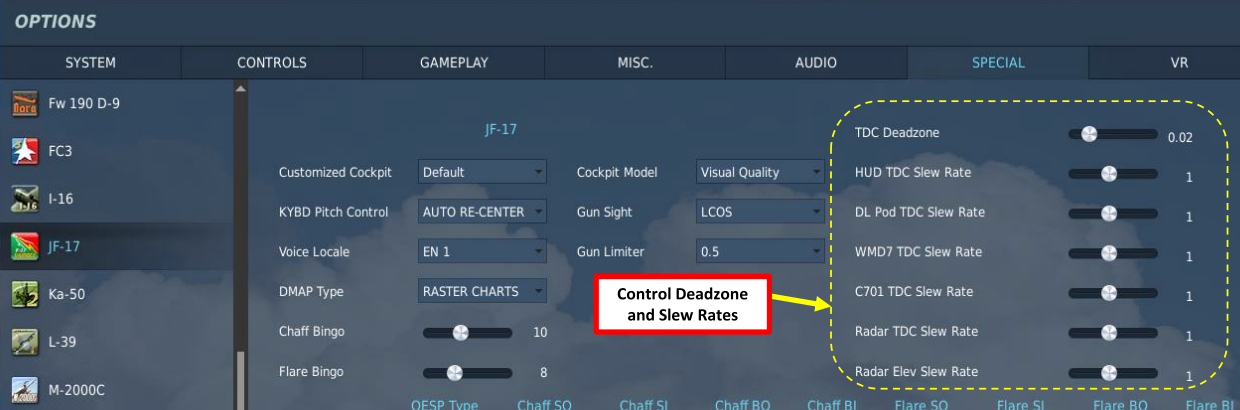
In my mind the ideal solution from a user experience standpoint would be to have a series of sliders in the special options to adjust the TDC sensitivity on all formats: HUD ATTK AZEL SA HSI TPOD GRID Because although the new speed does make it easier to do things like bump ranging on the ATTK format, its going to be absolute hell to try and enter MGRS with it, at least unless you have a force transducer for your slew control. It seems that instead of trying to cater for all controllers and ending up with a one size fits none solution, ED should just let the player decide what they want, especially when it comes to issues like this that are wholly dependent on hardware being used.3 points
-
I'll check out the mod, we can put it forth to the team even as an option if everyone things it is worthwhile. Thanks! PS I added a poll on here, if you have tried it, please vote. Thanks.3 points
-
As mentioned we are happy with the information that we had for the change. we have passed on the feedback from here to the team from this thread. I have removed the image above please keep it DCS related here. thank you.2 points
-
You completely missed @Hulkbust44's point. The maltese cross (indicating the radar is not emitting) was always there, but because of how cameras and CRT displays work, it appeared as if it wasn't there. Look at it again, pretty much all the symbology wasn't there until it quickly faded in. That is something often seen in videos of CRT monitors, including a lot of real life cockpit videos.2 points
-
Ward Carroll's channel2 points
-
Once Normandy 2 is released expect a lot of new people joining WWII DCS, we can already see it on the forums in DCS lots of new to warbirds pilots and in other games forums lots of people wanting to get into WWII DCS when they see this new map. When I see complaints about DCS WWII in other forums its mostly about the plane set, what I would say what makes it a problem in that respect is the map set, not the plane set, if we had a map of Germany no one would say is not a historical. Still DCS WII they way we have it right now, is way better than any other product out there, and its just getting better.2 points
-
Hello, tank you. Printing parameters are selected individually. You need to practice to get a good result. The main body I print with abs or pla, for white mark petg. Buttons for A-10 in the process of testing. Button body printed with white pla. Painted with acrylic model paint gunze sangyo.2 points
-
Wasnt the "surprising" agility mostly compared to other interceptor aircraft like pre-slats F-4 phantoms? The Mig-21 was quite agile for an early cold war interceptor design, and that seems to be mirrored in the DCS Mig-21. Turns better than a Mirage-F1 in DCS (if that didnt change), or the later Mig-23. Its still not a dogfighter and cant turn like an F-5, which IIRC soviets even commented on as an aircraft that would be very difficult to fight for them. Tbh, maybe im just too casual, but when I recently tried the Mig-21, I didnt see a dealbreaker. Sure, the gunsight is too powerful, the radar is too reliable, maybe some systems arent exactly like they should. The RWR seemed fine, but its hard to tell, since its not very useful anyway. In general though the Mig-21 delivered a great flying experience, it had a lot of interesting if primitive systems built in, and is one of the things that made me excited for more early to mid cold war planes like the F-4E.2 points
-
Just chiming in here.... I was flying the Apache for the first time after a long time yesterday - and had the same issue.... However, I quickly realised that my pedal input was all over the place. What we did, was flying a couple of different Helis in SA. On its own and in comparison - the sensitivity of the Apache to the pedals seemed a bit off to me. Each small Pedal input would make the ball jump from left to right and vice versa, I was barely able to keep it centered. (15% Curve and 70% saturation on the input axis) I don't claim for a second, that the problem can't be me though. Maybe I'm missing something.....2 points
-
remove the first stage. You want it to fire when you squeeze the trigger completely, the first stage would start the gun camera rolling.2 points
-
This phenomenon doesn’t have so much to do with 2D vs VR but resolution. Lower res pixels are larger and therefore a contact rendered as a single pixel will be a larger dot at low resolutions. VR tends to run high levels of pixel density. You aren’t the first person to discover this, the topic is frequently discussed. Alas there probably isn’t a good solution. The use of icons and labels in these games has convinced many players that small distant aircraft should be easily visible which clearly isn’t reality.2 points
-
Updated for DCS 2.8.4.38947 as of 4/13/23 including additions by @currenthill for all of his awesome assets.2 points
-
Honestly both size and range would be good things to have tweakable server side if ED IC locks this. Honestly if ED is smart, letting users and MP server owners control this sort of thing is the best way to go. It basically gets the community off their back cuz you can set it to what "you" feel is realistic. Yay no more flame wars. You can have some "default" that ED thinks is right as well but if people don't like, presto change-o.2 points
-
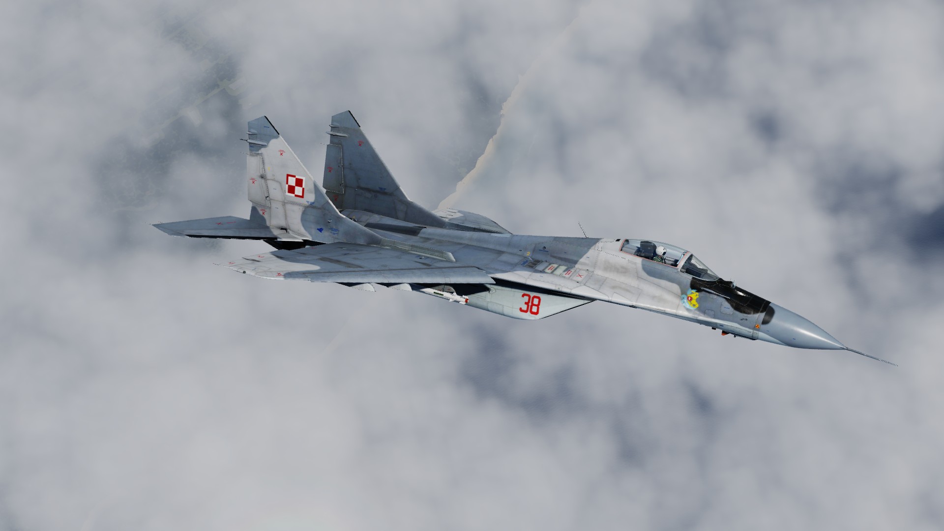
Number 38 is avillaible now: https://www.digitalcombatsimulator.com/en/files/3330470/
2 points
-
Missiles from earlier than the R-27 were already deconflicted in channels, and it was necessary to do in order to guide more than one missile to the same target either from the same aircraft or multiple aircraft. There are very clear sources for how that is done for the R-27 (you're welcome to search for them in the Russian forums, I'm sure there are also some posts in the English section about it as well), and it has nothing to do with TWS. The very mechanism of this guidance signal injection is also how the RWR can know the difference between STT and 'guiding'. The same applies to sparrows, and pretty much any early 70's and later SARH. If the STT track is completely lost (excausted mem mode etc), the radar will move on to using the next missile guidance channel and the missile in flight is lost. If the STT track is not lost (mem mode operational, lock recovered) and the missile fails to continue guiding in a situation where it should be able to reacquire then that is a bug.2 points
-
I’m a professional pilot with well over 10,000 flight hours and I can tell you that IRL it’s damn hard to spot a wide body airliner at 16km. If people are using mods to spot at 60km in DCS then they are basically cheating as far as I’m concerned.2 points
-
Please make the slew rate speed adjustable. Some slider on special options and such would be great. The lower value could be the previous values, the maximum or near maximum would be the current. So it would let the user to decide the ergonomics accordingly with their hardware just like the realistic Maverick slew having to depress TDC and many other options on special tabs across multiple modules. It is not really an aid as you'll lose slew speed across the screen so efficiency wise wouldn't be overpowered and wouldn't affect the simulator's realistic approach.2 points
-
Looks like it's related to ground position shift of P-47 during last patch. I blew up just doing circles over AF. Just "touch and go", so it can't be related to battle damage. @Edit:2 points


-
Recently Browsing 0 members
- No registered users viewing this page.