Leaderboard
.thumb.jpeg.b9a38a8127c434fd6eba974eb2776d00.jpeg)

Popular Content
Showing content with the highest reputation on 10/10/22 in all areas
-
13 points
-
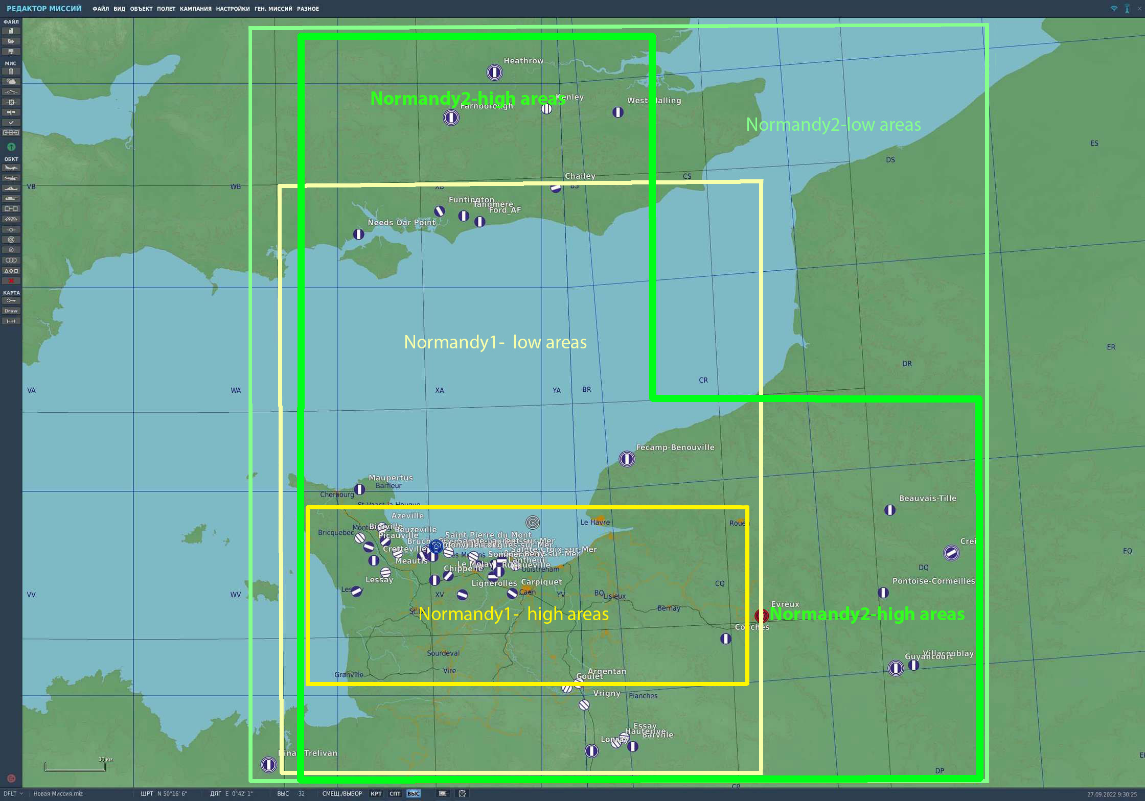
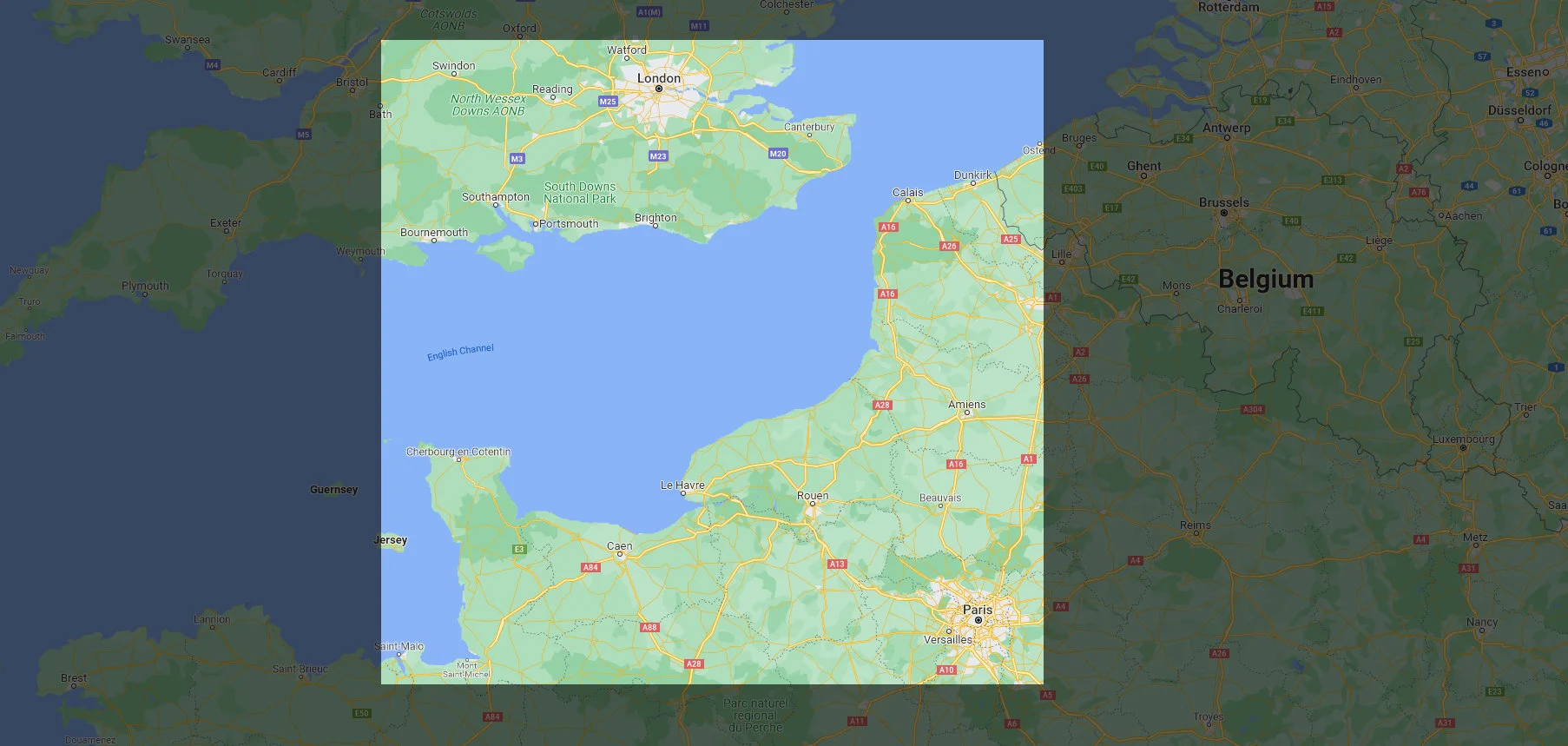
Hi! We have seen your questions and will try to answer them. When will it release? The intent is to release into Early Access before the end of 2022. However, this may extend into early 2023 based on testing results. How much will it cost? DCS: Normandy 2 will be available as a complete map for $59.99 USD with 20% off while in Early Access. If you have either DCS: Normandy 1944 or DCS: The Channel maps, you can purchase Normandy 2 for $14.99 USD. If you own both, you can purchase DCS: Normandy 2 for only $9.99 USD. How big is the Normandy 2.0 map compared to the Normandy 1944 map? Please see the attached image that illustrates the low and high detail areas of the Normandy 2.0 map compared to the existing Normandy 1944 map. The Normandy 2.0 map will be 400x600 km, which will make it significantly larger than the Normandy 1944 map. Is this a combining the Normandy 1944 and Channel maps? No, this is an all-new map that covers all the same area as the Normandy 1944 map, plus an extensive expansion that also covers large parts of the same area included in the Channel map. What new cities and landmarks have been added? Chief of among them are London and Paris, but it will also include many new medium to small size urban areas that make up the greatly expanded area. This will also include new ports, airfields, factories, rivers, canals, and more. Most of the Normandy 1944 map objects have also been greatly improved like buildings, bridges, airfield objects, rail lines, roads, trees, fences, poles, and more. What airfields will be included at release? The total number of airfields has bee increases to 50 for the Early Access version. This may further increase after Early Access release. Please see the attached map for a listing of the initial airfields. Am I paying for the same map twice? No, this is a new map, not an upgrade to the existing Normandy 1944 map. Although the Normandy 2.0 map includes the same area covered in the Normandy 1944 map, it is much larger with greater detail, accuracy, texture resolution, and trees. Because the Normandy 1944 map was created using older map technology and tools, it is not possible to simply expand the size of that existing map. The Normandy 2.0 map has been created with new map technology and tools that has allowed us to greatly increase the map size and amount of detail. Because they are different maps, all existing missions and campaigns created for the Normandy 1944 and the Channel maps will continue to function on those maps, nothing changes. However, missions created for the Normandy 1944 map would not work in the Normandy 2.0 map. As such, the Normandy 1944 and Channel map will continue to be for sale. If I only own the Normandy 1944 Map, will I be able to join servers running the Normandy 2.0 map? Yes, but detail areas included in the Normandy 2.0 map and not in the Normandy 1944 map would be at low detail and missing world objects. This item is still being worked on and may change. Will the framerates be worse than the current Normandy 1944 map? Using the latest Terrain Development Kit (TDK), we have optimized Normandy 2.0, despite an increase in the number of objects. You should see no loss in performance compared to the Normandy 1944 map. Will there be winter textures? We plan for the Normandy 2.0 to only include the summer season as it is being created around operations in Normandy in the summer of 1944 (Opération Neptune). What airfields are there in Normandy 2.0 Airfields in France A1 Saint Pierre du Mont A2 Cricqueville-en-Bessin B17 Carpiquet A12 Lignerolles A14 Cretteville A15 Maupertus A16 Brucheville A20 Lessay - оригинальны A3 Cardonville A4 Deux Jumeaux A5 Chippelle A7 Azeville B9 Lantheuil A17 Meautis A21 Sainte-Laurent-sur-Mer A24 Biniville A6 Beuzeville A8 Picauville A9 Le Molay B11 Longues-sur-Mer B2 Bazenville B3 Sainte-Croix-sur-Mer B4 Beny-sur-Mer B7 Rucqueville B8 Sommervieu Beauvais-Tille Cormeilles-en-Vexin Dinan-Trelivan Fecamp_Benouville Evreux Guyancourt Villacoublay Saint-Andre de l Eure Orly Amiens_Glisy Argentan Avranches Le Val-Saint-Pere Barville Conches Creil Deauville Essay Flers Goulet Hauterive Lonrai Poix Ronai Rouen-Boos Saint-Aubin Triqueville Vrigny Broglie Beaumont-le-Roger Bernay Saint Martin Airfields in UK Chailey Farnborough Ford Funtington Gravesend Heathrow Kenley Needs Oar Point Tangmere West Malling Deanland Friston Lymington Odiham Stoney Cross
 12 points
 -
Kevin Bacon just called, sending tremors across the team.8 points
-
Hi @MAESTR0, Thanks for the FAQ, I have a small question .. will the internal dcs map coordinates be the same as on the prior Normandy 1944, I mean the same coordinate origin and coordinate scales? I ask, because if the internal map coordinates are the same, it would then be relatively easy to adapt my prior missions to the new map, I would only need to edit the ["theatre"] = "Normandy", mission sentence, and all mission objects would already be on the correct place. Best regards, and I will still purchase the map even if its coordinates are not the same (because of the very very reasonable upgrade price )6 points
-
Yes. Full-size, manned helicopters differ greatly compared to R/C models, in a lot more ways than I suspect you realize. The comparison of the two isn't even close, not even in the same ballpark. But if you think that teaching anyone to fly an R/C helicopter is anything like teaching someone to fly a real helicopter, you are quite mistaken. (And yes, I've flown RC helicopters as well) I fly with a Saitek X52 and Saitek rudder pedals, no expensive set up here. Additionally, I have been playing flight sim games for decades as well (as has @bradmick), so we are fully aware of the differences between real helicopters, professional simulators, and desktop flight sim games. Further, equating force trim to "automation" is a false premise. The AH-64D's force trim is not a crutch or "an easy way out", it is a key components of the pilot-machine interface of the AH-64D. This isn't a Huey, or an R/C helicopter, there is more to flying the AH-64D than wiggling the sticks. I've noticed a common thread as of late, in that several demographics of forum-goers: helicopter mechanics, crew chiefs, engineers, and in this case an R/C helicopter operator, all are of the opinion that they are more qualified to comment on the accuracy of the AH-64's flight model than those that have spent thousands of hours and years of their lives flying the real AH-64D (not every person in those demographics, just that at least one person from each has commented as such). I mean no disrespect to you or your own experiences (or the experiences of others that work on or with rotorcraft), but such assumptions are silly. In your very own words, "you can study helicopter theory for 20 years, when you finally get in the seat, you'll still be a novice like anyone else". If you truly believe this, lacking first-hand knowledge doing the very thing that the DCS: AH-64D is simulating, which is being a crewmember in an AH-64D, how can you possibly assess the accuracy of the experience or the relevance of its flight control systems better than someone that has actually flown the real AH-64D? Again, I mean no disrespect, you are entitled to your opinion. But as someone that has seen both sides of the coin, as a helicopter mechanic and a pilot, not to mention played all sorts of flight sim games in the past 30 years, I'm telling you that your assertions are off the mark in these regards.6 points
-
We have our hand full at the moment with multi threading integration, the team want to get our current core work completed. We have made a request, but can make no promises at the moment. thanks6 points
-
This was interesting to watch, however I do want to clarify a few items. 1) Respectfully, recommending to players that they do not use force trim in the DCS AH-64D is the opposite of what they should be doing. Depressing the Force Trim Release switch isn't simply a method for the pilot to make the flying easier, it's how the AH-64 pilot communicates to the Flight Management Computer the pilot's intent for maneuvering. 95% of the time in which I am moving the controls, I'm pressing the force trim and then releasing when I'm done moving them. The force trim in the AH-64D is not meant to be treated as an optional device that the pilot can decide not to use. I mean, they don't have to, but it interacts with many aspects of the FMC in which the behavior of the AH-64D is affected, and not using the FMC will undoubtedly cause more issues with expectations of behavior. 2) I am unsure what the meaning is that hovering in ground effect is not "experiencing a true hover". From a pilot's perspective in a 7-ton AH-64D, the only difference between an IGE hover and an OGE hover is that the OGE hover requires more engine power to maintain altitude from the increased induced flow through the rotor system. Personally, I find it easier to practice hovering close to the ground in DCS because you can detect the deviations of the helicopter's position when you are closer to the ground, and since small movements will be more apparent. The control touch required to hover a helicopter is just as difficult at 80 feet as it is at 5 feet, but in the simulator it can be more difficult detecting deviations when hovering at 80 feet since you are limited to visual feedback, due to the lack of detections of inertial movements from the inner ear and proprioceptive feedback. 3) While there are some needed improvements to the AH-64D's autorotational behavior, and these will undoubtedly occur as the flight model is refined, there seems to be a misunderstanding in how much inertia the AH-64's rotor system should have. Some helicopters like the UH-1 Huey have a "high inertia" rotor system in which the rotors have enough momentum to keep their RPMs from slowing when exposed to drag during an autorotational deceleration, allowing you to maintain a momentary hover at the bottom of an autorotation. However, the AH-64 has a "low inertia" rotor system in which the rotors can spool down quite rapidly at the bottom of an autorotational descent to landing when the collective is increased to decelerate and cushion the descent for touchdown. Attempting to hover at the bottom of an autorotation in a real AH-64 would be foolhardy, as it should be in DCS: AH-64D. Additionally, a turn at the bottom of an autorotation to perform a tail-up flare would be tantamount to an airshow stunt, or something only performed in DCS, so I just want to clarify that such an attempt in real-life wouldn't ever be intentionally attempted during an autorotation, as it would most likely result in death to the crew. I wasn't sure if that was intended as a DCS-only challenge, or as a comment about something that should easily be performed in real-life, but it's not a thing for the AH-64D. However, overall, thank you for the feedback. I hope you'll appreciate the continued improvements to the flight model that will occur throughout the Early Access process. Respectfully, Raptor6 points
-
Shame about the campaigns and winter textures, I'll still get the map, but was looking forward to playing reflected's Normandy campaigns on the new map.5 points
-
This thread is a mess, guys, please don't trash threads with insults, attacks and flying OT so far... I am closing this one. Thanks5 points
-
Happy Sunday and or Monday for some!! I'm releasing the updated version 1.1.0 of the Russian Frigate Admiral Kasatonov. Highlights are below which iron out all the features that have been updated. The updated version has also been posted on page #1 of the forum! Here's the changelog: Admiral Kasatonov - Admiral Gorshkov Class Frigate By Admiral189 and Currenthill Version 1.1.0 - Fixed left propeller orientation - Fixed both propellers animations - Changed 9M96M to enhanced warhead - Changed ship's wake effect - Changed 9M100 ECM resistance to -1 - Changed 9M96M thrust vector performance to 25 - Changed 9M100 thrust vector performance to 25 - Changed 9M100 to enhanced warhead - Changed 9M96M to max altitude 30 000 m - Changed 9M96M kill distance to 15 m - Changed 9M100 to 140 kg - Changed 9M96M to max range 150 km - Changed 9M96M/9M100 to salvo interval 0.2 - Changed 9M96M to max 20 G - Changed 3M14T range to 800 km - Changed Palash AO-18K dispersion - Added Palash AO-18K reload - Changed air weapon distance marker to 150 km - Fixed wrong 3M14T texture size - Added additional hull number liveries - Changed size of Palash AO-18K muzzle flames https://ln5.sync.com/dl/3157fd800/dsuysp6f-4qr4fk88-ytujxhdb-mewcv3hq/view/default/117807819400075 points
-
DCS WW2 multiplayer is alive and kicking. Could be busier, as always, but that's not the purpose of this thread and I'm not about to continue derailing it. Some questions: When will we know if the old Normandy and Normandy v2 are cross-compatible? The original post is contradictory. Either missions created for Normandy v1 will work on Normandy v2 or they won't - at the moment this must include multiplayer as there's no difference in the miz file between a single player mission and multiplayer (except for official campaigns) Project Overlord, the 4YA WW2 mission design team, has large amounts of historical reference material about the air power component of Operation Neptune and the German response to it which we've put together as we build our missions. Can we share any of this with you to assist? What's with the airfield choices? Heathrow, Farnborough? Perhaps some USAAF airfields in England would be good to add instead of a private company's test airfield (as Heathrow was in 1944 - Fairey Aviation's all-grass factory airfield) and an experimental base (Farnborough). For the USAAF bases I'd suggest Stoney Cross and Hurn: Hurn still exists today (Bournemouth International (!) Airport) and Stoney Cross's runway layout still exists even though the site has been derelict for years.4 points
-
This thread isn't about responding to your many criticisms, this is a FAQ thread about this new map, please stay on topic.4 points
-
Will there be beacons and airfield lighting to allow for night ops?4 points
-
There will be a FAQ posted soon showing more info about the area covered. thanks4 points
-
Horizontal offset cannot be supported without the game providing additional information about left/right view rendering. The effort required on my end to support it without this information is phenomenal. This isn't an OpenXR thing: the way FFR is implemented is 100% unrelated to OpenXR. The issue you have here is exactly the same issue that vrperfkit has. There is a thread here where all that's needed from DCS is outlined (and yes it would take them literally MINUTES to do it, while without this information it would take me WEEKS or MONTHS), however the developer has ignored this request since April: https://forum.dcs.world/topic/299598-trying-to-connect-the-individuals-that-made-the-performance-enhancement-in-vr-to-the-dcs-devs/4 points
-
A successful autoration in an Apache will see the rotor RPM at a point where the rotor system is incapable of lifting the helicotper off the ground again. As @Raptor9 stated, the rotor is extremely low inertia, a fact that catches real aviators off guard a lot when dual engin failures are trained in the simulator. The rotor will bleed off extremely fast if the collective isn't reduced immediately on recognition of the failure. It would also be helpful of content creators would stop saying 'don't use the force trim' without first qualifying the statement with 'unless the FMC SCAS channels are selected off". Because it completely ignores how massively important to the aircraft and the flight controls the force trim is. So if you're going to try and teach 'stick and rudder' flying, then say "turn off the FMC SCAS channels on the ENG, UTIL page because now the force trim no longer matters to the FMC." The exact reason why the Force Trim is important has been covered in exacting detail across the forums. Just requires a little research. The use of close in cues cannot be understated for learning fine motor control for the hover. OGE hovers are the absolutely worst place to learn to hover because you won't have enough close in detail to sense relative motion of the aircraft over the ground. I'm a big fan of a steady head position and scanning 'near rocks' (within say, 5 to 15 feet from the aircaft) and 'far rocks' (> 15ft to the horizon) in the hover. The steady head position is super important becuase now you've eliminated at least one variable in trying to figure out if the movement is the aircraft or your head. Just my thoughts.4 points
-
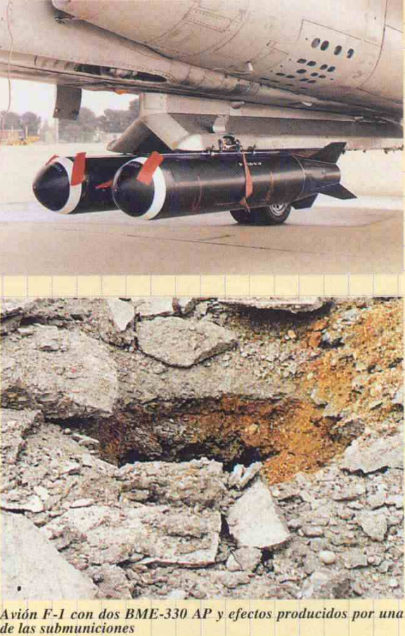
was wondering if we'll get to see the BME-330s, the retarded versions of the BR.250s and the BR series of bombs itself on the centerline CLB-4 rack in our DCS mirage F1, as they were used in this plane by the spanish airforce and i dont believe they've been mentioned in any upcoming weapons list some examples of them in this aircraft below BME-330 BRP/BRPS.250 BR series in CLB-4 rack (BRP.250s specifically in these pictures)
3 points
-
@MAESTR0 Will there be night lighting for London and Paris?3 points
-
@toutenglisse - I hereby nominate you for DCS Forum All-Star award! Sir, you are absolutely one of our most helpful members. Thanks for being awesome! I was just looking for how to do this very task in the ME. Thanks to this thread, I have it working in 5 minutes instead of the hours it would have taken to figure out the UNCONTROLLED check-box.
3 points
-
Would love to see a payware version with accurate systems (the possible non-classified ones)3 points
-
Amen! That's what makes all of this so smooth. If it was simply "too bad for you, buy the new one at full price" it would be a bit crunchy. But to get a bigger and better version with an 80% discount, I have no complaints at all. DCS is an expensive hobby, but with the free trials and the discounts, as with the upcoming BS3, I think you're right and it's very fair.3 points
-
It helps my poor SSD and Mission Generating, Campaigns and eventually Dynamic Campaigns, 1 Map Covering likely both area's + more, vs 2 maps splitting missions and campaign missions between the 2.3 points
-
You printed landing light too?!3 points
-
Are there any plans of implementing steerpoints 31-54 as LINES steerpoints? I'm running into some situations where drawing boxes on my HSD would be incredibly useful. Thanks!3 points
-
You can't reliably get a copilot/gunner in the other modules. You think you're going to get 10? You're literally going to need to have a clan dedicated to crewimg a single B-17 taking turns on who gets to be pilot. If you try to rando it... well... we all know how that would go. 3 guys join, ones a noob, the other two are trolls that jettison your bombs and shoot off all the ammo.3 points
-
Day one for me too. RAZBAM has had its share of hiccups, but I think they're pretty solid. I'm sure the F-15E will see a lot of fixes and updates.3 points
-
Because with the size stated above And including both London and Paris which we know are included in the Normandy 2.0 map, the area covers looks like this, which clearly covers the area in the channel map as well. Granted it remains to be seen if we are right or not, BUT I can’t see any other reason why ownership of the Channel map would get you a discount on a 3rd partys map otherwise. IF it didn’t make the Channel map redundant there would be no need to award owners of that map a discount. BUT I guess only time will tell.
3 points
-
Hi, Thanks for the tracks. We were able to find a bug where the LOS check was not done in some case and fix it. The fix should be able next update.3 points
-
As for all the questions about Heathrow, unless @MAESTR0 answers here, I will ask about the reasoning behind its inclusion, I understand it was simple a grass airfield up till they started bulldozing farms in '44 to create the new airport in '46. So if we are doing a timeline of just days/weeks after D-Day, it doesnt make a ton of sense. I mean I am a fan of the sandbox so I am not against it, but maybe we need more info from UGRA.2 points
-
I own Normandy 1.0 and The Channel Map, and $9.99 to upgrade to Normandy 2.0 seems very fair…. I had hoped Normandy 2.0 would solve all the “peculiarities” that face the WWII community and become the one singular “go-to” map for WWII missions, but to be honest I’m a little disheartened to find that this entire map isn’t fully detailed. I have 2 questions: 1) how low is low detail? If I fly from one high detailed airbase to another high detailed base but pass through a low detailed area, how jarring will it be? 2) it appears Ugra Media has left the area covered by The Channel Map low detail as to avoid making the former obsolete. I imagine “eventually” merging Normandy 2.0 with The Channel Map is something Eagle Dynamics would like to do. Once merging the two maps becomes a reality, will there be an additional cost?
2 points
-
Yes, the aerodrome opened as London Airport in 1946 when the first runway was complete. That aircraft approach shown in the movie is probably a little later (the movie was released in 1949), as there are several runways and some airfield buildings (they used tents initially in 1946). It wasn't a military base, either before or after 1944. Fairey Aviation developed the site. There were military detachments there earlier in the war years during the blitz of London but it wasn't used routinely as a military base, which is why it seems such a strange choice of field to add. Farnborough is similar, though it was used by the Royal Aircraft Establishment so had lots of joint military and civilian test flying going on, and more regular military detachments.2 points
-
Here's a historical video produced about the history of Heathrow during the period https://www.nationalarchives.gov.uk/films/1945to1951/filmpage_la.htm Will we be getting the grass aerodrome with the Fairey Aviation Hangar and buildings, or a construction site, or the one runway when the airfield opened in 1946, or the one with multiple runways when they were finished sometime later? Is that a better way of asking?2 points
-
I will answer 1 and 2 to help out. 1) its going to be tested soon. The reasons some missions may not be compatible is the fact that some current airbases are being improved and changed. Thats the simplest answer. But all this will come out in testing, and we can update as that happens. 2) reach out to me on Discord or PM here and I will see if I can get you a direct connect with someone if they are interested. 3) I will leave to Ugra to answer if they want.2 points
-
I still want to know if there will be night lighting for London and Paris of if they will be blacked out. I really hope we get night lighting for the cities, it would make for such cosmic flying.2 points
-
I'm very disappointed that the most iconic area in the new map, the area around Dover including the famous white cliffs, Dover port, Dover Castle, Chain Home radar station, etc isn't included in the high detail area. This was a golden opportunity to include that area in this map properly. Might that area be included in high detail at some point?2 points
-
Happiness is the art of the possible. We have to work with what we have. Do I wish the maps were twice as big and the planes were half the price? Of course. But they're not. So we count our dollars, wait for sales, and buy what we can afford that will give us the best flying fun. I'm not saying some of your criticisms are not valid, but we have to remember that DCS is a sandbox. It's LEGO. You put the pieces together as you see fit. While that may be a drawback for some, it's a massively good thing for me. The sandbox aspect of DCS is key to my flying fun. I'm going to buy the Normandy V2 map, and if all I do is fly my Ka-50 on it, well I'll be having a lot of fun and no one can tell me I'm doing it wrong. And you are free to do as you wish.2 points
-
The Map is still rectangular, but its top right corner is low res.2 points
-
I have a feeling much of the improvements in the 40xx cards will come from some of the newer Nvidia technology available with them that currently not a lot of game developers have built into their games yet. For what we do with our flight sims I will be really surprised if it is a substantial gain in performance. I still hold to my decision to just stick with my EVGA 3090 FTW3 Ultra this go around and probably skip 40xx altogether. Of course it is always subject to change but that is still the plan on my end. Getting kind of tired of forking out top dollar just because I fly in VR. I am satisfied now with the performance I get already.2 points
-
I'm having trouble trying to work out the following, in large part because ED's naming convention is truly 'unusual' and because in some cases I can't see any difference when I change the values. Could some ME guru please advise? 1. Mission Editor 'Follow' command. Distance - ??? Is that port/starboard/forward/back? which way is positive/negative. Elevation - that's at least obvious Interval - ??? This term literally doesn't make sense. If you think of these as X, Y and Z, and we know Y is elevation then you'd think that setting 'Interval' would be lateral movement and Distance as longitudinal movement but when I set a helo to follow my carrier and change these in relation to following the carrier the helo doesn't do anything sensible. 2. Mission Editor - 'Aerobatics' Manoeuvres. a) Under each manoeuvre it says 'Sector' - what on earth does that apply to? Should it read as 'heading'? Is that the roll out heading? Why not just say 'heading'? b) Why can't I make a standard 1G turn? Every roll angle increases G - you literally can't make / set a rate one turn with this!?2 points
-
Have you looked at the promo pictures? They show very two prominent spots that are now covered by the channel map and they don't look low poly, no objects to me...... You are right in principle, but the pictures suggest otherwise. That's where the confusion stems from (for me at least).2 points
-
Yeah, I also see this with anti-ship missiles (such as the RB 04E and RB 15F), made worse by the fact they home in on the exact same spot.2 points
-
With regards to point number 1, in the Apache there is such a thing as a "trimmed tail rotor". The helicopter has a heading hold feature which is always active (enabled) when the aircraft is off the weight-on-wheels (squat) switch. This system works by reading the positioning of the pedals the last time the pedals were placed in their desired 'trimmed' position. So you are incorrect in your assertion here. If you fail to set the pedals to the position required for the power setting then the SAS system will struggle to maintain the aircraft heading and in the worst case actually cause severe yaw instability as the FMC commands an opposite or erroneous input. So understanding the aircraft systems goes a long way towards understanding why we say "use the force trim" or "turn off the FMC channels entirely". Operating out of ground effect requires greater power (to the tune of appx. 15 or so percent above your IGE hover power) thanks to the increase in induced flow velocity as a result of being further away from the ground. The Apache has a 48 foot rotor diameter, i've demonstrated that if you pull exactly OGE hover power the aircraft will ascend and stop on or around 50 feet or so. It's pretty cool. Again, practicing out of ground effect hovers before you've mastered in ground effect hovers is a lot like trying to sprint before you can crawl. It's why we teach kids to hover IGE first in flight school, so they have all the advantages of I described previously...you know, mainly close in visua cues and the like. In the simulator the loss of cyclic authority in an actual dual engine failure is actually pretty pronounced. The aircraft is very sluggish to respond to control inputs until you recover the rotor. 50% is probably a little excessive i'll agree, but it's a very noticeable loss of authority and it's VERY difficult to get that Nr back once it's gone. This is the nature of a *low* inertia rotor system. Are you saying the apache would be best auto'd backwards? Given that the tail would cause a massive amount of instability, I completely disagree with you on that point. If you had said 'turns increase Nr' I'd have been more inclined to agree...but you didn't. And in turns, the Nr will speed up...rapidly.2 points
-
For Information, we planned to developing an aircraft. Thank You!2 points
-
we have 2 hurricane IICs painted up for BBMF use, theres a mod in the works but they need coders for a flight model, really doesnt fly like a hurricane at the moment but it works for videos and screenshots
2 points
-
I appreciate the pricing model for Normandy 2 and think it’s more than fair2 points
-
Because if the door isn't detected to be closed then the aircraft thinks it's open. And if the door is open then it's in the way and will affect weapon separation.2 points
-
I see that you are new here. One thing to keep in mind on the ED forums is to use the search function and to read everything in the newsletters and the moderators answers to questions before posting your own or going off on a rant. From the same newsletter you quoted above: DCS: Normandy 2 will be available as a complete map for $59.99 USD. If you have either DCS: Normandy 1944 or DCS: The Channel maps, you can purchase Normandy 2 for $14.99 USD. If you own both, you can purchase DCS: Normandy 2 for only $9.99 USD. Hope you enjoy the new Normandy map as much as I will.2 points
-
Specter, thanks for looking at this. I think there may have been a misunderstanding about what the problem here is. The original post isn't saying there is a problem with an FPS difference with and without an aircraft in the scene; in fact that was more about proving it wasn't an issue involving this. Instead, we're seeing a huge difference in framerate between the camera being at low altitude and higher up. I'm interested in Rapierarch's findings, that it could be something weird causing shaders to recompile constantly at lower altitudes. If so, it might have little to do with VRAM, and not be affected by many graphics settings.2 points
-
2 points


-
Recently Browsing 0 members
- No registered users viewing this page.