Leaderboard

Popular Content
Showing content with the highest reputation on 03/31/24 in all areas
-
Thanks, Eddie for confirming. I saw those photos of the ships as well and I couldn't find a model of them also. Is it because the UK doesn't have the funds to save the ships or I assume they plan to replace them because they're old? Well if all you're looking for is an Ice Breaker. I have one. USCGC Healy. It's a low poly mod but it has good details. It does need some work as the textures are all over the place but it can be done. Iranian Frigate news. I'm finishing up the mod as I write this. She will be released next week. The issue with this Iranian ship is it doesn't have any air defenses but it can fight off small craft. Next up. Is Italy. I will create a few Italian ships as I've never created any for DCS. I will take a look at the Cavour Carrier I have to see how much work it needs. I may be able to bring it to DCS as well but it will take some time. We'll see. Stay Tunded.14 points
-
Almost done with the THAAD Interceptor missile.
 9 points
 -
Please note the addition to the FAQ: Please note: The low vs high res areas will be analogous (similar) to what we have with Normandy 1944 and Normandy 2.0 Upgrade option. Thanks!5 points
-
Or pretend you're a guy sitting at home in his pajamas flying airplanes on his PC and having fun. Works for me.5 points
-
Можно! Сделать самому или скачать у нас в файлохранилище шаблоны сделанные другими пользователями. Для поиска можно отфильтровать файлы по типу "Шаблон статики". По авианосцам я нашел такие наборы: https://www.digitalcombatsimulator.com/ru/files/3312410/ https://www.digitalcombatsimulator.com/ru/files/3312342/ Файлы с расширением .stm нужно положить в c:\Users\...\Saved Games\DCS\StaticTemplate\ и в редакторе миссии загрузить через меню ОБЪЕКТ - ЗАГРУЗИТЬ СТАТИЧЕСКИЙ ШАБЛОН. У шаблонов по ссылке техника на палубе скрыта для отображения в редакторе миссий. Чтобы увидеть, в меню "Список групп" (слева иконка "треугольник, ромб, квадрат") поставить галочку "Показать все".4 points
-
With this hobby, storage space is one of the cheapest parts, I have loads more invested in button boxes and other addons to make this a near as I can to a flying experience in what module of choice I fly. a 4TB fast MVM drive is damm cheap compared to other items I have purchased. Also if you want carrier ops and live by them then the Afghanistan is not your gig its pretty simple choice really, you have about 6 other maps you can fly CV ops from, me ill be having fun with ground based units and fly from the CV on other maps. As far as knowing if its a map you want, well you wont know until you see reviews, so dont pre purchase just wait it out, you will lose about $20 while you wait (2 Bigmac and chips)4 points
-
We already have the ability to add sand storms in the Mission Editor, we are working on new fog and I hope we will see new dust effects as well for things like storms. Little too early to say, active development maps can float around as things are added and optimized. We want it to run similarly to maps like Syria and the like. With improvements we have made for maps recently we hope it will run well for most as most maps do now. Thanks.4 points
-
CH, has anyone told you we love you?4 points
-
I'm inclined to think every single person here likes specific forms of aviation. That said there are certainly many who like non-specific forms of aviation as well. I wonder if those who like non-specific forms of aviation consider that a specific form of aviation?4 points
-
I have asked the team to give us an update on progress. Please keep the feedback constructive here in the mean time. thank you4 points
-
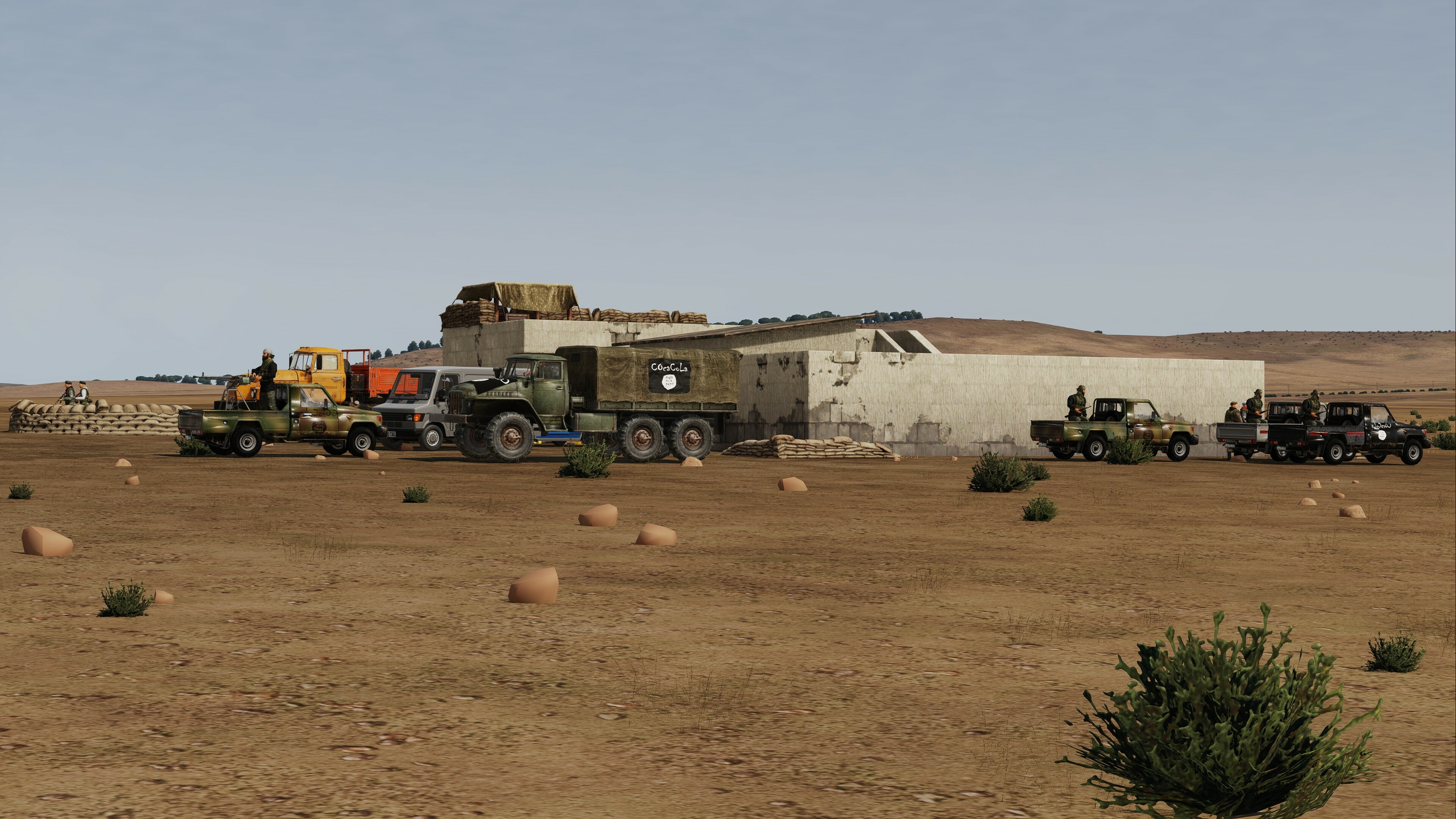
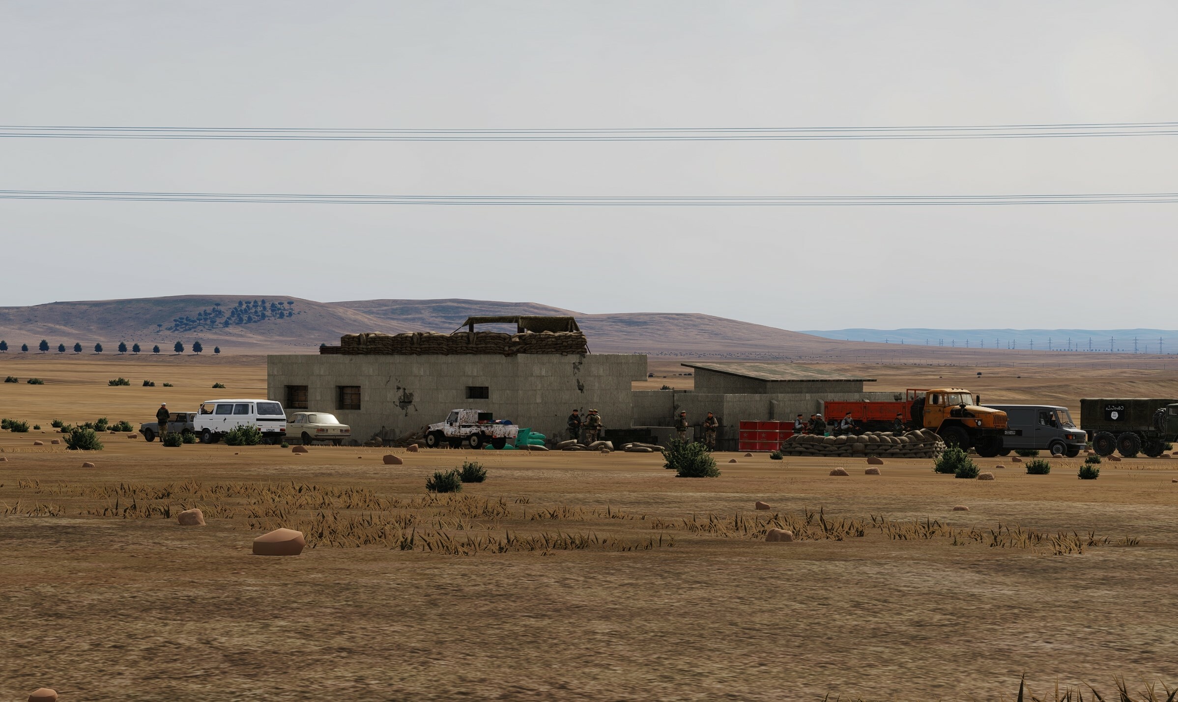
100%. I love this asset pack, been an important part of my mission editing. I reverted to 2.3. Even then, some of my most important mission assets are no longer included. I would highly recommend keeping all the original assets and keep adding, instead of picking and chosing assets to no longer include, which all happen to be very popular amongst mission designers. In my latest mission, here is Khalil the Assasin's IED factory from the ISIS-K faction "Agents of Allah" in central Syria using the HD outposts and other assets not included anymore on 3.0:
4 points
-
Hey Central, I hear you loud and clear. I don't understand why they created the SA Map but didn't create those mods you mentioned. They have a team of guys that could create them in no time. I think they are not a priority so it's up to us to provide them. For us loner 3D Modelers. We have our hands filled with future projects. I have enough projects to take me well into 2026. Fearless wouldn't be a difficult mod to create but as mentioned I don't see any 3d models out there of her. What type of ship is Endurance? I see two vessels out there with the same name. So about contributing. I honestly only need assistance with creating Liveries every so often. Also, deck landing spots and parking are the others especially when it comes to the big decks. Everything else has to be worked out in 3ds max. I usually send out my models for testing before release to see if I've missed something or to get another opinion about how the mods perform. As you can see I don't need much assistance. When I am focused I can complete a model in no time. Right now I'm finishing up the Iranian IRIS Alvand Class Frigate. It will be done soon. I'm testing the capabilities of adding the Ukrainian SeaBaby and Magura V5 to DCS. So far so good if it gets close enough to the ship. WIP.4 points
-
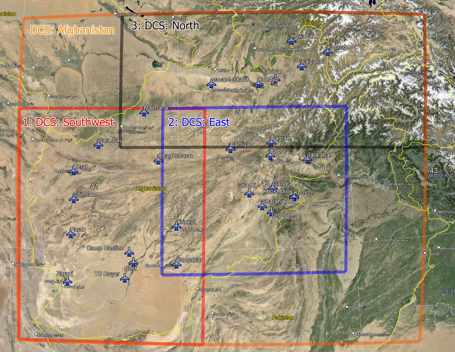
DCS: Afghanistan and DCS: Southwest Afghanistan are now available for pre-purchase and are planned to enter Early Access in June 2024. The vast and varied landscape of DCS: Afghanistan will provide a stunning environment in which to experience some of the most important conflicts of the past half-century. The entire map of Afghanistan and small portions of neighbouring countries will be available, showcasing our latest map technologies at a superb level of detail and fidelity. You can pre-purchase the full map of DCS: Afghanistan with a special 30% discount at $48.99 during the pre-purchase phase. The early access release price will be set at 20% off ($55.99) until the final release. In addition to offering the whole map as one purchase, and given the immense size of the territory, we have also divided the map into three regions each available for individual purchase: DCS: Southwest Afghanistan, DCS: East Afghanistan, and DCS: North Afghanistan. Each regional map gives you access to the entire Afghanistan map but grants the highest level of detail for that region only. Regions will be released in approximately three-month intervals. The southwestern region is the most complete today and will be released first. Today, you can pre-purchase DCS: Southwest Afghanistan for $23.99. The release price in June 2024 will be set at $29.99.DCS: East Afghanistan and DCS: North Afghanistan will be offered for individual purchase as and when they are ready, later in the year. There will be no pre-purchase price for these, which will be set at $29.99 each. If you wish to gain full access to these at release and wish to lock the best price, we recommend that you purchase DCS: Afghanistan now during the pre-purchase phase. A purchase of DCS: Southwest Afghanistan makes the entire map flyable in single-player and multiplayer, but only the southwestern region will be at the highest level of detail once the map is complete. This FAQ should answer the most common questions you may have. *I Want the Whole Map in High Detail* Excellent! Nothing changes for you and this will be like every map you have bought in the past. You need to purchase DCS: Afghanistan. At the release of Early Access, you will have access to the whole map, but only the Southwest region will be in high detail and the others will be in low detail. Once the East region is ready, you will also see this in high detail. Once the North region is ready, you will also see this in high detail. *Why Is the Map Available As Individual Sections?* Please understand that this is one map, and you can buy the whole map in exactly the same way as you can with any other map. If you buy DCS: Afghanistan, you will have the whole map in high detail once each region is complete. However, if you do not want the whole map and are only interested in a specific region, you have the option to buy only that region. If you do this, you will still have access to the whole map, but only the region you wanted will be in high detail, and the other regions will be in low detail. This is ‘Southwest’, ‘East’, and ‘North’. The reasons for offering the split regions are: 1. Allows a lower entry price if users want to fly one region only. 2. Everyone is able to fly the map sooner. The regions of the map are being completed in stages with Southwest ready first, then East, then North. If we waited until the whole map was ready in high detail the Early Access release date would be much later. What Does DCS: Afghanistan Offer? This Afghanistan map includes the rugged mountain ranges of the Hindu Kush, the vast deserts of the Dasht-e Kavir and Dasht-e Lut, and the many green fertile valleys and river basins of the region. Efforts have been dedicated to accurately portraying the unique cultural and urban features of Afghanistan. This involves recreating cities like Kandahar and Herat, with special attention to landmarks, infrastructure, and architectural styles like the blue mosque of Herat. High-resolution satellite imagery has aided authentic terrain textures and details, while aerial imagery has been used to enhance the accuracy of individual areas. Special focus is being given to the detailing of terrain features, including rivers, roads, vegetation, rocks, small stones, ground clutter and geological formations. The terrain presented is a representation of modern Afghanistan, most closely matching the years between 2008 and 2010. The map has been developed to offer gameplay that spans the many eras of combat in the region. This is our most ambitious map yet and the sheer size, diversity of the terrain, and complex topography of Afghanistan have presented technical challenges, pushing the boundaries of our map-making technologies. Performance optimization and development is ongoing, allowing the map to look good at both low and high altitudes. The illustration below details the size of the whole map, and shows how it has been split into three distinct regions: The regions have been divided in a way that offers maximum gameplay and re-enactment potential. The highest level of detail in each provides greater detail of terrain textures, a highly detailed road network, enhanced city scenes, airfield scenes, unique objects and cultural monuments, as well as improved texturing to a variety of buildings, vegetation, static cars etc. Please note that airfields are only planned within the borders of Afghanistan. There are currently no plans to add airfields from neighboring countries. DCS: Afghanistan (total) Area: 1449216 sq km 28 Unique highly detailed airfields DCS: Southwest High Detail Area: 471381 sq km 12 Unique highly detailed airfields DCS: East High Detail Area: 320529 sq km 12 Unique highly detailed airfields DCS: North High Detail Area: 443199 sq km 8 Unique highly detailed airfields The highest level of detail for each region is only available with a purchase of each of the individual region products (Southwest, East, North), or with a purchase of DCS: Afghanistan. Regions that have not been purchased will be flyable but will display a lower level of detail. Please note: The low vs high res areas will be analogous (similar) to what we have with Normandy 1944 and Normandy 2.0 Upgrade option. What Is Included in DCS: Southwest Afghanistan? The image above shows the area that is included in high detail with a purchase of DCS: Southwest Afghanistan. The entire DCS: Afghanistan map will be flyable at launch but is still under development. DCS: Southwest Afghanistan will receive some updates post-release but will for all intents and purposes be feature-complete. This region includes 12 highly detailed airfields: Kandahar, Herat, Bost, Camp Bastion, Chaghcharan, Dwyer, Farah, Maymana Zahiraddin Faryabi, Qala i Naw, Shindand, Tirinkot, and Zaranj. The southwest region is currently the most complete and will be released first. The second region to be released will be the Eastern region and finally the Northern region. Please keep in mind that even if you purchase only one region, you will still be able to play online across the whole map with your friends and in your favourite servers, but the non-purchased regions will display lower detail. How Much Will It Cost? Early adopters in the pre-purchase stage will enjoy special discounts. The pre-purchase phase is planned to end in June 2024 with the Early Access release of DCS: Afghanistan and DCS: Southwest Afghanistan. Pre-purchase Early Access Release DCS: Afghanistan $48.99 $55.99 $69.99 DCS: Southwest Afghanistan $23.99 $29.99 $29.99 DCS: East Afghanistan N/A N/A $29.99 DCS: North Afghanistan N/A N/A $29.99 DCS: East Afghanistan and DCS: North Afghanistan will not receive pre-purchase nor early access pricing. Please kindly note, that the pricing above may be subject to change. How Do I Purchase DCS: Afghanistan? Pre-purchase DCS: Afghanistan in the e-Shop, here. Pre-purchase DCS: Southwest Afghanistan in the e-Shop, here. Pre-purchase is not currently available on DCS Steam Edition. We are doing our best to offer Steam users identical pre-purchase options for both DCS: Afghanistan and DCS: Southwest Afghanistan as soon as possible. After early access , we will include DCS: Afghanistan in the two-week Free Trial Program on the e-Shop. The product will then be available for download via the in-game module manager for you to try before you buy. The Free Trial programme extends to most DCS modules; look for the ‘Trial’ button in the e-Shop for participating modules. What Happens if I Buy the Map Regions Parts Individually? While purchasing the whole DCS: Afghanistan map in one go will grant you a significant discount, you may wish to purchase only an individual region if you have a particular interest in that region only. By purchasing individual regions, you are curating the areas of the map that you wish to see in high detail. This option makes the map more accessible for those only interested in specific areas or are on a budget. Purchasing any of the individual regions will still give you access to the whole map in low detail. Those who purchase one region will not receive discounted pricing if they subsequently wish to purchase other regions. To enhance the detail of the map, additional regions may be purchased separately, as and when you wish. Those of you who purchase DCS: Afghanistan as a whole will have the exact same access as another user who would purchase all of DCS: Southwest Afghanistan, DCS: East Afghanistan, and DCS: North Afghanistan individually. Can I Fly with Friends or on Servers if We Have Mismatching Regions of DCS: Afghanistan? Yes, you are all flying the same map and will be able to fly together without issue but the detail that each of you sees will differ. Remember that by purchasing individual regions you are curating the areas of the map that you wish to see in high detail. Those who purchase the whole map will see the whole map in high detail as and when each region becomes available and receive updates during the Early Access phase. Will I Have Multiple Maps if I Purchase Individual Regions? No. All purchases give access to one map and individually owned regions dictate what you see in high detail within that map. If, for example, you own both DCS: Southwest Afghanistan and DCS: East Afghanistan, you will see both of those regions in high detail and only DCS: North Afghanistan will be in low detail. How Might Missions and Campaigns Be Affected by the Individual Map Regions? If you are flying in a region where you do not have access to the highest level of detail, it may be that the creator of that mission or campaign references a world object you are not able to see. Otherwise, there will be no effect. Will DCS: Afghanistan have Winter Textures? (ADDED) Not at release, but is planned for later on after the Early Access Launch. If I only own 1 part, will I still see and be able to use airfields on parts I do not own? (ADDED) Yes! Once the entire map is complete and if you only own 1 section, you will see the entire map, and the airfields in those unpurchased sections will be there and usable in the sim, including the ME. You will still see trees and buildings in these areas as well but in low-detail LODs. What does Early Access, Features and such mean for Terrain and how does it compare to Aircraft modules? (ADDED) We have noticed some confusion on what Early Access means for a terrain, especially one being sold with the possibility of owning only 1 or 2 parts. Features on a Terrain can be described as things like Airfields, Cities, POI's and such. Saying the SW portion is mostly feature complete it's for these types of objects and areas. What it doesn't mean is that those areas are necessarily done in layout or textures, all these things can change during Early Access. This also goes for textures, for example, some have pointed out areas where highly detailed abruptly bump up against low detailed areas. Even in the SW regions, this is still very much WIP. The challenge of doing a huge map like this is maintaining a reasonable size and performance. The idea here is to get the most out of the high-detail areas for all 3 areas, then go back and see how much we can push those medium-detail areas you would see between High and Low areas. If we were to complete the SW area before the others and push it to max levels before the other 2 areas were in, we run the risk of having an unmanageable sized map, or one with poor performance, and would require us to go back and pull some detail out. This is a very new way of doing a map, along with one of the biggest and most detailed maps to date, there will be some growing pains and it will look rough in places at times. We appreciate all those who are willing to continue on this EA with us, and we look forward to all your feedback and reports on the map! More sources of information: DCS: Afghanistan CasmoTV and Wags interview We are truly thrilled to bring this monumental map to DCS that will allow you to explore and experience a region that has been so important to the late 20th and early 21st century. Thank you all for your trust, passion and support. We look forward to your feedback and suggestions. Please ask any further questions you may have below as comments. Yours sincerely, Eagle Dynamics Updated Maps: New Map Previous Map
3 points
-
Strategic DCS is a relatively new (under 1 year old, built from the ground up) server that has spent our time with little advertising as we continued to test theories, trying various mechanics (removing and tweaking many that didn't work out as envisioned!) and ultimately polishing the product to a place we were happy with to invite more users to experience it. Our focus has been to find that balance between fun and rewarding without resorting to having too many chore tasks impacting those with limited time to play and our focus on personal impact over coalition wide punishments. Find Us: Server Name: SDCS | strategic-dcs.com | Persistent Dynamic CA Campaign Server IP: dcs.strategic-dcs.com / 46.4.114.80 Unique Features, What makes us different: Real Time, dynamic FARP placement Obtain a base crate from an existing Airbase / FARP with shelter and load into your Plane, utility chopper, or even truck Place this in a suitable location (green filled triangle on F10 map) and unpack! Immediately be able select the location from the slot list, and spawn at the exact location! Exclusive Player JTAC Capabilities Help your buddies out; By flying a mi8, huey, or gazelle you can spot enemy units, and automatically update nearby helicopters for highly effective hunter-killer sorties Anti Tree Technology We know how frustrating finding player controlled units deep in the forests, especially on caucasus can be. We have developed a solution to prevent this by automatically notifying and de-spawning units that head too deep into forests - you won't need to spend hours trying to bomb impenetrable trees! Take a look at our Caucasus deep forest map: (red = deep, orange = shallow, purple = road, allowing us to place mobile units in the treeline along roads, but static objects like shelters not in the trees, and never too deep they're unstoppable and tedious to find!) Even more detailed option (still scaled down from 29,000x16,000px) : https://strategic-dcs.com/storage/caucasus_overlay.jpg AutoGCI Not every module has decent Data Link, not everyone is on comm (Discord / SRS Primarily). Our AutoGCI updates you every 30s (or as requested) known threats collected from E2, Radars, and even line of sight from ground units, with all calculations occurring outside of DCS so we can ensure we maintain optimal performance within the game environment Don't Panic! We care about our rotary pilots, and you have opportunity to remain hidden! (see our wiki) Chat Commands / Discord We love looking at ways to enhance collaboration, discord based Situation Reports channel to provide players with the current objectives when they spawn along with in game chat commands to create map markers, and push the targets to coalition-locked discord channels - no more searching for the target your TPod has on the F10 map, just use the coordinates! -target N 26 46.104 E 055 51.798 -- MBT This will place the marker on the map on the correct location and dispatch to discord! General Features Player controlled ground war! We grant full TacCom access to all players. The majority of units player ordered from factories using Map Markers and flown by AI flights, or loaded and flown by players themselves. Every unit life matters, and the ability of ground force commanders to control the sings of combat offer significant advantages - do you push from the ground? focus on clearing from the air with reduced ground force ? Your coalition has full control over your strategy. We have a global Resource Point cap, but the freedom to chose how to spend those resource points to focus on any particular asset type and the risks that come with should they die (A large battle may see your strength reduced for some time as resource points regenerate) Live Map and detailed stats We collect a lot of stats, every flight, how far you traveled, how many shots you took during each leg of a flight etc. are almost out your fingertips. Whilst the stats website is new, the front end, API, and even a database dump with real data is available to allow our community to update and submit pull requests to increase coverage and get access to anything you want (or request we add to the DB!) Splash Damage We make use of FrozenDroid/Grimm's fantastic Splash Damage script to ensure dumb bombs remain practical Tacview Whilst we do not run Tacview on the server, we do generate tacview compatible ACMI files from our engine outside of DCS. This allows us to have even more information in our tacview files without incurring the high lua CPU usage that an embedded tacview generator causes. This includes player markers, JTAC markers, if you were detected by AutoGCI or not and player chat and even which player was driving a specific vehicle at any time! Ultimately, this allows us to use tacview as an interactive log for both to help assist players. At the end of each campaign these are made available to download (Soon the stats kills/deaths page will have a link to the download the tacview associated with the kill/death without you having to navigate to it yourself) Checkout last campaigns data here: https://strategic-dcs.com/tacview/2024-03-25-1638-Syria2/ Map Rotation: Currently we operate: Caucasus -> PG -> Syria -> Caucasus Inverted -> PG Inverted -> Syria Inverted Our Inverted campaigns are where the starting locations are swapped, ensuring another source of variation every campaign. Module Layout We understand module layout is a contentious subject, and we have to try and find a compromise to avoid one side stacks that push us into a PvE server. Our community so far has been keen on each side having it's own identity and strengths and weaknesses. From the ground war, it's mostly west (Patriot, Hawk. etc) vs east (SA10, SA11) but on the air side this is not really possible. For more information please see: https://wiki.strategic-dcs.com/en/home Community Driven We are strong believers of taking a community driven approach; whilst we will never be the one and only for everyone, we do try our best to encourage discussion, take criticism (particularly when constructive!) about things that are working well, more so what doesn't work so well, and most of all feedback as to how we can improve, and develop in the direction the community wishes to go. Documentation An up to date wiki with all features and capabilities can be found: https://wiki.strategic-dcs.com Credits Like all projects, we build upon the knowledge and products of many others that should be acknowledged; In particular, we make extensive use of DCS gRPC for all communication between DCS and our "engine" that handles all our mission logic outside DCS. This, coupled with PyDCS ensures we save a huge amount of time in maintaining our mission files themselves that clients download to manage our aircraft spawn positions, skins, options, laser codes and more all from a config file. Contact Us Please, feel free to join our discord: https://wiki.strategic-dcs.com/discord or feel free to reach out via PM here or on discord (martin.co) for any specific questions you may have3 points
-
Perhaps, the mission designer WANTS the player to do the actual planning. Currently the mission designer creates the scenario AND does the mission planning. Ideally mission designers could choose if they want the player(s) to make their own planning. Additionally there are several rather important things, that cannot be preset in ME. For example CMS programs... It will also be important for the "upcoming" dynamic campaign, where the scenario is procedurally evolving and players are asked to come up with own missions and mission planning...3 points
-
Летают же люди в ГА-симы рейсы типа KLAX-RJAA в онлайне. В военном авиасиме тоже полно применений с длинными полётами. Например: перегонка борта, сопровождение VIP-а и т.д.. Тем более и Геркулес обещали.3 points
-
That's because there isn't a setup or trim for "proper use". The pitch ladder on the F-14 HUD isn't at all referenced to the outside world, it just references the wings on the HUD. You should regard it as an ADI on the HUD and an instrument in itself not referenced to the outside world.3 points
-
Neatly explained, ED should take a look at this!3 points
-
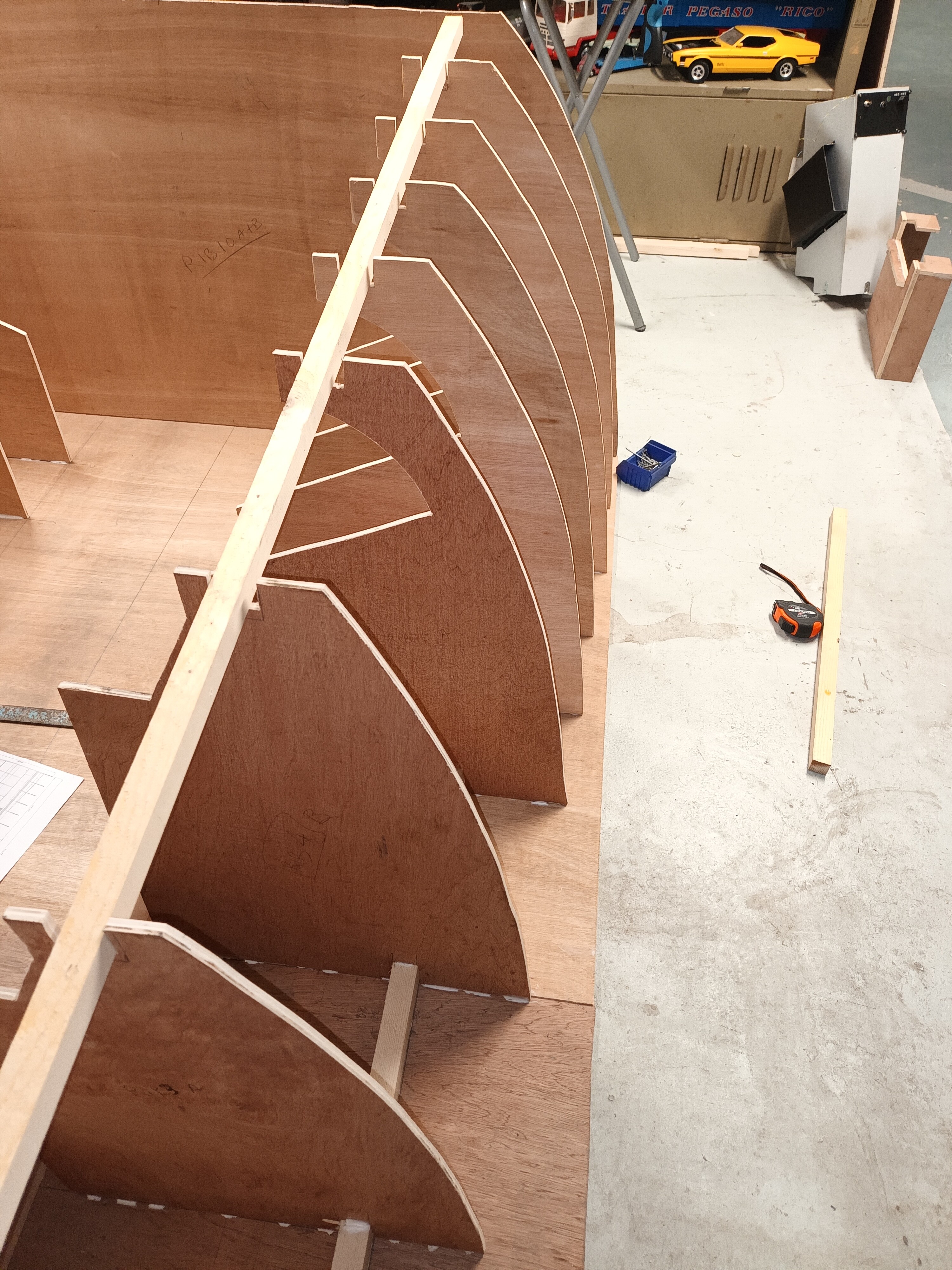
Work in progress !!
3 points
-
You're not strongly disagreeing with me. In fact, you're rather strongly agreeing. I want additional airfields, including Mary in the northwest. I want the western border of the map be shifted east a couple of miles, closer to the western airfields, so that more airfields in the neighbouring contries to the east can be created in order to bumping up the overall value of the map.3 points
-
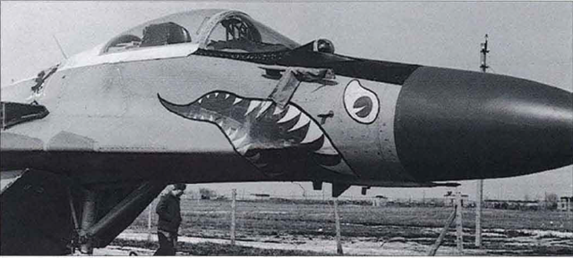
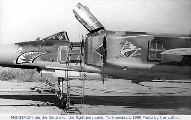
Strongly disagree. Mission development would be significantly enhanced with the development of the Western side of the map to include Mary (1521st Centre for Combat Employment) - This is especially important with both the MiG-23 and full-fidelity MiG-29 on its way to us within DCS. Developing the Western side of the map (Mary) would result in a map that is capable of hosting historically feasible missions for both RedFor and BlueFor. It would also enable the long military history of Afghanistan to be rightfully and correctly represented instead of having the Afghanistan map simply be nothing too much more than a virtual bombing range for BlueFor. Whether Mary is to be added exclusively to the full Afghanistan map (if at all), or a future sub-map for people that just want a cost effective alternative to fly their MiG-23 and MiG-29 within a community of like minded enthusiasts, I do believe that Mary is an absolute must have - noting as well that the FC3 MiG-29 already has the liveries of Mary. I have attached two pictures showing the MiG-23 and MiG-29 with their unique nose art that was found on aircraft posted to Mary.
3 points
-
I believe on the KC-135R, the Tomcat had to plug into the basket enough to put a kink in the hose, and maintain that. This is because that particular hose comes off of the boom, and is not very flexible, and only 10 feet long, so doing this helps the fuel properly flow. That is probably what one sees in video where the probe is being "rammed" into the basket. IIRC, it isn't done on any other refueler. IN fact, this has earned the KC-135R the nickname "Iron Maiden" from Naval Aviators. Some poor soul wrestling with the Iron Maiden: From a Hornet driver: I also find the Tomcat to be easy to refuel, possibly more than the Hornet, but that's subjective. Once I'm plugged in the Tomcat, I give it a very small throttle shot and bring it back that small amount every other second and I stay plugged. Of course that also depends--if I end up starting to overtake the tanker, I skip the shot for a second or two to compensate and I'm fine again. No matter what the technique you use, just remember trim, and very VERY small control inputs and counter them immediately with the opposite input to avoid PIO. You know are in close formation and as you probably know, the control inputs get tinier and tinier the closer you are to the aircraft you are flying with. Or, think about an ILS approach or a ICLS approach. The closer you get to the runway/carrier, the more sensitive a control input is. Be mindful of that when tanking too! v6, boNes3 points
-
Because the tantrums that are being brought with little regard to understanding the "why" of things, as well as refusing to accept the answers given, is beginning to get childish. Enjoy the new tech that's being pushed to make this map happen, and look forward to the future world map a few years from now. Or not. Just stop beating a dead horse thinking it'll do what you want.3 points
-
WIP VID_20240330_155251_047.mp43 points
-
Now working on this guy...
3 points
-
Thank you for your reply. Let me explain why this is a decision that can be improved upon. Apart from the fact that Mary, Turkmenistan was the home of Авиабаза 1521, Мары - Центр боевого применения | Airbase 1521, Mary - Combat Operations Center or else known as Soviet Top Gun, this is the perfect home for the full fidelity MiG-23 and the MiG-29. Additionally, together with the Kokaydy airport in Termez, Uzbekistan, they played a very important role for the Soviet Union's operations in Afghanistan from 1979 to 1989 for various aircraft that are available already or are coming soon to DCS World. MiG-21, MiG-23, MiG-29, Su-17/22, Su-25, Mi-24, Mi-8. Since you mention "Soviet operations of the 1980s place Afghanistan as one of the most important combat theatres of the past half century." in your product description, it is only reasonable that we have the airports available to historically re-enact those operations and create scenarios that will bring the community together. If you need more information, please do not hesitate to pm me.3 points
-
While this has been mentioned before, I am making a specific wish for an expanded set of map tools. I am missing the following: A dedicated new map (not the current AWACS-view). Basically, allow to open the map with only the tools listed below. This map would function as a normal physical map that a pilot has. Everything drawn on it, would only be shown to the pilot of thay given aircraft (individual between crew-members). (The AWACS-view, could be used as a modern "tablet" that crew-members use. Allow the mission commander to draw on it such that it's visible to everyone in that coalition. If a crew-member draws, it only shows for them. Essentially, have a military command structure associated with the AWACS-map.) For the paper map, following tools are needed: - A proper ruler (I wish to find out the range between two points myself, with the given map scale, instead of having the current "automatic" inplementation. - An ability to draw on the map (lines, icons, add comment bubbles (better than whatbis currently implemented - on a white background and able to stay open, unless I specifically close it). - Don't allow to perform any zooming on the map. Only view-zoom. The map should function exactly like a physical one (think of the Mi-24P doppler map - if you want to move the map around, you have to jump between zones, not fine moving). With this system, allow to select was is permissable in the mission setup - paper map/AWACS-view/both. That way, one can adjust the setup to a given historic scenario. Also, have the physical map, preferably show more realistically in the cockpit (laid out on the legs of the pilot, or so). The expanded map tools, are especially a much needed functionality. zerO2 points
-
2 points
-
Самое смешное, что людям дали самую огромную карту, и первое что они сделали - стали искать территорию за ее пределами.2 points
-
I wish it would happen as well. I miss the Crimea map. The people who created that one clearly loved the area. So many of the sites around Sevastopol and the rest of that map were recreated with their distinctive structures, etc, unlike the cookie cutter buildings we have on the Caucasus map. And, since this is a wish list, I wish it could be done again. Unfortunately, the chances of that are 0%.2 points
-
Hello, I took a while, but today I finally finished the M13 training mission, covering the Rb05 missile on Air-Ground attacks: Edit: I just realized that I failed to acknowledge the help that I received from both @Goblin and @hilmerby who provided information about the way the Rb05 was employed in real life, thanks so much to both of them.2 points
-
I finished about 3 feet from the parked hornets, with collapsed gear pointing nose towards the wires... Airboss said I should have ejected,.. I said he should have rigged the barricade, we agreed to disagree... I'm currently in hack, send hacksaw...2 points
-
At least two: https://news.lockheedmartin.com/2011-10-05-THAAD-Weapon-System-Achieves-Intercept-of-Two-Targets-at-Pacific-Missile-Range-Facility2 points
-
c‘mon, that‘s too harsh. it‘s some of the best software i‘ve ever encountered. just because you can‘t access your favourite toy, some of you acting like little children… thank you ed for fixing all the problems.2 points
-
my bad, i didnt check the timestamps of the posts here and in the other threads! If its done for you, i'm glad. Think i came across too much like a "wise-ass". That was not my deeper intention. Im just happy to get more maps, especially with Afg, cause if been there for two tours. It feels like i played on Caucasus for a hundred years (started with LOMAC around 2005...) Now i do feel old thy2 points
-
The indexer lights are fine. I guess you are putting the fpv into the E bracket like you do in the Hornet. That's not how it works in the Tomcat. The E bracket references the aircraft symbol in the HUD instead, so but the center of the E bracket on the tip of the aircraft symbol's wing and you will get a yellow O light.2 points
-
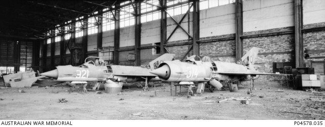
Good rebuttal! I agree!! Slight changes to existing plans in order to make any map more playable and host more historical scenarios is great for us end-users. However, it is even better for ED because they will have a product that is in higher demand and thus will surely become a greater success financially. Now for a tangent! Just to emphasis the importance of the Soviet influence within Afghanistan and the surrounding region, I found this picture in the Australian War Memorial online archive with a description of the image: "Dilapidated Mikoyan-Gurevich MiG-21 interceptor aircraft numbers 321 and 314 in a hangar at Bagram air base. They had been supplied to the Afghan Air Force by the Soviet Union. The Soviets made extensive use of Bagram airbase during their occupation of Afghanistan. It was contested by the Taliban and the opposition Northern Alliance from 1999 to October 2001. During the United States led invasion of Iraq, following the terrorist attacks of 11 September 2001, it was secured by members of the British Special Boat Service. It was then used as a base by Australian special forces and by American army units." Now, we know that the Bagram airbase is going to be included (right?), but, no one wants half of a scenario by neglecting historically significant locations that are within the boundaries of the map already.
2 points
-
Yeah same here, I just hope they'll drop the Phantom soon, so that development can go full steam on the Typhoon2 points
-
@Cobra847 I appreciate that you've got your hands full with the impending F4E release, just wondering if there's any possibility that for some of us who are huge Heatblur fans but looking forward to the Eurofighter, we might get a small development update on the Eurofighter at any point in the near future? My most anticipated module by a long shot!2 points
-
Hi @Rolds. Sorry for being so late, I was very busy. Your track is just great. I'm able to determine that, at a speed of 322 knots: The unconnected S-3 loses ~94 lbs / min. The unconnected F/A-18C loses ~69 lbs / min. The connected S-3 loses ~4492 lbs / min. The connected F/A-18C gets ~2884 lbs / min. It means the S-3 gives ~4398 lbs/min while the F/A-18C receives... only ~2815lbs/min. The hose has a serious leak: 36% of the fuel is wasted! From your calculations, I find the leak amounts 35%, so it seems we both got the figures correct. Issue reported. Thanks for the hard detective work.2 points
-
please stick to the DCS: Afghanistan topic here. thank you2 points
-
To explain further, in missions without easy comms, you must press the radio push to talk or transmit button to open the comms menu when in flight. This simulates the necessity of using the radio to communicate outside of the airplane This is true in all full fidelity modules AFAIK.2 points
-
Why land at all? Just split your mission up in 3 parts if you persist on carrier ops+Afghanistan and use the "load mission" function from the ME. One can start from PG map on a carrier, fly in the direction of Afghanistan (following waypoints), and then at some point just auto load the next mission (Afghanistan map). Mission 2 you'll start airborne, drop your bombs, return towards PG, auto load PG mission, land on carrier. (oh and add some AAR to make the boring long trip bearable) If the player stays reasonably close to the intended waypoints and altitude, the transition between missions is quite good (I know because I tried it with Sinai and Syria maps) (Ok true, this only works for SP)2 points
-
It only has to be open if you have no radios available. You need to go to the DTS page and manually load the DSMS. Press and hold any of the lower MFD buttons for a bit until a new page shows up. Select "Load" and press on any of the lower MFD buttons. Press that button again to enter the LOAD page and press "Load all" or "load DSMS" or whatever you want. There is a manual, training missions and tons of videos available for you to take a look and study.2 points
-
I fully Agree With Ronin, not including Mary airbase in an Afghanistan map will be like not including the USS Midway in a Battle of the Midway Mission. Having Mary in the map, will convince many fence sitter Redforce players to buy this map. I urge ED to please consider doing this.2 points
-
Men you are discussing without end about 20 bucks while you are ready investing hundredth or thousands in your rig, setup and controls and wait the release of a new stuff for months ….. stop kidding! buy the whole map for a very good price and wait the full release …..stop complaining ….full stop2 points
-
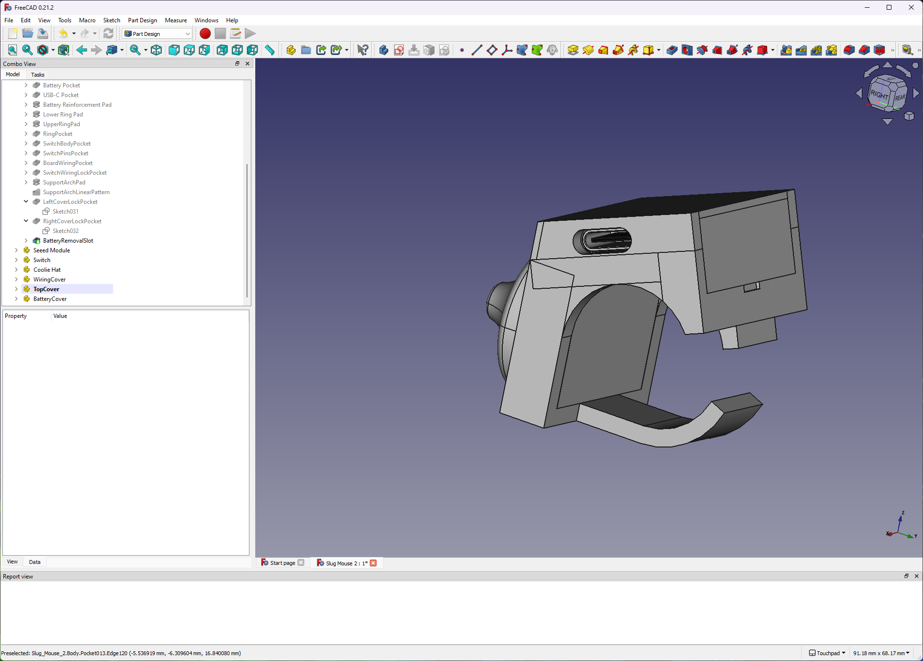
I'm not far off finishing this pointctrl alternative. It's been fully redesigned from the ground up. The software is done. The battery will last days without needing a recharge, which should take about an hour. It will now hibernate when not used for a while, say 15 minutes, and can be woken by pressing the middle button. Battery status is available via the Bluetooth devices in Windows. Perhaps another week to finish. I think I will christen it the "Slugmouse".
2 points
-
Why? DCS ground units and AI are pretty bad. Like the whole air to ground interaction systems of units under air attack is terrible. DCS mission maker issues aside where they park a tank/infantry platoon in the middle of an empty field aside. Once attacked those vehicles/infantry should be moving as rapidly as possible to actual cover (where they would have been IRL anyway). DCS AI gunnery for non radar guided AAA is absurd. The BMP-1 or 2 are still better than dedicated AAA platforms like the shilka, and every guy with an unstabilized 50 cal is vasiliy zaitsev. And never mind stuff like shorads vs fast jets. Literally unless a unit is notified by radio or have their own radar running, they have almost no chance to react to a fast jet attack IRL. There is literally no time to react to something coming in at 500mph. and most infantry shorads basically need like 30 secs (it varies) to actually cool the seeker and get ready to fire, assuming they actually hear/see the jet coming in the first place. But in DCS AI spotting is perternatural levels of vision and SA, all AI units immediately know where you are and immediately begin to direct insanely accurate ground fire at you. Instead of doing what would actually do IRL which is run for cover. Never mind the actual after effects of CBU-ing a set of units. They literally do-not care unless you actually fully destroy the unit, there is no morale, no shock of "holy cow" we almost just died. Just T1000 levels of determination to kill you. These problems have been major issues for years as well, so I have 0 faith that ED will do anything to actually improve this systems, or things like SAM's in DCS which are also variously broken. You'd think for a game where the critical pieces are the bombing things or getting shot at by sams that it would actually have a higher priority to make it more realistic but its just not and never really has been. Who actually cares about animations? I mean the only thing there is so ED can post some replica "kill videos" from GWOT in some trailer, which is tacky and in poor taste at best. Actually modeling realistic AI behavior should 10,000x more important. Same with "gunnery" effects. I can guarantee you private snuffy or mr tank commander's first priority is not having a showdown at the O.K. corral with enemy helo or ground attack jet, their first priority is getting under cover where they won't get murdered by enemy air, and let the attached ADA detachment deal with it. As for soviet units, yeah we desperately need older SAM systems that are the most commonly used ones in the world, but we have needed them for a decade and still nothing.2 points
-
Found it. It's called "IMA ISO GPS No Frame". https://www.myfonts.com/fr/products/regular-ima-iso-gps-no-frame-18176?queryId=a05d4873e23d41c99575b06b0239f469&index=universal_search_data&objectIDs=53856650022 points


.thumb.jpg.32e1e6aa74a1bb629307c4af31b91df1.jpg)


-
Recently Browsing 0 members
- No registered users viewing this page.